Published: April 2,2016
Isolated strong to severe thunderstorms may affect portions of the Florida peninsula into Saturday evening. Damaging wind gusts, flash flooding and a few tornadoes remain the greatest potential hazards.
At least 20 tornadoes have been confirmed across the Plains, Midwest and South since Wednesday. The tornadoes affected parts of Kansas, Oklahoma, Louisiana, Arkansas, Indiana, Tennessee, Mississippi, Alabama and Georgia.
(MORE: Severe Weather Hammers the South)

Current Radar with Watches and Warnings

Below is a look at the current expectation for the severe weather threat into Friday.
Severe Weather and Flash Flooding Forecast
Into Saturday Evening- States Impacted: Strong to marginally severe thunderstorms will weaken across the Florida peninsula early Saturday evening.
- Potential Impacts: Damaging wind gusts and flash flooding are the primary impacts, although an isolated tornado cannot be ruled out.
- Cities: Orlando | Tampa

Saturday Night's Thunderstorm Forecast
Friday's Tornado Reports
A radar-confirmed tornado caused damage near Warner Robins, Georgia Friday morning. Winds gusted to 80 mph in the vicinity of the storm. To the east, the parent thunderstorm went on to produce an EF1 tornado near Allentown and Montrose. At least two homes were destroyed in the area.Late Friday afternoon, emergency management reported a tornado near Cogdell, Georgia. Although radar also indicated a tornado, as of Friday night, there has been no confirmation made by the National Weather Service.
Additional storm surveys through the day on Saturday may reveal more information on the above-mentioned and other storms from Friday.
Thursday's Storm Reports
Earlier Thursday morning, two relatively weak tornadoes were reported in Louisiana.Thunderstorm winds caused damage to buildings near Hardinsburg, Kentucky Thursday afternoon. A roof was blown off of the gym at Breckinridge County Middle School according to a National Weather Service report. Damage to trailer homes in Utica, Kentucky may have been caused by a tornado.
Early Thursday evening, a tornado ripped through New Hope, Mississippi, displaying a "debris ball" on radar, indicative of lofted debris from a tornado. As the storm crossed into northern Pickens County, Alabama, at least two EF1 tornadoes also touched down, according to the National Weather Service. Another storm in southwest Alabama, near Gilbertown, may have also produced a tornado based on radar signatures and damage reports.
Thursday night, the National Weather Service confirmed a tornado near Millport in Lamar County, Alabama, while a tornado was also confirmed in Morgan County.
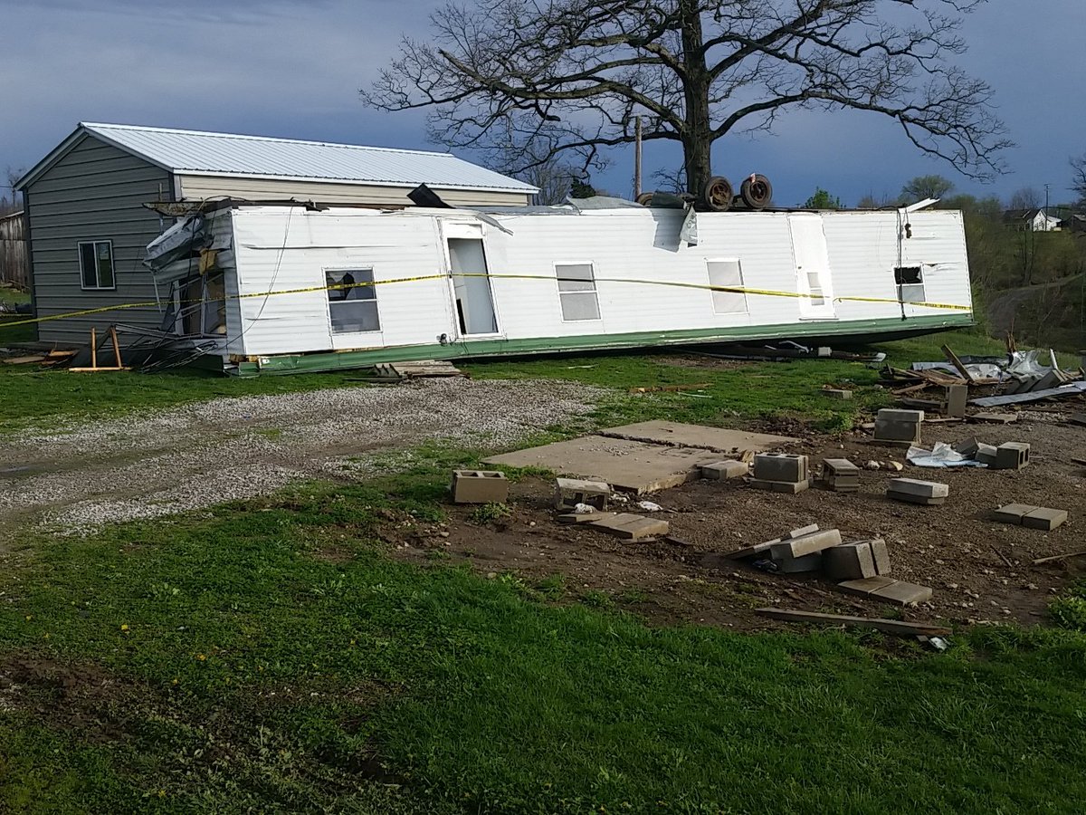
This mobile home in Breckinridge Co. KY rolled over during strong winds this afternoon. #kywx #wave3news
In Indiana, wind gusts reached 61 mph at South Bend Thursday afternoon. After additional rainfall on Thursday, Memphis, Tennessee was reporting March 2016 as their fourth wettest month on record.
Wednesday's Severe Weather
Wednesday afternoon, tennis ball size hail has been reported near Breckenridge, Texas. Golf ball size hail also covered the ground near El Dorado, Kansas. Multiple storm spotters reported a brief tornado near Dexter, Kansas late Wednesday afternoon.Wind gusts reached as high as 70 mph at Burleson, Texas early Wednesday evening and 67 mph near Waurika, Oklahoma Wednesday afternoon.
Major flooding in Jonesboro, Arkansas prompted a flash flood emergency for the area, which has since been canceled. Some minor to moderate flash flooding was also reported in the greater Little Rock, Arkansas area.
On Wednesday evening, a tornado spun through the north side of the Tulsa, Oklahoma. Damage to buildings and power lines was reported in the Tulsa, Catoosa and Claremore vicinities. Heavy damage was also reported in the city of Dermott, Arkansas, due to a possible tornado late Wednesday night.
Tuesday's Storm Reports
A cluster of thunderstorms rolled across central to south Florida on Tuesday afternoon. The storms were accompanied by some hail, gusty winds, dangerous lightning and locally heavy rainfall.Three firefighters were injured while responding to a fire when lightning struck an overhang near Boca West. A large tree was knocked down by thunderstorm winds, just to the northwest of Boca West. A wind gust to 56 mph was reported near Boca Grande.
(MORE: Impacts From Florida Storms)
In Nebraska, two rounds of thunderstorms caused marginally large hail across the state. In the morning, hail covered the ground in Albion, requiring a snow plow to clear the highway. Early in the evening, hail also covered the ground to the east of Arthur.
Sunday's Severe Weather Reports
A possible tornado was reported in western Kentucky on Sunday evening with reports of houses and barns damaged near Crofton and Hopkinsville, as well as power outages. Wind damage was also reported near Camden, Tennessee with numerous trees down, along with sheds blown away and a roof came off a barn.Hail was also reported on Sunday with hail up to the size of golf balls in French Lick, Indiana, near Bluffton, Indiana and near Greenfield, Tennessee.
Heavy rain and flooding was also observed in portions of the Southeast. The Savannah International Airport recorded their wettest March day on record with 3.81 inches of rain on Sunday.
Snapped An Awesome Shot? Share Your Photo!
If you crave pictures of severe weather, you've found your home here. Upload your photos or video (taking care to only take photos and videos from a safe location) to us and share your experience!(PHOTO/VIDEO GALLERIES: Severe | Storms)


No comments:
Post a Comment