Thursday, June 30, 2016

Dry weather to dominate July Fourth weekend from Chicago to NYC, Boston

By , AccuWeather.com Senior Meteorologist
June 30,2016; 2:09PM,EDT
 
 
While downpours could come calling at the start and finish of the July Fourth weekend in the northeastern United States, the vast majority of the time will be dry.
On Friday, a storm system moving from west to east may tug just enough moisture up from the Southern states to produce afternoon and evening showers and thunderstorms. A few of the storms in the region could become heavy and gusty.

A reinforcing push of less humid air will take over on Saturday and hold through Sunday over the much of the region. At least partial sunshine is in the offing both days.
Very spotty and brief showers may dot northern New England and northeastern New York state on Saturday.
"Extreme heat and high humidity will be suppressed in most areas from the Great Lakes to the Northeast," according to AccuWeather Senior Meteorologist Kristina Pydynowski.

"In much of the Northeast, the start of the Fourth of July weekend will be noticeably different, compared to how the Memorial Day weekend began, when highs were in the 90s F," Pydynowski said.
The air will be noticeably cooler over the interior Northeast and around the Great Lakes, especially at night. Temperatures can slip into the 40s and lower 50s over the mountains. Folks camping out this weekend may want to pack a jacket for the evening and a blanket for the overnight hours. Daytime highs will be mainly in the 70s.
"Temperatures will be fairly typical along the Interstate 95 corridor for early July, where the weather will be warm enough for shorts and short sleeves," Pydynowski said.
Highs from Boston to New York City, Philadelphia, Baltimore, Washington, D.C., and Richmond, Virginia, will be in the 80s each day.
RELATED:
Northeastern US interactive radar
AccuWeather MinuteCast® for your location
Storms may disrupt July Fourth celebrations in parts of central, eastern US

Around the Great Lakes, at least three of the four days are likely to feature sunshine. Friday will be the the coolest day around Chicago, Detroit and Cleveland with highs in the 70s. Temperatures will gradually trend upward Saturday and Sunday.
In addition to the Great Lakes region, the sunniest places will be at the beach during Saturday and Sunday. An afternoon sea breeze will be light and highly localized in the mid-Atlantic, where those heading to the beach should not have to worry about their umbrella blowing away. However, a land breeze could be stiff enough to be an annoyance at times on Massachusetts and New Hampshire beaches. Surf temperatures range from near 60 along the New Hampshire coast to 75 in Virginia.
On July 4, rain and thunderstorms gathering over parts of the Ohio and Tennessee valleys will spread across part of the mid-Atlantic.

Downpours could occur at any time in Kentucky, Ohio, West Virginia, Virginia, northern Maryland, southern Illinois and central and southeastern Indiana during Monday. The rainfall could creep northeastward into portions of Pennsylvania, Delaware and southern New Jersey during the afternoon and evening.
Despite increasing cloudiness, there is still the chance of salvaging a day at the beach in Delaware and New Jersey on Monday.
Possible rain and thunderstorms could cause trouble with planned fireworks displays during Monday evening in parts of the mid-Atlantic, including Washington, D.C., Philadelphia and Pittsburgh.
A slight northward shift in the moisture could bring downpours into Chicago, Detroit and Cleveland during the Fourth of July. For now, it appears dry weather will hold through the evening around New York City.
The day and evening hours will remain dry and generally clear in New England, upstate New York on July 4.

Fourth of July forecast: Where will the weather threaten barbecues, fireworks?

By Brett Rathbun, AccuWeather.com Meteorologist
June 30,2016; 2:02PM,EDT
 
 
Rain and thunderstorms will threaten parades, barbecues and fireworks displays across portions of the central and eastern United States and the Intermountain West on Independence Day.
Keep up-to-date on the weather conditions across your area by using ​AccuWeather Minutecast®.
JUMP TO: Rain, thunderstorms to drench mid-Mississippi Valley to the mid-Atlantic | Spotty thunderstorms to dot Intermountain West | Dry weather to prevail across Northeast, Midwest, Plains and West Coast

RELATED:
How the weather affects fireworks
America's best Fourth of July fireworks displays
Fourth of July fireworks bans in effect across western US amid drought, wildfires

Rain, thunderstorms to drench mid-Mississippi Valley to the mid-Atlantic
Rounds of rain and thunderstorms will develop from portions of the mid-Mississippi Valley to the Ohio River Valley and the mid-Atlantic states on Independence Day.
Some of these storms could produce a large amount of rain and lead to flash flooding.
"There is the potential for 2-4 inches of rain to fall where the storms repeat," AccuWeather Lead Storm Warning Meteorologist Eddie Walker said.
Some of the strongest storms could also produce small hail, isolated wind gusts and frequent lightning.
Where these thunderstorms are the most robust during the evening hours poses the greatest threat for fireworks shows to be delayed or canceled.
"Evening fireworks displays could be in jeopardy in cities such as St. Louis, Louisville, Indianapolis and Cincinnati," AccuWeather Senior Meteorologist Dan Pydynowski said.
Thunderstorms are likely to be more spotty in nature farther to the south along the Gulf Coast states.
"A typical smattering of thunderstorms will fire up across Florida during the afternoon, but many should dissipate by dark as fireworks get underway," Pydynowski said.
Spotty thunderstorms to dot Intermountain West
With the monsoon season underway across the Intermountain West, spotty showers and thunderstorms can develop during the afternoon and evening hours on Independence Day.
Any thunderstorm that develops is likely to form over the mountains during the afternoon hours and drift toward the lower-elevation areas during the evening.
As these tend to be slow-moving, flash flooding will be a concern where any storm develops.
People in El Paso, Texas; Albuquerque, New Mexico; Aspen, Colorado; and Casper, Wyoming, should keep an eye to the sky and seek shelter should a storm approach.
Dry weather to prevail across Northeast, Midwest, Plains and West Coast
Sunshine will be in store across portions of the Northeast, Midwest, Plains and West Coast.
Low humidity across the Northeast will favor excellent conditions for any outdoor barbecues or fireworks shows.
Those spending the day outside across the Plains and Southwest will want to bring along sunglasses, sunscreen and plenty of water.

Germany: Drier end to the weekend in store following stormy Saturday

By Eric Leister, Meteorologist
June 30,2016; 12:22PM,EDT
 
 
Sunday will be the better half of the weekend across Germany as showers diminish following a wet start to the weekend.
Rain will threaten to fall across all of Germany on Saturday as a cold front crosses the country.
This front will trigger morning showers from Rhineland-Pfalz to Mecklenburg-Western Pomerania and thunderstorms across the rest of southern and eastern Germany.
Areas from Munich northeast to Dresden and Berlin will be at the greatest risk for downpours, which could threaten to cancel or delay outdoor events, especially during the afternoon.

"Thundershowers will develop in the front's wake across northwestern Germany, especially in the afternoon," AccuWeather Senior Meteorologist Kristina Pydynowski said. "The thundershowers will be spotty in nature but could still briefly interfere with outdoor plans in Dusseldorf, Cologne and Hamburg."
Cool air arriving behind this front will make it feel more like May than early July from Hamburg to Cologne and Frankfurt, with afternoon temperatures ranging from 16-20 C (60-68 F).
High pressure building in from the west will deliver drier air throughout the southern half of Germany on Sunday, resulting in a pleasant day with seasonable temperatures and more sunshine.
RELATED:
Germany Weather Center
MinuteCast® for your location
Interactive Germany weather radar

The weather will not be quite as pleasant in northern Germany on Sunday. While there will be sunny breaks and comfortable afternoon temperatures, a few brief showers will occur.
"Isolated thunderstorms will also force some residents in northeastern Germany, including in Berlin, indoors for a short time, mainly in the afternoon," Pydynowski said.
High temperatures will generally range from 18-22 C (65-72 F) with the warmest air expected in the south and east.
A milder day will unfold across the entire country on Monday. Dry air will hold from Stuttgart to Munich as a couple of spotty showers persist from Cologne to Hamburg and Berlin.

5 tips to help avoid a shark attack

By Michael Kuhne, AccuWeather.com Staff Writer
June 30,2016; 1:32PM,EDT
 
See larger image below.
With an increase in global populations and more people entering the aquatic home of one of nature's oldest predators, shark attacks continue to climb each year.
George H. Burgess, director of the Florida Museum of Natural History's International Shark Attack File (ISAF) said there are a few ways to reduce the risk of an encounter.
Most shark attacks are not lethal and can be classified as shark bites.
"These are hit-and-run attacks," Burgess said, adding that sharks often mistake a person for prey, take a quick bite, realize their mistake and let go of the victim leaving injuries that may be no more serious than a dog bite.
Photo of two Mako sharks off the coast of southern California on Aug. 10, 2012. (Mark Conlin/NOAA Fisheries Image Gallery)
Even though most attacks do not result in fatalities, several people still die because of shark attacks each year.
Avoid swimming and surfing during morning, after sunset
Swimming or surfing should be avoided in the early morning hours and as the sun begins to set, according to the ISAF.
"Many sharks are most active at these times and are better able to find you than you are to see them," the ISAF reports.
When you do enter the waters, it's important to stay in a group of people if you can as most shark attacks occur when people are alone.
RELATED:
Why are shark attacks on the rise?
The most thrilling places to swim with sharks
WATCH: Humpback whales serenade boaters in Hawaii

Wandering too far from the shoreline can also pose a risk as it "isolates you and places you away from assistance," the ISAF reports.
Leave the jewelry at home
Rings, necklaces, gold chains and other reflective, metallic jewelry may confuse a shark into thinking they've spotted a food source.
"Leave the jewelry at home," Burgess said. "The light reflecting off it makes it look like the light off of fish scales."
According to Burgess, most of the "hit-and-run attacks" occur as a result of the shark mistaking a person for prey. Most commonly surfers experience this type of attack because of their splashing and paddling movements that are similar to the movements of fish.
Sharks are attracted to erratic movements and splashing.
Avoid brightly colored or patterned clothing
Another risk that can increase the chances of getting attacked may be the designs or colors of a bathing suit.
Sharks have excellent vision for hunting their aquatic prey and will be able to see brightly colored clothing even in cloudy waters.
Photo of a Pacific Shortfin Mako Shark on Aug. 10, 2012. (Mark Conlin/NOAA Fisheries Image Gallery)
"Sharks see contrast particularly well," Burgess said. "I'd advise against wearing bright colors."
Do not enter waters being fished
Sharks, sea birds and anglers all hunt the same prey, so avoiding waters where fisherman are luring in a catch can help reduce the risk of a shark encounter.
In addition to avoiding waters that are being fished by anglers, ISAF reports that diving sea birds are also a good indicator of fish in the area.
Avoiding to enter waters with sewage output is also important because sewage can lure bait fish into an area. Sand bars and deep dropoffs are also favorite areas of sharks, according to the ISAF, which stressed using caution in those areas.
Do not enter the water if you are bleeding
One of the most powerful senses the shark possesses is its sense of smell. Sharks are capable predators and can detect the blood of injured prey.
A good way to reduce the risk of attracting a shark is to stay away from the sea with open wounds or cuts that could attract them.
If a shark does attack, Burgess recommends fighting back and doing everything to get out of the water as quickly as possible.
"It's important to be proactive," Burgess said, citing the need to fight back.
Punching or swatting the shark in sensitive areas like the nose may be an effective deterrent, but the tactic won't work forever, he added.

World Weather Hot Spot for June 30-July 1,2016 from accuweather.com

Niong Khan,Thailand: Very heavy rain;received a whopping 3.97 inches of rain on Wednesday (June 29,2016)

WeatherWhys for June 30,2016 from accuweather.com

The most intense hurricanes to strike the United States for each month initially made landfall along the Gulf coast after tracking across the Caribbean.

6 of the Most Harrowing Flights in Hurricane Hunter History Jonathan Belles

Jonathan Belles
Published: June 30,2016 


Hurricane hunting serves a very important purpose – to save lives and property through better forecasts from the National Hurricane Center. But sometimes, these flights put lives of meteorologists, flight crew, media and pilots in danger.
The Hurricane Hunters have gone more than 40 years without fatalities, but that streak hasn't always been as long.

1. Hurricane Hugo, 1989

The NOAA Hurricane Hunters, including Weather Underground's Dr. Jeff Masters, were expecting to fly into a 130-mph hurricane in 1989. What they actually flew into was a 185-mph major hurricane with extreme turbulence and gusts nearing 200 mph.
This P-3 flight penetrated the eyewall 3,500 feet lower than recommended for a hurricane of Hugo's intensity. Intense downdrafts pushed the plane down to 880 feet, took out one engine and nearly took out another engine on the same wing.
It looked like a Category 5 on the inside of the plane when the crew finally reached Hugo's calm center. Everything that was even remotely loose was tossed across the cabin, landing in piles knee- to waist-deep. A 200-pound life raft was thrown around like a missile, putting a 1-inch dent into a steel handrail.
Masters wrote in his blog at the time:
"The cockpit G-meter shows we took five-and-a-half Gs up and three-and-a-half Gs down," continues Lowell, now sounding really concerned. "The P-3 is only rated to plus three and minus two Gs, so we may have some serious structural damage. We'll have to climb as high as we can and find a part of the eyewall to exit through with a minimum of turbulence.
"Five-and-a-half Gs!" I exclaim, looking at Pete in amazement and trepidation. No hurricane hunter aircraft has ever taken more than three Gs. We are lucky to be alive."
A "G" is the force of gravity, with positive or up Gs meaning you are being pulled toward the ground, and negative or down Gs being the feeling of weightlessness. The topic of Gs is usually brought up with roller coasters or space launches. Extreme Gs can be deadly to humans and extremely destructive to aircraft.
It took two additional aircraft and some brave crew members to get the battered plane, one engine down, out of Hugo's eye. Luckily, the team found a weak spot at 7,000 feet in the immense eye wall and returned to Barbados safely.
(MORE: Read All About Masters' Hugo Flight)
Hurricane Hugo went on to kill 49 people, including 21 in the United States. At the time, Hugo was the costliest tropical cyclone in United States history, causing $7 billion in damage in the U.S. and $2.5 billion internationally.
Debris lies waist-deep in the galley after the penetration of Hugo's eyewall
(Jeff Masters/NOAA Hurricane Hunters)

2. Typhoon Bess, 1974

A Hurricane Hunter flight in 1974 proved deadly. An Air Force WC-130 with six men aboard presumably crashed into the South China Sea. The bodies and the plane were never recovered.
Bess crossed over the northern Philippines island of Luzon with typhoon-force winds, killing 26 and causing $9.2 million in damage. Bess dissipated after passing south of Hong Kong and landing in northern Vietnam, but not before bringing tropical storm force winds to the mainland of China.
A WC-130 aircraft similar to the plane that was lost in Typhoon Bess.
(U.S. Air Force)

3. Hurricane Janet, 1955

Sixty-one years ago, Navy Reconnaissance flight Snowcloud Five left Guantanamo Bay in Cuba and never returned to base. During the next flight, Hurricane Janet was found to be a major hurricane with winds of 160 mph. Winds were likely lighter but still very strong during Snowcloud Five's flight.
Radio communication between the Guantanamo Naval Air Station and the plane was lost as the crew was entering Janet from 700 feet — thousands of feet lower than is recommended for a storm of this magnitude. Several garbled radio attempts were made after the penetration attempt, but no audio was clear.
The plane and crew of nine crewmen and two reporters was never found. This remains the only reconnaissance plane lost in the Atlantic.
Janet went on to make landfall in the Yucatan Peninsula and mainland Mexico, bringing torrential rainfall, flooding and mudslides to the area. More than 1,000 people were killed and $65 million in damage was done.
(MORE: Hurricane Janet Takes 11 Navy Hurricane Hunter Lives)
Neptune P2V similar to the lost Hurricane Hunter
(U.S. Navy/NOAA Hurricane Research Division)

4. Hurricane Patricia, 2015

Hurricane Patricia was the strongest hurricane on Earth, based on known records, with sustained winds peaking at 215 mph. The NOAA Hurricane Hunters recorded extremely low pressure, a reading of 879 millibars, with Patricia continuing to deepen after that. Patricia's minimum central pressure was 872 millibars, a record for the Western Hemisphere.
NOAA Hurricane Hunter crews experienced extreme updrafts and downdrafts, according to their Facebook page. They went through a rapid change between 3.0G (or 3 times the force of gravity) and -1.5G (weightlessness) in the eyewall roller coaster. At the level the flight crews were flying, winds were estimated to be around 220 mph.
Patricia weakened before landfall in a sparsely populated area of Mexico, but caused an estimated $325 million in damage. There was severe flooding in the mountainous terrain of southern Mexico.
Radar imagery from Hurricane Patricia as it was nearing maximum intensity. From NOAA 43/NOAA P-3 aircraft.
(Lt Adam Abitbol, P-3 Pilot, NOAA/AOC)

5. Where It All Started – Texas, 1943

Hurricane hunting began with a bet. In 1943, pilots taking part in flight training using instrument panels ribbed their instructor into betting on their new flight training, as flying exclusively with instruments was introduced in the 1940s.
With a hurricane rolling ashore near Galveston, Texas, the instructor bet the trainees that he could fly into the hurricane and back just using the instrument technique, proving its worth. Pilot and instructor Col. Joe Duckworth and navigator Lt. Ralph O'Hair took to fly through the hurricane.
Without official support, the pair flew into the hurricane between 4,000 and 9,000 feet. They accidently pierced the nine- to 10-mile-wide eye of this hurricane as it moved ashore.
Two turbulent flights were flown into that hurricane by Duckworth, but in the end, O'Hair had enough with just one flight and never flew into another hurricane again. The bet was won by Duckworth.
Insured losses from this hurricane totaled $11 million, but given that the Great Depression had recently ended and people likely could not afford insurance, this damage toll is likely understated. Nineteen people were killed, and parts of eastern Texas flooded.

6. Hurricane Irene, 2011

In its infancy, Hurricane Irene in 2011 passed through the Caribbean and over St. Croix. Henry E. Rohlsen Airport, located in St. Croix, is used by the 53rd Weather Reconnaissance Squadron – also known as the Air Force Hurricane Hunters – to extend their surveillance into the central Atlantic.
Irene crossed over St. Croix as a tropical storm at the perfect time for clear skies to open for takeoff. The Hurricane Hunters headed north-northeast to climb to the altitude needed for safe weather observations.
Irene's eye structure was wide enough to support a takeoff from the island. Irene brought sustained winds of 43 mph to St. Croix, and gusts to 72 mph at Christiansted Harbor in St. Croix within three hours of takeoff. According to the NHC, Irene made landfall on the island with sustained winds of 70 mph.
With rotating winds of a tropical storm, the chance of crosswinds at takeoff are high, and it's likely that this mission would have been delayed or canceled if the timing was slightly different.
The Hurricane Hunters' first observation from the center of Irene on this flight, called a vortex data message, was just 20 miles to the northwest of St. Croix as Irene was moving away from the island.
Irene would later bring devastating impacts closer to home. The hurricane was responsible for 49 deaths, including 41 in the United States. Widespread damage was reported from North Carolina to New England. Flooding was catastrophic in Vermont, and three towns in upstate New York were uninhabitable.
Tropical Storm Irene moving over the island of St. Croix. Observations from a departing hurricane hunter on the evening of August 21, 2011 and from radar in San Juan, Puerto Rico
(Tropical Atlantic, National Hurricane Center TCR)
MORE: Hurricane Eyes

Heavy Rain Threat Returns to the Plains, Possibly Flood-Ravaged West Virginia, Into the Holiday Weekend

Brian Donegan
Published: June 30,2016

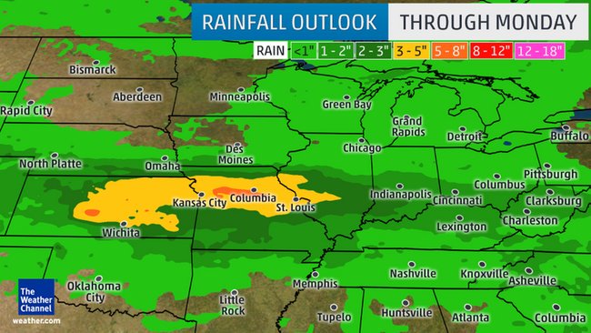
The threat for heavy rain and flooding returns to the Plains into the Fourth of July weekend, and the rain could spread eastward and affect flood-ravaged West Virginia by Monday.
The National Weather Service has already hoisted flash flood watches in parts of the central Plains, including the Kansas City metro area.

Current Flood Alerts
Some severe thunderstorms are possible late this week, but with a stalling frontal boundary over the Plains, the main focus will be heavy rain this weekend into early next week.
Showers and thunderstorms will form along the stalled front each day, so the position of the front is key to where the heaviest rain sets up.

Heavy Rainfall Setup
(MORE: View National Interactive Radar Map | Difference Between a Watch and a Warning)
During the Fourth of July weekend, parts of Kansas, Missouri and southern Illinois are the main areas at risk for heavy rain and flash flooding, though some thunderstorm clusters may also affect parts of neighboring states, as well.
(MORE: Why Summer's Thunderstorm Clusters are Both Important and Dangerous
By Sunday and Sunday night, the flood threat begins to spread eastward into parts of the Ohio Valley.
By the Fourth of July, the flood threat, unfortunately, sets up over the Mid-Atlantic, Appalachians and Ohio Valley, including West Virginia. This forecast will need to be monitored closely after the last week's third deadliest flood event in West Virginia's history.
(MORE: The Most Extreme Rainfall in All 50 States)

Rainfall Forecast
Keep in mind with any rainfall forecast that locally much higher amounts may occur over a much shorter period of time where bands of rain or thunderstorm clusters stall, with the potential for triggering dangerous flash flooding.
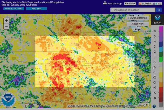
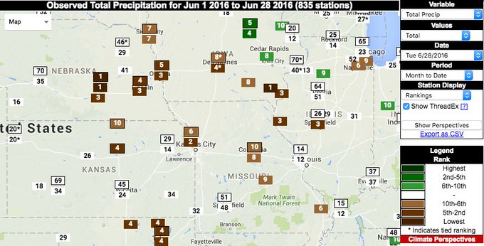
Interestingly, this part of the nation's heartland has been very dry in June. Some locations may end up with one of their top 10 driest Junes on record, according to the Southeast Regional Climate Center.
Grand Island, Nebraska, for instance, had only picked up a mere 0.05 inch of rain all month, through Wednesday, during what is typically the second wettest month of the year.Since this is a holiday weekend, travelers should be aware that flooding is a serious concern.
Weekend heavy rain threat targeting a recently dry area. Several cities in top 10 driest Junes, per @SERCC.

Since this is a holiday weekend, travelers should be aware that flooding is a serious concern.
(MORE: At Least 234 People Have Been Killed By Flooding in the U.S. in Nearly 18 Months)
If you plan on traveling along Interstate 70 between Denver and Kansas City or from St. Louis to Indianapolis, be mindful that flooding is a possibility along this major highway.
For travelers heading back home on Monday, Interstate 79 could potentially be impacted in West Virginia between Morgantown and Charleston.
According to FEMA:
- 6 inches of water will reach the bottom of most passenger cars, causing loss of control and potential stalling.
- 1 foot of water will float many vehicles.
- 2 feet of rushing water will carry away most vehicles, including SUVs and pickups.
(MORE: Your Vehicle Can Be a Deadly Trap in a Flash Flood

PHOTOS: Plains, Midwest Mid-June 2016 Severe Weather and Flooding

Your Vehicle Can Be a Trap: Many Have Tried to Cross Flooded Streets and Many Have Failed

Jonathan Belles
Published: June 30,2016

Numerous cars were swept off roads covered by floodwater in Texas during a siege of flooding in late May and early June.
jeep was swept away by floodwater in just minutes in New Braunfels, between San Antonio and Austin.
Later in the week, a truck was taken across the Brazos River as the driver attempted to cross the river. The passengers, including one canine friend, are safe, but the truck didn't make it.
(MORE: Fort Hood Soldiers Lose Their Lives In Floodwater)
In Granbury, southwest of Dallas, the Brazos River rose more than 15 feet in less than 12 hours during a crest. The river overflowed its banks again about 24-36 hours later, sweeping cars and debris down river as the it reached major flood stage.

We aren't learning our lesson

The single worst decision you can make in a flash flood is driving your vehicle into floodwaters of unknown depth.
An average of 82 people have died in the U.S. from flash floods each year from 2006-2015, according to the National Weather Service. That's more than double the average death toll from lightning.
In 2015, 155 people died from flooding, and it was the number one cause of weather-related fatalities in 2015.
Percent of flood-related deaths by situation from 1995-2010, excluding Hurricane Katrina flood deaths.
Almost two out of every three U.S. flash flood deaths from 1995-2010, excluding fatalities from Hurricane Katrina, occurred in vehicles, according to Dr. Greg Forbes, severe weather expert for The Weather Channel.
It's easy to misjudge the depth of floodwater, particularly at night. Sometimes the bridge or road masked by floodwater may have been undermined or completely washed out.
In some cases, the flash flood event occurs over such a localized area, say one part of one county or city, that driving conditions may go from dry roads to high water in a matter of a few miles or within minutes.
(EXAMPLE: Louisville Metro Flooding April 2015)
According to FEMA:
- 6 inches of water will reach the bottom of most passenger cars, causing loss of control and potential stalling.
- 1 foot of water will float many vehicles.
- 2 feet of rushing water will carry away most vehicles, including SUVs and pickups.
According to the U.S. Geological Survey, water 1 foot deep typically exerts 500 pounds of lateral force on a vehicle.
Once your vehicle is floating, the floodwater becomes your steering wheel. If that water is moving, your vehicle could be swept away, tipped on its side or flipped.
(MARIANA MENDEZ/AFP/Getty Images)
Rising water can enter your vehicle in a manner of minutes, even seconds.
The best advice we can give is to never drive through floodwater of unknown depth. As the National Weather Service has campaigned for years: "Turn around, don't drown!"
If you are stuck in your vehicle underwater, you need to act quickly:
- Find a pocket of trapped air, usually against the rear window or roof.
- Roll a window down slowly, take a deep breath and be ready to swim.
- If the window won't open, break the window with a rescue tool (Swiss Army knife, for example).

Don't Wade Through Floodwater, Either

If floodwater is powerful enough to float and/or trap your vehicle, trying to wade through it is also a bad idea.
Just 6 inches of flowing water can knock you off your feet. If you slip and fall face first, you might drown before you regain consciousness. This is particularly dangerous situation for babies and small children.
Flowing at just 6 mph, water exerts the same force per unit area as air blowing at EF5 tornado wind speeds, according to Dr. Forbes. Water moving at 25 mph has the pressure equivalent of wind blowing at 790 mph, faster than the speed of sound.
Forbes says the fastest floodwater speeds are thought to be around 67 mph, which may occur in steep, elevated terrain.
Not to mention, who knows what is flowing in the water besides you if you do decide to get in.

Your Responsibility: Be Aware

Awareness of the weather can save your life in a flash flood.
Download The Weather Channel's app for your smartphone and tablet or use NOAA Weather Radio to make sure you have a method of receiving flood watches and warnings.
Next time there is a risk of flash flooding, take it seriously. Stay out of the water. Don't become a statistic.
(MORE:  WeatherREADY flood tips | 6 Incredible U.S. Rain Records | 10 Wettest U.S. Cities)

MORE: Texas Flooding April 2016

Fourth of July Weekend Weather: Storms Possible in Mid-Atlantic, Southeast, Midwest

Brian Donegan
Published: June 30,2016

The Fourth of July weekend may be filled with stormy weather for parts of the mid-Atlantic, Southeast and Midwest, which could impact your outdoor plans, including fireworks. Meanwhile, the heat will be the story for much of the West. In the Northeast, temperatures will be close to seasonal averages and conditions are expected to be mainly dry.
(MORE: 10-day Planner Maps)
The overall weather pattern throughout the holiday weekend will feature a ridge of high pressure, or a bulge in the jet stream, over the West and a trough of low pressure, a southward dip in the jet stream, in the Northeast.

Saturday's Jet Stream Forecast
The result of this pattern is continued heat in the West, but it prevents any persistent heat in the East as frequent cold fronts will continue to move through. This will allow for comfortable temperatures and humidity levels in the Northeast for the holiday weekend.
Here's what you can expect for your holiday weekend plans:

Saturday


East Forecast for 4th of July Weekend
Overview
  • Wet areas: Scattered showers and thunderstorms are possible from the central and northern Plains to the Tennessee Valley, as well as portions of the southern mid-Atlantic, northern New England and Southeast. A few thunderstorms will also develop in parts of the Southwest and into the Rockies.
  • Dry areas: Much of the Northeast, southern Plains and West coast will enjoy dry conditions. Keep in mind, however, that the Northeast will be quite breezy, so you may need something to weigh down those table cloths on your picnic tables.
  • High temperatures: Highs will be in the 80s and 90s in the East. However, parts of New England, the Great Lakes region and the Midwest may see temperatures hold in the 70s. Parts of the West will soar into the 90s and even 100s in the Desert Southwest. Coastal areas of the West will see highs mainly in the 70s.
(FORECAST: New York | Miami | St. Louis | Denver | Los Angeles)

Sunday


West Forecast for 4th of July Weekend
Overview
  • Wet areas: Parts of the mid-Mississippi Valley to the Southeast run the risk for scattered showers and thunderstorms, as will portions of the mid-Atlantic. A few isolated showers and thunderstorms may also develop in the Plains and Four Corners region.
  • Dry areas: Much of the Northeast, Upper Midwest and West will all enjoy sunshine and dry weather.
  • High temperatures: Highs will be in the 80s across a large swath of the country. Portions of the Midwest and central Plains will hold in the 70s, while 90s and 100s are likely across the South and much of the West. Coastal areas of the West will once again see highs in the 70s.
(FORECAST: Boston | Nashville | Chicago | Las Vegas | Seattle)

Fourth of July (Monday)


Fourth of July Forecast
Overview
  • Wet areas: The Southeast, mid-Atlantic, Ohio Valley and parts of the Midwest will see the threat for scattered showers and thunderstorms. Isolated showers and thunderstorms are also possible in portions of the Plains.
  • Dry areas: The Northeast and much of the West will all enjoy sunshine and dry weather.
  • High temperatures: Highs mostly in the 80s are expected across the Northeast and Midwest, while the Southeast will reach the 90s. The Plains will see temperatures climb into the 80s and 90s, with a few 100s in Texas. Much of the West will be in the 90s, with 100s in the Desert Southwest, and along the coast and in the higher elevations high temperatures will be mainly in the 70s.
(FORECAST: Washington, D.C. | Atlanta | Dallas | Minneapolis | San Francisco)

Stunning Jupiter Auroras Captured by Hubble Space Telescope

Eric Chaney and Chris Dolce
Published: June 30,2016

Stunning new images from the Hubble Space Telescope are giving us a jaw-dropping look at auroras on the planet Jupiter, just days before NASA's Juno spacecraft reaches the planet's orbit for a year-long mission.
The massive auroras appear to be at least twice the size of the planet's famous Great Red Spot, a gigantic swirling storm that is itself twice as wide as the Earth.
The auroras were spotted using the Hubble's ultraviolet capabilities, said NASA's Goddard Space Flight Center, which released the images on Thursday through their Instagram account.

(NASA)


“These auroras are very dramatic and among the most active I have ever seen,” Jonathan Nichols from the University of Leicester, lead astronomer on the aurora study, said in a Hubble press release. “It almost seems as if Jupiter is throwing a firework party for the imminent arrival of Juno,” Nichols said.
Jupiter’s auroras were first discovered by the Voyager 1 spacecraft in 1979. A thin ring of light on Jupiter's nightside looked like a stretched-out version of our own auroras on Earth. Only later was it discovered that the auroras were best visible in the ultraviolet, the release says.
(MORE: Stunning New Maps of Jupiter Reveal Planet’s Turbulent Weather in Infrared)
Aurora's on Jupiter are created the same way they are on Earth, when high energy particles enter a planet’s atmosphere near its magnetic poles and collide with atoms of gas. But unlike auroras on Earth, those on Jupiter, which are hundreds of times more energetic, never cease.
Hubble's observations of the auroras are perfectly timed to collaborate with the Juno Space probe, which will spend nearly a year circling Jupiter's poles and peering through clouds to scrutinize the planet's southern and northern lights. It's the "perfect collaboration between a telescope and a space probe," the Hubble release says.
MORE: Amazing Exoplanets in Our Universe

A Very-Good-News Story: Microbursts and U.S. Aviation

By: Bob Henson , 4:14PM,GMT on June 30,2016


If you’re one of the millions of Americans who plan to take at least one flight this summer, take heart: you are remarkably well protected from weather during your flight, especially considering the risks that U.S. passengers faced not that long ago. From the 1970s to the 1990s, more than 800 fliers perished in U.S. commercial airline crashes that were linked to microbursts, small but intense downdrafts generated by thunderstorms. It took years of persistence from scientists to raise awareness of the issue and solve the problem. But solve it they did, by developing warning systems that took advantage of Doppler radar, surface wind sensors, and sophisticated software. Thanks to these systems, the last fatal crash of a U.S. passenger plane attributed to a microburst was on July 2, 1994, when a US Airways flight crashed near the Charlotte-Douglas International Airport, killing 37. As of this weekend, we’ll have put that disaster 22 years behind us.


Figure 1. A microburst emerges from a thunderstorm downdraft. Image credit: NWS/Birmingham, AL.


Figure 2. Depending on the amount of moisture in a thunderstorm and its environment, a microburst may be “dry” (left) or “wet” (right). Both types can be dangerous to aircraft. A video by photographer Brian Snider shows the formation of a dramatic wet microburst near Tucson in August 2015. Image credit: NOAA.

A stealthy villain
Microbursts emerged as a major threat when the mid-century boom in consumer aviation put thousands more flights aloft. It was in the 1970s that the eminent storm researcher T. Theodore Fujita analyzed the risk from localized downdrafts related to convection (showers and thunderstorms). First trained as a mechanical engineer, Fujita took a research flight in 1945 over the debris left by the bombs that struck Hiroshima and Nagasaki and observed starburst damage patterns emanating outward from the point of the bomb impact. Later, while surveying damage from the Super Outbreak of tornadoes of April 3, 1974, Fujita recognized similar starburst patterns, and he concluded that some of the damage must have resulted from descending wind bursts.

The next year, an Eastern Airlines flight crashed while landing at John F. Kennedy International Airport in New York on June 24, 1975, killing 113. Fujita was enlisted to help analyze the disaster. In a 1976 report, he remarked on “four to five cells of intense downdrafts which are to be called ‘downburst cells’. Apparently, those aircraft which flew through the cells encountered considerable difficulties in landing, while others landed between the cells without even noticing the danger areas on both sides of the approach path.” Fujita estimated that the peak downdraft speed several hundred feet above ground was up to eight times higher than conventional thinking would have predicted. Alas, he added, “there is no way of predicting the occurrence of these phenomena both in time and space.”

Even with very limited data, Fujita’s legendary analytic skills enabled him to see the core process at work: “In general, the air near the ground spreads out violently from the ‘outburst center,’ the spreading center above the ground. Unless a heading correction is made immediately, an aircraft in the crosswind burst will drift away from its expected course. If an aircraft flies straight into the outburst center, its indicated airspeed will increase momentarily followed by a high rate of sink. Before the aircraft can break out of the downburst cell, its indicated air speed will drop suddenly, due to an increase in the tailwind component.”


Figure 3. Diagram showing how a microburst could bring down an aircraft that flies directly through it. Modern warning systems now allow air traffic controllers to steer passenger planes safely around microbursts. Image credit: NCAR Research Applications Laboratory.

From dismissal to acceptance
Fujita’s ideas faced widespread skepticism, as noted by Josh Chamot (National Science Foundation, or NSF): “Until the mid-1970s, most researchers believed that downdrafts would substantially weaken before reaching the ground and not pose a threat to aircraft. They blamed tornadoes and gust fronts as the primary causes of storm damage.” After the JFK crash, the FAA developed a simple cluster of anemometers called LLWAS that could detect wind shear related to large-scale phenomena such as a frontal passage, but the LLWAS sensors were not close enough together to detect microbursts and other crucial small-scale features.

Meanwhile, Fujita and colleagues at the National Center for Atmospheric Research (NCAR) carried out several field campaigns with NSF support, designed to convince scientists and policymakers of the hazard and figure out how to address it. The first of these was Project NIMROD (Northern Illinois Meteorological Research on Downburst). On May 29, 1978, Fujita and NCAR’s James Wilson became the first scientists to detect a microburst on radar. “It was right on top of us,” Wilson told me in a 2010 interview. After this event, Fujita created a new category, microbursts, to denote downbursts less than 4 kilometers (2.5 miles) across.

Project NIMROD detected about 50 microbursts. A follow-up project in 1982, JAWS (Joint Airport Weather Studies) found dozens more near Denver’s now-defunct Stapleton International Airport. When JAWS kicked off its operations that summer, “the FAA was still not ready to admit there was such a thing as a microburst,” according to Wilson. But midway through the project, on July 9, 1982, a Pan Am aircraft was forced down by a microburst in a residential neighborhood in Kenner, Louisiana, killing all 145 people on board and 8 others on the ground. That calamity helped jump-start FAA funding for the remainder of the summer. The agency’s involvement in research accelerated further after a microburst-related 1985 Delta crash near Dallas-Fort Worth International Airport took 137 lives.


Figure 4. NCAR’s John McCarthy spent much of his time during the summers of 1984 and 1985 in the control tower of Denver’s Stapleton International Airport during the CLAWS project (Classify, Locate, Avoid Wind Shear). Image credit: UCAR.


Several more field projects followed, as did NCAR’s development of an enhanced version of the LLWAS system that’s now in place at more than 100 U.S. airports. NCAR and MIT’s Lincoln Laboratory also began collaborating with the FAA to develop a radar-based warning system called Terminal Doppler Weather Radar. TDWR systems were deployed at deployed at 45 U.S. airports in the late 1980s and 1990s, parallel with the NWS NEXRAD deployment. Along with the warning system, there was newfound pilot awareness of the wind shear hazard. All of the world’s commercial jet pilots were soon required to take part in a wind shear training program, and a powerful series of videotapes featured pilots sharing their stories of microburst encounters. Together, these innovations led to the essential vanquishing of microburst-related accidents on U.S. passenger planes since the mid-1990s.

Outside the U.S., “most international airports have no wind shear protection,” said Bruce Carmichael, director of NCAR’s Aviation Applications Program. “However, the new generation of aircraft radar systems include forward-looking wind shear warnings, so there is a good deal of capability inherent in the aircraft.”

In the realm of general aviation (all civilian flights outside of scheduled passenger service), wind shear remains a deadly threat, because most flights involve aircraft and airports that lack the means of detecting wind shear. Still, there is only an average of about 10 shear-related fatalities per year in U.S. general aviation, compared to the 400-plus general aviation deaths related to weather hazards as a whole.


Figure 5. An intense hailstorm bears down on the NWS NEXRAD radar located at Front Range Airport, just southeast of Denver International Airport, on May 21, 2014. A separate radar at DIA that focuses on smaller-scale phenomena is part of the FAA’s Terminal Doppler Weather Radar network. The storm was part of a multiday outbreak of severe weather from the Rockies to the Northeast U.S. (May 18-23) that caused $4 billion in damage. Image credit: Bob Henson.

Safer skies overall: just one fatal passenger crash in nearly a decade
Not only are U.S. airline passengers far safer from microbursts than they were decades ago, but they’ve been remarkably safe from other weather hazards—and just about all hazards, for that matter. On August 27, 2006, all 47 passengers aboard a Delta Connection flight were killed in a crash at the Lexington’s Blue Grass Airport near Lexington, KY, that was attributed to pilot error. Since then, there has only been one fatal accident on a U.S. passenger plane: a Continental Connection flight that crashed near Buffalo, NY, on February 12, 2009, killing all 45 passengers. This crash was also attributed to pilot error. For the nation to go nearly a decade with just one fatal accident on U.S. passenger planes would have been unthinkable as recently as the 1990s, when fatalities were a near-annual occurrence.

Americans are also much safer on the road: highway deaths are down by close to 20,000 per year compared to the 1970s and by about 10,000 per year compared to the 1990s. Unfortunately, a big spike occurred in 2015, when traffic deaths rose by an estimated 8% over the previous year, equating to some 2800 additional deaths. This was the largest year-over-year percentage increase in 50 years, according to the National Safety Council. While we don’t know exactly what caused this spike (increased traffic and growing phone-related distraction are possibilities), we do know that weather continues to be a major factor in highway safety. Roughly 3400 people are killed each year when driving in rain, and roughly 5700 on wet roads, according to the Federal Highway Administration.

The take-home message for travelers this summer: don’t worry too much about weather hazards if you’re a passenger on a commercial flight--but when you’re on the road, do everything that you can to drive safely and defensively, especially during adverse conditions. That text message can wait!

I'll be back with a new post by Friday afternoon, including updates on the tropical cyclone likely to form off the coast of Mexico in the next few days and the potential for very heavy rains across the Central Plains and Midwest into next week. PS: If you're hearing claims of "unprecedented" jet stream flow from the Northern to the Southern Hemisphere, check out the excellent debunking just published by Jason Samenow at Capital Weather Gang.

Bob Henson

Weather Underground National Forecast for Thursday,June 30,2016

By: nationalsummary , 10:00PM,GMT on June 29,2016


Weather Underground Forecast for Thursday,June 30,2016

A cold front will stall out over the Southeast on Thursday, while monsoonal thunderstorms persist across the Four Corners.

A cold frontal boundary will extend from the Mid-Atlantic to the southern Plains. This frontal boundary will continue to generate showers and thunderstorms across portions of the southern Mid-Atlantic, the Southeast and the Gulf Coast.

Another frontal system will dip south southeastward over the northern Plains and the upper Midwest. This cold front will initiate moderate to heavy rain and thunderstorms across the upper Intermountain West, the northern Plains, the central Plains, the upper Mississippi Valley and the upper Midwest. Prolonged heavy rain will bring threats of flash flooding to Kansas, northern Oklahoma, northwest Arkansas and southwest Missouri. Cool and dry air will settle in over the upper Midwest in the wake of the cold frontal passage.

Daytime heating and monsoonal moisture will lead to showers and thunderstorms across the Intermountain West and the eastern Great Basin. Locally heavy rain will be possible along favorable mountain slopes. Most areas across the West Coast will stay warm and dry on Thursday as high pressure builds over the eastern Pacific.

This Date in Weather History for June 30,2016 from weatherforyou.com

Weather History
For Thursday,June 30,2016


1886 - The second destructive hurricane in nine days hit the Apalachicola-Tallahassee area. (David Ludlum)
1942 - The temperature at Portland, OR, hit 102 degrees, an all-time record for that location. (The Weather Channel)
1972 - The entire state of Pennsylvania was declared a disaster area as a result of the catastrophic flooding caused by Hurricane Agnes, which claimed 48 lives, and caused 2.1 billion dollars damage. (The Weather Channel)
1987 - Hot weather prevailed in the Pacific Northwest, with readings above 100 degrees reported as far north as southern British Columbia. Yakima, WA, reported a record high of 100 degrees, while temperatures near the Washington coast hovered near 60 degrees all day. Thunderstorms prevailed from southwest Texas to New England. Thunderstorm winds gusting to 100 mph at Gettysburg, PA, killed one person. High winds and large hail caused more than five million dollars damage to property and crops in Lancaster County, PA. (The National Weather Summary) (Storm Data)
1988 - Thunderstorms in eastern Kansas drenched Worden with 12.21 inches of rain, and a wall of water two to four feet deep swept through Lone Star, KS, flooding every home in the town. Up to ten inches of rain was reported southeast of Callaway, NE. Thunderstorm winds gusted to 75 mph at Winfield, KS. Seventeen cities in the north central and northeastern U.S. reported record low temperatures for the date, including Duluth, MN, with a reading of 36 degrees. (The National Weather Summary) (Storm Data)
1989 - Winnfield, LA, reported 22.52 inches of rain in three days, and more than thirty inches for the month, a record for June. Shreveport LA received a record 17.11 inches in June, with a total for the first six months of the year of 45.55 inches. Thunderstorms also helped produce record rainfall totals for the month of June of 13.12 inches at Birmingham AL, 14.66 inches at Oklahoma City, OK, 17.41 inches at Tallahassee FL, 9.97 inches at Lynchburg, VA, and more than 10.25 inches at Pittsburgh, PA. Pittsburgh had also experienced a record wet month of May. (The National Weather Summary)

Wednesday, June 29, 2016

National Temperature and Rainfall Extremes for June 29,2016 from accuweather.com

As of 11PM,EDT/8PM,PDT


Daily U.S. Extremes

past 24 hours

  Extreme Location
High 121° Death Valley, CA
Low 34° Angel Fire, NM
Precip 2.24" Tallahassee, FL

New York City metro-area forecast for June 29-July 13,2016 from weather.com

Here's the 15-day weather forecast for the New York City metro-area for the period of the last 2 days of June and the first nearly 2 weeks of July (June 29-July 13),2016 from The Weather Channel's web-site;weather.com


Tonight,June 29-30: Becoming clear,but remaining seasonably warm for the end of June and the beginning of summer,with a low temperature dropping to the lower and middle 60's,overnight.As of 10:30PM,EDT,it's 72 degrees and clear,with 60% humidity,in White Plains,NY,and it's 78 degrees and clear with 47% humidity,in New York City.

Tomorrow,June 30: June of 2016 ends turning even warmer,as it turns quite warm to hot,with plenty of blazing sunshine and a high temperature of 85-90 degrees.

Tomorrow night,June 30-July 1: Remaining mainly clear,at least through the evening,then turning mostly cloudy with a chance for a stray shower or thunderstorm possible and a low temperature dropping to the middle and upper 60's,overnight.

Friday,July 1: July of 2016 begins turning mostly cloudy,rainy,stormy,and not as warm,with scattered afternoon thunderstorms,some of which could be strong to severe,and a high temperature of 80-85 degrees.Remaining partly to mostly cloudy,rainy,stormy,warm and humid with scattered evening thunderstorms,which could be strong to severe and a low temperature dropping to the middle 60's,once again,overnight.

Saturday,July 2: Becoming partly cloudy,but remaining seasonably warm for the beginning of July and very early summer,with a high temperature in the lower and middle 80's.Becoming clear and a bit cooler than recent nights,with a low temperature dropping to 60-65 degrees,overnight.

Sunday,July 3: Turning mostly sunny and warmer than recent days,with a high temperature of 85-90 degrees.Becoming partly cloudy,but remaining seasonably warm for the beginning of July,with a low temperature dropping to the middle 60's,overnight.

Monday,July 4: Independence Day (the Fourth of July),2016 will be remaining mostly sunny and quite warm for very early July and very early summer,with a high temperature of 85-90 degrees,once again;perfect weather for barbecues this afternoon and evening.Turning cloudy,but remaining seasonably warm and dry for the fireworks displays this evening,with a low temperature dropping to 65-70 degrees,overnight.

Tuesday,July 5: Remaining cloudy through the morning followed by partial afternoon clearing and a slight chance for a rain shower and a high temperature in the lower and middle 80's.Remaining mostly cloudy,rainy,warm and muggy,with evening rain showers followed by intermittent late-night rain showers and a low temperature dropping to 65-70 degrees,once again,overnight.

Wednesday,July 6: Turning hot,with a mix of blazing sunshine and some clouds and a high temperature in the upper 80's to lower 90's.Remaining warm with a few clouds and a low temperature dropping to the upper 60's to lower 70's,overnight.

Thursday,July 7: Remaining partly cloudy,but turning very hot for early July and early summer,with a high temperature of 90-95 degrees.Remaining warm with a few clouds and a low temperature dropping to around 70 degrees, overnight.

Friday,July 8: Becoming mainly sunny,but remaining hot,with a high temperature in the upper 80's to lower 90's.Becoming cloudy,rainy,stormy,warm and muggy,with scattered showers and thunderstorms possible and a low temperature dropping  to 65-70 degrees,overnight.

Saturday,July 9: Remaining quite warm to hot with mostly sunny skies and a high temperature of 85-90 degrees.Becoming partly cloudy through the evening followed by increasing cloudiness and a chance for a late-night rain shower and a low temperature dropping to the middle 60's,overnight.

Sunday,July 10: Remaining mostly sunny and quite warm for early July and early summer,with a high temperature of 85-90 degrees,once again.Becoming partly cloudy,but remaining seasonably warm for early summer,with a low temperature dropping to the middle 60's,once again,overnight.

Monday,July 11: Becoming partly cloudy,rainy,and stormy,with scattered afternoon thunderstorms and a high temperature in the middle and upper 80's.Remaining cloudy and rainy,with occasional rain and a low temperature dropping to the middle and upper 60's,overnight.

Tuesday,July 12: Becoming partly cloudy in the morning followed by increasing cloudiness and a chance for more afternoon rain showers and a high temperature of 85-90 degrees.Remaining cloudy, rainy,warm and muggy,with a low temperature dropping to 65-70 degrees,overnight.

Wednesday,July 13: Remaining quite warm and toasty with a mix of sunshine and a few clouds and a high temperature of 85-90 degrees,once again.Becoming mostly clear,but remaining seasonably warm for early-to-mid July,with a low temperature dropping to 65-70 degrees,once again,overnight.

Weekend showers across London to dampen Wimbledon, British Summer Time concert series

By Eric Leister, Meteorologist
June 29,2016; 10:10AM,EDT
 
 
Only one day since June 10 has been free of rainfall in Greater London, and that trend will continue through the upcoming weekend.
Showers are expected each day from Friday through Sunday across all of the United Kingdom. The greatest threat each day will be during the afternoon and evening around London.
The wet weather could impact outdoor events throughout the area including Wimbledon and British Summer Time at Hyde Park.

Any shower moving through Wimbledon during the matches will trigger a delay, according to AccuWeather Chief Video Meteorologist Bernie Rayno.
"Of all the [tennis court] surfaces, you cannot play on grass with any kind of rain, even if there is a brief shower," Rayno said. "The grass gets too slippery."
The roof of Centre Court can be closed and play can resume roughly 30-40 minutes after rain begins, according to Wimbledon's official website. The remainder of the 18 grass courts are open.

The unsettled weather pattern will continue next week with additional chances for delays.
The first weekend of the British Summer Time concert series at Hyde Park in London will take place Friday, Saturday and Sunday with performances by Massive Attack, Florence and the Machine and Carole King among others.
RELATED:
United Kingdom Weather Center
MinuteCast® for your location
Interactive United Kingdom weather radar

Anyone planning to attend the outdoor event will need to be prepared for both showers and occasional sunny spells.
Along with the threat for showers, gusty winds are expected each day. Sustained winds of 10-20 mph (16-32 kph) are likely with occasional gusts to 30 mph (50 kph).
High temperatures of 18-19 C (64-67 F) are forecast; however, these gusty winds combined with showers and clouds will make it feel several degrees cooler than the actual air temperature.

Germany: Dry end to the weekend in store following stormy Saturday

By Eric Leister, Meteorologist
June 29,2016; 8:46AM,EDT
 
 
A wet start to the weekend will give way to a pleasant day on Sunday, as drier air builds in from the west.
Rain will threaten to fall across all of Germany on Saturday as a cold front crosses the country.
This front will trigger scattered showers across western and central Germany, while parts of eastern Germany will be at risk for thunderstorms.

Areas from Stuttgart and Munich northeast to Dresden and Berlin will be at the greatest risk for downpours, which could threaten to cancel or delay outdoor events, especially during the afternoon.
Cool air arriving behind this front will make it feel more like late May than early July from Hamburg to Cologne and Frankfurt, with afternoon temperatures ranging from 16-20 C (60-68 F).
High pressure building in from the west will deliver drier air throughout Germany on Sunday, resulting in a pleasant day with seasonable temperatures and more sunshine.
RELATED:
Germany Weather Center
MinuteCast® for your location
Interactive Germany weather radar

Most areas can expect dry conditions throughout the day; however, there can be a few brief showers in far northern areas, including Bremen and Hamburg.
High temperatures will generally range from 18-22 C (65-72 F) with the warmest air expected in the south and east.
This dry and pleasant weather will continue for most areas on Monday, though there may be a few spotty showers across the northern tier of the country.

Fourth of July fireworks bans in effect across western US amid drought, wildfires

By Brett Rathbun, AccuWeather.com Meteorologist
June 29,2016; 8:30AM,EDT
 
 
Recent dry weather paired with the high risk for wildfires has led to firework bans for Fourth of July celebrations across the western United States.
Dry weather since April has caused the entire West Coast to return to conditions that are at least abnormally dry, according to the U.S. Drought Monitor.
"The recent dry weather coupled with dried out or dead vegetation leads to a scenario that will make the use of fireworks very dangerous over the upcoming holiday weekend," AccuWeather Meteorologist Dan Pydynowski said.
In Washington, numerous cities, including Seattle, Spokane and Olympia, have been issued a firework ban or restriction, according to the Fire Protection Bureau.
A fireworks ban means that the sale and/or discharge of fireworks is prohibited for a specified time period.
In Oregon, fireworks are not allowed along state beaches and at all state and national parks, according to The Oregonian.
In California, a ban is in place in the town of Salinas, according to KSBW as well as portions of Sacramento County, according to KCRA.
Fans at O.co Coliseum watch a fireworks show after a baseball game between the Oakland Athletics and the Seattle Mariners in Oakland, Calif., Friday, July 3,2015. (AP Photo/Jeff Chiu)
RELATED:
How the weather affects fireworks
America's best Fourth of July fireworks displays
US La Nina forecast: Drought to worsen across southwestern US

"Though cities such as San Francisco and Los Angeles only average under 2 inches of rain between April 1 and July 4, it has been dry even by their standards," Pydynowski said. "Los Angeles has only received about 25 percent of their normal rainfall while San Francisco has received under 50 percent."
Despite a record rainfall during the winter months, the Pacific Northwest has also been dry as of late.
"Even wetter places such as Seattle and Portland, Oregon, still have only received about 60 to 75 percent of their normal rainfall since April 1," Pydynowski said.
Those who disobey fireworks bans could face a harsh penalty from local police departments, including a fine or jail time.
Fireworks used in an unsafe area could easily spark a new wildfire. Even outdoor barbecues should be used with caution, especially when used over dry vegetation.
With dry, hot weather expected to continue, more bans could go into effect as the holiday approaches.

Storms may disrupt July Fourth celebrations in central, eastern US

June 29,2016; 8:03AM,EDT
 
 
Thunderstorms may disrupt July Fourth activities in parts of the central and eastern United States.
While daily afternoon thunderstorms are not uncommon for early July, storms may pack a punch in parts of the Plains, Midwestern, Southeastern and mid-Atlantic states on Independence Day.
Exactly which individual communities stand the best chance of getting hit hard by a big storm cannot be determined with reasonable certainty this far in advance.
However, the area of greatest concern for stormy weather on the Fourth of July will extend from Missouri to Virginia with the potential for showers and thunderstorms at any time and perhaps multiple times during the day and evening hours, according to AccuWeather Lead Storm Warning Meteorologist Eddie Walker.

"While most of the storms will not be severe, the strongest storms will have the potential to bring isolated wind gusts, torrential downpours, frequent lightning and perhaps some hail," Walker said.
The storms will move eastward in the swath from the central Plains to part of the mid-Atlantic coast and could bring enough rain in a few communities to cause flash flooding.
"There is the potential for 2-4 inches of rain to fall where the storms repeat," Walker said.
A small number of the strongest storms could down tree limbs and result in sporadic power outages.
It could rain often enough in this swath to rain out barbeques, disrupt 5k runs and delay fireworks.
Some of the storms will occur not only during the afternoon and early evening hours but also when fireworks and celebrations will be at their peak. Details on the timing of the storms may not be possible until that day, due to the particular weather pattern.
RELATED:
US interactive radar
AccuWeather MinuteCast® for your location
Dry weather to dominate July Fourth weekend from Chicago to NYC, Boston

The storms are forecast to erupt along a west to east temperature and humidity boundary with cool, dry air to the north and hot, humid air to the south. Meanwhile, high above the ground, a fast river of air, known as the jet stream, will be nearby and could add the extra ingredients to produce severe weather. Because of this, more than one storm can occur on the holiday.
South of the designated unsettled corridor, the storms will be much more spotty and will likely take up only an hour or two of the day, with a few exceptions.
People spending time outdoors are encouraged to keep an eye on the sky and periodically check AccuWeather MinuteCast® and look for severe weather bulletins through the holiday weekend. At the first rumble of thunder, get off the lake or beach and move indoors to eliminate the chance of being struck by lightning.

Dry weather to dominate July Fourth weekend from Chicago to NYC, Boston

By , AccuWeather.com Senior Meteorologist
June 29,2016; 8:01AM,EDT
 
While downpours could come calling at the start and finish of the July Fourth weekend in the northeastern United States, the vast majority of the time will be dry.
On Friday, a storm system moving from west to east may tug just enough moisture up from the Southern states to produce afternoon and evening thundershowers.

A reinforcing push of less humid air will take over on Saturday and hold through Sunday over the much of the region. At least partial sunshine is in the offing both days.
Very spotty and brief showers may dot northern New England and northeastern New York state on Saturday.
"Extreme heat and high humidity will be suppressed in most areas from the Great Lakes to the Northeast," according to AccuWeather Senior Meteorologist Kristina Pydynowski.

"In much of the Northeast, the start of the Fourth of July weekend will be noticeably different, compared to how the Memorial Day weekend began, when highs were in the 90s F," Pydynowski said.
The air will be noticeably cooler over the interior Northeast and around the Great Lakes, especially at night. Temperatures can slip into the 40s and lower 50s over the mountains. Folks camping out this weekend may want to pack a jacket for the evening and a blanket for the overnight hours. Daytime highs will be mainly in the 70s.
"Temperatures will be fairly typical along the Interstate 95 corridor for early July, where the weather will be warm enough for shorts and short sleeves," Pydynowski said.
Highs from Boston to New York City, Philadelphia, Baltimore, Washington, D.C., and Richmond, Virginia, will be in the 80s each day.
RELATED:
Northeastern US interactive radar
AccuWeather MinuteCast® for your location
Storms may disrupt July Fourth celebrations in parts of central, eastern US

Around the Great Lakes, three of the four days are likely to feature sunshine. Friday will be the the coolest day around Chicago, Detroit and Cleveland with highs in the 70s. Temperatures will gradually trend upward Saturday and Sunday.
In addition to the Great Lakes region, the sunniest places will be at the beach during Saturday and Sunday. An afternoon sea breeze will be light and highly localized in the mid-Atlantic, where those heading to the beach should not have to worry about their umbrella blowing away. However, a land breeze could be stiff enough to be an annoyance at times on Massachusetts and New Hampshire beaches. Surf temperatures range from near 60 along the New Hampshire coast to 75 in Virginia.
On July 4, showers and thunderstorms gathering over parts of the Ohio and Tennessee valleys will approach the mid-Atlantic.
Downpours could occur at any time in parts of West Virginia and Virginia during Monday. The rainfall could creep northward into portions of Maryland, Delaware, Pennsylvania and southern New Jersey later in the day and during the evening.
There is still the chance of salvaging a day at the beach in Delaware and New Jersey on Monday.
Rain and possible thunderstorms could cause trouble with planned fireworks displays during Monday evening in parts of the mid-Atlantic.
A slight northward shift in the moisture could bring downpours into Chicago, Detroit, Cleveland, Pittsburgh and Philadelphia during the Fourth of July. For now, it appears dry weather will hold in New York City.
The day and evening hours will remain dry and generally clear in New England, New York state and perhaps the northern parts of Pennsylvania and New Jersey on July 4.