Monday, August 31, 2015

Amazing Hurricane Hunter Photos Show Insides of Hurricane Ignacio's Eye

Chris Dolce
Published: August 31,2015

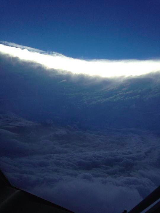
Hurricane Hunters investigating powerful Hurricane Ignacio east of Hawaii this weekend shared stunning photos and video from inside the storm's eye.
Ignacio reached its peak intensity as a Category 4 hurricane with 145 mph winds Saturday, making it one of three Category 4 hurricanes in the Pacific at that time.
(MORE: Three Category 4 Hurricanes Simultaneously)
The images show the stadium effect, which refers to how the inside of a well-defined eye can look like a bowl-shaped stadium. The towering clouds that make up the surrounding eyewall take on the role of stadium seating. The lower, clearer portion near the center of the eye is the playing field. While these features can be seen from space, it's a particularly impressive sight from Hurricane Hunter aircraft flying inside the eye and collecting data.
Inside the eye of Hurricane Ignacio. (Air Force Reserve 403rd Wing Hurricane Hunters)


Some of the most dramatic weather changes on Earth can occur a short distance near the eye of an intense hurricane.
Inside the eye, winds are mostly light. But lurking a short distance away lies the surrounding eyewall, where the most intense and destructive winds of a hurricane are found.
Hurricane eyes appear in various sizes and shapes. They can also vary in how they appear during the life of a hurricane. A great example is Hurricane Wilma in 2005, which had a tiny eye that was just two nautical miles wide when it was a Category 5 hurricane in the northwest Caribbean.
According to the National Hurricane Center, that tiny eye was replaced by another eye around a day later that was 40 nautical miles wide. The eye remained 40 to 60 nautical miles wide for the rest of Wilma's existence.
Inside the eye of Hurricane Ignacio. (Air Force Reserve 403rd Wing Hurricane Hunters)


Some hurricane eyes are clear enough that portions of the ocean surface may be visible from satellite images, while others are filled with clouds. A person on the ground in the middle of an eye could see blue skies during the day or stars at night if the eye is free of widespread clouds.
Dr. Matt Sitkowski of The Weather Channel explains why the eye of a hurricane can appear so clear at times: "In the eye, air sinks and warms. This warming helps to lower the storm's pressure and will also make the atmosphere more dry. This drying causes the clouds to evaporate, making the eye visible from space."
Sitkowski adds, "Hurricane Rita's eye was amazing. At around 10,000 feet, air that had descended from higher in the atmosphere warmed to 88 degrees and the dew point was only 27 degrees, making for an extremely dry eye. There were very few clouds in the center of the eye, so it remains one of the best examples of the stadium effect."
oRadar image from inside the eye of Hurricane Ignacio when the photos were taken. (Air Force Reserve 403rd Wing Hurricane Hunters)


MRE: Hurricane Eyes Up-Close

Remnants of Erika Continue to Bring Heavy Rain to Florida and Southeast

Jon Erdman
Published: August 31,2015


Despite Tropical Storm Erika's demise on Saturday morning, its remnant moisture is still bringing locally heavy rain to the Southeast U.S., including Florida, through early this week. Also playing a role in the threat for locally heavy rain in the Southeast is a southward dip in the jet stream over the region that is helping to transport moisture northward.
(RECAP: Tropical Storm Erika)

Regional Radar

Rainfall Outlook


It is difficult to pinpoint exactly which locations will see the heaviest rainfall, but a general swath from the Florida peninsula to the eastern Carolinas may see heavy rainfall at times into early Tuesday.
While this sounds like welcome news to parts of South Florida and the Deep South currently in drought, rain rates of several inches per hour in the heaviest rain clusters could quickly trigger flash flooding.
(FORECAST: Tampa | Orlando)
Slow-moving thunderstorms along the South Carolina coast on Monday morning resulted in flash flooding near the Charleston area. Water rescues and road closures were reported in the area and some homes and businesses had water entering them. The Charleston airport had seen 6.43 inches of rain on Monday through 10:00 a.m. EDT, making it the second wettest August day on record there. It's also the fifth wettest day of any month on record, there.
(MORE: Flooding Reported Near Charleston)
Parts of central Florida, particularly around the Tampa/St. Pete metro area, were soaked with heavy rain in recent weeks. Therefore, any clusters of heavy rain, there, would quickly trigger flash flooding and worsen existing river flooding.
In addition to the threat for heavy rainfall, a moderate risk of life-threatening rip currents continues from the east coast of Florida to North Carolina.
About 5 inches of rain was measured in southeast Florida near Cooper City and Weston in the 24 hours ending 11 a.m. EDT Sunday and near St. Augustine, Florida, 4.3 inches of rain was reported on Sunday. Farther south, Miami recorded just under 3 inches of rain over the weekend. In addition, a thunderstorm wind gust of 51 mph was reported northwest of Key West at Smith Shoal Light.
(MORE: Could Erika Quench Three Droughts?)
Street flooding was also reported due to the heavy rainfall in Gainesville, Florida as well as near St. Augustine on Sunday evening.

Erika's Flooding History

Intense rainfall impacted the Dominican Republic on Friday, with a personal weather station in Barahona reporting over 24 inches of rain. That station also reported an astonishing 8.80 inches of rain in one hour from 8 p.m. to 9 p.m. Friday.
A band of torrential rain also resulted in deadly flash flooding on the island of Dominica in the Lesser Antilles, Thursday. Roads were washed out, homes were damaged and an airport flooded.
(MORE: Flooding Hits Dominica)
Canefield Airport near the capital of Roseau, Dominica, picked up 12.64 inches (322.4 millimeters) of rain in a 12-hour period ending just before 2 p.m. EDT Thursday.
Bands of locally heavy rain currently over Haiti will shift to parts of Cuba, Jamaica and the possibly the Bahamas by late-day Saturday.
Historically, some of the highest death tolls with Caribbean tropical cyclones have occurred in these situations.
The National Weather Service in San Juan, Puerto Rico, said some parts of the island had already picked up 3 to 4.5 inches of rainfall in Erika's rainbands as of early Friday morning.

MORE: Tropical Storm Erika (PHOTOS)

Hurricane Kilo a Major Hurricane in the Central Pacific Near International Dateline

August 31,2015
  • Kilo became a major hurricane Saturday afternoon, and remains a powerful hurricane near the International Dateline in the central Pacific Ocean.
  • At one point Saturday evening into Sunday morning, Kilo was one of three Category 4 hurricanes in the Pacific, joined by Jimena and Ignacio.
  • Kilo is forecast to remain a major hurricane as it curls northwest and then west-southwest.
  • Hurricane Kilo would be renamed "Typhoon Kilo" when it crosses the International Dateline (180 degrees longitude) early this week.
  • Kilo is not a threat to land.
(MORE: Expert Analysis | Hurricane Central)

Storm Information and Satellite

Projected Path


Hawaii in the Rearview Mirror

Despite Kilo's inability to organize last week, the large-scale circulation near Hawaii brought enhanced moisture to the Aloha State, leading to locally heavy rainfall.
Honolulu picked up 4.48 inches of rain from early last Sunday morning (Aug. 23) through early this past Tuesday morning (local time), resulting in some road flooding and road closures on Oahu, Maui and the Big Island. Rain rates of 3-4 inches per hour were estimated by radar early Tuesday morning approaching Kauai.
Thunderstorms over the islands produced up to an estimated 10,000 cloud-to-ground lightning strikes over a 24-hour period from midday last Sunday (Aug. 23) through midday last Monday (Aug. 24), according to the National Weather Service in Honolulu.
Honolulu's 3.53 inches on Aug. 24 was an all-time record for any August day, topping a 2.92-inch deluge from Aug. 4, 2004, and propelled the Hawaiian capital to its wettest month of August, besting that record which had stood since 1888 (4.47 inches).

MORE: Hurricane Iniki, 1992

Hurricane Jimena Has Begun to Weaken in the Eastern Pacific

August 31,2015

Highlights

  • Jimena strengthened into a Category 4 hurricane early Saturday morning and remained at that status as of Monday night.
  • Hurricane Jimena is located about 1,140 miles east of Hilo, Hawaii.
  • Jimena has begun to weaken but should remain a major hurricane (Category 3 or stronger) through at least Tuesday.
  • For now, this system is no threat to land the next five days as it tracks west-northwestward behind Ignacio.
  • At one point Saturday evening into Sunday morning, Jimena was one of three Category 4 equivalent hurricanes in the Pacific, joined by Kilo and Ignacio.
(MAP: Follow Hurricane Jimena with our new Interactive Storm Tracker)

Current Status

Forecast Track
MORE: Hurricane Satellite Imagery

Hurricane Ignacio Passing Well North of Hawaii

August 31,2015

Highlights:

  • Hurricane Ignacio was located roughly 365 miles east of Honolulu, Hawaii, as of 5 p.m. Monday evening, Hawaii time.
  • At one point Saturday evening into Sunday morning, Ignacio was one of three Category 4 hurricanes in the Pacific, joined by Kilo and Jimena.
  • The center of Ignacio will pass north of Hawaii through midweek.
  • The tropical storm watch has been discontinued for the Big Island of Hawaii and Maui County.
  • Dangerous surf and rip currents will affect the east and southeast facing shores of Hawaii through early week. High surf warnings and advisories have been issued by the National Weather Service.

Latest Storm Information


Ignacio reached its peak intensity as a Category 4 hurricane this past weekend and is now weakening.
(MAP: Follow Hurricane Ignacio with our new Interactive Storm Tracker)
The weakening trend will continue over the next few days as it moves north of the Hawaiian Islands and is due to an increase in wind shear and slightly cooler water temperatures. The increase in wind shear is thanks to the proximity of the subtropical jet over the Hawaiian Islands. As Ignacio gains latitude, it will likely face increased shear, which tends to push convection away from the center of tropical cyclones.

Another Hawaii Threat?

The tropical storm watch has been discontinued for the Big Island and Maui County.
Over the next few days, Ignacio will track northwest. Computer forecast models have been fairly consistent with a track north of the Hawaiian Islands through midweek.
However, some outer rainbands may produce locally heavy rainfall at least in the eastern Hawaiian Islands into Tuesday, particularly over mauka (mountain) locations.
Dangerous surf will propagate to the east and southeast facing shores of Hawaii, particularly the Big Island and Maui, early this week. High surf warnings are posted for the Hawaiian Islands as surf will increase to 10 to 15 feet on Tuesday.
(FORECAST: Hilo | Maui | Honolulu)
Several tropical systems have threatened Hawaii over the past few weeks, but most of them changed course and/or weakened before directly impacting the islands.
Climatologically speaking, virtually all hurricanes near the Hawaiian Islands since 1950 have approached from the southeast, south or southwest. Those approaching from the east tend to either weaken quickly or shift north of the islands. Iselle in 2014 was one notable exception, however.
(MORE: Hawaii's Hurricane History)

Projected Path
MORE: Hurricane Satellite Imagery

Tropical Depression Fourteen-E Has Formed in the Eastern Pacific

August 31,2015
Highlights
  • Tropical Depression Fourteen-E has formed in the Eastern Pacific and is located about 750 miles south-southwest of the southern tip of Baja California as of 11 p.m. EDT Monday.
  • This system is forecast to strengthen into Tropical Storm Kevin midweek as it moves to the west-northwest.
  • Tropical Depression Fourteen-E is no threat to land in the next few days, but some computer forecast models indicate that it may impact portions of Baja California this weekend.
(MORE: Expert Analysis | Hurricane Central)

Current Status
Tropical Depression Fourteen-E is currently tracking to the northwest but is expected to turn more toward the north and then recurve to the northeast as a mid-level ridge of high pressure that is located to the north of this system is expected to shift eastward over the next few days. This could bring impacts to parts of Baja California later this week.
This system is not in an ideal environment for strengthening due to southwesterly wind shear in the area and is currently not expected to reach hurricane status.

Projected path
Weakening will likely be occurring by the time it reaches the peninsula and Tropical Depression Fourteen-E is not expected to be a very strong system at this time. However, there are indications that moisture from this system will spread into the southwestern U.S. later this week and into this weekend.
Stay tuned to The Weather Channel and check back with weather.com for updates on this system.
MORE: Hurricane Satellite Imagery (PHOTOS)

Tropical Storm Fred Moving Through Cabo Verde; Tropical Storm Warning in Effect

AuAugust 31,2015

Highlights

  • Fred strengthened into hurricane in the far eastern Atlantic Ocean just off the coast of Africa early Monday morning and weakened into a tropical storm Monday night.
  • Tropical Storm Fred was located about 55 miles north-northeast of Santo Antao in the Cape Verde Islands as of Monday night. Top sustained winds are 70 mph.
  • Fred will continue to move through the Republic of Cabo Verde into early Tuesday morning. Strong winds and heavy rainfall will persist as Fred moves through.
  • A tropical storm warning has been issued for portions of Cabo Verde.
  • Fred will continue to weaken this week in the open Atlantic Ocean and is no threat to the Caribbean or the United States.
(MAP: Follow Hurricane Fred with our new Interactive Storm Tracker)

Current status

Fred Projected Path


Tropical Storm Fred was moving through the republic of Cabo Verde in the far eastern Atlantic Ocean off the west coast of Africa as of Monday night.
Fred will continue to impact the islands through early Tuesday morning.
A hurricane warning was issued for Cabo Verde by the Cabo Verde Meteorological Service and this may be the first hurricane warning on record issued for the islands. The hurricane warning was canceled on Monday night and a tropical storm warning was issued for portions of the islands.
Tropical storm conditions will persist across parts of Cabo Verde into early Tuesday. Tropical storm force winds extend out 80 miles from the center of Fred.
Rainfall accumulations of 4 to 6 inches are likely with up to 10 inches possible in spots, which could trigger life-threatening flash flooding and mudslides. Coastal flooding is an additional concern in areas of onshore winds.
After passing through Cabo Verde Islands, Fred will turn west-northwestward over the open Atlantic Ocean. Southwesterly winds aloft, stable air and cooler water temperatures should begin to weaken Fred later in the week.
There is no indication at this time that Fred will come anywhere near the Caribbean or North America based on the latest computer model guidance and the state of the atmosphere. In fact, Fred is forecast to weaken to a tropical depression and then a remnant low in about 4-5 days.

Rare Hurricane For Cape Verde Islands

Fred is just the fourth Atlantic named storm to form east of 19 degrees West longitude, the National Hurricane Center said in its advisory issued for the storm Sunday morning.
According to a blog from Bob Henson of wunderground.com, there is no reliable record of a hurricane ever making landfall in Cabo Verde. Henson said that an 1892 storm reportedly intensified into a hurricane while passing to the south of the northwest Cape Verde Islands. In 1998, Jeanne reached hurricane status while passing south of the islands by about 100 miles, Henson added.
The islands have seen deadly impacts from tropical storms. The deadliest was Tropical Storm Fran in 1984 whose heavy rains caused flooding that killed more than two dozen people, Henson said.
(MORE: Expert Analysis | Hurricane Central)

Watches and Warnings
MORE: Hurricane Strikes (PHOTOS)

UK Cool, at Times Unsettled Next Few Days

August 31,2015; 10:02PM,EDT
 
 
Cool and at times showery weather will hold sway over the United Kingdom for at least the next few days.
Even so, for the main population centers such as London, Birmingham and even Glasgow, it will be far from a washout with at least occasional sunny intervals daily.

Rain will tend to be short-lived, owing to scattered showery outbreaks.
In London, the temperature Tuesday will top narrowly shy of the normal high, which is 20 C. However, much of the week will see highs of 2-3 C below what is typical for early September.
Nighttimes, likewise, will be cool with readings well below 10 C on multiple nights virtually everywhere away from the coasts.
RELATED:
United Kingdom Weather Center
Detailed London Forecast
Check AccuWeather MinuteCast® for London

The cause of the cool stretch will be low pressure over southern Scandinavia together with stubborn high pressure centered west of the British Isles. This setup will be slow to break down, lasting perhaps through the first of next week.
 

Asia Fall Forecast 2015: El Nino to Boost West Pacific Typhoons, Intensify Drought From India to Indonesia

By , AccuWeather.com Senior Meteorologist
August 31,2015; 9:54PM,EDT
 
 
Typhoons and building drought will impact more than one billion people in southeastern Asia this fall.

JUMP TO: Number of Super Typhoons May Challenge Record | Monsoon to Wind Down Quickly; Drought to Spread from Papua New Guinea to India | Warmth in Store for Much of Asia
Typhoons will threaten areas from Japan and eastern China to the Philippines during part of the fall, while building drought can lead to hardship from central India to Indonesia.
Number of Super Typhoons May Challenge Record
The 2015 typhoon season is on pace to surpass average numbers, but could challenge the record number of super typhoons since 1959, due in a large part to El Niño.
El Niño is forecast to remain strong through the fall and will keep waters warmer than average in the part of the Pacific Ocean where tropical systems usually develop. The rising air in this region leads to a high probability of tropical system formation.
During 1965 and 1997 seasons, there were 11 super typhoons. AccuWeather meteorologists are forecasting nine super typhoons this year, which will be the third most active season on record. This number is up two from the May prediction, due to the high number of super typhoons thus far (six) with another possible before the end of August.

According to AccuWeather International Meteorologist Anthony Sagliani, "We could challenge the record of 11 super typhoons, if we have a very active late season this year."
Typhoon season lasts through the entire year with a tropical cyclone possible during any month, regardless of whether or not an El Niño is occurring.
"The quietest months tend to be from December through April, but this year we have a very good chance at remaining quite active through December," Sagliani said.
In terms of which areas are likely to be hit through the end of the year, all areas of the western Pacific basin have a threat for tropical cyclones to impact them. The areas of greatest concern will shift southward progressing through the fall and into the early winter.
RELATED:
Asia Weather Center
Drought to Plague India Despite Monsoon
Outlook Grim for India Drought Areas With Monsoon to Withdraw Faster

Some areas hit hard by typhoons thus far this season are likely to continue to be hit into the first part of the autumn season.
"The greatest threat in September and October will be across Taiwan, China, the Korean Peninsula and Japan," Sagliani said.
The Philippines have seen minimal activity through the middle of August this season, but that is likely to change later this fall.
"Once we get into November and December, the threat will shift into the Philippines due to disruptive winds aloft making the atmospheric environment too hostile for tropical cyclones farther north," Sagliani said.
The danger being while the Philippines have been spared during the summer months, all it takes is one major typhoon to make for a disastrous season.
Monsoon to Wind Down Quickly; Drought to Spread from Papua New Guinea to India
Just as El Niño will continue to bring a very active and high-ranking typhoon season, it will likely result in an earlier or faster-than-average shutdown of the monsoon.

According to AccuWeather Chief International Meteorologist Jason Nicholls, much of southeastern Pakistan and parts of northwestern and far-eastern India were spared a serious drought. However, in much of central and southern India as well as the upper part of the Ganges River basin, rainfall has slipped well-below average late in the summer.
"With the early retreat of the monsoon, the areas that are abnormally dry now will slip into drought conditions this fall," Nicholls said.
Waters remained very warm in the India Ocean, despite El Niño. A major pulse of tropical showers and thunderstorms in June, and a weaker pulse in July were largely responsible for the near- to slightly below-average rainfall in Pakistan to northwestern and far-eastern India.
Very little rainfall has occurred in a large part of southeastern Asia, due to a strong El Niño this summer.
In this June 29, 2015, photo, water buffaloes graze near a drought-damaged area, downstream from Lamtakong dam in Nakhon Ratchasima, Thailand. Portions of Thailand have been declared emergency disaster zones. In multiple countries in Southeast Asia, the current drought is the worst in decades. (AP Photo/Sakchai Lalit
"Drought building in part of Indo China, Malaysia and Indonesia will get worse this fall," Nicholls said.
The existing or building drought conditions could cut crop yields such as palm oil, millet, wheat and rice in some locations.
"While the monsoon will quickly retreat over much of southeastern Asia, an area where rain will become frequent is along the coast of southeastern China to northern Vietnam," Nicholls said. "Flooding could be a problem in this area."
Warmth in Store for Much of Asia
The vast majority of Asia will experience near- to above-average temperatures this fall, except for part of far-eastern Russia.
"The portion of far-eastern Russia that borders Mongolia and northeastern China may get colder faster than average this fall," Nicholls said. "Potentially, this could lead to a couple of snow events near the coast of far-eastern Russia to the mountains northern Japan late in the autumn."
A storm track will set up from the Mediterranean to central China during much of the autumn. This will lead to bouts of significant rainfall from Israel and Syria to northern India, northeastern Pakistan, Kyrgyzstan and southern Kazakhstan.
Several rounds of gusty winds with episodes of blowing dust will extend from northern Egypt and northern Saudi Arabia to Iraq, Iran and southern Afghanistan.
Areas from northernmost India to Nepal and south-central China will turn stormy, following dry conditions early on.
"Areas from the Caspian Sea through much of the Eastern Frontier of Russia will be warmer than average," Nicholls said. "The warmth will be due to an above-average number of sunny days, while rainfall should still be close to average in most locations, which tends to be lean to begin with."
Other than the high country of the Himalayas, there is another area in southern Asia that could get early season snow.
Toward the end of the autumn, as the storm track shifts there may be enough chilly air drawn in to support snow in eastern Turkey, mainly in the Caucasus Mountains.
In the western plains and the central plateau areas of Siberia, winter could get off to a slow start.
 

National Temperature and Rainfall Extremes for August 31,2015 from accuweather.com

As of 11PM,EDT/8PM,PDT


Daily U.S. Extremes

past 24 hours

  Extreme Location
High 112° Death Valley, CA
Low 26° Boca Reservoir, CA
Precip 6.43" Charleston, SC

Western Wildfires Update: Thousands Mourn Firefighters Killed in Washington Blaze

Associated Press
Published: August 31,2015

Several thousand people were on hand Sunday to honor three U.S. Forest Service firefighters who were killed while battling a massive blaze in Washington.
The memorial service for 20-year-old Tom Zbyszewski, 26-year-old Andrew Zajac, and 31-year-old Richard Wheeler was held in Wenatchee, about 90 miles south of Twisp, the eastern Washington town where they were killed Aug. 19 as flames overtook their vehicle.
"They dedicated their lives to protecting our national forests and the people in the communities surrounding them," Forest Service Chief Tom Tidwell said in a eulogy. "And for that we should be grateful."
(MORE: Air Quality Worse in Some Northwestern Towns Than Beijing)

Through the Fire Management Assistance Grant program, we continue to support firefighters working hard in Washington.
The memorial service for 20-year-old Tom Zbyszewski, 26-year-old Andrew Zajac, and 31-year-old Richard Wheeler took place in Wenatchee. That's about 90 miles south of where they died Aug. 19 near Twisp in eastern Washington when flames consumed their crashed vehicle.
More than 80 vehicles took part in a procession leading to the memorial service Sunday where more than 100 firefighters stood at attention. Dozens of civilians also took part, many holding U.S. flags and others with signs that said "You are heroes!"
Tom Zbyszewski followed in his father's footsteps as a firefighter. He was the youngest of the three who died, and a physics major at Whitman College with an acting bent. He was due to return to school in about a week.
"Tom was the light of my life," his father, Richard Zbyszewski, said in his eulogy. "My path I'm afraid will always be a little bit darker because I miss him so much."
(MORE: Strong Storms Batter Northwest, Killing 2)
Zajac was the son of a Methodist minister from Downers Grove, Illinois. He was in his second year as a professional wildland firefighter for the Forest Service and earned a master's degree in biology last year from the University of South Dakota. Zajac and his wife, Jenn, were married last year after hiking the 2,650-mile Pacific Coast Trail together in 2013.
Jenn, in a statement read by Zajec's mother, Mary, said, "Andrew was my calm and my strength; my belay (climbing) partner, my fishing buddy, my hiking companion, my love. Just under a year ago we made a promise until death do us part. I just never imaged it would come so soon. I'll miss him forever."
Wheeler, "Wheels" as his friends called him during their eulogies, was a fourth-generation firefighter as well as an avid fisherman, hiker and hunter.
This was Wheeler and his wife Celeste's second year living in Wenatchee after he graduated in 2013 from Grand Valley State University in Michigan. He was a seasonal worker with hopes of becoming a permanent wildland firefighter for the U.S. Forest Service.
Washington Gov. Jay Inslee was out of the country, so his wife, Trudi Inslee, presented each of the families with state flags. The families also received Forest Service flags, small statues, and a Pulaski, a firefighting tool still in use today but also heavy with symbolism. When a person becomes a wildland firefighter, they are said to "pick up the Pulaski."
"Without men like Tom and Richard and Andrew, we would not be able to protect and care for the lands they devoted their lives to," Tidwell said.
Daniel Lyon, who sustained burns on more than 60 percent of his body in the fire that killed the three firefighters, on Sunday remained in serious condition at Harborview Medical Center in Seattle, where he's had two successful burn surgeries. A spokeswoman said the 25-year-old is scheduled to undergo another operation this week.
Meanwhile, crews made gains on the state's largest wildfire ever recorded as some rain fell over the weekend in north-central Washington. The Okanogan Complex of fires has burned more than 475 square miles and is 25 percent contained.
More than 7.8 million acres have burned in wildfires this year, according to the National Interagency Fire Center. That's well above the 10-year average of about 5.47 million acres through Aug. 29.
There are currently dozens of large wildfires burning across the West; here's an update on a few of them.

Oregon

Firefighters on Sunday worked to stop the spread of a group of central Oregon wildfires that have grown to 159 square miles and destroyed two more homes and a guest house.
Firefighters built fire lines around the buildings and set up sprinklers but had to flee Saturday when winds gusted up to 50 mph and threatened their escape routes.
About 950 firefighters are battling the blazes that have previously destroyed more than three dozen homes in the area.
Some residents in the area have been told to evacuate and residents of the town of Prairie City have been told to be ready to evacuate.
Fire spokesman Damon Simmons says crews have better conditions Sunday and are trying to stop the flames from spreading to the north and northeast.

Idaho

Northern Idaho residents on Sunday have been told to be ready to flee from a wildfire burning on the Idaho-Washington state border.
The Bonner County Sheriff's Office expanded the alert for north of Idaho State Highway 57 to include the Nordman area.
A group of six fires burning mostly in Washington has consumed about 33 square miles. About 765 firefighters are assigned to the blazes. Fire managers say they are facing tough conditions with strong and shifting winds.
In west-central Idaho, a 76-square-mile fire two miles east of Riggins jumped the Salmon River. Some residents in the area have been told to evacuate and others have been told to be ready to leave.
More than 800 firefighters are battling that blaze that's burning through timber.

Alaska

Additional firefighting crews were expected to arrive Friday to help battle a wind-whipped wildfire that prompted evacuation orders for a small Kodiak Island community and destroyed a library and some other properties.
The fire erupted Thursday in Chiniak (chihn-ee-AHK'), which is about 10 miles southeast of Kodiak on the easternmost point of Kodiak Island. Kodiak Fire Chief Jim Mullican told KMXT radio the fire was burning out of control.
The cause of the blaze wasn't immediately clear. There also was no immediately reliable estimate for its size, Kodiak City Manager Aimee Kniaziowski told the station.
Police said the library had burned down and some properties had been destroyed.

Montana

Light rain dampened some wildfires in far western Montana on Sunday, while other fires closer to the central part of the state continued to spread and threaten rural residences.
After most fires grew on Saturday because of warm, windy conditions, Sunday's weather brought at least cooler temperatures across the state.
"We were hoping that today would not be so active and that's the way things have been working out," Brad Purdy, spokesman for a complex of fires burning in the Kootenai National Forest near the Idaho border, said Sunday afternoon.
Purdy said conditions improved so much on one fire burning south of Libby that fire managers on Sunday morning lifted an evacuation order issued the previous day for 28 rural residences outside the town.
Rain also calmed fires burning in Mineral and Missoula counties west of Missoula that had earlier destroyed five Forest Service structures.
To the north, a fire in the Flathead National Forest near Glacier National Park that forced the evacuation of the small community of Essex also was not as active Sunday, according to fire spokesman Ted Pettis.
"It behaved itself pretty well," Pettis said. "I drove through the fire area today and it was pretty calm. I didn't see any open flames. It was smoking in places."
In the western part of the state close to the Idaho border, a wildfire near Tarkio, Montana, that had grown to about 19 square miles slowed down on Sunday, spokeswoman Kim Smolt said.
"It hasn't grown much in a day and a half. It's just creeping along right now," Smolt said, noting that five U.S. Forest Service structures have been destroyed. There are no reports of injuries or deaths, she said.
About 300 people in the area have evacuated from their homes, Smolt said.

California

A stray shot at a Salinas firing range sparked a blaze that burned 48.8 acres and took dozens of firefighters to contain.
The Monterey County Herald reports that the fire began around 1 p.m. Sunday when a shooter at the Laguna Seca Rifle and Pistol Range accidentally shot a concrete culvert that diverts rainwater. A spark from the bullet ignited nearby grass.
Ten fire trucks, two air tankers, two helicopters, about 40 firefighters and two prison inmate crews responded to the blaze. It was extinguished after about an hour. There were no injuries and no structures were destroyed.
Officials say there will be no charges for the shooter or fines for the range, which will be taking out the concrete culvert.
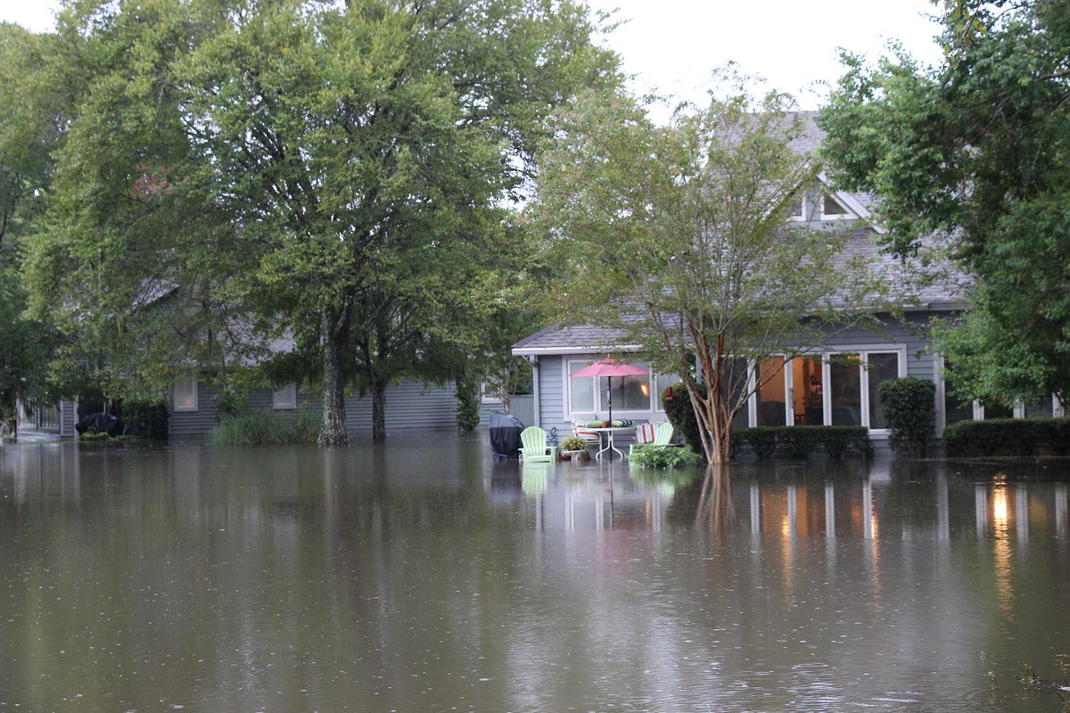
Flooding Rains Hit Charleston, South Carolina: Water Rescues, Small Mudslide Reported

Sean Breslin
Published: August 31,2015

Extremely high rainfall rates were reported in parts of Charleston, South Carolina, Monday morning, which led to flooding that rendered some roadways impassable.
The National Weather Service reported 6.25 inches of rain had fallen at Charleston International Airport between midnight and 8 a.m. EDT Monday morning, shattering the old daily record of 2.61 inches, achieved in 2006. It was already the second-wettest August day on record at the airport, which got more rain in under 8 hours than it had reported for the first 30 days of August, combined.
"A dip in the jet stream over the South is helping to send a pipeline of deep moisture from Florida northeastward to the coastal Carolinas," said weather.com meteorologist Chris Dolce. "This has contributed to the development of slow-moving thunderstorms this morning near the South Carolina coast that have unleashed torrential rainfall."
(MORE: Track the Storms As They Move Across the Southeast)
The flooding had negative impacts on travel Monday morning. Authorities were forced to close several roads that were under water, and the NWS reported a water rescue was in progress Monday morning in North Charleston.
Just before 8:30 a.m., a mudslide was reported by ABC News 4 near the intersection of Dorchester Road and Parmount Drive. One ramp was completely blocked, the report added.
All bus service was temporarily halted Monday morning due to the flooding but resumed shortly after.

Flooded condos in Shadowmoss.
Friend took this out front her home in Shawdowmoss

Police are responding to this mudslide in North Charleston. It's on Paramount Dr.... http://facebook.com/KyleJordanLive5News/posts/985413231481079 

Another factor was likely to worsen the flooding. High tide is expected at 9:42 a.m. EDT, WCSC-TV reported, and it's expected to be even higher due to a King Tide affecting the area for the next couple of days.
The remnants of Tropical Storm Erika continue to push north and won't help matters, either.
"Heavy rain could create additional flooding problems on Monday from the coastal Carolinas to Florida, where moisture from former Tropical Storm Erika will enhance rainfall," Dolce added.
MORE: Charleston Floods, Two Weeks Ago

Rare Hurricane Pounds Cape Verde Islands

By: Jeff Masters and Bob Henson , 4:23PM,GMT on August 31,2015


For the first time since 1892, a full-fledged hurricane is pounding the Cape Verde islands, as Hurricane Fred heads northwest at 12 mph through the islands in the far eastern North Atlantic. The eye of Fred passed just southwest of Boa Vista Island in the Republic of Cabo Verde (formerly called the Cape Verde Islands) near 8 am EDT Monday, with the northeastern eyewall likely hitting the island. The center of Fred is expected to pass over or very close to the northwestern Cape Verde islands of Sao Nicolou, Santa Luzuia, Sao Vicente, and Sao Antao by Monday night. All three reporting stations in the islands went off-line early Monday morning, so we have no observations to report. Despite their name (which translates to “green cape” in English), the Cape Verde islands have a semi-desert climate, with an average annual rainfall of only around 10 inches. The torrential rains of 4 - 6" predicted from Fred, with isolated totals of up to 10”, are likely to cause unprecedented flood damage on the islands. Fred may well turn out to be the Republic of Cabo Verde's most expensive natural disaster in history.


Figure 1. MODIS image of Hurricane Fred from NASA's Aqua satellite taken at approximately 8:15 am EDT Monday, August 31, 2015. At the time, Fred had top sustained winds of 80 mph. Image credit: NASA.

Most easterly hurricane formation location ever observed
Fred was able to form and intensify at an unusually easterly location, due to a pocket of anomalously warm waters (1-2°C above average, or about 27-28°C) that surround the Cape Verde islands. Since ocean temperatures are often just marginally warm enough to support tropical cyclones near the islands, it is rare to see a tropical storm or hurricane affect them. When Fred became a hurricane at 2 am EDT Monday at 22.5°W longitude, this was the easternmost formation location for any hurricane in the historical record; the previous record was held by Hurricane Three of 1900, which became a hurricane at 23°W, south of the Cape Verde islands. There have been six other hurricanes in the historical records that existed at a more easterly longitude, but all were recurving storms that formed much farther to the west than Fred. (The easternmost hurricane ever observed was Hurricane Faith of 1966, which maintained hurricane status to a position north of the British Isles, at 2.9°W.)


Figure 2. Tracks of all tropical cyclones in the vicinity of the Cape Verde islands from the NOAA historical database, which extends back to 1851 (although reports were scanty from the far eastern Atlantic until the satellite era began in the 1960s). Only a handful of tropical depressions (blue lines) and tropical storms (green lines) have affected the islands, and no direct hurricane landfalls (yellow lines) have been recorded. The two yellow tracks labeled above are an unnamed 1892 hurricane and 1998’s Hurricane Jeanne. When the National Hurricane Center named Fred at 5:00 am EDT Sunday, it was located at 18.9°W longitude; only three other named storms have existed at a more easterly longitude since hurricane records began in 1851. Ginger of 1967 at 18.1°W; Storm 3 of 1900 at 18.5°W; and Storm 6 of 1988 at 18.5°W. Image credit: NOAA Historical Hurricane Tracks.

A historic hurricane for the Cape Verdes?
The Atlantic's most terrifying and destructive hurricanes typically start as tropical waves that move off the coast of Africa and pass near the Cape Verde islands. This class of storms is referred to as "Cape Verde hurricanes", in reference to their origin. Despite the fact that the Atlantic's most feared type of hurricanes are named after the Cape Verde islands, the islands themselves rarely receive significant impacts from one of their namesake storms. This is because tropical waves coming off the coast of Africa have very little time to organize into tropical storms before arriving at the Cape Verde islands, which lie just 350 miles west of the African coast. There is no reliable record of any bona fide hurricane having made landfall on the Cape Verde islands (see Figure 2). The closest analogue for Fred is an 1892 storm that bisected the islands, moving between the northern cluster (Ilhas do Barlavento, or windward islands) and the southern cluster (Ilhas do Sotavento, or leeward islands). This 1892 storm reportedly intensified to hurricane strength while passing south of the northwestern Cape Verde islands. Another close approach came from 1998’s Hurricane Jeanne, which reached hurricane strength while passing about 100 miles south of the southern islands. Decaying tropical cyclones in the open Atlantic have occasionally circled southeastward to take a swipe at the Cape Verdes as extratropical storms, but none have reached the island at hurricane strength.

According to EM-DAT, the International Disaster Database, there have been only two deadly tropical cyclones in Cape Verde history. Like Jeanne, they both passed south of the Ilhas do Sotavento. The deadliest was Tropical Storm Fran of 1984, which brushed the southernmost islands on September 16 as a tropical storm with 50-mph winds. Fran brought sustained winds of 35 mph and torrential rains to the islands. The rains triggered flash flooding that killed more than two dozen people and caused damages of almost $3 million (1984 dollars.) The other deadly named storm was Tropical Storm Beryl of 1982, which passed about 30 miles south of the southwestern islands on August 29, with 45-mph winds. The storm's heavy rains killed three people on Brava Island, injured 122, and caused $3 million in damage.

The most recent named storm to affect the islands was Hurricane Humberto of 2013, which passed the islands to the south as a tropical storm. Humberto brought wind gusts of up to 35 mph and heavy rain squalls to the islands, triggering flooding that washed out roads and damaged homes. Hurricane Julia of 2010, the easternmost Category 4 hurricane ever recorded in the Atlantic, passed about 50 miles south of Sao Filipe, on the island of Fogo in the southern Cape Verde islands, as a tropical storm with 45 mph winds, bringing wind gusts of 30 mph and some minor flooding.


Figure 3. Track of Tropical Storm Fran of 1984, which brushed the southwestern Cape Verde islands on September 16 as a tropical storm with 50 mph winds. Torrential rains from Fran killed at least 29 people in the Cape Verde islands, making it the deadliest storm in their history.

Hurricane historian Mike Chenoweth, who has spent innumerable hours poring over dusty old ship logs, has published a number of histories of old hurricanes. Here are his comments on the history of hurricanes in the Cape Verde islands:

"There is very little data from land stations in the islands even for storms we know about that pass over or near the islands, particularly before the mid-20th century. The only hurricane in the HURDAT record (1892) is based on a single press account which does not specify any particular island that received the damage (it took a month for the news to get from the islands to Lisbon).

It is very likely that the storm history for the islands is under-estimated given the paucity of available land and ship data in existing data bases. For example, storm 2 of 1927 has a tropical storm passing between the islands (without a direct island landfall as in 1892) but there are no accounts of any effects the storm may have had on the islands. That such effects probably occurred but remain unrecovered is supported by the report of a hurricane near the Cape Verde islands reported by the "E.R. Sterling" which sailed from Port Adeliade, Australia on 16 April 1927 for London. The ship was damaged in a storm north of the Falkland Islands on 4 July and partially dismasted but continued northward. It then encountered a hurricane near the Cape Verde islands on 4 September and lost her foremast and the Chief Officer was killed. The ship was forced to put into St. Thomas, Virgin Islands on 15 October. So the storm was apparently stronger than indicated in HURDAT and may have been stronger in the Cape Verde islands as well. Source: http://www.dragonsearch.asn.au/nletters/MLSSA_NL_370_October_2009.htm.

In 1901, a storm was estimated to have passed south of the northern islands of the Cape Verde islands based on press accounts that I provided to the Best Track Change Committee. At the time there were no land reports from the islands in the map series or from press accounts. Today, I located a press item from the local Cape Verde press that indicates that on 29 August on Santo Antao two vessels were lost, much of the coffee and sugar cane was blown down and washed away and that mighty winds swept houses away and killed livestock and people. Most of the other islands reported at least torrential rains and flood damage. Source: "O Ultramarino" (Cidade de Praia), 17 de Outburo de 1901, nº 64, ano3, p. 2.

In 1880, the Bremen brig "Asante" encountered a tropical storm in 15.5N 20.2W on 17 August, lowest pressure 752.3mm (1003mb) maximum winds encountered force 11 from the south. (Deutsche Seewarte, Segelhandbuch für den Atlantischen Ozean, 1899, p.187). A brig drove off from her anchorage on the night of 17-18 August on the Island of Sal in the northeast Cape Verde islands during a "severe hurricane" and was lost on the island and the crew saved (Lloyd's List, 8 September 1880).

The most severe storm on record in the Cape Verde Republic's history pre-dates the official North Atlantic record. This was a hurricane and was felt on 2 September 1850. The first account of it was in the Boston Atlas of 3 December 1850 which reported a hurricane had caused great destruction of property; on the island of St. Antonio alone more than 600 houses were destroyed by the wind and rain combined; several American vessels were wrecked or damaged at the islands of Sal and Boa Vista. The London Times of 1 February 1851 had additional information. It stated that the storm on the island of San Nicolas was a "fearful hurricane" it began early in the morning before daylight and although it continued until the next morning, all of the damage was done in the first 3 or 4 hours, the wind blowing with such terrific violence during that short period that nearly all the crops and 600 houses were completely destroyed...the whole of the sattara root had been torn up and destroyed by the hurricane.

In short, the official records are incomplete and although hurricane impacts are rare in the Cape Verde Islands they are not quite the unicorns we have thought to date."


Figure 3. The view from inside the eye of Hurricane Ignacio on Sunday, August 30, 2015, from an Air Force hurricane hunter aircraft. At the time, Ignacio was a Category 4 storm with 140 mph winds. Image credit: Air Force Reserve 403rd Wing. There is also an impressive video from inside the eye on their Twitter page.

Ignacio no longer a threat to Hawaii; Pacific storm show goes on
In the Central Pacific, all watches and warnings have been dropped for Hawaii due to Hurricane Ignacio, which has weakened to Category 2 strength and is expected to skirt the islands over 300 miles to their northeast. Ignacio, will, however, bring dangerous high surf to the islands, and a High Surf Warning for waves of 12 - 20 feet along east shores of the Big Island has been posted. Impressive Category 4 Hurricane Jimena, and Category 4 Hurricane Kilo continue to put on a show over the open waters of the Eastern Pacific, but neither of these storms are a threat to land. All three hurricanes reached Category 4 strength on Saturday and remained there on Sunday morning, the first time since the satellite era began in the 1960s that three simultaneous Category 4 hurricanes had existed in the waters of the Eastern Pacific, east of the Date Line.

Links
Storm surge expert Hal Needham has a Monday morning post on the storm surge potential for Fred in the Cape Verde islands.

Live webcam from Sal Island in Cabo Verde.

We’ll be back with another update on Tuesday.

Jeff Masters and Bob Henson

Erika Unleashes Flooding Rain From Florida to Carolinas

By , AccuWeather.com Senior Meteorologist
August 31,2015; 11:01AM,EDT
 
 
The combination of Erika and a non-tropical system will drench areas from Florida to the Carolina coast through Tuesday.
Locally torrential downpours will bring the risk of flash and urban flooding in some communities from western Cuba to the Florida Peninsula, the eastern part of the Florida Panhandle, southeastern Georgia, central and southeastern South Carolina and part of eastern North Carolina.

Erika was shredded while trying to cross the large mountainous islands of Hispaniola and Cuba late last week and into Saturday, following significant damage and loss of life in the Caribbean.
Erika has been very difficult to pick out on satellite and radars to start the week. The leftover center appears to be just northwest of the Florida Keys.

According to AccuWeather Hurricane Expert Dan Kottlowski, Erika was downgraded to a tropical rainstorm over the weekend.
"The remnants of Erika will produce spotty flooding over the coastal sections of the southeastern United States as it drifts northward and merges with a non-tropical low pressure area," Kottlowski said.

Another 1-2 inches of rain are likely to fall in coastal areas of the Southeast states, with local amounts of 4 inches likely. The rainfall is likely to tend to focus along the west coast of Florida and the Carolina coast through Tuesday.
While the risk of gusty winds will be limited to locally strong thunderstorms, some communities could be hit with flash flooding with little notice due to the chaotic nature of the strung-out system.
In addition to the downpours and gusty winds, seas and surf can get rough in the vicinity of the strong thunderstorms. The pattern could produce a couple of waterspouts.
The bulk of the moisture will be pulled northeastward away from the Southeastern states later this week.
RELATED:
When the Next Hurricane Katrina Hits, Is the US Ready?
Hurricane Fred in Atlantic Not Expected to Threaten US
Hurricane Ignacio to Skirt Hawaiian Islands Early This Week

The weather should improve from Florida to the Carolinas. However, some moisture may be left behind in the form of spotty showers and thunderstorms. There is the potential for showers and thunderstorms to flare-up from time to time until any circulation from Erika is well inland.
Very warm and mainly rain-free conditions continue in the Northeast. An area of high pressure will block much of the remaining moisture from moving northward.
"There is a remote chance low pressure area near the Carolina coast may develop and take on tropical characteristics in the vicinity of Bermuda late this week or this weekend," Kottlowski said.

Rainfall Since Saturday Morning, Aug. 29, 2015

City
Rainfall (Inches)
Charleston, South Carolina
7.39
Mount Pleasant, South Carolina
4.22
Miami, Florida
3.55
Vero Beach, Florida
3.30
Homestead AFB, Florida
2.56
Savannah, Georgia
3.75
Elsewhere in the Atlantic, a tropical disturbance will move westward and cross the northern Caribbean but is not expected to develop this week.
Fred, near Africa, will move past the Cape Verde Islands and into the open waters of the Atlantic as the week progresses. Fred is not expected to threaten the U.S.

AccuWeather meteorologists Kristina Pydynowski and Alex Sosnowski contributed content to this story.

Texas Teen Dies After Contracting Brain-Eating Amoeba Linked to Warm Freshwater

By Katy Galimberti, AccuWeather.com Staff Writer
August 31,2015; 11:00AM,EDT
 
 
(Photo/CDC)
A 14-year-old boy from Texas died Sunday after contracting a brain-eating amoeba that thrives in warm freshwater.
Michael Riley, from Houston, went swimming with his school track team at Sam Houston State Park in mid-August, his family said in a statement on a Facebook page. After suffering from meningitis-like symptoms, Riley was taken to the hospital where doctors later confirmed it was a case of Naegleria fowleri.
Commonly found in warm freshwater such as lakes, ponds and hot springs, humans are infected by the deadly organisms when water containing the amoeba travels through the nose and migrates to the brain, destroying the tissue.
High temperatures in the summer months elevate the risk of coming into contact with the brain-eating amoeba.
A 14-year-old boy died after coming into contact with a brain-eating amoeba in a lake at Sam Houston National Forest. (Flickr Photo/CJ TravelTips)
Most infections occur during July, August and September when there is prolonged heat and thus higher water temperatures and lower water levels.
Cases of Naegleria fowleri are rare but deadly. After initial symptoms such as headaches, vomiting and fever, the disease progresses rapidly and in most cases causes death within three to 18 days, according to the Centers for Disease Control and Prevention.
RELATED:
Brain-Eating Amoeba Linked to Warm Water Kills California Woman
Third Louisiana Public Water Supply Site Tests Positive for Brain-Eating Amoeba
Storms Could Exacerbate Spread of Contaminants From Colorado Mine Spill

Riley's family said the amoeba likely entered his naval cavities as he jumped into the lake.
The family said the CDC flew an experimental drug to the Texas Children's Hospital from its Atlanta headquarters, but it proved unsuccessful for this case.
The young cross-country athlete was preparing to enter high school as a freshman this year.
Tips for Summer Swimmers From the CDC: Hold your nose shut, use nose clips or keep your head above water in warm bodies of freshwater.
Avoid digging in or stirring up the sediment while taking part in water-related activities in shallow, warm bodies of freshwater.
Avoid water-related activities in warm freshwater during periods of high water temperature and low water levels.
Do not put your head under water in hot springs.
 

Oppressive Heat Adds Stress to Physical, Mental Health of Homeless People From US to Canada This Summer

By Mark Leberfinger, AccuWeather.com Staff Writer
August 31,2015; 10:42AM,EDT
 
 
Hot weather this summer from the central United States into Canada has put extra stress on some of the most vulnerable residents: the homeless.
There has been an increase of clients using their services due to the higher-than-average temperatures, Homeless advocates from Houston, Texas, to Winnipeg, Manitoba, said.
Hot weather is a strong factor in driving more homeless to shelters than any other time of the year, according to Scott Arthur, director of public relations for the Star of Hope Mission in Houston.
In this Feb. 25, 2015 file photo, Giovanni and Michelle Griffie pose outside a wooden pod that was their home for a week in a downtown Tucson, Arizona, park before they got an apartment. (AP Photo/Astrid Galvan)
After starting out slowly in June with slightly below-average temperatures, Houston has had 10 100-degree-Fahrenheit days since July 1; seven of those days occurred in August.
"Men, women and families who usually live in abandoned buildings, old cars and street corners seek the cool and safety of our shelters," Arthur said. "Hot weather also sparks domestic violence, driving many women to our facilities as they escape their current situation."
Many of Houston's street homeless suffer from dehydration, Arthur said.
"This accelerates any existing mental challenges and causes some of our 'hard core' homeless to hibernate - away from society," he said.
RELATED:
AccuWeather.com Video Wall
Brett Anderson's Canada Weather Blog
2015 US Fall Forecast: Fire Danger to Worsen in West; September May Yield Tropical Impact in South

Water is the greatest need for the homeless because there is no reprieve in the heat, Judy Richichi, director of gifts and corporate relations for the Siloam Mission in Winnipeg told the Winnipeg Sun newspaper in mid-August.
Winnipeg experienced daytime highs between 86-94 F (30-34 C) between Aug. 11-15. The average high in Winnipeg for that time of year is 77 F (25 C).
As far as a limit for temperatures, anything above 90 F (32 C) starts to have a health effect on homeless people who have no access to air conditioning, AccuWeather Senior Meteorologist Jack Boston said.
"AccuWeather RealFeel® Temperatures, of course, give a good estimate on the effects of sunshine, wind and humidity in combination with the actual air temperatures," Boston said. "The effects of the heat are greater with the amount of sunshine, the higher the humidity and the lighter the winds are. A good rule of thumb for RealFeel Temperatures would probably be anything over 90 F (32 C)."
"Heat exhaustion comes from not only higher temperatures but also from dehydration," he said. "Sports drinks are formulated to stave off dehydration with the electrolytes they contain. Obviously, staying out of direct sunlight will also help, especially at lower humidity levels."
Hot and humid conditions affect infants and elderly people the most as well as those with respiratory issues such as COPD and emphysema, Boston said.

World Weather Hot Spot for August 31-September 1,2015 from accuweather.com

Zaltbommel,The Netherlands: Severe weather;hail more than 2 inches in diameter fell from a severe thunderstorm.

WeatherWhys for August 31,2015 from accuweather.com

The typical breeding grounds for Atlantic tropical cyclones continues to expand during the month of September as the ocean water temperatures reach their peak and the wind shear is weak.

New York City metro-area forecast for August 31-September 14,2015 from weather.com

Here's the 15-day weather forecast for the New York City metro-area for the period of the last day of August and the first 2 weeks of September (August 31-September 14),2015 from The Weather Channel's web-site,weather.com


Today,August 31: August of 2015 ends turning unseasonably hot and steamy for very late summer with a mix of clouds and sun and a record,or near record high temperature in the upper 80's to lower 90's.As of 12:15PM,EDT,it's partly cloudy and in the middle 80's,with 51% humidity,in White Plains,NY,and it's 84 degrees and partly cloudy,with 60% humidity making it feel like it's 86 degrees in New York City.

Tonight: Remaining partly cloudy and unseasonably very warm with a low temperature dropping to the upper 60's to lower 70's,overnight.

Tomorrow,September 1: September of 2015 begins turning sunny,but remaining unseasonably hot for very late summer with a record,or near record high temperature of 90-95 degrees.

Tomorrow night: Remaining unseasonably warm with a few late-night clouds and a low temperature dropping to the upper 60's to lower 70's,once again,overnight.

Wednesday,September 2: Remaining unseasonably very hot for the beginning of September,with a mix of sunshine and some clouds and a high temperature of 90-95 degrees,once again.Becoming mostly clear,but remaining very warm for very late summer with a low temperature dropping,for the third straight night,down to the upper 60's to lower 70's,overnight.

Thursday,September 3: Remaining mainly sunny and unseasonably quite hot for the beginning of September and the end of summer with a record high temperature in the sizzling middle 90's.Becoming partly cloudy,but remaining unseasonably warm with a low temperature dropping to around 70 degrees,overnight.

Friday,September 4: Not as hot,as it turns much cooler than recent days,but it'll still be quite warm for the end of summer and very early September,with generally sunny skies and a high temperature of 85-90 degrees.Becoming partly cloudy and much cooler than recent nights with a low temperature dropping to 60-65 degrees,overnight.

Saturday,September 5: Remaining unseasonably quite warm for early September and the end of summer with mostly sunny skies and a high temperature of 85-90 degrees.Remaining mostly clear and very warm for very early September with a low temperature dropping to 60-65 degrees,once again,overnight.

Sunday,September 6: Remaining unseasonably quite warm to hot for early September with sunshine mixing with some clouds and a record,or near record high temperature in the upper 80's to lower 90's.Becoming clear and a bit warmer than recent nights with a low temperature dropping to the middle 60's,overnight.

Monday,September 7: Labor Day 2015 will be turning sunny,but remaining unseasonably hot for early September and the end of summer with a record,or near record high temperature of 90-95 degrees.Becoming mostly clear and unseasonably warm with a low temperature dropping to 65-70 degrees,overnight.

Tuesday,September 8: Remaining unseasonably hot for early September and the end of summer with a few clouds from time-to-time and a record,or near record high temperature in the upper 80's to lower and middle 90's.Remaining mainly clear and warm with a low temperature dropping to the middle 60's,overnight.

Wednesday,September 9: Turning cooler than recent days,but remaining unseasonably very warm for early September and the end of summer with intervals of clouds and sunshine and a high temperature in the middle 80's.Becoming clear and cooler than recent nights with a low temperature dropping to the upper 50's to lower 60's,overnight.

Thursday,September 10: Becoming mostly sunny and much cooler than recent days,but remaining very warm for the end of summer,with a high temperature in the upper 70's to lower 80's.Remaining mainly clear and seasonably mild to warm for early September with a low temperature dropping to the upper 50's to lower 60's,once again,overnight.

Friday,September 11: The 14-year anniversary of the 9/11-terrorist attacks on the World Trade Center and the Pentagon will be turning partly cloudy,but remaining very warm for the end of summer with a high temperature in the upper 70's to lower 80's,once again.Remaining warm with a few clouds from time-to-time and a low temperature dropping,for the third straight night,down to the upper 50's to lower 60's,overnight.

Saturday,September 12: Remaining unseasonably warm for early-to-mid September with mostly sunny skies and a high temperature,for the third straight day,in the upper 70's to lower 80's.Becoming cloudy,rainy,and warm with rain showers at times and a low temperature dropping to 60-65 degrees, overnight.

Sunday,September 13: Turning cloudy and rainy,but remaining unseasonably warm for early-to-mid September with a chance for a morning shower or two followed by partly cloudy afternoon skies and a high temperature,for the fourth straight day,in the upper 70's to lower and middle 80's.Becoming partly cloudy,but remaining unseasonably warm for the end of summer with a low temperature dropping to 60-65 degrees,once again,overnight.

Monday,September 14: Becoming mostly sunny early,followed by increasing cloudiness and a chance for a few afternoon rain showers and a high temperature,for the fifth straight day,in the upper 70's to lower and middle 80's.Remaining cloudy through the evening with a chance for an evening rain shower followed by mostly clear late-night skies and a low temperature dropping to the upper 50's to lower 60's,overnight.