Published: March 22,2016
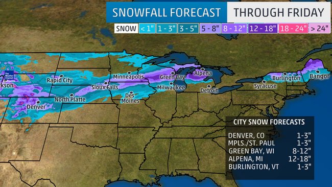
Winter Storm Selene is just getting started in the Rockies, and will spread an over 2,000-mile long swath of snow through Friday from the Rockies to the Upper Midwest, Great Lakes, and northern New England during the first full week of spring.
(MORE: Science Behind Naming Winter Storms)
The instigator for this early-spring winter storm is upper-level energy accompanying a southward dip in the jet stream that is currently pushing into the Northwest. Snow is likely in the West from the Cascades and the northern Sierra Nevada to the Rockies as the energy moves through into Tuesday night.

Current Radar
A narrow zone of sleet and freezing rain is also possible south of the snow swath from Wisconsin to northern New England.

Snow Setup This Week
(MORE: Severe Weather Threat This Week)
How Much Snow?
Our numerical forecast guidance is coming into better agreement on the placement of the snow swath in the Midwest that had been very uncertain in past days. However, small shifts in the forecast snow swaths could still mean big changes to locations on the snow swath's edge.Winter storm watches have been posted from parts of the Front Range of Colorado and southeast Wyoming to Michigan, and winter storm warnings are now posted in other parts of Wyoming and the mountains of northern Colorado.

Winter Alerts
- Over a foot of snow possible: Higher elevations of the northern Rockies from Montana to Idaho, Wyoming, Colorado and northern Utah; Locally, over a foot is possible from southeast Minnesota to northern Maine. (CITIES: Green Bay, Wisconsin | Alpena, Michigan)
- At least 6 inches of snow possible: Parts of the Front Range of the Rockies, western and northern Nebraska, the Black Hills and also parts of southeast South Dakota, northen Iowa, southern Minnesota, central and northern Wisconsin, northern Michigan, including the eastern Upper peninsula of Michigan, upstate New York, the Green and White Mountains, and parts of central Maine. (CITIES: Cheyenne, Wyoming | Denver | Minneapolis)
- Less than 6 inches of snow expected: Milwaukee | Des Moines | Duluth | Grand Rapids

Forecast Snowfall Through Friday
(INTERACTIVE: Commuter Forecast)
Winter Storm Selene Timing
Tuesday- Daytime: Snow is expected from the Cascades and the northern Sierra Nevada into the northern and central Rockies. Snow levels will fall to valley floors in some locations.
- Night: The northern and central Rockies will continue to see snow, while snow tapers off or ends in the Cascades and northern Sierra. Rain changing to snow also spreads into the High Plains, including eastern Wyoming, South Dakota and western Nebraska, along with increasing wind.

Tuesday's Forecast
- Daytime: A long swath of states from Wyoming and Colorado eastward to Michigan and Upstate New York could see snow or a rain/snow mix. In the Plains, any rain/snow mix will be changing to all snow.
- Night: Snow or rain changing to snow continues from parts of Nebraska and northern Kansas to Iowa, southern Minnesota, Wisconsin and Michigan. Some snow or a mixture of rain and snow may continue as far east as Upstate New York and northern New England.
- Gusty winds may accompany the snow leading to reduced visibility and treacherous travel conditions in the Upper Midwest and Plains.

Wednesday's Forecast
- Snow or a rain/snow mixture is expected from the upper Mississippi Valley and Great Lakes into Upstate New York and northern New England.
- Strong winds will continue to cause reduced visibility and hazardous travel conditions to the north and northwest of where the low tracks in the Midwest.
- Wintry weather may linger in northern New England into Friday.

Thursday's Forecast
(MORE: Where March and April are the Snowiest Months)
In fact, one-foot-plus March snowfalls are no stranger to the mythical "frozen tundra" of Green Bay, Wisconsin.
Green Bay, WI has had several 12"+ Mar. #snow events. Last one: 5 yrs before #Selene. http://wxch.nl/1RvRyWE #wiwx


No comments:
Post a Comment