A series of storm systems will continue to impact suddenly soggy parts of California and the Northwest into early in the coming week with heavy rain, feet of mountain snow, and gusty winds. After a recent storm produced destructive winds over 100 mph, another round of strong winds on Sunday may cause additional damage and power outages.

Current Radar and Winds
(MORE: What is an Atmospheric River?)

Moisture Pipeline Later This Week
(MORE: West Coast Impacts)
Below is a look at the forecast through this weekend for the storm parade taking aiming on the region.
Forecast Into This Weekend
Here is broad overview of the timing and impacts we can expect in California and the Northwest into the coming week.Timing:
- Into Saturday night: Another cold front impacts the Pacific Northwest and northern California with scattered showers, a few thunderstorms and mountain snow.
- Sunday into Monday: A potentially wetter and stronger storm pushing inland Sunday into Monday, impacting a swath from Washington to California.

Pacific Satellite
- Additional rainfall totals of 3 to 5 inches (locally higher) are expected in coastal ranges and foothills of northern California and southwest Oregon through this weekend.
- Additional heavy snowfall is expected from the central Sierra Nevada northward into Cascades. Snowfall totals will be measured in feet in the highest elevations of the Sierra.
- Depending on how persistent the rain is, flooding could become widespread. Significant rises on rivers and streams are also likely. The National Weather Service has issued flood watches for parts of northern California, including Sacramento, the Bay Area and Redding, as well as parts of western Oregon.
- Mudslides and rockslides are probable, and may become numerous, particularly near burn areas.
- Strong winds at times could down trees in some areas, particularly where soils are recently saturated or where trees have been weakened by the multi-year drought. High wind watches and warnings have been posted for portions of the Pacific Northwest, for Sunday, where locally damaging winds will be possible. Wind advisories have been issued for portions of California through early Saturday, including the San Francisco and Los Angeles metro areas.
- Our forecast rain and snow map through Monday illustrates the expectation of several inches of rain in the lower elevations and feet of snow in the mountains. The heaviest amounts are focused from northern and central California into the Northwest.

Rain and Snow Forecast Through Monday

Flood Alerts
Storm Reports Last Weekend-Monday
Rain, Flooding Reports:Saturday night into early Sunday morning, roads were flooded around San Jose and Oakland. Mudslides also created traffic issues, including in Santa Cruz where a mudslide and basketball sized boulders blocked a south bound lane on highway 17.
In central California, a few higher elevation locations of Contra Costa, Marin, Monterey, Napa, Santa Clara, Santa Cruz, San Mateo and Sonoma Counties picked up over 6 inches of rain in the 72 hours ending Monday morning. As much as 11.19 inches of rain fell near Loma Prieta in Santa Clara County. Lower elevations of the Bay Area picked up generally 1 to 3 inches of rain.
In far northwest California, 9.20 inches of rain was reported near Honeydew in Humboldt County as of early Monday morning.
Higher elevation locations in Southern California's Santa Barbara County had reported 4 to 5 inches of rain as of midday Monday. Parts of the Los Angeles metro area picked up more than an inch of rain.
Areas of heavy rain swept across central and southern California on Friday, including a half inch of rain in downtown Los Angeles and about a quarter of an inch in San Diego.
Wind Reports:
Winds gusted as high as 88 mph Saturday evening at Mount Diablo, with reports of scattered wind damage across Northern California that continued into Sunday. Trees were also downed in central California.
Thunderstorms brought strong winds to coastal portions of Southern California Monday morning which downed some trees, including in Los Angeles County.
Hurricane-force winds slammed the Pacific Northwest on Thursday, where gusts reached as high as 127 mph at Mission Ridge, 109 mph at Mount Baker and 101 mph at Crystal Mountain.
In California, non-thunderstorm wind gusts to 73 mph near Big Bear City and 68 mph at Volcan Mountain were reported Friday afternoon. A tree was uprooted near Anaheim on Friday, shattering the back window of an SUV.
Snow Reports:
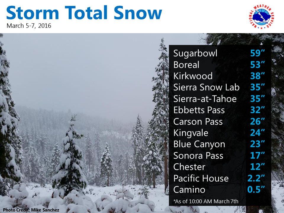
Up to 59 inches (nearly 5 feet) of snow was reported at Sugar Bowl Ski Resort March 5-7, 2016. Squaw Valley saw 48 inches of snow and Alpine Meadows Ski Resort picked up 41 inches of snow during the same three-day period.
Well look at that! Up to 5 feet of snow fell along the Sierra Crest from March 5-7. #cawx


No comments:
Post a Comment