The North Central Pacific (140°W to 180°) has been incredibly active
for tropical cyclone (TC) activity this year. The North Central Pacific
is part of the larger Northeast Pacific TC basin which extends from the
west coast of Mexico all the way to the International Date Line. When a
TC crosses 140°, the responsibility for issuing TC warnings gets
transferred from the National Hurricane Center to the Central Pacific
Hurricane Center in Honolulu, Hawaii.
Three Category 4 hurricanes in the Northeast Pacific (Kilo, Ignacio and Jimena) occurred at the same time last Saturday, August 29! This was the first time that three Category 4 TCs were present at the same time in any global TC basin, and both Kilo and Ignacio were in the North Central Pacific at the time. Never had two Cat. 3 hurricanes, let alone Cat. 4s ever been present in the North Central Pacific at the same time prior to this TC outbreak.

Figure 1: Satellite imagery showing three Cat. 4 hurricanes in the Northeast Pacific at the same time. From west to east, the three TCs are Kilo, Ignacio and Jimena.
In general, the North Central Pacific is considered to be a marginal basin for TC formation and intensification. The primary reason for this is due to strong vertical wind shear (the change in wind direction with height in the atmosphere) in the middle of the Pacific. Generally, vertical wind shear exceeding 15 knots is considered to impede TC development, and the average 1981-2010 July-August shear exceeds 15 knots throughout most of the North Central Pacific north of 10°N (where TCs typically track). For reference, 1 knot is about 1.15 miles per hour. Knots have a long history of being the wind units typically used in tropical meteorology.
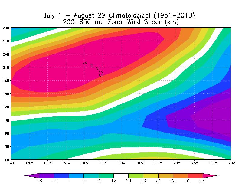
Figure 2: July 1 - August 29-averaged climatological 1981-2010 zonal wind shear across the North Central Pacific.
In 2015, however, the vertical wind shear has been reduced drastically, primarily due to El Niño. This has made the basin much more conducive for TC formation and intensification.

Figure 3: 2015 vertical wind shear anomalies across the North Central Pacific. The purple and blue colors indicate reduced levels of vertical wind shear.
In addition, sea surface temperatures (SSTs), the fuel for TCs, has been much higher than normal, due in large part to the strong El Niño currently present in the tropical Pacific.

Figure 4. SST anomalies across the tropical Pacific. Anomalies in the North Central Pacific are roughly 1-2°C warmer than normal.
Prior to 2015, the record for named TC formations in the North Central Pacific for an entire season was four set in 1982, while 2015 has already witnessed five TC formations (Halola, Ela, Iune, Kilo and Loke).
Most of the TCs that track through the North Central Pacific enter the basin from the east (as opposed to developing in the North Central Pacific itself), and 2015 has witnessed several TCs tracking into the North Central Pacific from the east. Hurricane Jimena is the sixth hurricane to either form in or track through the North Central Pacific this year, which breaks the record of five hurricanes through September 1 set in 1994.

Figure 5. Infrared satellite image of Hurricane Jimena on September 2.
One additional intensity metric that is frequently utilized to assess TC activity levels is Accumulated Cyclone Energy (ACE). ACE combines intensity, frequency and duration of TCs into one number. While 2015 has certainly been very active, it still pales in comparison to 1994 which generated nearly twice as much ACE through August as did 2015. Three Cat. 5 TCs (Emilia, Gilma and John) tracked through the North Central Pacific in July and August of 1994. However, 1994 generated very little ACE for the remainder of the TC season, so 2015 certainly has the potential to eclipse the ACE record set in 1994. For reference, the Atlantic typically generates about 100 ACE units in an average season, with about 30 ACE units generated by the end of August.
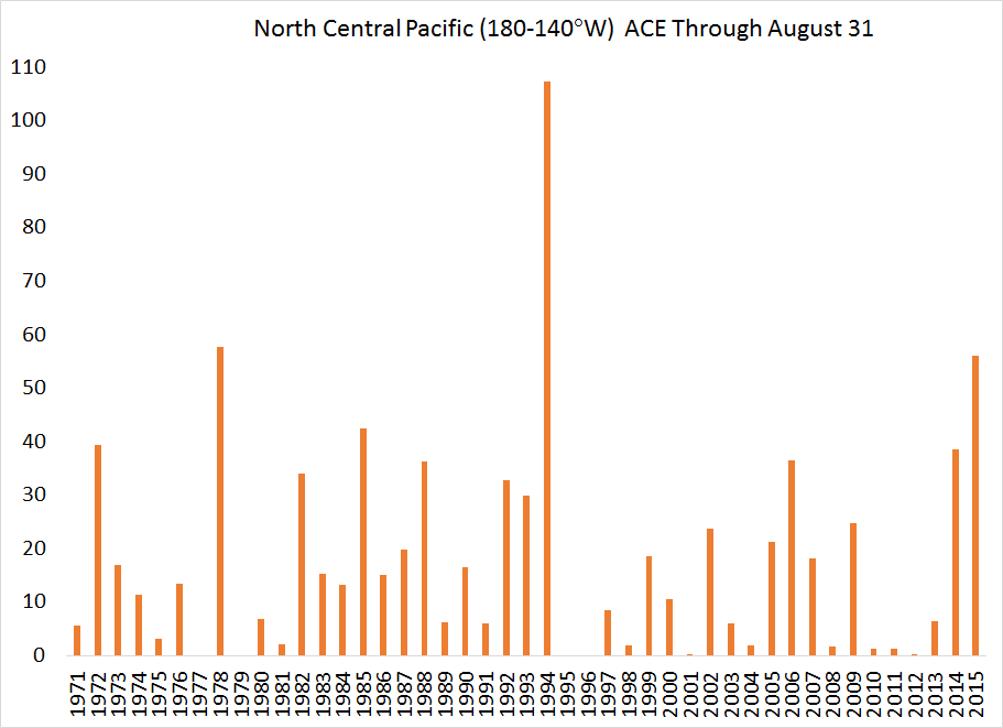
Figure 6. North Central Pacific ACE through August 31.
One unusual occurrence that only happens when conditions in the North Central Pacific are conducive for TCs is when a TC crosses the International Date Line. When it does so from the North Central Pacific into the Northwest Pacific, it retains the same name, but is referred to as a typhoon instead of a hurricane. With Kilo's crossing of the International Date Line (IDL) yesterday, 2015 now has the record with three IDL crossing storms in one year (Halola, Loke, and Kilo), breaking the old record of two set in 1997 (Oliwa and Paka).

Figure 7. Hurricane Kilo crossing the International Date Line on September 1.
Given the strong El Niño that is currently present, the North Central Pacific likely will have more activity during the remainder of 2015. It remains to be seen if it can break the all-time record for ACE set in 1994.
Three Category 4 hurricanes in the Northeast Pacific (Kilo, Ignacio and Jimena) occurred at the same time last Saturday, August 29! This was the first time that three Category 4 TCs were present at the same time in any global TC basin, and both Kilo and Ignacio were in the North Central Pacific at the time. Never had two Cat. 3 hurricanes, let alone Cat. 4s ever been present in the North Central Pacific at the same time prior to this TC outbreak.
Figure 1: Satellite imagery showing three Cat. 4 hurricanes in the Northeast Pacific at the same time. From west to east, the three TCs are Kilo, Ignacio and Jimena.
In general, the North Central Pacific is considered to be a marginal basin for TC formation and intensification. The primary reason for this is due to strong vertical wind shear (the change in wind direction with height in the atmosphere) in the middle of the Pacific. Generally, vertical wind shear exceeding 15 knots is considered to impede TC development, and the average 1981-2010 July-August shear exceeds 15 knots throughout most of the North Central Pacific north of 10°N (where TCs typically track). For reference, 1 knot is about 1.15 miles per hour. Knots have a long history of being the wind units typically used in tropical meteorology.
Figure 2: July 1 - August 29-averaged climatological 1981-2010 zonal wind shear across the North Central Pacific.
In 2015, however, the vertical wind shear has been reduced drastically, primarily due to El Niño. This has made the basin much more conducive for TC formation and intensification.
Figure 3: 2015 vertical wind shear anomalies across the North Central Pacific. The purple and blue colors indicate reduced levels of vertical wind shear.
In addition, sea surface temperatures (SSTs), the fuel for TCs, has been much higher than normal, due in large part to the strong El Niño currently present in the tropical Pacific.
Figure 4. SST anomalies across the tropical Pacific. Anomalies in the North Central Pacific are roughly 1-2°C warmer than normal.
Prior to 2015, the record for named TC formations in the North Central Pacific for an entire season was four set in 1982, while 2015 has already witnessed five TC formations (Halola, Ela, Iune, Kilo and Loke).
Most of the TCs that track through the North Central Pacific enter the basin from the east (as opposed to developing in the North Central Pacific itself), and 2015 has witnessed several TCs tracking into the North Central Pacific from the east. Hurricane Jimena is the sixth hurricane to either form in or track through the North Central Pacific this year, which breaks the record of five hurricanes through September 1 set in 1994.
Figure 5. Infrared satellite image of Hurricane Jimena on September 2.
One additional intensity metric that is frequently utilized to assess TC activity levels is Accumulated Cyclone Energy (ACE). ACE combines intensity, frequency and duration of TCs into one number. While 2015 has certainly been very active, it still pales in comparison to 1994 which generated nearly twice as much ACE through August as did 2015. Three Cat. 5 TCs (Emilia, Gilma and John) tracked through the North Central Pacific in July and August of 1994. However, 1994 generated very little ACE for the remainder of the TC season, so 2015 certainly has the potential to eclipse the ACE record set in 1994. For reference, the Atlantic typically generates about 100 ACE units in an average season, with about 30 ACE units generated by the end of August.
Figure 6. North Central Pacific ACE through August 31.
One unusual occurrence that only happens when conditions in the North Central Pacific are conducive for TCs is when a TC crosses the International Date Line. When it does so from the North Central Pacific into the Northwest Pacific, it retains the same name, but is referred to as a typhoon instead of a hurricane. With Kilo's crossing of the International Date Line (IDL) yesterday, 2015 now has the record with three IDL crossing storms in one year (Halola, Loke, and Kilo), breaking the old record of two set in 1997 (Oliwa and Paka).
Figure 7. Hurricane Kilo crossing the International Date Line on September 1.
Given the strong El Niño that is currently present, the North Central Pacific likely will have more activity during the remainder of 2015. It remains to be seen if it can break the all-time record for ACE set in 1994.
No comments:
Post a Comment