By Courtney Spamer, Meteorologist
September 16,2015; 10:20PM,EDT
The Western Pacific Ocean remains active as another typhoon emerges. However, this one will likely miss Japan, helping to avoid even more catastrophic flooding across the country.
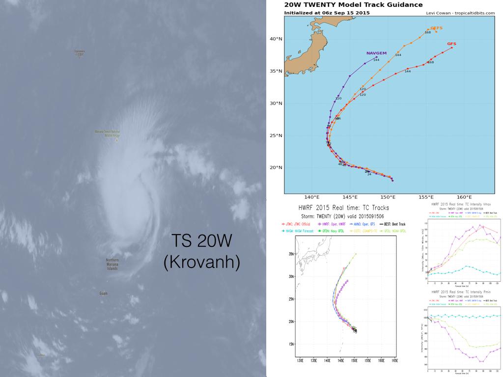
Late Tuesday night, local time, then-Tropical Depression 20W strengthened into a tropical storm, with wind speeds gusting to 83 km/h (52 mph). 20W, which eventually was named Krovanh, was about 450 miles northeast of Guam.
On early Thursday local time, Krovanh developed into a typhoon. Further strengthening is expected over the next day or two.

Luckily, the tropical cyclone will remain away from land, shifting its track from westerly to northwesterly. Helping to divert its track even more, a system crossing Japan throughout the week will help to steer Krovanh away from Japan.
"The projected path should keep the heaviest rain out of Japan," AccuWeather Senior Meteorologist Jason Nicholls said.
"This would be good news, considering the recent heavy rain and flooding from Etau," Nicholls added.
20W is now a TS (Krovanh). Still thankfully looks to pass east of Japan but can impact the Volcano Is around Fri.
Even though Etau, once a tropical storm, weakened after making landfall and crossing over southern Honshu last week, flooding rainfall continued for days. Persistent and heavy rainfall across central and northern parts of the island brought flooded streets in Joso, Japan, prompting evacuations and air rescues for those stranded on rooftops.
Following more than 250 mm (about 10 inches) of rain in just a few days last week, Tokyo and the suburbs to the north certainly would not welcome any more rain this month.
RELATED:
AccuWeather Japan Weather Radar
AccuWeather.com Tropical Homepage
Historic Flooding Strikes Japan in Wake of Etau
 Rainbow Satellite Imagery of Krovanh, (GIF/NOAA)
However, even the low pressure system moving from southwest to northeast across Japan will be bringing some showers throughout the end of the week. Although it will likely bring less rain than a direct hit by a tropical storm or typhoon, there could still be heavy rain. Heaviest rainfall amounts are expected along the southeastern coasts of Kyushu and Shikoku, before shifting across central Honshu and the eastern coastlines by Friday.
"The rain from this system would make more rain from a tropical system even more disastrous," Nicholls said.
A shift in Krovanh's path, even just a bit closer to Japan, could allow the steering low to absorb the tropical moisture before moving away from the islands.
AccuWeather meteorologists will continue to monitor this system as it strengthens throughout the week for changes in path and intensity.


No comments:
Post a Comment