Zachary Labe
3 September 2015
http://sites.uci.edu/zlabe/blog/
Welcome to sunny, southern California. Today's weather forecast: morning clouds, afternoon sun, and a high near 77°F. Pretty monotonous. Occasionally, the temperature will rise a bit higher or the low clouds from the marine may translate to fog, but that is about it. However, changes will be brewing across the area as we dive deeper into the fall season.
Local and national media outlets are filled with our Godzilla El Nino and other buzzwords to describe the continuously warming equatorial Pacific Ocean.

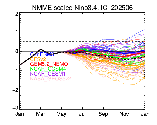
Sea surface temperature (SST) anomalies are forecast to reach near record high levels during the month of September and possibly surpass other strong El Ninos (e.g., 1982-1983 and 1997-1998). NMME/CFS and other long range forecast ensembles are maintaining a peak for this strong El Nino sometime during the early winter period. We later see a quick cooling of SSTs and a more likely than not reversal pattern into a La Nina state by mid to late 2016. These swings are very common after preceding strong +ENSO events.
A fair amount has already been said by the meteorological community concerning the strength of this ENSO event. I think, however, it is worthwhile to again note the extent of the warmer than normal SSTs across both the Pacific and Atlantic. These factors will play a key role in the upcoming winter.

We already know the stereotypical effects of El Nino events on the United States... just look up any map of the 1997-1998 event and there you go. But more wisely, we know that each ENSO event causes vastly different synoptic weather patterns.
It is likely we see the predominant forcing from the equatorial Pacific over the next few months with an amplified Rossby wave pattern dipping south into the midlatitudes. This will allow for an active subtropical jet increasing the probably for storm systems to move into southern California and across the southeastern CONUS before moving northeast.
While subsequent warmer than normal SSTs in the Gulf of Alaska can increase the probability of a -EPO and hence ridge/trough structure over the CONUS, we have been seeing a cooling trend in their anomalies over the last few weeks on the order of 1-2C;. The pattern is becoming less and less favorable for those hoping for a blocking regime across the north Atlantic.
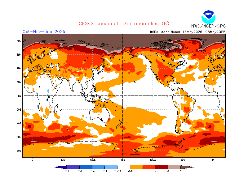
Nevertheless, recent research in my lab group at Irvine proposes the role of positive AMO regimes (warmer than normal north Atlantic SSTs) may be a antecedent indicator of NAO blocking patterns (Peings and Magnusdottir, 2014). This may suggest that we are currently in an extended period of higher frequency cold weather events across Europe and the northeastern United States. For the time being, it is expected that strong warm air advection events and SWFE waves will be likely this winter across the central and eastern CONUS. In addition, the active subtropical jet and warm waters off the eastern seaboard will promote greater frequency of cyclogenesis. Across the west, atmospheric rivers, aka "the pineapple express," will likely bring the threat of heavy rain, particularly for southern California. However, surface temperatures remain in question for how much snow pack can adequately build up in the mountains to help alleviate drought conditions.
Lower Susquehanna Valley Doppler...

(Courtesy of WGAL)
Follow my forecasts on Twitter and Facebook!
My Personal Research and Blog Website: http://sites.uci.edu/zlabe/
3 September 2015
http://sites.uci.edu/zlabe/blog/
Welcome to sunny, southern California. Today's weather forecast: morning clouds, afternoon sun, and a high near 77°F. Pretty monotonous. Occasionally, the temperature will rise a bit higher or the low clouds from the marine may translate to fog, but that is about it. However, changes will be brewing across the area as we dive deeper into the fall season.
Local and national media outlets are filled with our Godzilla El Nino and other buzzwords to describe the continuously warming equatorial Pacific Ocean.
Sea surface temperature (SST) anomalies are forecast to reach near record high levels during the month of September and possibly surpass other strong El Ninos (e.g., 1982-1983 and 1997-1998). NMME/CFS and other long range forecast ensembles are maintaining a peak for this strong El Nino sometime during the early winter period. We later see a quick cooling of SSTs and a more likely than not reversal pattern into a La Nina state by mid to late 2016. These swings are very common after preceding strong +ENSO events.
A fair amount has already been said by the meteorological community concerning the strength of this ENSO event. I think, however, it is worthwhile to again note the extent of the warmer than normal SSTs across both the Pacific and Atlantic. These factors will play a key role in the upcoming winter.
We already know the stereotypical effects of El Nino events on the United States... just look up any map of the 1997-1998 event and there you go. But more wisely, we know that each ENSO event causes vastly different synoptic weather patterns.
It is likely we see the predominant forcing from the equatorial Pacific over the next few months with an amplified Rossby wave pattern dipping south into the midlatitudes. This will allow for an active subtropical jet increasing the probably for storm systems to move into southern California and across the southeastern CONUS before moving northeast.
While subsequent warmer than normal SSTs in the Gulf of Alaska can increase the probability of a -EPO and hence ridge/trough structure over the CONUS, we have been seeing a cooling trend in their anomalies over the last few weeks on the order of 1-2C;. The pattern is becoming less and less favorable for those hoping for a blocking regime across the north Atlantic.
Nevertheless, recent research in my lab group at Irvine proposes the role of positive AMO regimes (warmer than normal north Atlantic SSTs) may be a antecedent indicator of NAO blocking patterns (Peings and Magnusdottir, 2014). This may suggest that we are currently in an extended period of higher frequency cold weather events across Europe and the northeastern United States. For the time being, it is expected that strong warm air advection events and SWFE waves will be likely this winter across the central and eastern CONUS. In addition, the active subtropical jet and warm waters off the eastern seaboard will promote greater frequency of cyclogenesis. Across the west, atmospheric rivers, aka "the pineapple express," will likely bring the threat of heavy rain, particularly for southern California. However, surface temperatures remain in question for how much snow pack can adequately build up in the mountains to help alleviate drought conditions.
Lower Susquehanna Valley Doppler...
(Courtesy of WGAL)
Follow my forecasts on Twitter and Facebook!
My Personal Research and Blog Website: http://sites.uci.edu/zlabe/
No comments:
Post a Comment