It's been a record early start to typhoon season in the Western Pacific, where Category 2
Typhoon Maysak,
with top sustained winds of 100 mph as of 8 pm EDT Sunday, is gathering
strength in the waters a few hundred miles east of Yap State in the
Caroline Islands. Maysak is the fourth named storm so far in 2015 in the
Western Pacific, and the Joint Typhoon Warning Center (JTWC) database
shows only one other year since 1945 with more named storms that formed
during the first three months of the year--1965, when there were five
named storms. Maysak is already the third typhoon of the year, setting a
record for the most typhoons so early in the year. The previous record
for early season typhoons (during January, February, and March) was two,
set in 2005, 1979, and 1955. Major typhoons of Category 3 or stronger
intensity are rare before April, and only fifteen such storms have been
observed between 1945 - 2014. We already have had one major typhoon in
2015--Typhoon Higos, which topped out as a Category 3 storm with 120 mph
winds in February. Maysak has moderate wind shear of 10 - 20 knots and a
large area of ocean with sea surface temperatures of 29°C (84°F) before
it, and appears destined to become a major Category 3 or stronger
typhoon by Tuesday. If this indeed happens, it will mark the first time
two major typhoons have been observed in the Western Pacific during the
first three months of the year. Maysak has a ways to go to become the
strongest early season typhoon, though--there have been two Category 5
super typhoons in the Western Pacific prior to the month of April.
Super Typhoon Ophelia of January 1958 had 160 mph winds, and
Super Typhoon Mitag of March 2002 also had 160 mph winds.
 Figure 1.
 Latest satellite image of Typhoon Maysak.
The
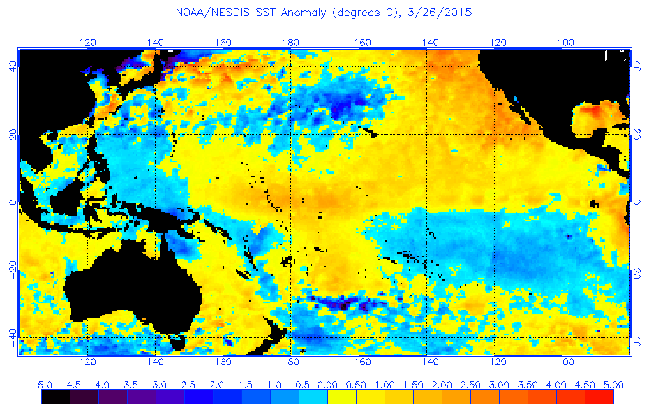
unusually early start to typhoon season is due, in part, to
exceptionally warm waters in the typhoon breeding grounds just west of
the International Date Line between 5 - 10° latitude, due to the weak El
Niño event that is occurring.
Water temperatures there are about 1 - 2°C (1.8 - 3.6°F) warmer than average. Also aiding typhoon formation this month was the
strongest MJO event since record keeping began in 1974,
which moved through the Western Pacific in mid-March. This MJO event
generated an unusually strong band of west-to-east blowing surface winds
near the Equator (a "westerly wind burst") that helped spin up Maysak
and the storm that preceded it,
Tropical Storm Bavi. This
"westerly wind burst"
will be strengthened by the counter-clockwise flow of air around
Maysak, increasing the chances of El Niño lasting into the summer and
potentially strengthening this fall, boosting the odds of a quiet
Atlantic hurricane season.
Maysak a danger to YapMaysak has already dealt a heavy blow to the islands in the Chuuk State in the Federated States of Micronesia, which have a
population of about 50,000.
Maysak passed through the islands as a Category 1 storm over the
weekend. According to TWC's Stu Ostro, Weno Island recorded a wind gust
of 71 mph (62 knots) and 5.60" of rain in three hours.
All communications were down on in Chuuk State as of Sunday night U.S. time,
so it is uncertain how much damage was done. Models predict the center
of Maysak will come close to Yap in the Caroline Islands (population
11,000) as a major typhoon midday on Tuesday (U.S. time.)
There will be a new post by Tuesday morning at the latest.
Jeff Masters
No comments:
Post a Comment