Winter storm and blizzard warnings remain in effect as Winter Storm Argos is poised to intensify in the Plains, eventually spreading snow and wind into the Great Lakes and interior Northeast through this weekend.
(MORE: How Winter Storms Are Named)
Blizzard warnings have been posted for parts of eastern South Dakota, southeast North Dakota and western Minnesota. Winter storm warnings stretch from the Rockies to northern Minnesota.
Current Winter Weather Alerts
(LATEST NEWS: Winter Storm Argos Impacts)
Current Conditions and Radar
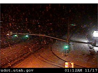
The first snow of the season fell in the Salt Lake City metro area early Thursday, with some enhancement by wind flow over the Great Salt Lake, slickening roads for the Thursday morning commute in some areas. At Salt Lake City International Airport, 0.3 inches of snow was measured.
Snow occasionally accumulating on roads under lake showers. Current image near Stansbury Park. #utwx
Denver saw its first snow of the season, beginning just before noon on Thursday. As of 5 p.m. local time, 0.7 inches had been measured at Denver International Airport.
(MORE: November Reality Check on the Horizon: Colder Temperatures Coming)
Argos will now track from the central Plains to northern Great Lakes through Friday while intensifying. Locations northwest of where that low-pressure system tracks will see accumulating snow.
High winds may lead to white-outs and blizzard conditions in the northern Plains, leading to major impacts along Interstate 80 through western and central Nebraska and Interstate 90 through southeastern South Dakota.
In addition, Interstate 29 from Sioux Falls, South Dakota, to Fargo, North Dakota, and Interstates 94 and 35 in Minnesota will also experience very rough conditions.
(MORE: Snow Cover Is Virtually Absent From the Lower 48 States, a Mid-November Record Low)
This weekend, a secondary area of low pressure may form over the interior Northeast or eastern Canada, producing a round of snow in the interior Northeast and Great Lakes snowbelts.
Here's the general timing for the snowfall as Argos moves east, followed by a look at possible accumulations.
(MORE: Weather-Related Car Accidents Far More Deadly Than Tornadoes, Hurricanes, Floods)
Thursday Night-Friday Forecast
Thursday night into Friday, snow will blanket the eastern Dakotas, central Nebraska and northern Minnesota. As the surface low intensifies, strong north to northwest winds could produce blizzard conditions in open country. Travel could become increasingly treacherous and some road closures are possible.(MORE: Yes, There Is a 'Blizzard Alley,' and It's in the Plains)
Friday's Forecast
(MORE: When the First Snow of the Season Typically Falls)
This Weekend
Saturday's Forecast
A lake-effect snow watch is already in effect for southwestern New York state from Saturday evening through Monday morning.
(MORE: 7-day National Forecast Maps | The Science Behind Lake-Effect Snow)
Moisture wrapping around that secondary, sprawling Québec low will also wring out snow not just over the higher elevations of the Northeast, but also in some lower elevations of the interior from West Virginia to the Mohawk Valley and northern New England. This snow is expected to continue through Monday in some areas.
Sunday's Forecast
How Much Snow Will Fall?
Rockies
- The heaviest accumulations are expected in the higher elevations of far southern Montana and Wyoming (Bighorns, Absaroka, Wind River), and Rockies of Colorado.
- Lighter, but still significant accumulations are expected in the Wasatch, as well as adjacent lower elevations of southern Montana, Utah, Wyoming and Colorado.
Northern Plains
- The heaviest snow is expected over a swath of northern and western Minnesota and eastern South Dakota. Over a foot of snow may pile up in a few parts of northern Minnesota.
- More moderate snow totals are expected to the west over the central and western Dakotas into western and central Nebraska.
- As mentioned earlier, high winds coupled with falling snow may lead to blizzard conditions, at times, particularly over open country. Expect road closures, including sections of major interstates.
Snowfall Forecast
Northeast/Great Lakes
- The potential heaviest snow accumulations this weekend through Monday are targeting higher elevations of northern Vermont, northern New Hampshire, New York state, northwest Pennsylvania, and West Virginia, as well as the eastern Great Lakes snowbelts.
- Some locally heavy accumulations can't be ruled out in the Lake Superior and Lake Michigan northern snowbelts, as well.
- Winds near the Lake Superior shore Saturday could produce whiteout conditions, at times.
- Some accumulations are also possible in some larger cities outside of the areas of heaviest lake-effect, lake-enhanced snow from northeast Ohio to the upper Hudson and Mohawk Valleys of New York.
- No accumulations are expected along the I-95 corridor from Maine to Virginia.
Snowfall Outlook
An Abrupt Reality Check
This will certainly be a big change after October and early November's record warmth across the Rockies, Plains and upper Midwest.For many cities east of the Rockies, this would be the season's first accumulating snow. Here's a list of the average first date of accumulating snow in those locations:
- Cheyenne, Wyoming: October 2
- Lander, Wyoming: September 30
- Rapid City, South Dakota: October 16
- Bismarck, North Dakota: October 26
- Fargo, North Dakota: November 2
- International Falls, Minnesota: October 18
- Marquette, Michigan: October 13
Snowfall Totals From Argos, So Far
Here are the top snow totals by state from Winter Storm Argos, as of Thursday evening.Wyoming: 17 inches near Pahaska
Montana: 16 inches near Red Lodge
Colorado: 12.5 inches near Skyway
Utah: 9 inches near Grand County Airport
Idaho: 7.5 inches near Island Park
Nebraska: 5.0 inches near Harrison
South Dakota: 4.5 inches near Lead
Be sure to check back with weather.com for updates on Winter Storm Argos throughout the weekend.


No comments:
Post a Comment