Published: November 27,2016
Winter Storm Blanche is currently blanketing the mountain West, but will also hammer the northern Plains with snow and wind to start the new week ahead. Blanche will eventually bring wintry weather to the interior Northeast, starting Tuesday.
(MORE: How Winter Storms Are Named)
This winter storm is being caused by a potent southward plunge of the jet stream that is pivoting through the West. The energy associated with that jet-stream dip is spawning an area of surface low pressure in the Plains, where we will see several days of snow and gusty winds. Moisture will also spread well east of that low, producing wintry weather in the interior Northeast.

Current Radar
Central and western North Dakota are under a winter storm warning, while adjacent eastern Montana, northeastern Wyoming and western South Dakota are under a winter storm watch.
(MORE: Winter Storm Central)

Winter Weather Alerts
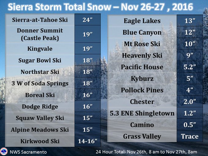
Here are some preliminary snow totals from the storm that went through yesterday & overnight. #snow #cawx #Norcal
More Western Powder Ahead
Here is a general timeline of impacts expected in the West from Blanche through early week.- Through Sunday Night: Snow blankets the Rockies and Four Corners/Mogollon Rim. A separate system brings more snow to the Cascades.
- Monday: A reinforcing shot of cold air and associated weaker storm system will allow more snow to develop by late Monday across much of the Rockies.
(FORECAST: Snoqualmie Pass, Washington | Truckee, California)

Snowfall Forecast
(MORE: 10 Facts About Snow That Might Surprise You)
Northern Plains Snowstorm Ahead
Blanche's surface low-pressure system will pivot northeastward through the Plains Sunday night. Thereafter, it will only move very slowly east into midweek.Initially, cold air will be a bit lacking, so precipitation Sunday night and early Monday will start as rain or a wintry mix in the northern Plains before changing over to wet snow, possibly becoming heavy in some parts of the Dakotas.

Monday's Forecast
(MAPS: Weekly Planner)
For now, the heaviest potential snow accumulations appear to be targeting parts of the Dakotas, where over six inches of snow are possible through the middle of the week ahead. Light to moderate accumulations are expected elsewhere in the northern Plains and upper Midwest.
(FORECAST: Bismarck, North Dakota | Pierre, South Dakota | Minneapolis, Minnesota)

Snowfall Forecast Through Wednesday AM
(MORE: Yes, There is a Blizzard Alley)
Wintry Weather in the Interior Northeast
As mentioned before, moisture associated with Blanche will interact with sufficient cold air in the interior Northeast to produce wintry weather starting Tuesday.
Tuesday's Forecast
The most significant snowfall from Blanche in the Northeast will fall in northern Maine. More than six inches, locally up to a foot, may pile up Tuesday-Thursday.


No comments:
Post a Comment