April 28,2014; 9:00PM,EDT
The worst severe weather outbreak so far this year will continue into Monday night and Tuesday.
"The worst activity will continue into southern Mississippi and central portions of Alabama," AccuWeather.com Meteorologist Randy Adkins Jr. said. "As we head into the night, this squall-line will bring likely bring damaging winds and heavy rain as opposed to tornadoes, however the risk for tornadoes will remain over the course of the next several hours."
The National Weather Service Storm Prediction Center has issued a particularly dangerous situation tornado watch until 9 p.m. CDT Monday for areas of Louisiana, Mississippi, Alabama, and Tennessee. Cities included in this high-risk zone include Jackson, Greenwood, Tupelo, Miss., Huntsville, Ala., and Jackson, Tenn.
The Associated Press reported up to seven people have died due to Monday's severe weather.
RELATED:
Greatest Tornado Danger Focusing on Arkansas, Missouri
AccuWeather Severe Weather Center
Protect Yourself When a Tornado Strikes

UPDATES: (All times in Central time)
10:53 p.m. CDT Monday: The Kimberly Fire Department in Kimberly, Ala., located north of Birmingham, has been destroyed according to 911 call center.10:47 p.m. CDT Monday: A confirmed tornado is tracking towards Birmingham, Ala.

10:41 p.m. CDT Monday: Law enforcement reports multiple gas leaks and property damage south of Tuscaloosa, Ala.
10:25 p.m. CDT Monday: A tornado emergency is now in effect for northwestern Jefferson County, located north of Birmingham, Ala.
10:16 p.m. CDT Monday: A tornado emergency is in effect for southern Tuscaloosa country. This includes the towns of Cottondale and Coaling.
10:12 p.m. CDT Monday: A tornado is on the ground just south of Tuscaloosa, Ala., according to fire department scanner traffic.
9:55 p.m. CDT Monday: The University of Alabama is in the path of a thunderstorm showing strong rotation, possible tornado.
9:24 p.m. CDT Monday: All homes are gone on Price Lane and Howell Hill Road, located near Crystal Springs, Tenn., reports National Weather Service spotter.
8:42 p.m. CDT Monday: Every county in the state of Alabama is under a declared State of Emergency by Robert Bentley, according to Associated Press.
8:34 p.m. CDT Monday: The Associated Press is reporting at least seven have been killed due to severe weather across Alabama and Mississippi.
7:54 p.m. CDT Monday:
7:09 p.m. CDT Monday: NWS and Brandon, MS police department is reporting trees on homes and damage across the city.
6:53 p.m. Monday CDT:
6:45 p.m. Monday CDT: NWS is reporting heavy damage in the suburb of Richland near Jackson, Miss.
6:40 p.m. Monday CDT: A large tornado confirmed by NWS is moving through the suburb of Pearl near Jackson, Miss.
6:12 p.m. CDT Monday: An 18-wheeler overturned on Highway 45 three miles north of Crawford, Miss. emergency management reports.
5:48 p.m. CDT Monday: Watch the latest edition of AccuWeather LIVE below, discussing the most recent details about Monday's outbreak of life-threatening tornadoes across Mississippi, and the storms moving into Alabama.
5:47 p.m. CDT Monday: Supercell with likely tornado now headed towards Columbus, MS.
5:36 p.m. CDT Monday:
5:32 p.m. CDT Monday: A home was struck by lightning in Franklin, Tenn., the emergency manager reports.
5:30 p.m. CDT Monday: Emergency management reports baseball-sized hail in Elkmont, Limestone County, Ala.
5:24 p.m. CDT Monday: Emergency manager confirmed a tornado about four miles southeast of Vicksburg, Miss.
5:15 p.m. CDT Monday: Law enforcement reporting heavy damage just south of Louisville, Miss.
5:07 p.m. CDT Monday:
5:04 p.m. CDT Monday: Significant damage in Louisville, Miss., reports National Weather Service spotter.
4:31 p.m. CDT Monday:
4:12 p.m. CDT Monday: Significant damage in North Tupelo.
3:51 p.m. CDT Monday:
3:36 p.m. CDT Monday:
3:28 p.m. CDT Monday: Supercell with likely tornado less than 50 miles to the southwest of Starkville, Miss.
3:01 p.m. CDT Monday: Watch AccuWeather LIVE below as we go live to cover the life-threatening tornado situation unfolding across Mississippi.
2:53 p.m. CDT Monday: Tornado at the intersection of the Highway 45 and Highway 78 in Tupelo reports National Weather Service spotter.
2:42 p.m. CDT Monday: Multiple-vortex tornado confirmed near Tulepo, Miss.
2:12 p.m. CDT Monday:
1:59 p.m. CDT Monday: Golf ball-sized hail five miles north of Montgomery City, Mo. reports a National Weather Service spotter.
1:39 p.m. CDT Monday: The National Weather Service has issued a tornado watch until 9 p.m. CDT for parts of Louisiana, Alabama, Mississippi, and Tennessee. This is a particularly dangerous situation.
1:25 p.m. CDT Monday:
12:49 p.m. CDT Monday: Quarter-sized hail reported by National Weather Service spotter in Holts Summit, Callaway County, Mo.
12:17 p.m. CDT Monday:
11:49 a.m. CDT Monday: Law enforcement reports a water rescue at the intersection of Highway 166 North and Hampshire Pike, in Maury Co., Tenn.
11:15 a.m. CDT Monday: Flash flooding in Hampshire, Tenn., 10 miles west of Columbia, the emergency manager reports. Water around houses and Highway 412 is washed out in the area.
11:10 a.m. CDT Monday:
10:46: a.m. CDT Monday: Watch the latest edition of AccuWeather LIVE for updates on the severe weather that will continue throughout the day:
10:36 a.m. CDT Monday: Flash flooding reported in Hohenwald, Lewis County, Tenn. Water rescue of a driver on Wildcat Branch Road is underway reports the local fire department.
10:11 a.m. CDT Monday:
9:40 a.m. CDT Monday: Several highways underwater, including Highway 119, 90, 49, 139 and 62, due to flash flooding in Clay County, Ark., according to law enforcement.
8:48 a.m. CDT Monday: Accident on the westbound shoulder of I-40 in Faulkner County, Ark., is causing eastbound delays. Motorists looking at the damage from the Mayflower tornado are also causing delays, according to the Arkansas State Highway and Transportation Department's Twitter account.
7:58 a.m. CDT Monday: Law enforcement in Tipton County, Tennessee, report that several roads are under water and impassable as a result of flash flooding.
7:40 a.m. CDT Monday: FAA lists gate hold and taxi delays at Chicago O'Hare airport as a result of the weather.
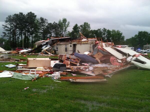
7:20 a.m. CDT Monday: Significant storm damage in Mayflower, Ark.:
 (Photo/James Bryant, @nlrweatherman)
6:55 a.m. CDT Monday: Watch the latest edition of AccuWeather LIVE for updates on the severe weather that will persist through the day:
6:32 a.m. CDT Monday: "A slow-moving cold front will be the focus for the strongest thunderstorms this morning," said AccuWeather.com Meteorologist Mike Leseney. "Severe weather remains a concern across eastern Arkansas, northern Louisiana and from western Tennessee into northern Alabama this morning."
6:17 a.m. CDT Monday:
5:50 a.m. CDT Monday: More than 18,000 are still without power in Arkansas.
5:34 a.m. CDT Monday: Law enforcement in Campbell, Mo., report flash flooding in Dunklin county. The north end of the county reportedly has roads under water, residents required rescue from their homes.
5:13 a.m. CDT Monday: Flood waters are closing roads in portions of Arkansas:
4:54 a.m. CDT Monday: More than 1,200 Empire District Electric Co. customers were without power at this time near Quapaw, Okla., where a tornado struck Sunday, the utility reported.
4:36 a.m. CDT Monday: More than 21,000 Arkansas electric customers were without service at this time, utilities reported.
4:02 a.m. CDT Monday: Lightning ignited a gas well on fire between Mount Enterprise and Garrison, Texas, emergency management reported.
3:55 a.m. CDT Monday: More than 1,600 customers in Bowie County, Texas, were without power Monday morning, Southwestern Electric Power Co. reported.
3:29 a.m. CDT Monday: A home was damaged by a tornado five miles east-northeast of Hosston, Bossier Parish, La., with one person injured, law enforcement said.
3:17 a.m. CDT Monday: Ten people are confirmed dead in Faulkner County, Ark., after Sunday's storm, the Arkansas Department of Emergency Management said.
2:56 a.m. CDT Monday: President Barack Obama, during a news conference in the Philippines, spoke about the central U.S. tornadoes. "Your country will be there to help you recover and rebuild, as long as it takes," The Associated Press quoted the president as saying.
2:48 a.m. CDT Monday: Tennis-ball-sized hail fell at 1:55 a.m. CDT Monday at Hughes Springs, Texas, an NWS spotter reported.
2:36 a.m. CDT Monday: Numerous roads under water at New Madrid, Mo., law enforcement reported.
2:24 a.m. CDT Monday: Non-severe thunderstorms could hamper search-and-rescue efforts in Mayflower, Ark., in about an hour and in Vilonia, Ark., in about two hours, AccuWeather.com Meteorologist Brian Lada said.

2:19 a.m. CDT Monday: Thirteen people now confirmed dead after tornadoes hit Faulkner, Pulaski and White counties in Arkansas, the Arkansas Department of Emergency Management reported.
2:03 a.m. CDT Monday: 3.98 inches of rain fell at Doniphin, Mo., an NWS spotter reported.
1:40 a.m. CDT Monday: More than 19,000 Arkansas electric customers were without power early Monday, utilities reported.
1:09 a.m. CDT Monday: A recreational vehicle park was severely damaged around 10:25 p.m. CDT Sunday, one mile north of the Cape Girardeau, Mo., Regional Airport, emergency management reported. At least seven RVs were damaged with one rolling 25 yards. A pole barn next to the park was destroyed.
12:49 a.m. CDT Monday: Severe property damage reported on Sunday in Baxter Springs, Kan. Gov. Sam Brownback declared a state of emergency.
12:14 a.m. CDT Monday: Numerous trees were downed, including two that fell onto two houses, in Greenwood, Ark., law enforcement reported.
12:02 a.m. CDT Monday: Gov. Mike Beebe's office and the Arkansas Department of Emergency Management said 11 people died there in the tornadoes on Sunday.
11:56 p.m. CDT Sunday: Car under water at a convenience store in Pfeiffer, Mo., from flash flooding, law enforcement reported.
11:47 p.m. CDT Sunday: Storm damage photo from Mayflower, Ark.

Travel trailers and motor homes are piled on top of each other at Mayflower RV in Mayflower, Ark., Sunday, April 27, 2014. A powerful storm system rumbled through the central and southern United States on Sunday, spawning tornadoes. (AP Photo/Danny Johnston)
11:30 p.m. CDT Sunday: 2.8 inches of rain fell seven miles northwest of Poplar Bluff, Mo., with flooding in Butler County, reports trained spotter.
11:09 p.m. CDT Sunday: Arkansas death toll now 8 from tornadoes.
10:53 p.m. CDT Sunday: Death toll rises in Arkansas, according to Gov. Mike Beebe's office.
10:49 p.m. CDT Sunday: Flash flooding in Poplar Bluff, Mo., with water rescues being performed, emergency management reports.
10:36 p.m. CDT Sunday: Damage earlier Sunday from storm in Mayflower, Ark.:
10:34 p.m. CDT Sunday: About 1,500 OG+E customers were without electricity in Oklahoma, the utility reported.
10:25 p.m. CDT Sunday: Damage reports coming out of Vilonia, Ark., include numerous houses damaged or destroyed and a fast-food restaurant damaged, according to trained spotters. The Arkansas Game and Fish headquarters, east of Mayflower, Ark., also was heavily damaged.
10:15 p.m. CDT Sunday: Numerous gas leaks reported in Vilonia, Ark., where search-and-rescue efforts are under way, according to fire department scanner traffic.
10:13 p.m. CDT Sunday: Arkansas state government responding to severe storms:
10:02 p.m. CDT Sunday: Traffic causing problems for responders in Quapaw, Okla.:
9:56 p.m. CDT Sunday: Major gas leak reported on North Street in storm-damaged Vilonia, Ark., according to fire department scanner traffic.
9:48 p.m. CDT Sunday: About 14,000 Entergy Arkansas customers were without power, the utility reported.
9:32 p.m. CDT Sunday: Tornado emergency at Swifton, Ark., the NWS said.
9:29 p.m. CDT Sunday: Mayflower, Ark., tornado:
9:22 p.m. CDT Sunday:

9:15 p.m. CDT Sunday: Tornado spotted at Jacksonport, Arkansas, law enforcement reports.
9:00 p.m. CDT Sunday:
8:54 p.m. CDT Sunday: The National Weather Service is reporting a tornado emergency for Thida and Oil Trough, Ark.
8:47 p.m. CDT Sunday: Law enforcement reporting a tornado in Denmark, Ark.
8:41 p.m. CDT Sunday: Around 17,000 power outages with 11,000 in Pulaski County, Ark reports Entergy Arkansas
8:33 p.m. CDT Sunday: According to KATV in Little Rock, one person has been confirmed dead along Highway 365 in Mayflower.
8:11 p.m. CDT Sunday:
8:02 p.m. CDT Sunday: El Paso and Floyd, Ark., under tornado emergency.
7:58 p.m. CDT Sunday The tornado-producing cell is now northeast of Vilonia, approximately 25 miles to the southwest of Searcy, Ark.
7:47 p.m. CDT Sunday The National Weather Service in Little Rock is reporting houses badly damaged south of Mayflower, Ark. and Saltillo, Faulkner County, Arkansas.
7:36 p.m. CDT Sunday: A tornado, estimated at around half a mile wide, has crossed Interstate 40 around mile marker 140, one mile southeast of Mayflower, Ark. reports National Weather Service spotter.
7:19 p.m. CDT Sunday: The National Weather Service in Little Rock, Ark., has issued a tornado emergency in effect for Maumelle, Ark. A tornado was reported along Lake Maumelle.
6:51 p.m. CDT Sunday:
6:36 p.m. CDT Sunday: A very large storm is currently moving north, bringing hail to the southwest suburbs of the Kansas City metropolitan area, and has the potential to develop a tornado as it tracks north, AccuWeather.com Meteorologist Brian Edwards said.
6:18 p.m. CDT Sunday Emergency management reports a funnel cloud, three miles southwest of Foster, Bates County, Mo.
6:05 p.m. CDT Sunday: Joplin, Mo., Airport reported a tornado on the ground around 5:52 p.m. CDT.
5:51 p.m. CDT Sunday: Watch the latest edition of AccuWeather LIVE for updates on the severe weather outbreak:
5:42 p.m. CDT Sunday: Dust storm and visibility under one mile reported near Great Bend, Barton County, Kan., reports National Weather Service spotter.
5:32 p.m. CDT Sunday
4:58 p.m. CDT Sunday: A storm chaser sighted a brief tornado touch down south of Polk, Neb., according to the National Weather Service. This tornadic thunderstorm will continue to track just east of Polk and Clarks, Neb., within the next 30 minutes.
4:47 p.m. CDT Sunday: Confirmed tornado located near Mount Vernon, Iowa, tracking toward Morley and Martelle, Iowa.
4:37 p.m. CDT Sunday: Thunderstorms with a history of producing hail and damaging winds approaching Davenport, Iowa.
4:24 p.m. CDT Sunday: A thunderstorm capable of producing a tornado located near Messer, Okla., tracking south of Rattan, Okla.
4:17 p.m. CDT Sunday:
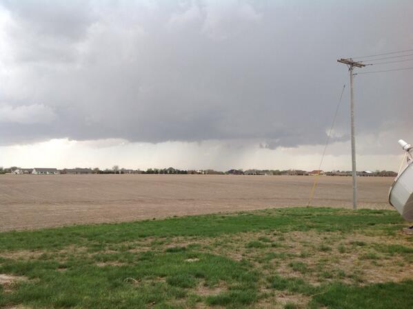
 Storm clouds moving over Alda, Neb. (Photo/@EXTREMECHASER)
3:52 p.m. CDT Sunday: The Storm Prediction Center has labeled the tornado threat across Arkansas, including Little Rock, a "particularly dangerous situation;" violent tornadoes a serious concern.
3:44 p.m. CDT Sunday:
3:21 p.m. CDT Sunday: A funnel cloud has been reported one mile north of Floris, Iowa by a National Weather Service spotter.
2:42 p.m. CDT Sunday: A confirmed tornado was located near Upland, Nebraska, and tracking toward the community of Minden, Nebraska.
2:28 p.m. CDT Sunday: Severe thunderstorms, with the threat of tornadoes, are tracking in an unusual southeast-to-northwest fashion across Nebraska.

2:25 p.m. CDT Sunday: A thunderstorm capable of producing a tornado and quarter-sized hail was tracking toward Hildreth, which was located in south-central Nebraska.
1:50 p.m. CDT Sunday: Tornado danger is increasing in and around western and central Arkansas, prompting the issuance of a tornado watch. This watch includes Little Rock and is in effect until 9 p.m. CDT.
1:20 p.m. CDT Sunday: All severe weather watches and warnings are listed on the AccuWeather.com Severe Weather Center page.

1:10 p.m. CDT Sunday: A thunderstorm that caused tree damage in Warrensburg, Missouri, it tracking toward Sweet Springs, Missouri.
12:55 p.m. CDT Sunday: Looking to the southeast, a funnel cloud was sighted in Richmond, Missouri. The person who reported the sighting to the National Weather Service also noted the occurrence of dime-sized hail.
12:53 p.m. CDT Sunday: A thunderstorm capable of producing a tornado was located near Odessa, Missouri, and was tracking toward the communities of Dover and Carrollton. This thunderstorm produced a 60-mph wind gust in Odessa.
12:40 p.m. CDT Sunday: A line of thunderstorms with a history of producing hail and damaging winds continues to track across northwestern Missouri.

12:30 p.m. CDT Sunday: The environment is becoming more conducive for the development of tornadoes in the vicinity of western Arkansas. Thunderstorms capable of spawning tornadoes will begin to increase in coverage across this area during the mid-afternoon hours.
12:25 p.m. CDT Sunday: National Weather Service observer reports penny-sized hail from a thunderstorm eight miles west of Callaway, Neb.
12:04 p.m. CDT Sunday: While a line of severe thunderstorms is pressing into Missouri, AccuWeather.com meteorologists remain concerned for tornadic thunderstorms to erupt across far eastern Oklahoma, northeastern Texas and Arkansas as the afternoon progresses.
11:56 a.m. CDT Sunday: AccuWeather.com meteorologists identified central Nebraska as another area at risk for strong thunderstorms Sunday afternoon.
11:49 a.m. CDT Sunday: Winds gusted to 57 mph when a line of severe thunderstorms tracked across the Kansas City International Airport, Mo.
11:40 a.m. CDT Sunday: Quarter-sized hail slammed Parkville, Mo.
11:25 a.m. CDT Sunday: A thunderstorm dropped golf ball-sized hail on Overland Park, Kan., according to a National Weather Service spotter.
@AviWxChasers
Follow
Tornado Warned Cell earlier in SouthWest Missouri. Granby, Mo. Sirens were blaring! http://fb.me/1fSAtRotq
Governor Mike Beebe
@GovBeebeMedia
Follow
@AR_Emergencies has confirmed four tornado-related deaths so far. Three in Pulaski County, one in White County. #arwx
Governor Mike Beebe
@GovBeebeMedia
Follow
Four confirmed fatalities in Faulkner County, 8 total for the night so far. Track information from ADEM here: http://1.usa.gov/1h5mbL3 #arwx
NWS Jackson MS ✔
@NWSJacksonMS
Follow
2:10 PM: Spotters report a tornado southwest of Yazoo City moving NE. Yazoo City residents seek shelter immediately! #mswx
Major damage in Louisville


No comments:
Post a Comment