June 30,2014; 9:24PM,EDT
Severe weather will lash through areas from the Midwest to the Great Lakes into Tuesday, hitting some of the major cities in the United States, including Chicago, St. Louis and Detroit.
The danger has transitioned into more of a widespread damaging wind threat for areas farther east and south into Illinois, Missouri, northern Indiana and southwestern Michigan.
Strong storms can cause property damage, put lives in danger and impact travel across central U.S.
RELATED:
Storms, Tornadoes to Slam Chicago, St. Louis Monday
Interactive Chicago Radar
Map: Current Severe Weather Watches and Warnings

UPDATES: (All times are listed in CDT)
10:45 p.m. CDT Monday:
Left side normal, right side lighting. Wow. #chicago #thunderstorms
11:01 p.m. CDT Monday: A wind gust of 86 mph was reported in Lowell, Indiana by mesonet.
10:15 p.m. CDT Monday: Wind gusts up to 82 mph in Bolingbrook, Illinois, reports NWS spotter.
9:39 p.m. CDT Monday: Another line of storms is about to blast through the Chicago area.

9:28 p.m. CDT Monday: Wind gust of 77 mph was measured in Guymon, Oklahoma, according to NWS observation.
8:56 p.m. CDT Monday: Funnel cloud spotted near Green Castle,Missouri, reports NWS trained spotter.
8:36 p.m. CDT Monday: Flooding and cars stalled in streets reported in Freeport, Illinois, reports emergency manager.
8:20 p.m.CDT Monday: Tornado reported on the ground along highway H near I-35 near Gilman City, MO, reports law enforcement.
8:10 p.m. CDT Monday:
Gotta love summers in Chicago
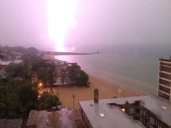
7:55 p.m. CDT Monday
Lightning strike far to the north of #rogerspark. #derecho
7:50 p.m. CDT Monday:
7:33 p.m. CDT Monday:
7:17 p.m. CDT Monday: Chicago, Illinois:
6:45 p.m. CDT Monday: Approximatley 70,000 Alliant Energy Iowa customers are currently without power, reports the utility.
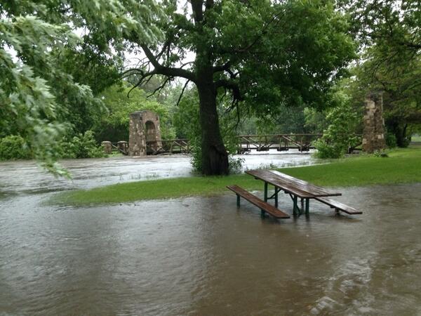
6:13 p.m. CDT Monday: Flooding in Madison, Wisconsin.
 (Photo/Twitter user Alyssa Reif @AMarieR5)
6:09 p.m. CDT Monday:
5:30 p.m. CDT Monday: Derecho moving eastward towards Chicago, expected to arrive in the city within the next 90 minutes. Current radar:

4:51 p.m. CDT Monday: Heavy winds earlier this afternoon in Cedar Rapids.
(Youtube video/Forrest B. Saunders)
4:31 p.m. CDT Monday: Wind damage in Cedar Rapids, Iowa.

 (Photos/Twitter user Brittany Nissen @bittymishel)
4:14 p.m. CDT Monday:
4:07 p.m. CDT Monday: Derecho Alert: Illinois, Wisconsin and Michigan.
3:32 p.m. CDT Monday: From around 3 p.m. CDT Monday, looking west from Salon, Iowa.
 (Photo/Twitter user Scott Sutton @scottnpd)
3:13 p.m. CDT Monday:
3:11 p.m. CDT Monday: NWS spotter reported two inches of rain in 20 minutes near Dunkerton, Iowa.
2:56 p.m. CDT Monday: NWS spotters estimated 80 mph winds or higher near Cedar Rapids. High winds were observed for more than five minutes.
2:37 p.m. CDT Monday: NWS spotters estimated 60 to 70 mph wind gusts near Marengo, IA.
2:35 p.m. CDT Monday:
2:09 p.m. CDT Monday: Semi-truck blown on I-35 one mile southeast of Bevington, Iowa.
Semi blown over on I-35 near Bevington. Follow storm updates: http://dmreg.co/1voVfNg #iawx
1:54 p.m. CDT Monday:
1:30 p.m. CDT Monday:
1:25 p.m. CDT Monday;
12:53 p.m. CDT Monday: "There is a likely tornadic supercell that definitely is causing large hail about 40 miles SW of Des Moines and heading in the general direction of Des Moines," said AccuWeather.com Senior Meteorologist Frank Strait.
12:26 p.m. CDT Monday: In addition to the significant risk of tornadoes, the threat of a derecho is developing for Iowa, according to Mike Smith,senior vice president and chief innovation executive for AccuWeather Enterprise Solutions.
12:02 p.m. CDT Monday: Golf ball-sized hail near Boxholm, Iowa, the emergency manager reports.
12:00 p.m. CDT Monday: Up to 3.25 inches of rain have been recorded by an NWS-trained spotter in Linn County, Iowa, since last night. Current radar:

11:45 a.m. CDT Monday: A tornado watch has been issued from Nebraska to Iowa. Andrew Baglini explains:
11:00 a.m. CDT Monday: Watch our new edition of 'AccuWeather LIVE' for the latest storm updates:
10:45 a.m. CDT Monday: An inch of rain was reported in just 12 minutes in Norfolk, Nebraska.
10:35 a.m. CDT Monday: Grapefruit-sized hail now reported by NWS-trained spotter in Rockwell City, Iowa.
10:20 a.m. CDT Monday:
Hail in Harlan, IA this morning. @RustyLord
9:55 a.m. CDT Monday: Hail measuring 2 inches in diameter, about the size of a hen egg, has been reported by an emergency manager in Harlan, Iowa.
9:45 a.m. CDT Monday: According to the FAA, Chicago's O'Hare International Airport is experiencing gate hold and taxi delays as a result of the stormy weather in the Midwest.

9:25 a.m. CDT Monday:
9:15 a.m. CDT Monday: Law enforcement in Wayne County, Nebraska, reports golf ball-sized hail.
8:55 a.m. CDT Monday: A 911 call center reports flash flooding in Rhea County, Tennessee.
8:30 a.m. CDT Monday: Law enforcement in Pierce County, Nebraska, report a brief funnel cloud in the area.
8:15 a.m. CDT Monday: Benton County, Iowa, has received 2.75 inches of heavy rain so far, according to an NWS spotter.
On Social Media

Bill Verzal
bjverzal
“@breakingweather: Wind gusts up to 82 mph in Bolingbrook, Illinois, reports NWS spotter. ow.ly/yDkq0”

Joanne Guthrie-Gard
jojogard
LIVE: Tornadoes, Storms Develop in Plains, Threaten Chicago Next accuweather.com/en/weather-new…

HailWATCH
hailwatch
WIND GUST 50 MPH, reported @ 06/29/2014 23:45 CDT
IA, IOWA CITY(5 NW) - Zip Code: 52241 Zip P... Read more at bit.ly/1mLT8CH
23h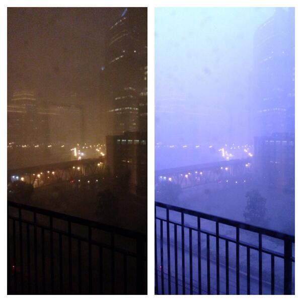









No comments:
Post a Comment