Monday, June 30, 2014

Tropical Storm Elida Forms: Warnings Issued, Heavy Rain Threat for Mexican Coast

Published: Jun 30,2014, 11:27AM,EDT weather.com


Overlay

Tropical Depression One in the Atlantic


Tropical Storm Elida, the fifth named storm of the eastern Pacific hurricane season, has formed about 120 miles south of Manzanillo, Mexico.
Elida is forecast to meander or stall off the Mexican coast for the next few days. Fortunately, strong northwest winds aloft are shearing the storm, not allowing it to strengthen while it lollygags offshore.
While Elida is not expected to strengthen appreciably, unlike Douglas to its west, Elida will have some impacts on the Mexican coast.
Tropical storm-force winds will expand along the Mexican Pacific coast, generally within the tropical storm warning area shown in the map below. Those winds will continue to generate swells and rip currents along the beaches. Heed any warnings from lifeguards to stay out of the water if you're visiting the area.
The other impact with slow-moving tropical cyclones is heavy rain. Some parts of southwest Mexico may pick up over 6 inches of total rainfall over the next several days, leading to local flash flooding and mudslides.
(FORECAST: Acapulco | Puerto Vallarta | Cabo San Lucas)
Background

Projected Path

Projected Path

Projected Path

The latest forecast path and wind speeds from the National Hurricane Center.

Background

Storm Information

Storm Information

Current Information

So, where exactly is the cyclone's center located now? If you're plotting the storm along with us, the information depicted in the map above provides the latitude/longitude coordinates, distance away from the nearest land location, maximum sustained winds and central pressure (measured in millibars).

Background

Watches/Warnings

Watches/Warnings

Tropical Storm/Hurricane Watches/Warnings

A tropical storm or hurricane watch is issued when those conditions are possible within the area. Watches are typically posted 48 hours in advance of the onset of tropical storm-force conditions, since preparing for the storm becomes difficult once tropical storm-force winds begin. A tropical storm or hurricane warning means those conditions are expected in the area. Warnings are typically issued 36 hours in advance of the onset of tropical storm-force winds. When a warning is issued, you should complete all storm preparations and, if directed by local officials, evacuate the area immediately.

Background

Infrared Satellite

Infrared Satellite

Infrared Satellite

This infrared satellite image shows how cold (and therefore how high) the cloud tops are. Brighter orange and red shadings concentrated near the center of circulation signify a healthy tropical cyclone.

Background

Visible Satellite

Visible Satellite

Visible Satellite (only during daylight hours)

This visible satellite image helps meteorologists pinpoint the low-level circulation center during daylight hours. In cases of strong wind shear (stronger winds aloft than near the surface, sometimes from different directions), one can spot an exposed circulation center, with convection blown downstream. This is an indication of a weakening tropical cyclone.

MORE ON WEATHER.COM: Hurricanes From Space

Hurricane Igor is featured in this Sept. 14, 2010, image photographed by an Expedition 24 crew member on the International Space Station. (NASA)

Tropical Depression One Forms Off Florida Coast; Tropical Storm Watch Issued for Parts of Florida

Published: Jun 30,2014, 10:58PM,EDT weather.com
Overlay

Tropical Depression One in the Atlantic

Key Takeaways

  • A tropical depression has formed off the Florida coast, and is expected to strengthen.
  • A tropical storm watch is in effect from Fort Pierce north to just south of Flagler Beach on the east coast of Florida.
  • This system will likely track near parts of the Eastern Seaboard, particularly from Florida to North Carolina, this Fourth of July holiday week.
  • All residents from eastern Florida to the Mid-Atlantic coast and far southeast New England should monitor the progress of this system.
Tropical Depression One has formed about 100 miles east of Cape Canaveral, Florida. It's the 2014 Atlantic hurricane season's first tropical depression.
It is still experiencing some light northerly wind shear, displacing thunderstorms somewhat from the center of circulation. There is also some residual dry air lurking to the north and northeast of the fledgling surface low. Most thundershowers associated with this low had stayed off the coast, but are now pushing into the northwest Bahamas and will scrape the Florida coast generally south of Cape Canaveral over the next several days.
(INTERACTIVE LOOPS: Radar | Satellite)
This low is currently caught in an environment of weak steering winds aloft, so it is likely to loaf and lollygag near or off the east coast of Florida and north of the northwest Bahamas through Tuesday.
However, it is also situated over the Gulf Stream, a ribbon of warmer water off the Southeast U.S. coast. Furthermore, the somewhat hostile conditions (wind shear, dry air) limiting the system's organization the past few days are expected to lessen. The longer the low hovers and percolates convection, the more possible it is for the convection to organize around the center and begin the process of intensifying the tropical cyclone.
The first named storm of the 2014 Atlantic hurricane season is Arthur.
Background

Projected Path

Projected Path
Above: The latest forecast path and wind speeds from the National Hurricane Center.
By Wednesday or Thursday, an approaching cold front and southward dip, or trough, in the jet stream, in concert with strengthening high pressure near Bermuda, are expected to pick this system up and steer it toward the north then northeast.
Eventually by late this week, the system will take a sharper northeast turn out into the open Atlantic, as the jet stream westerlies exert their steering influence.
There are several key lingering uncertainties at this time:
  • Will the low strengthen over the ocean before it's picked up by the trough, or will it actually drift southwestward over the Florida Peninsula before turning toward the north-northeast, lessening the chance of it intensifying?
  • If it stays over water, how close to the coast will the system track and how strong will it become?
  • How far will it track up the East Coast before making the turn farther offshore?
Uncertainty this far out in time is typically high, as depicted in the forecast model tracks image below. However, the general scenario outlined earlier is of higher confidence.
Whether this becomes a heavy rain, strong wind, coastal flooding/beach erosion, high surf and rip current threat at any given location depends on all these uncertainties in both track and intensity. It is still a bit too far out in time to make any definitive calls on potential impacts later this week.
Interests along the coast from eastern Florida to the Mid-Atlantic coast and even far southeast New England should monitor the progress of this system as we head through the Fourth of July holiday week.
(FORECAST: Jacksonville | Charleston | Myrtle Beach | Outer Banks | Va. Beach)
We have additional current status and forecast maps below, including watches, warnings, satellite imagery and model track forecasts.
Background

Storm Information

Storm Information

Current Information

So, where exactly is the cyclone's center located now? If you're plotting the storm along with us, the information depicted in the map above provides the latitude/longitude coordinates, distance away from the nearest land location, maximum sustained winds and central pressure (measured in millibars).

Background

Watches/Warnings

Watches/Warnings

Tropical Storm/Hurricane Watches/Warnings

A tropical storm or hurricane watch is issued when those conditions are possible within the area. Watches are typically posted 48 hours in advance of the onset of tropical storm-force conditions, since preparing for the storm becomes difficult once tropical storm-force winds begin. A tropical storm or hurricane warning means those conditions are expected in the area. Warnings are typically issued 36 hours in advance of the onset of tropical storm-force winds. When a warning is issued, you should complete all storm preparations and, if directed by local officials, evacuate the area immediately.

Background

Model Track Forecasts

Model Track Forecasts

Model forecast tracks

The various tracks shown in the map above illustrate possible tracks of the center of the tropical cyclone from various hurricane forecast models. The degree of spread in the tracks reflects the degree of uncertainty in the track of the tropical cyclone. A tight clustering of tracks can signify a higher-confidence track forecast compared to a large spread in model tracks. None of these tracks are the official forecast track. That is shown, instead, by a forecast path, cone or swath, illustrating an uncertainty in the future track. Also, the impact of any tropical cyclone can stretch well beyond the track of the storm's center.

Background

Infrared Satellite

Infrared Satellite

Infrared Satellite

This infrared satellite image shows how cold (and therefore how high) the cloud tops are. Brighter orange and red shadings concentrated near the center of circulation signify a healthy tropical cyclone.

Background

Visible Satellite

Visible Satellite

Visible Satellite (only during daylight hours)

This visible satellite image helps meteorologists pinpoint the low-level circulation center during daylight hours. In cases of strong wind shear (stronger winds aloft than near the surface, sometimes from different directions), one can spot an exposed circulation center, with convection blown downstream. This is an indication of a weakening tropical cyclone.
Check back with us at weather.com and The Weather Channel for the latest updates on this potential Fourth of July holiday week storm.
(MORE: Expert Analysis | WeatherREADY hurricane safety | Hurricane Central)

MORE ON WEATHER.COM: Hurricanes From Space

One of the Expedition 33 crew members aboard the International Space Station took this photo of Hurricane Sandy at 16:55:32 GMT on Oct. 29, 2012. (NASA)

Free Smartphone Apps can be Lifesavers During Severe Weather

By Erin Cassidy, Accuweather.com Staff Writer
June 30,2014; 7:45AM,EDT


Some severe weather events give ominous and obvious signs, while others can seemingly appear from a clear sky without warning. But as we've witnessed many times, especially in the aftermath of the 2013 tornadoes in Moore and Oklahoma City, Okla., severe storms can be swift and devastating.
Strewn debris from the EF-5 tornado that struck the Joplin, Mo., area, shown June 14, 2011, reminds of the devastation the May 22 storm caused. The U.S. Army Corps of Engineers is managing debris removal as part of the federal tornado recovery effort. (U.S. Army Photo/John Daves)
It's difficult enough to reach shelter when you are at home or at least in familiar surroundings. Imagine encountering a tornado when you are seeing a medical specialist located two hours from your home or driving into a hurricane's path while on a cross-country summer road trip with your family. You may not even know the county you are in, let alone where storm shelters are located.
Fortunately, you already carry a crucial item for severe-weather safety - your smartphone. Utilizing your mobile resources is an important step in ensuring you and your family's safety. Using an app over traditional media sources can save you precious time in the event of an emergency. "The information already lives on your phone; all you need to do is access the app or even check your home screen for alerts." says Brandon Marsh, Product Manager of Mobile Applications at AccuWeather.
The following smartphone apps were created to issue alerts and warnings in real time to maximize your chances of reaching shelter or escaping the storm's path. These apps help you stay informed and stay safe.

AccuWeather

AccuWeather provides a free app that works not only as a general forecasting tool, but also as a severe weather advisory. It pushes alerts to your home screen automatically if an alert is issued in your area. "It functions as not only an encyclopedia of weather data, but it also automatically alerts you to the most impactful weather," explains Marsh, "The AccuWeather app helps people make actionable decisions."
If the National Weather Service issues a warning for your home location, the app can automatically send a push alert to your device that will appear on your lock screen or in Notification Center. If you are away from home, you can easily check the area's forecasts and warnings by adding a new location to your saved list. To add a location via GPS, click the plus sign on the top-right of the screen, then press the GPS navigation arrow to automatically view weather for your exact location.
If you are planning on a road trip this summer, be sure to consult AccuWeather's Road Trip Planner to stay well-informed of weather along your intended route.
Tornado Twins El Reno, Oklahoma in 2013. (Credit: Flickr/Daniel Rodriguez)

American Red Cross

The American Red Cross provides free apps specifically geared towards certain severe weather events such as tornadoes and hurricanes. "Tornado by American Red Cross" and "Hurricane by American Red Cross" were created not only to alert users about incoming severe weather, but also to help them prepare and respond accordingly. Don Lauritzen, Officer of Preparedness and Health and Safety Services Communications for the Red Cross, says, "People can take action before a tornado strikes - even when they aren't paying attention to the weather. A high-pitched siren and 'tornado warning!' message will sound when a NWS tornado warning is issued in their area - even if the app is closed."
Other features of the app include an "I'm Safe" feature that sends messages to friends and family, a map pinpointing available shelters, a toolkit with a flashlight and strobe light and historical information on the past weather events in your region. The American Red Cross also provides apps with safety information regarding wildfires, earthquakes, first aid skills and a shelter finder. Access to the app's features means "peace of mind for frequent travelers or those with family in other parts of the country," adds Lauritzen.
Even during calm weather, use these apps to review important facts and preparedness quizzes to test and sharpen your awareness. Earn all the "badges" to be a veritable expert on severe weather and emergency preparedness. These apps are available for free on both iOS and Android platforms or you can receive download links by calling "**REDCROSS" (**73327677).

Local Weather Apps

Your local news station may also provide an app that provides up-to-date weather warnings customized to your region. Search Google Play or iTunes for more information.
To be not only alerted but also prepared for when severe weather strikes, these apps are essential. Lauritzen says, "The app allows people to access this life-saving information whenever and wherever they need it."
Make sure to download these apps today, and follow their recommendations to ensure your safety in the face of severe weather.

Tropical Storm Douglas Spins Off Mexico's Pacific Coast

June 30,2014


Tropical Storm Douglas, the fourth named storm of the eastern Pacific hurricane season, is holding status quo about 450 miles southwest of Cabo San Lucas, Mexico.
First born as Tropical Depression Four-E Saturday afternoon, Tropical Storm Douglas is expected to track west-northwest, then curl west over the next several days, posing no direct threat to land.
Douglas is already moving over cooler ocean water, and has failed to consolidate convection near its center all along, putting a cap on its strengthening, unlike early-season dynamos Amanda and Cristina.
A slow weakening thanks to an environment less favorable for convection (stable air) later this week will likely take Douglas to remnant low status by the weekend.
Background

Projected Path

Projected Path

Projected Path

The latest forecast path and wind speeds from the National Hurricane Center.

Background

Storm Information

Storm Information

Current Information

So, where exactly is the cyclone's center located now? If you're plotting the storm along with us, the information depicted in the map above provides the latitude/longitude coordinates, distance away from the nearest land location, maximum sustained winds and central pressure (measured in millibars).

Background

Infrared Satellite

Infrared Satellite

Infrared Satellite

This infrared satellite image shows how cold (and therefore how high) the cloud tops are. Brighter orange and red shadings concentrated near the center of circulation signify a healthy tropical cyclone.

MORE: Hurricanes From Space

NASA image acquired Sept. 13, 2010, at 16:40 UTC Hurricane Igor in the Atlantic Ocean. (NASA/GSFC/Jeff Schmaltz/MODIS Land Rapid Response Team)

Derecho Hits Chicago And Milwaukee: 1 Dead, Several More Injured in Iowa

June 30, 2014
A derecho swept from the Midwest to the western Great Lakes Monday, bringing hurricane-force wind gusts, reported tornadoes and heavy rain into Iowa and Nebraska. The storms are blamed for one death just southwest of Cedar Rapids, Iowa, where police say a man was trapped inside a collapsed building.
Several people were injured during a minor league baseball game at Veterans Memorial Stadium in Cedar Rapids when they were trying to put the tarp over the field, according to KCRG.com.
(MORE: What Is a Derecho?)
Below is a state-by-state rundown of the areas already affected by this severe weather outbreak.
(MORE: Track the Severe Threat As It Moves East)

Illinois

Flights were cancelled at Chicago's O'Hare and Midway International airports and Commonwealth Edison reports electric power to thousands was disrupted by a derecho that moved across the area Monday afternoon.
A second line of strong storms prompted the National Weather Service to impose a severe thunderstorm watch until 3 a.m. Tuesday for Illinois, including Cook, Peoria and Kankakee counties.
Hundreds of flights at Midway and O'Hare were canceled or delayed by Monday's storm, as were trains operated by the Metra commuter rail service.
The storm also forced postponement of Monday's Angels-White Sox game in Chicago.

Iowa

Linn County Sheriff Brian Gardner told The Weather Channel the powerful storms hit Interment Technologies in Fairfax, just southwest of Cedar Rapids, around 3 p.m. A male employee was trapped inside and died.
Violent 80 mph winds left more than 95,000 customers without power. CBS 2 in Cedar Rapids says the storms left damage in "just about every neighborhood." Images show large tress down on homes and vehicles, as well as entire structures blown over.

Tiffany O'Donnell/Twitter
Violent winds brought trees down onto this vehicle in Cedar Rapids, Iowa.
Several employees and stadium volunteers were hurt during a minor league baseball game in Cedar Rapids. KCRG. com reports they were trying to roll the tarp over the field when the wind knocked people onto the ground and then pushed the tarp on top of them. At least three reportedly sustained concussions while the assistant general manager dislocated his shoulder.
In the community of North Liberty, which is northwest of Iowa City, at least one person was hospitalized when the person was trapped under a tree. No word yet on the severity of those injuries.
KCRG reports that rescue crews in Cedar Rapids were scouring a storm drain after two teens were swept away by flood waters. One of the teens was able to escape. The other remained missing Monday night. 
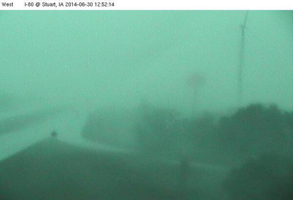
Earlier in the day, a possible tornado was reported near Stuart. Damage to houses and other buildings were also reported in Warren County as storms moved through the area.
Officials say there have been reports of golf ball-size hail and wind gusts of up to 70 mph. There are no reports of injuries.
On Monday, a severe thunderstorm capable of producing a tornado was located four miles southeast of Earlham and nine miles east of Roland. Additional information was not available, and there are no reports of injuries.
Gov. Terry Branstad has issued a disaster proclamation for Adair, Cedar, Guthrie, Jones and Linn counties. Branstad's proclamation Monday means state resources can be used to respond to ongoing flooding and severe weather.
The derecho comes one day after severe weather produced heavy rain and wind gusts of up to 70 mph. A highway in Fairfax partially collapsed and the driver of a truck was injured, though additional information was not available. Part of a highway near Mount Vernon also partially collapsed. There were no reports of injuries.

Nebraska

A severe thunderstorm caused some damage in rural northeast Nebraska Monday morning, but mostly avoided the area around Pilger that was hit hard by storms earlier this month.
The National Weather Service says the storm destroyed some outbuildings and damaged at least one home in Pierce County just northwest of the town of Hadar.
Emergency management officials reported a tornado as the storm moved across Pierce County.
The storm also generated hail up to 1.75 inches in diameter near Pender and Walthill.
But the storm stayed north of the Stanton County town of Pilger that was heavily damaged by a tornado on June 16.

Wisconsin

Heavy rain brought flash flooding into southern Wisconsin Monday. Photos posted on Twitter show main roads in Madison flooded during rush hour.
At least 105,000 customers had lost electricity as of Monday night.
The region dealt with damaging storms Sunday, too. A tornado was reported in Iowa County around 11 p.m., Brian Hahn with the National Weather Service in Sullivan said. In Dane County, an EF1 tornado was confirmed after leaving damage near the town of Oregon Sunday night, according to the NWS.
Hahn said the Weather Service received reports of a "swath of damage" from Highland east toward Dodgeville. Straight-line winds could also have been the cause. No injuries were reported.
The Iowa County Sheriff's Office said it had received reports of wind damage. A message left with the Iowa County emergency manager was not immediately returned.
Information from the Associated Press was used in this report.
MORE: Photos of June 30th Derecho
Storm clouds over Cedar Falls, Iowa on Monday evening. (Epic Cosmos/twitter)

Weather Underground National Forecast for Monday, June 30, 2014

By: nationalsummary , 10:11PM,GMT on June 29,2014

Weather Underground Forecast for Monday, June 30,2014

A cold front will extend from the Great Basin to the upper Midwest on Monday, while an area of low pressure will linger over the southern Mid-Atlantic.

A strong low pressure system will inch across the northern tier of the country on Monday, focusing over the upper Mississippi Valley and the western Great Lakes. A cold frontal boundary associated with this system will extend across the Great Basin, the central Rockies, the central Plains and the upper Midwest. As warm, humid air collides with this frontal boundary, strong to severe thunderstorms will develop across the nation’s midsection. Severe thunderstorms will be possible across northern Texas, southeast Colorado, northern Oklahoma, Kansas, Arkansas, Iowa, Illinois, southern Wisconsin, northwest Indiana and southwest Michigan. These thunderstorms will be capable of producing large hail, dangerous straight line winds and isolated tornadoes. In addition, heavy rain associated with these thunderstorms could lead to flash flooding across the upper Mississippi Valley. Scattered showers and thunderstorms will also be possible over the northern Plains.

Meanwhile, an area of low pressure will inch southward along the coasts of Georgia and Florida on Monday. This system will bring very stormy weather to the southeast, and will have a high, 60% chance to develop into a tropical cyclone. Disorganized showers and thunderstorms will also be possible across the Ohio Valley and parts of the Northeast.

Out west, a ridge of high pressure over the eastern Pacific will keep conditions mostly clear across the West Coast. Temperatures will approach 110 degrees across the Desert Southwest on Monday.

This Date in Weather History for June 30,2014 from weatherforyou.com

Weather History
For Monday,June 30,2014


1886 - The second destructive hurricane in nine days hit the Apalachicola-Tallahassee area. (David Ludlum)
1942 - The temperature at Portland, OR, hit 102 degrees, an all-time record for that location. (The Weather Channel)
1972 - The entire state of Pennsylvania was declared a disaster area as a result of the catastrophic flooding caused by Hurricane Agnes, which claimed 48 lives, and caused 2.1 billion dollars damage. (The Weather Channel)
1987 - Hot weather prevailed in the Pacific Northwest, with readings above 100 degrees reported as far north as southern British Columbia. Yakima, WA, reported a record high of 100 degrees, while temperatures near the Washington coast hovered near 60 degrees all day. Thunderstorms prevailed from southwest Texas to New England. Thunderstorm winds gusting to 100 mph at Gettysburg, PA, killed one person. High winds and large hail caused more than five million dollars damage to property and crops in Lancaster County, PA. (The National Weather Summary) (Storm Data)
1988 - Thunderstorms in eastern Kansas drenched Worden with 12.21 inches of rain, and a wall of water two to four feet deep swept through Lone Star, KS, flooding every home in the town. Up to ten inches of rain was reported southeast of Callaway, NE. Thunderstorm winds gusted to 75 mph at Winfield, KS. Seventeen cities in the north central and northeastern U.S. reported record low temperatures for the date, including Duluth, MN, with a reading of 36 degrees. (The National Weather Summary) (Storm Data)
1989 - Winnfield, LA, reported 22.52 inches of rain in three days, and more than thirty inches for the month, a record for June. Shreveport LA received a record 17.11 inches in June, with a total for the first six months of the year of 45.55 inches. Thunderstorms also helped produce record rainfall totals for the month of June of 13.12 inches at Birmingham AL, 14.66 inches at Oklahoma City, OK, 17.41 inches at Tallahassee FL, 9.97 inches at Lynchburg, VA, and more than 10.25 inches at Pittsburgh, PA. Pittsburgh had also experienced a record wet month of May. (The National Weather Summary)

LIVE: Derecho Aims East, Threatens Chicago, Detroit

June 30,2014; 9:24PM,EDT
 
 
Severe weather will lash through areas from the Midwest to the Great Lakes into Tuesday, hitting some of the major cities in the United States, including Chicago, St. Louis and Detroit.
The danger has transitioned into more of a widespread damaging wind threat for areas farther east and south into Illinois, Missouri, northern Indiana and southwestern Michigan.
Strong storms can cause property damage, put lives in danger and impact travel across central U.S.
RELATED:
Storms, Tornadoes to Slam Chicago, St. Louis Monday
Interactive Chicago Radar
Map: Current Severe Weather Watches and Warnings


UPDATES: (All times are listed in CDT)

10:45 p.m. CDT Monday:


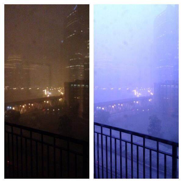
View image on Twitter
Left side normal, right side lighting. Wow.

 
11:01 p.m. CDT Monday: A wind gust of 86 mph was reported in Lowell, Indiana by mesonet.
10:15 p.m. CDT Monday: Wind gusts up to 82 mph in Bolingbrook, Illinois, reports NWS spotter.
9:39 p.m. CDT Monday: Another line of storms is about to blast through the Chicago area.

9:28 p.m. CDT Monday: Wind gust of 77 mph was measured in Guymon, Oklahoma, according to NWS observation.
8:56 p.m. CDT Monday: Funnel cloud spotted near Green Castle,Missouri, reports NWS trained spotter.
8:36 p.m. CDT Monday: Flooding and cars stalled in streets reported in Freeport, Illinois, reports emergency manager.
8:20 p.m.CDT Monday: Tornado reported on the ground along highway H near I-35 near Gilman City, MO, reports law enforcement.
8:10 p.m. CDT Monday:


View image on Twitter
Gotta love summers in Chicago


7:55 p.m. CDT Monday 


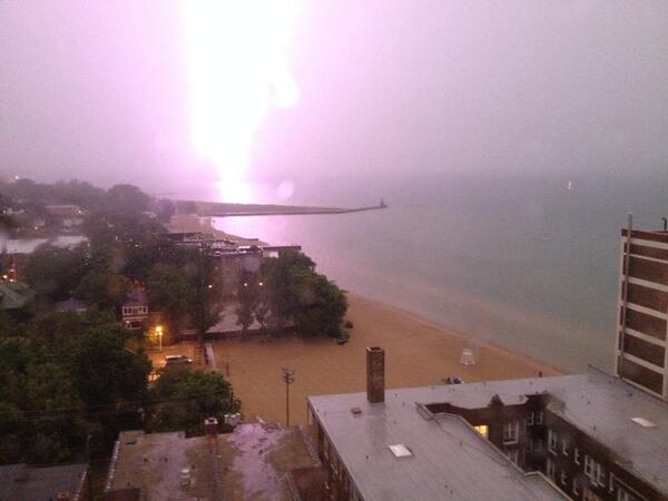
View image on Twitter
Lightning strike far to the north of .


7:50 p.m. CDT Monday:
7:33 p.m. CDT Monday:

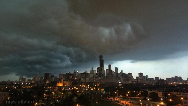
View image on Twitter
Here's the storm front passing over the skyline . Wow! >


7:17 p.m. CDT Monday: Chicago, Illinois:
6:45 p.m. CDT Monday: Approximatley 70,000 Alliant Energy Iowa customers are currently without power, reports the utility.
6:13 p.m. CDT Monday: Flooding in Madison, Wisconsin.
(Photo/Twitter user Alyssa Reif @AMarieR5)
6:09 p.m. CDT Monday:
5:30 p.m. CDT Monday: Derecho moving eastward towards Chicago, expected to arrive in the city within the next 90 minutes. Current radar:
4:51 p.m. CDT Monday: Heavy winds earlier this afternoon in Cedar Rapids.
(Youtube video/Forrest B. Saunders)
4:31 p.m. CDT Monday: Wind damage in Cedar Rapids, Iowa.

(Photos/Twitter user Brittany Nissen @bittymishel)
4:14 p.m. CDT Monday:
4:07 p.m. CDT Monday: Derecho Alert: Illinois, Wisconsin and Michigan.
3:49 p.m. CDT Monday: NWS spotter reports 5.34 inches of rainfall since 11 p.m. Sunday evening near Ladora, Iowa. The monthly total is 15.83 inches.
3:32 p.m. CDT Monday: From around 3 p.m. CDT Monday, looking west from Salon, Iowa.
(Photo/Twitter user Scott Sutton @scottnpd)
3:13 p.m. CDT Monday:
3:11 p.m. CDT Monday: NWS spotter reported two inches of rain in 20 minutes near Dunkerton, Iowa.
2:56 p.m. CDT Monday: NWS spotters estimated 80 mph winds or higher near Cedar Rapids. High winds were observed for more than five minutes.
2:37 p.m. CDT Monday: NWS spotters estimated 60 to 70 mph wind gusts near Marengo, IA.
2:35 p.m. CDT Monday:
2:09 p.m. CDT Monday: Semi-truck blown on I-35 one mile southeast of Bevington, Iowa.


View image on Twitter
Semi blown over on I-35 near Bevington. Follow storm updates: http://dmreg.co/1voVfNg 

1:54 p.m. CDT Monday:
1:30 p.m. CDT Monday:


View image on TwitterView image on Twitter
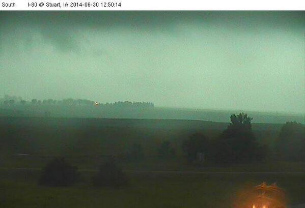
This is what is looked like just before the storm hit Stuart, IA. High winds and hail coming in.


1:25 p.m. CDT Monday;


View image on Twitter
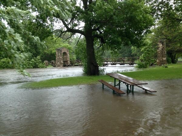
Skunk River flooding park on Broad St
 
12:53 p.m. CDT Monday: "There is a likely tornadic supercell that definitely is causing large hail about 40 miles SW of Des Moines and heading in the general direction of Des Moines," said AccuWeather.com Senior Meteorologist Frank Strait.
12:26 p.m. CDT Monday: In addition to the significant risk of tornadoes, the threat of a derecho is developing for Iowa, according to Mike Smith,senior vice president and chief innovation executive for AccuWeather Enterprise Solutions.
12:02 p.m. CDT Monday: Golf ball-sized hail near Boxholm, Iowa, the emergency manager reports.
12:00 p.m. CDT Monday: Up to 3.25 inches of rain have been recorded by an NWS-trained spotter in Linn County, Iowa, since last night. Current radar:

11:45 a.m. CDT Monday: A tornado watch has been issued from Nebraska to Iowa. Andrew Baglini explains:
11:20 a.m. CDT Monday: NWS-trained spotter in Woodbury County, Iowa, reports thunderstorm wind gusts from 60 to 70 mph. Tree limbs are reportedly being knocked down into roads.
11:00 a.m. CDT Monday: Watch our new edition of 'AccuWeather LIVE' for the latest storm updates:

10:45 a.m. CDT Monday: An inch of rain was reported in just 12 minutes in Norfolk, Nebraska.
10:35 a.m. CDT Monday: Grapefruit-sized hail now reported by NWS-trained spotter in Rockwell City, Iowa.
10:20 a.m. CDT Monday:


View image on Twitter
Hail in Harlan, IA this morning. @RustyLord


9:55 a.m. CDT Monday: Hail measuring 2 inches in diameter, about the size of a hen egg, has been reported by an emergency manager in Harlan, Iowa.
9:45 a.m. CDT Monday: According to the FAA, Chicago's O'Hare International Airport is experiencing gate hold and taxi delays as a result of the stormy weather in the Midwest.

9:25 a.m. CDT Monday:
9:15 a.m. CDT Monday: Law enforcement in Wayne County, Nebraska, reports golf ball-sized hail.
8:55 a.m. CDT Monday: A 911 call center reports flash flooding in Rhea County, Tennessee.
8:30 a.m. CDT Monday: Law enforcement in Pierce County, Nebraska, report a brief funnel cloud in the area.
8:15 a.m. CDT Monday: Benton County, Iowa, has received 2.75 inches of heavy rain so far, according to an NWS spotter.

On Social Media
Bill Verzal
bjverzal
“@breakingweather: Wind gusts up to 82 mph in Bolingbrook, Illinois, reports NWS spotter. ow.ly/yDkq0
Joanne Guthrie-Gard
jojogard
LIVE: Tornadoes, Storms Develop in Plains, Threaten Chicago Next accuweather.com/en/weather-new…
HailWATCH
hailwatch
WIND GUST 50 MPH, reported @ 06/29/2014 23:45 CDT IA, IOWA CITY(5 NW) - Zip Code: 52241 Zip P... Read more at bit.ly/1mLT8CH
23h