Published: November 8,2015
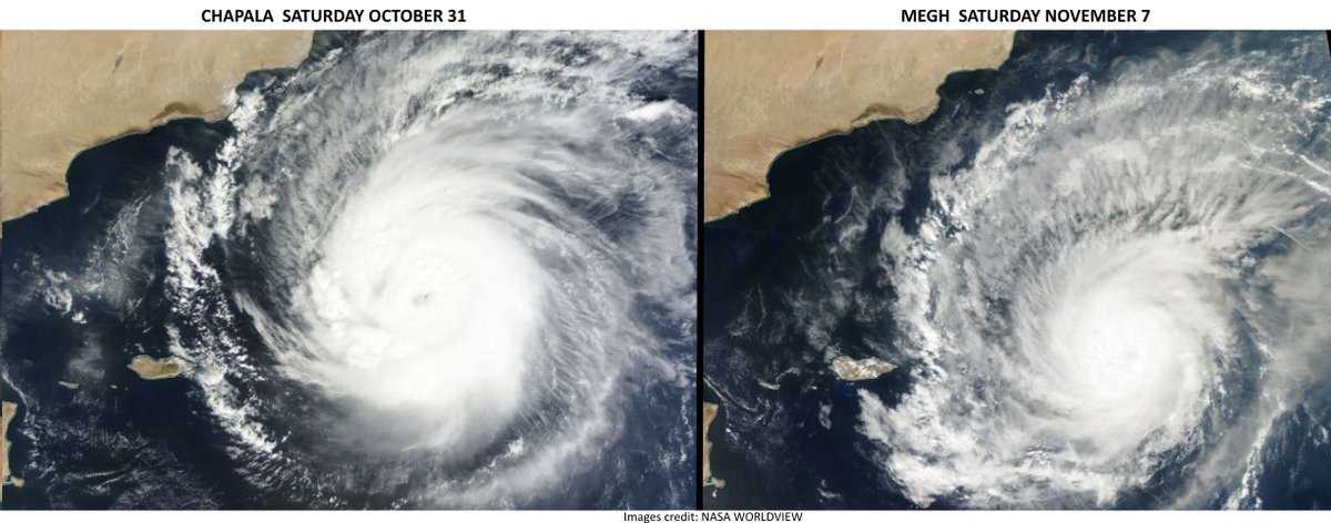
Cyclone Megh made a direct hit on Socotra Island Sunday and may track to mainland Yemen roughly one week after Cyclone Chapala made an extremely rare pass through the region, triggering destructive flash flooding. Back-to-back cyclones affecting Socotra Island within a week's time is unprecedented in the historical record (More on that below).
(CHAPALA RECAPS: A Rare, Destructive Landfall | News Reports, Photos)
According to the India Meteorological Department, the agency sanctioned by the World Meteorological Organization for issuing official tropical cyclone bulletins for the Arabian Sea, Cyclone Megh was a strong Category 2 near the time it made a direct hit on Socotra Island, an island about 150 miles east of the Horn of Africa in the central Arabian Sea that is a part of Yemen. The U.S. Joint Typhoon Warning Center (JTWC) classified Megh as a Category 3 equivalent near the time it hit Socotra Island.
Latest Location, Infrared Satellite
Forecast: Another Threat to Yemen After Hammering Socotra Island
Heavy rain leading to flash flooding, damaging winds, coastal flooding and dangerous surf will continue on Socotra with Megh into Sunday night. For the latest news on impacts in Socotra from Megh, see our news article at this link.Cyclone Megh Forecast Path
Cyclone Megh will be susceptible to dry air from the Horn of Africa and the Arabian Peninsula as it nears those land masses. As of Sunday night (EST) Megh continues to weaken due to the interaction with land and dry air.
Chapala fended off this dry air for awhile, but eventually weakened from a Category 3 to a Category 1-equivalent cyclone when it neared the coast of Yemen.
An initially less-intense, smaller Megh may not be able to fend it off as long as Chapala.
Increased wind shear may also come into play near the Gulf of Aden, as well.
The bottom line is the future of Megh in the Gulf of Aden still remains a bit uncertain at this time.
Instead of a Category 1 landfall like Chapala, Megh may be weakened to the equivalent of a tropical storm or depression by the time it reaches the south Yemen coast between Mukalla and Aden sometime Tuesday.
Or, Megh may move quickly enough and maintain enough of its core circulation to landfall as a still somewhat healthy Category 1 equivalent cyclone, with more locally heavy rainfall near and inland from the south Yemen coast.
Chapala's core of hurricane-force winds passed near, or just west of Yemen's fifth largest city, the coastal, war-ravaged port of Al Mukalla, with a population of about 300,000.
The south coast of Yemen is fronted by hills and mountains. Persistent rainbands from Chapala slamming into those mountains may have produced 3 to 16 inches (75 to 400 mm) of rain, according to satellite rainfall estimates from NASA's Global Precipitation Measurement mission.
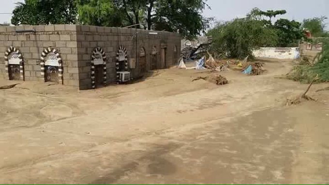
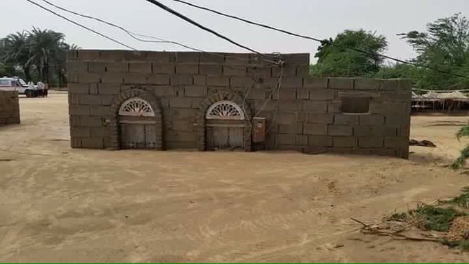
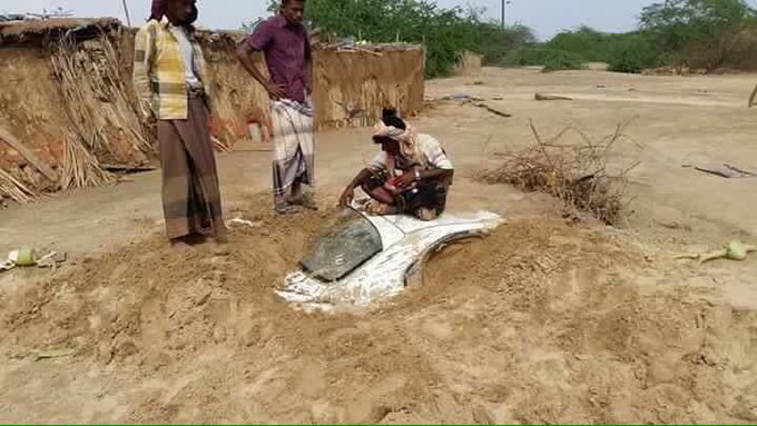
Rivers running from these mountains that are normally dry, known locally as wadis, saw rapid rises with rainfall of this magnitude, with destructive mudslides and debris flows.
Shabwa in the wake of #Chapala. Homes and vehicles lost to the mud. via @n9m3ss0uth3rn
The United National High Commissioner for Refugees said Friday that 1,775 families were displaced by Chapala in Hadramaut, Shabwah and Al Maharah. Hundreds more were displaced on Socotra Island, according to UNHCR.
"Jilaa, a village of around 1,150 persons in Shabwah governorate was completely washed away," said UNHCR spokesman Andreas Needham Friday.
Emirates247.com Tuesday reported 117 homes were completely destroyed, and another 612 homes were partially damaged on the island, according to a local authority in damage estimation. An estimated 203 fishing boats were either destroyed or missing, and hundreds of dead animals and trees were still lining the streets as of November 3.
(MORE: Why Tropical Cyclones Are Named)
Unprecedented Back-to-Back Cyclones
There was no record of a cyclone of Category 4 strength or stronger tracking as far south in the Arabian Sea prior to Chapala.You may wonder, then, if there is any record of back-to-back cyclones within roughly a week's time affecting this region of the Arabian Sea.
Cyclone Twelve passed over the island on Oct. 24, 1972. Less than one month later, Cyclone Thirteen fizzled southeast of Socotra on Nov. 21.
So, it's safe to say back-to-back cyclones affecting Socotra Island within a week's time is unprecedented in the historical record.
According to NOAA, prior to Chapala, there had been 16 cyclones of record that tracked within 200 nautical miles of the mouth of the Gulf of Aden.
No more than one had done so in any year, so that would be another record-setter if Megh can hold together as a cyclone into the Gulf of Aden.
(MORE: Hurricanes in Strange Places | Strange Things in the Tropics in 2015
(NOAA Historical Hurricane Tracks)
Coincidentally, just over a year ago, back-to-back hurricanes struck Bermuda six days apart, an unprecedented such occurrence there.
Despite all this, Arabian Sea tropical cyclones are not as unusual as they sound.
Each year, an average of one to two tropical cyclones form in the Arabian Sea, according to a 2011 climatology study by Amato Evan and Suzana Camargo.
These cyclones are most likely to form in two periods: May-June and October-November. The mid-late summer period is typically not favorable, thanks to increased wind shear from the wet phase of the Asian monsoon.
(MORE: Where the Season Peaks Twice)
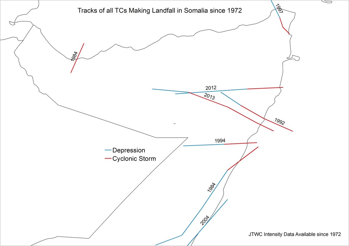
Somalian tropical cyclones aren't even as rare as they may sound, according to Colorado State University tropical expert, Dr. Phil Klotzbach.
Seven cyclonic storms (>= 34 kts) and one depression have made landfall in Somalia since 1972.
Gonu claimed 100 lives in Oman, Iran and the United Arab Emirates and was responsible for $4 billion in damage, according to the Evan and Camargo study.
Almost exactly three years later, Cyclone Phet alarmingly intensified to a Category 4 equivalent cyclone, before weakening to a Category 1 storm upon making landfall on the eastern tip of Oman, east of the capital city of Muscat.
In May 1999, Cyclone ARB 01 slammed into Pakistan near Karachi as a strong Category 3 equivalent storm, killing at least 700 in Pakistan. This was the strongest tropical cyclone on record to hit Pakistan.
(MORE: Deadliest Tropical Cyclones in World History)
In the limited historical record, however, strong cyclones in the Arabian Sea are more rare than other basins, due to the proximity of dry air from the Arabian Desert, the aforementioned increased wind shear during the wet phase of the Asian monsoon, and the basin's overall small size.



No comments:
Post a Comment