By Kevin Byrne, AccuWeather staff writer
By Brian Lada, AccuWeather meteorologist and staff writer
By Courtney Barrow, AccuWeather staff writer
August 26,2017, 11:46:59AM,EDT
As of 10:45 a.m. CDT Saturday, this reports story is no longer being updated. For continuous live updates of Harvey, click here.
Hurricane Harvey made landfall as a major hurricane between Port Aransas and Port O'Connor, Texas, on Friday night and will continue to batter the Gulf Coast throughout the weekend.The storm is expected to bring catastrophic and life-threatening flooding with widespread rainfall amounts of 10-20 inches. Some locations could exceed 2 feet of rain.
Rockport, Texas, just north of Corpus Christi, was one of the hardest-hit areas. Multiple buildings were damaged and the local high school reportedly collapsed. More than 100 people were evacuated from a hotel that sustained severe damage. Hundreds of thousands lost power throughout the state.

RELATED:
Torrential rain to evolve into flooding disaster as major Hurricane Harvey makes landfall over Texas
Why you should evacuate ahead of a hurricane
6 ways to prepare now for hurricanes
9:15 a.m. CDT Saturday: The Coast Guard is responding to three tugboats in distress near the Lydia Ann Channel near Port Aransas, Texas, Saturday. Mayday notifications were received from crewmembers of the tugboats Belle Chase, Sandy Point and Sabine Pass.
"Coast Guard Air Station Corpus Christi directed the launch of two MH-65 Dolphin helicopter aircrews that are en route for rescue," Coast Guard officials said in a statement.
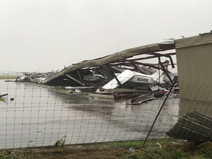
8:28 a.m. CDT Saturday: As daylight emerges over coastal Texas, more damage photos are beginning to emerge. Major damage is being reported around Rockport including at the town's airport.
Rockport airport severe damage.
7:48 a.m. CDT Saturday: In Corpus Christi, traffic lights are out and there is lots of debris strew on the roads and downed power lines, according to law enforcement.

7:20 a.m. CDT Saturday: More than 63,000 CentrePoint Energy customers are without power in the Houston area. Houston city officials have told residents to be aware of changing conditions and to avoid travel at this time.
Tornado damage has been reported in neighboring communities, officials said.
6:00 a.m. CDT Saturday: A possible tornado tore through Sienna Plantation, Texas, early Saturday morning. There are reports of roofs blown off and extensive tree damage.
4:50 a.m. CDT Saturday: The San Bernard River near Sweeny, Texas, is projected to crest well above record flood stage later next week, according to hydrologists at the National Weather Service. The projected crest of 33.8 feet would beat the previous record crest from 1998 by nearly 10 feet.

4:20 a.m. CDT Saturday:
According to a MesoWest weather station in Victoria, Texas, 16.43 inches of rain has fallen in the past 24 hours.
A fire on Bolivar Peninsula destroyed at least three homes late Friday night. The flames were exacerbated by Harvey's high winds. No word yet on any injuries or if any residents were home at the time of the fire.
3:30 a.m. CDT Saturday:
A second shelter is being prepared for Harvey evacuees at the Tommie M. Allen Recreation Center in Dallas. No time has been set for the shelter to be opened.
A boat crew is reportedly missing after their boat sank near Port Aransas, Friday afternoon. The wife of one of the crew members says she was in contact with her husband until 11 p.m. Friday night, but hasn't heard from him since. The man was able to share video aboard the boat before he and his wife lost contact.
3:00 a.m. CDT Saturday: Harvey has weakened to Category 2 hurricane with maximum sustained winds of 110 mph.
2:30 a.m. CDT Saturday:
2 a.m. CDT Saturday: According to AEP Texas, about 162,000 customers are without power in the southeastern part of the state as of 1 a.m.
1:10 a.m. CDT Saturday: Isolated tornadoes are possible along the outer rainbands of Harvey. Two tornado warnings are in effect southwest of Houston for Fort Bend and Brazoria counties until 1:30 a.m. CDT. Brief tornadoes could spin up at any time throughout the circulation of the storm as Harvey continues to push inland.
An emergency manager reported home damage and minor injuries from a confirmed tornado in Missouri City, Texas. A deputy responding to the scene was blown off the road due to the high winds.
MAJOR TORNADO DAMAGE in Sienna Plantation (Missouri City) roofs blown off, lots of big trees down. @abc13houston #HurricaneHarvey
1 a.m. CDT Saturday: Hurricane Harvey has been downgraded to a Category 3 storm with sustained winds of 120 mph. Despite weakening, Harvey will continue to pose significant risk to lives and property across southeastern Texas, with coastal flooding, strong winds and extremely heavy rainfall.
12:45 a.m. CDT Saturday:
Rainfall totals are quickly rising in much of the southeastern part of the state. Angleton, Texas, received 7.10 inches; Palacios, Texas, received 6.15 inches; and Victoria, Texas, has had 4.33 inches since early Friday morning.
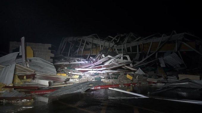
BREAKING: Massive damage to Rockport-Fulton HS after #Harvey makes landfall.
12 a.m. CDT Saturday: Multiple reports have surfaced of a makeshift hospital being set up in a jail in Rockport after parts of a nearby senior center collapsed. Rockport Courthouse has also reportedly faced severe damage.
Local media confirms a large portion of the Rockport High School has collapsed, but the building is not completely gone. No word yet on injuries.
11: 00 p.m. CDT Friday: Large fishing boats have been pushed inland by storm surge in Port Aransas, Texas, according to local law enforcement. Significant damage has occurred along the waterfront and shipping channel.
An Ace Hardware store has reportedly taken on severe damage in Rockport.

10:30 p.m. CDT Friday:
There are unconfirmed reports of injuries as Rockport High School collapsed due to high winds.
Corpus Christi has issued a boil water notice for the area as Harvey continues to rage.
According to local law enforcement, the Fairfield Inn at Rockport, Texas, has suffered severe damage. One-hundred and twenty eight people have been evacuated from the hotel and sent to a hurricane shelter.
10:00 p.m. CDT Friday: Hurricane Harvey has made landfall between Port Aransas and Port O'Connor, Texas, with sustained winds of 130 mph.
Harvey is the first Category 4 hurricane to make landfall in Texas since Hurricane Carla in 1961.

9:50 p.m. CDT Friday: Several buildings have collapsed in Rockport, Texas, with people trapped inside, emergency managers report.
The eye of Harvey is beginning to move over Rockport, allowing winds to temporarily decrease. However, winds will pick up once the eye wall moves back over the town.
9:00 p.m. CDT Friday: President Donald Trump signed a disaster proclamation early on Friday night which will bring financial assistance and emergency services to areas impacted by the hurricane.
8:00 p.m. CDT Friday: The outer part of Harvey's eye is beginning to move onshore. Landfall is likely to occur near Rockport, Texas, early tonight.

The National Weather Service office in Corpus Christi closed their hurricane shutters in final preparations for the landfall of Harvey.
7:20 p.m. CDT Friday: Wind damage is starting to become more widespread along the coast of Texas as the eye of Harvey nears land.
Winds have gusted past 100 mph at Aransas Pass, Texas, with higher gusts likely in the coming hours.
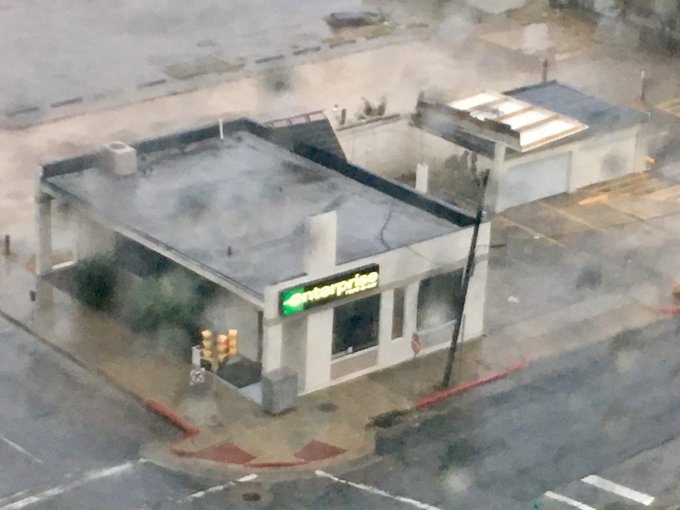
#DAMAGE: Roof of Enterprise parking area has collapsed in downtown in Corpus Christi. #Harvey set to make landfall in 1-2 hours
6:00 p.m. CDT Friday: Harvey has been upgraded to a Category 4 hurricane just hours before making landfall near Corpus Christi, Texas.
Sustained winds are 130 mph with the center of the eye of the storm just 45 miles east of Corpus Christi.
If Harvey makes landfall as a Category 4 hurricane, it would be the first Category 4 hurricane in the United States since Hurricane Charley in 2004.

5:15 p.m. CDT Friday: An extreme wind warning has been issued for areas just north of Corpus Christi, Texas. People in the area of the high wind warning are urged to treat these winds as if there were a tornado approaching.
The extreme wind warning includes southwestern Calhoun County, Aransas County, east-central Nueces County, eastern San Patricio County and central Refugio County.
Corpus Christi police have been ordered to stop responding to emergency calls until conditions improve. The eye of Harvey is just several miles east of the city.
5:00 p.m. CDT Friday: AccuWeather Extreme Meteorologist Reed Timmer deployed his tornado probe in Rockport, Texas, to collect weather data about Hurricane Harvey as it nears landfall.
4:15 p.m. CDT Friday: Tornado damage has been reported near Galveston, Texas, by a National Weather Service trained spotter after a thunderstorm moved through the city. The storm was associated with a band of rain from Harvey.
According to the spotter, the tornado damaged a McDonald's sign at the intersection of Seawall Boulevard and Broadway Avenue.
3:45 p.m. CDT Friday: Nueces County released a statement telling residents that the evacuation window has ended and it is now time to shelter in place. Emergency responders may not be able to access areas due to the strength of the storm.
“Widespread power outages and tree damage is expected, as well as damage to some structures. Power outages will probably last into next week in some areas,” AccuWeather Meteorologist Alyson Hoegg said.
Other utilities such as cell phone reception may also be impacted by the storm and may not be fixed for several days.

3:09 p.m. CDT Friday: With Harvey poised to become the first major hurricane to make landfall in the U.S. since 2005, here is a look at some of the risks it poses.

2:00 p.m. CDT Friday: Harvey is now a Category 3 hurricane with sustained winds of 120 mph. Harvey is now considered a major hurricane and is on track to become the first major hurricane to make landfall in the United States since 2005.
"Similar winds with higher gusts are expected at landfall tonight, around midnight local time," AccuWeather Meteorologist Alyson Hoegg said.
"Landfall is expected to occur just to the east of Port Aransas, Texas, over San Jose Island," Hoegg added.
A tornado watch has also been issued for part of the coast of Texas and Louisiana due to the threat of tornadoes and waterspouts associated with Harvey.
1:20 p.m. CDT Friday: Harvey remains a powerful Category 2 hurricane with sustained winds of 110 mph, according to the National Hurricane Center in their 1 p.m. CDT advisory.
Preparation for the storm should be rushed to completion as tropical storm conditions are occurring along part of the coast of Texas. Storm surge is also starting to inundate parts of the coast.

11:45 a.m. CDT Friday: Impacts from Harvey are already being felt across mainland Texas, as the outer rainbands are moving across the lower and middle Texas coasts.
Tropical-storm-force winds have been registered at the Corpus Christi Naval Air Station. The first tornado warnings were issued for central Matagorda County.
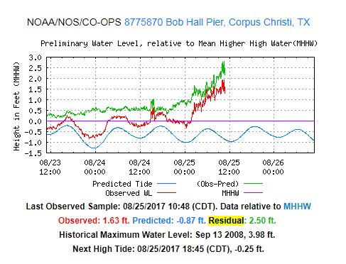
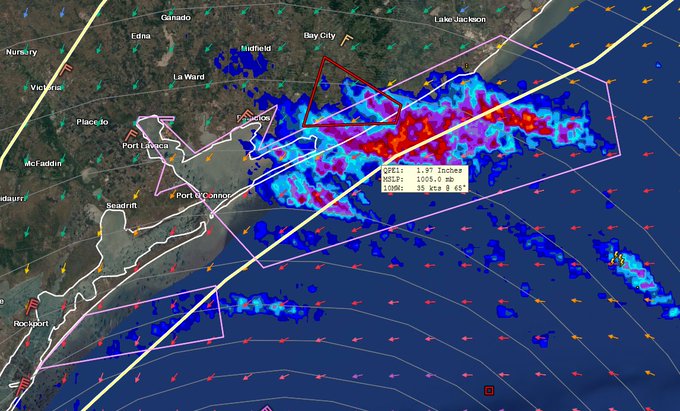
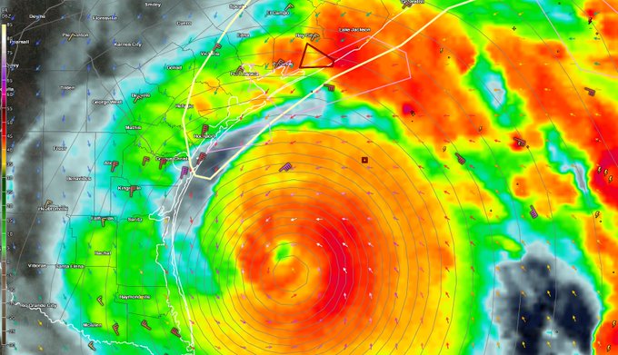
Waves >20 ft either side of the storm. 1st tornado warning with 2"/hr rainfall. 2.5 ft storm surge already at Corpus Christi #harvey
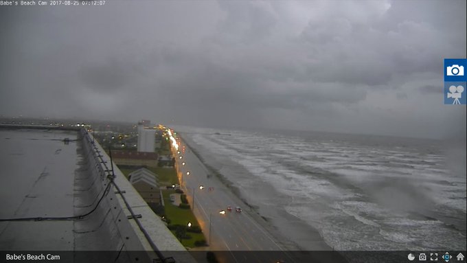
Dangerous rip currents, large surf & elevated water levels are here per @GalvestonCom . Stay out of the water & off the jetties. #houwx



No comments:
Post a Comment