Invest 99-L, a tropical disturbance we've monitored since last week, may have a dangerous future in store for the southeast U.S. and Gulf coasts this weekend into next week.
(MORE: What is an Invest?)
For now, 99-L can be seen on radar from MeteoFrance moving through the Leeward Islands.

Invest 99-L Infrared Satellite Image
(MORE: Hurricane Central)
Caribbean Impact
One factor that may be holding the further consolidation of convection into a surface low-pressure center is some wind shear, namely, the change in wind speed and/or direction with height, north of 99-L.
Current Satellite, Wind Shear
Regardless of development, this tropical wave will have one primary impact in its brush with the Caribbean basin, locally heavy rainfall.
(MORE: Why Tropical Waves Are Important During the Hurricane Season)
Rainfall totals of 1-3 inches (locally higher) are expected through Thursday from Puerto Rico to Hispaniola.

Caribbean Rainfall Forecast Through Friday
A tight consensus of our guidance suggests
the disturbance should continue in a general west or west-northwest
trajectory the next several days.
(MORE: Three Things to Know About Spaghetti Model Forecasts)

Forecast Model Tracks: Invest 99-L
(MORE: Three Things to Know About Spaghetti Model Forecasts)

Forecast Model Tracks: Invest 99-L
Southeast, Gulf Coast Threat
Beyond that, this system, in whatever form it's in, should arrive in the southeast or central Bahamas by Friday or Saturday.Once it reaches this area, the environment may feature low-enough wind shear and sufficient moisture to allow a tropical depression or storm to finally form, if it hadn't done so already.
By this time, upper-level high pressure should be established over the southern Appalachians eastward to the coast of Virginia and North Carolina.
 Potential
steering flow in the upper-atmosphere late in the week/weekend. Upper
high could steer the system west once it's near the Bahamas.
Potential
steering flow in the upper-atmosphere late in the week/weekend. Upper
high could steer the system west once it's near the Bahamas.(MORE: Where Every U.S. Hurricane Has Hit Since 1985)
With that upper-level high in place, this system could then get pushed into the Gulf of Mexico, with the potential for a second landfall somewhere along the Gulf Coast next week, possibly as a hurricane.
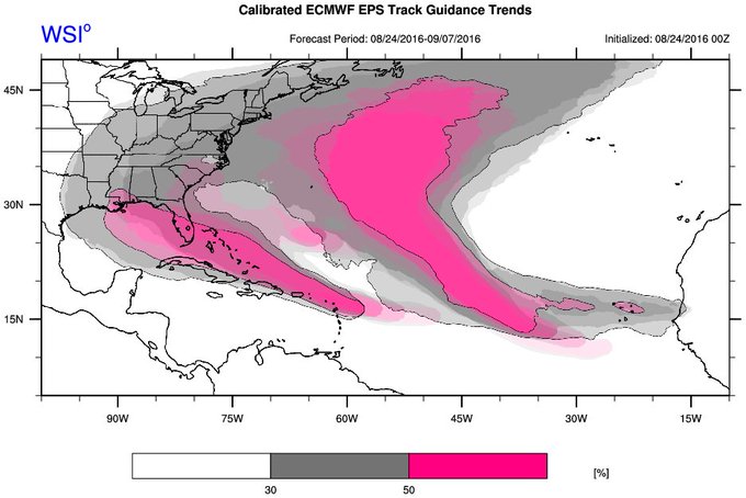
This "second landfall as a Gulf Coast hurricane" scenario has been an increasing, important trend among multiple ensemble models over the past day or so.
(MORE: Most Intense U.S. Landfalls Have Happened in a 17-Day Period)
Last 4runs of our Calib. ECMWF Ens shifting westward w/Gulf of Mexico track for #99L. Most recent run black outlines
However, the aforementioned upper-level high over the East into next week make those scenarios less probable.
It is simply too early to make a definitive call, especially since the tropical depression hasn't even formed yet.
For now, if you have interests anywhere along the Southeast and Gulf coast, from Texas to Florida to the Carolinas, check back with us at weather.com for any important forecast changes in the days ahead.
(FORECAST: Nassau, Bahamas | Miami)
Regardless of Invest 99-L's future, now is a good time to make sure you have a plan before a hurricane hits.
Jonathan Erdman is a senior meteorologist at weather.com and has been an incurable weather geek since a tornado narrowly missed his childhood home in Wisconsin at age 7.


No comments:
Post a Comment