Published: August 1,2016
Invest 97-L is churning west through the Caribbean and is likely to become Earl early this week. Here are four things to know about this system.
(FORECAST: Invest 97-L)
1. Threat to U.S. Is Low
 High pressure in the south-central U.S. should steer the system towards Belize, Mexico late this week.
(MORE: What is an Invest?)
The steering will be influenced by the clockwise wind flow around an area of upper-level high pressure over the south-central U.S. That should keep the system squashed to the south, most likely pushing it into the Yucatan Peninsula, and possibly northeast Mexico thereafter.
That said, this is still several days away, so we'll monitor for any possible changes to this thinking.
We should also note that this system could bring a surge of moisture into south Texas, enhancing rainfall there even with the center of it staying well south. Rip currents could also be a potential threat on the Gulf Coast towards next weekend.
2. It Would Be Seventh Time Earl Has Been Used as Atlantic Name
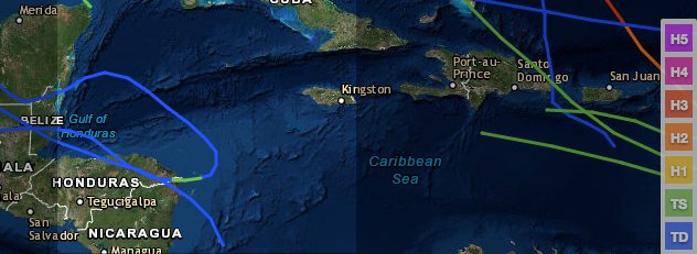
 Path of Hurricane Earl from Aug. 25 - Sept. 4, 2010.
Earl was first used in 1980, and then again every six years thereafter: 1986, 1992, 1998, 2004 and 2010.
Atlantic hurricane and tropical storm name lists repeat every six years, unless one is so destructive and/or deadly that the at World Meteorological Organization committee votes to retire that name from future lists.
(MORE: Retired Atlantic Names)
The 1998 version of Earl hit the U.S. as a Category 1 hurricane in Florida's Big Bend region, resulting in significant storm surge flooding.
In 2010, Earl was a close call for the U.S., passing just off the coast of North Carolina's Outer Banks as a hurricane. Even though Earl passed well off the coast, it still brought storm surge flooding to North Carolina along with large, battering waves to much of the East Coast.
3. Storm Is Rarity for Western Caribbean in Recent Years
The western Caribbean, a swath from roughly Jamaica to the Yucatan Peninsula, has been very quiet the last several years. Just one tropical storm has affected that region of the Atlantic basin since the start of 2013.
W. Carib. Sea (Jamaica -> Yucatan) has been a dead zone last 3+ #hurricane seasons. Only 1 TS 2013 - July 2016.
This is quite a change from the previous three-year period (2010-2012), which had about 10 named storms in that region.
4. Storm Has Become More Organized
Invest 97-L was first designated by the National Hurricane Center (NHC) last Thursday as an area to watch for possible development into a tropical depression or storm.Since then, it's been hauling westward at up to 30 mph as a tropical wave. That fast forward movement in combination with dry air helped limit its development potential late last week and over the weekend.
(MORE: What is a Tropical Wave?)

Current Satellite


No comments:
Post a Comment