Published: August 18,2015
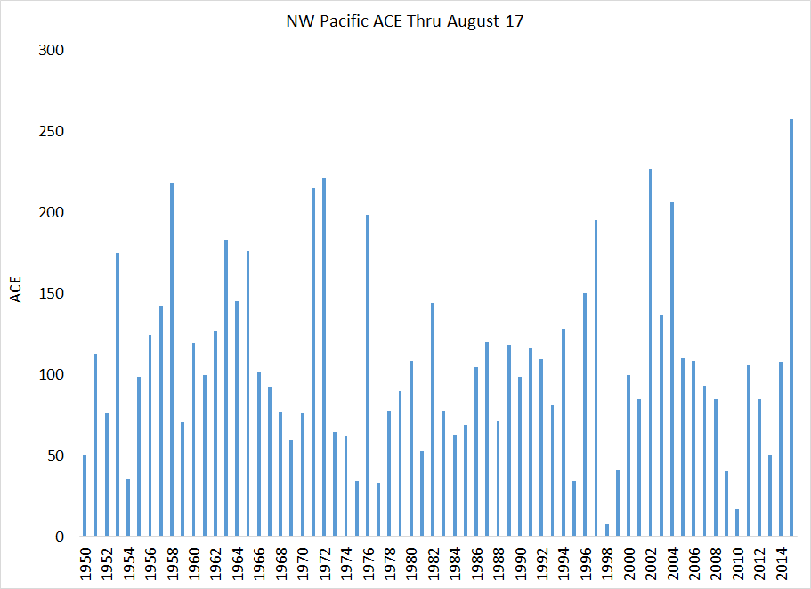
According to Dr. Phil Klotzbach, lead author of tropical season forecasts at Colorado State University, the ACE (Accumulated Cyclone Energy) index of 257 units through Aug. 17 shatters the previous record active start to the year set in 2002 of about 227 units.
NW Pacific ACE at record high levels (257) thru 8/17 - ~30 ACE greater than 2nd place (2002).
Long-lived, intense hurricanes have a high ACE index. Short-lived, weak tropical storms, a low ACE index. The ACE of a season is the sum of the ACE for each storm and takes into account the number, strength and duration of all the tropical storms in the season.
With typhoons Goni and Atsani in the Pacific now, this number will skyrocket.
(MORE: Twin Typhoons)
These ACE index values in the western North Pacific Ocean are more than two and a half times the year-to-date average, and exceeds those from all of 2014 (254), according to Dr. Ryan Maue, atmospheric scientist at WeatherBell, who tracks global ACE index values.
Five of the storms – Maysak, Noul, Dolphin, Nangka and Soudelor – hit super typhoon status, with maximum estimated sustained winds topping 150 mph.
The potential exists for both Goni and Atsani to each reach super typhoon status.
When considering the eastern North Pacific basin, Klotzbach said the 11 Category 4 or 5 tropical cyclones this year through Sunday, Aug. 16, set a year-to-date record for the Northern Hemisphere, smashing the previous record of seven such intense tropical cyclones tied in 2014, according to records dating to 1971.
Since that time, Atsani became the year's 12th such intense tropical cyclone. This is impressive since the Atlantic basin had yet to produce a single hurricane, much less one of that intensity.
The Pacific tropical activity can be attributed, in part, to impressively warm ocean water.
"The high ACE values we've seen in the northeast and northwest Pacific basins are consistent with El Nino," Klotzbach said in early June.
El Nino is an anomalous, yet periodic, warming of the central and eastern equatorial Pacific Ocean. For reasons still not well understood, every 2 to 7 years, this patch of ocean warms for a period of 6 to 18 months.
(MORE: Strong El Nino Likely | Atlantic Season Outlook)
The eastern Pacific basin typically sees an increase in named storms during a moderate to strong El Nino thanks to diminished vertical wind shear.
The opposite is true in the Atlantic basin, since wind shear tends to increase in a moderate to strong El Nino, particularly in the Caribbean Sea.


No comments:
Post a Comment