Published: October 11,2016
It's that time of year when the West, especially the Pacific Northwest, enters a stormy pattern as a series of disturbances slide eastward off the Pacific Ocean and across the region.
The first signs of this pattern will take shape starting Wednesday night, marking the beginning of a parade of storm systems late week and this weekend. A storm system hitting the coast this weekend will be associated with the remnants of western Pacific Typhoon Songda.
(MORE: Where the Planet's Most Intense Tropical Cyclones Most Frequently Happen)
Timing the Storms
While the Northwest has enjoyed a dry, seasonable start to the week, conditions will quickly go downhill by Wednesday night. This is when the first disturbance will push ashore, bringing a period of rain followed by occasional showers into Thursday.
(MAPS: 7-Day Forecast Highs and Weather)
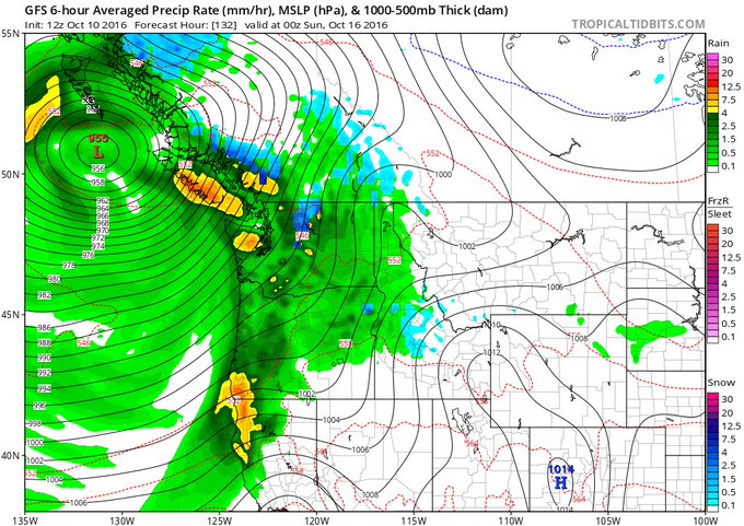
The third, and strongest, frontal system will impact the Northwest Saturday. This system will be the remnants of Typhoon Songda, so heavy rain and gusty winds are a safe bet. This disturbance's rain and wind will linger into Sunday.
Remnants of Typhoon #Songda will be 3rd storm system to impact Pac. Northwest through weekend. Intense: 955 mb. (Courtesy: @TropicalTidbits)
- Wednesday Night: A steady period of rain develops from west to east across Washington, central and western Oregon and northwest California.
- Thursday-Friday: Rain will fall across Washington, Oregon, northern and central California, Idaho, northern Nevada, western Montana, western Wyoming and northern Utah. Some very high-elevation snow is also possible from the Cascades (above pass level) into the northern Rockies. Gusty winds will impact the immediate coast and the mountains.
- Saturday-Sunday: Periods of rain can be expected across Washington, Oregon, northern and central California, Idaho, northern Nevada, western Montana, western Wyoming and northern Utah. Some higher-elevation snow is also possible in the mountains of Idaho, western Montana and western Wyoming, as well as the highest elevations of the Cascades and the northern Sierra Nevada. Once again, strong winds are expected, especially near the coast and over higher elevations.
Rain, Wind and Snow Impacts
Heavy rain could lead to isolated flooding in parts of the Northwest late this week and into the weekend. The heaviest rain is expected to fall along and near the coast, where as much as 5 to 8 inches of rain could fall through Sunday. Isolated areas could pick up over 8 inches of rain.This hefty amount of rain will yield the potential for flooding, especially in urban and poor-drainage areas. Leaf-clogged drains could also worsen the situation since leaves are slowly beginning to fall from the trees; water will not be able to adequately flow into storm drains if leaves are clogging them.
(MORE: When Does Your City See Peak Fall Color?)
Farther inland, in places like Seattle and Portland, Oregon, 3 to 5-plus inches of rain is still possible, and localized flooding can't be ruled out.
Flooding is also possible on some of the more prone rivers in the region, such as the Skokomish in western Washington.
Rainfall Forecast
The National Weather Service has posted high wind warnings in southern Oregon and northeast California for Thursday into late Thursday night where gusts 60-80 mph are expected, with the strongest winds along the immediate coast.
High wind watches are in effect for parts of the Sierra Nevada for Thursday into Friday where gusts up to 70 mph are possible. A high wind watch is also in effect for the coasts of northern Oregon and southern Washington for Thursday into Friday where gusts 65-75 mph are expected.
Another round of strong wind gusts will impact the Northwest this weekend as the remnants of Typhoon Songda move inland. Depending on the exact track of the area of low pressure in relation to the coast, the winds could be strong enough to down some tree limbs or cause power outages.
As is typical this time of year, some snow could fall over the higher elevations of the Cascades in Washington and the northern Sierra Nevada of California. It also appears some higher-elevation snow is possible in the mountains of Idaho, western Montana and western Wyoming.


No comments:
Post a Comment