Hurricane Nicole is moving over the open waters of the north Atlantic Ocean and will likely become post-tropical sometime early this week.
(MORE: Interactive Tracker For Nicole)
While no longer a land threat, dangerous surf and rip currents will likely continue for Bermuda, Atlantic Canada, and parts of the U.S. East Coast. The swells and rip current threat may increase in the Greater Antilles, Africa, and Europe in the next day or so.
Current Storm Information
Projected Path
A Rare Bermuda Major Hurricane Eye
A last-hour eastward wobble appeared to spare Bermuda the eastern semicircle of Nicole, typically the location of a hurricane's strongest winds.However, the northern, then western eyewall did not spare Bermuda, lashing the island with wind gusts over 100 mph in spots.
(LATEST NEWS: Nicole Rakes Bermuda)
In fact, the eye of Nicole moved over Bermuda midday Thursday before moving away later in the day.
No other center of a Category 3 or stronger hurricane had tracked as close to Bermuda (officially, it did not "make landfall", according to the National Hurricane Center) as Nicole's center did since an Oct. 22, 1926 hurricane. (Hurricane Fabian's eastern eyewall struck Bermuda in 2003, but its center remained about 14 miles west of Bermuda at its closest approach.)
They described the "suspended salt spray", with a "small of ripped vegetation hanging in the heavy, hot air".
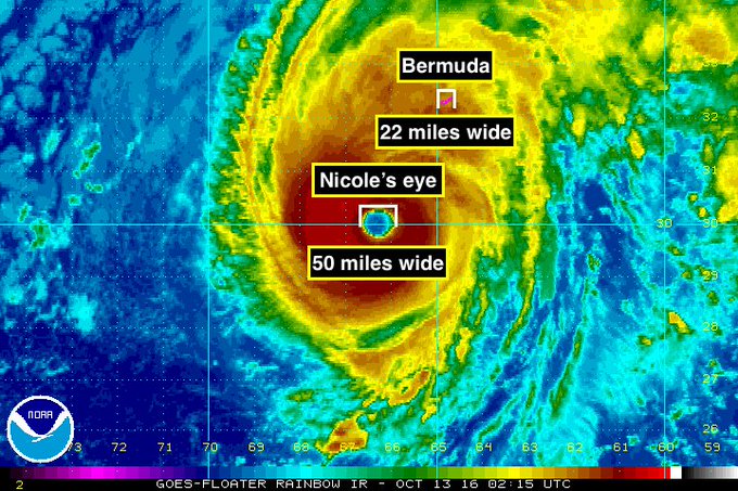
Prior to Nicole's direct hit on Bermuda, its large eye, approximately 50 miles wide at one time, was much larger than the width of Bermuda.
Perspective: Major category 4 hurricane #Nicole has an eye that is approximately 50 miles (80 km) wide, about double the width of #Bermuda.
(MORE: Hurricane Central)
Hurricanes of this intensity passing near Bermuda are exceedingly rare. Only 12 Category 3 hurricanes have tracked within 75 miles of Bermuda since 1899.
Only four October hurricanes have tracked within 50 miles of Bermuda dating back to 1950, according to Dr. Phil Klotzbach, tropical scientist at Colorado State University.
Eric Blake, hurricane specialist at the National Hurricane Center, tweeted Thursday that near-record warm sea-surface temperatures near Bermuda are contributing to Nicole's intensity.
Bermuda's Recent Hurricane History
 A yacht was turned upside down and parked on a rock outcropping in Bermuda from Hurricane Fay in October 2014.
(Chad Sellers/Wikimedia)
For
just a 21 square mile archipelago in the vast Atlantic Ocean, roughly
three-fifths the size of Manhattan, Bermuda has been very unlucky
lately.
In 2014, back-to-back
hurricanes struck Bermuda within six days: Hurricane Fay on Oct. 12,
followed by Hurricane Gonzalo on Oct. 18.
Fay was unexpectedly damaging, knocking out power to the vast majority of Bermuda’s residents.
Cleanup had to be expedited as Gonzalo
quickly followed; Gonzalo was Bermuda’s strongest and most damaging
hurricane since Fabian in 2003. Gonzalo left behind an estimated $200
million to $400 million in insured losses in Bermuda. It took two weeks
to fully restore power, there.
In early September 2003, Hurricane Fabian struck Bermuda at Category 3 intensity
in what was considered Bermuda's worst hurricane strike since 1926. An
estimated storm surge up to 10 feet inflicted heavy damage at the coast,
and roof damage was widespread in exposed areas.
According to the National Hurricane Center's final report on Hurricane Gonzalo, new construction in Bermuda is required to withstand sustained winds to about 110 mph, Category 2 intensity.


No comments:
Post a Comment