Linda Lam
Published: October 19,2016
Record warmth will be the story
in the Northeast through midweek, but by this weekend snow may be
falling in some of the higher elevations.After very warm temperatures for mid-October, a pattern change is expected late week and into this weekend that will usher in more fall-like temperatures. It may even feel more like winter to some.
(MORE: When the First Snow of the Season Typically Falls)
Warm Week
Temperatures were up to 20 degrees above average in the Northeast Tuesday and Wednesday. Many locations saw highs climb into the 70s and 80s. These very warm October temperatures set numerous daily record highs.On Wednesday, record highs were set in New York City's Central Park (85 degrees), La Guardia Airport (86 degrees) and JFK Airport (86 degrees), as well as in Philadelphia (86 degrees), Baltimore (87 degrees) and Washington D.C.'s Dulles Airport (87 degrees).
On Tuesday, Binghamton, New York, set a new daily record high of 77 degrees, as well as a record warm low of 60 degrees. Other daily record highs included Albany, New York (84 degrees); Hartford, Connecticut (84 degrees); Newark, New Jersey (85 degrees); and Baltimore, Maryland (84 degrees).
The above-average temperatures will persist in the Northeast through Thursday, but will not be quite as warm as Tuesday and Wednesday. Much of the region will top out in the 60s and 70s Thursday, with temperatures near 80 degrees as far north as Washington D.C.
(MORE: Record Warmth in the Plains, Midwest, South and East)
Low temperatures will be quite warm as well, with lows only dipping into the 50s and 60s. Given that we are halfway through fall, lows this mild are actually closer to average highs for this time of year.
What a Difference a Year Makes
Last year at this time, instead of breaking warm temperature records, it was cold enough for snow to be observed in portions of the region.Much of Upstate New York and New England recorded a trace of snow Oct. 18, 2015. Syracuse measured 0.4 inches of snow and Binghamton saw 0.1 inches.
Low temperatures were in the 20s for much of Upstate New York and New England on Oct. 18 and 19. Boston even saw its first freeze as temperatures dropped to just below the freezing mark on Oct. 19.
Big Changes Ahead
For those who prefer a warm, toasty fire to air conditioning, good news is ahead as a pattern change is on the way. The record-breaking warmth will be a distant memory by this weekend, as temperatures will drop back to closer to average.Temperatures will even be slightly below average in spots, beginning this weekend. Lows will be up to 10 degrees colder than average early next week.
(FORECAST: Buffalo, New York | Philadelphia | Boston)
Forecast Highs
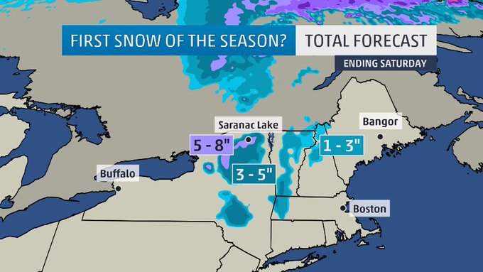
This area of low pressure will deepen and northwesterly winds will allow cold air to surge southward. This will set the stage for the possibility of some snow in the higher elevations.
Moisture from a possible tropical system could be drawn northward, which may enhance precipitation in the Northeast.
(MORE: Watching a Disturbance Near the Bahamas)
As this system slowly exits the region, some rain and snow showers may linger in the mountains through this weekend.
Wintry Forecast
Lake-effect rain showers are possible with this system as well, with the potential for a dusting of snow for the Tug Hill Plateau, especially Saturday night. Most areas, however, will see cold rain showers.
(MAPS: Weekly Planner)
Highest Peaks of #Adirondacks could see their 1st good #snow this weekend. Definitely an elevation event. #nywx
A few snowflakes may linger into Sunday night and early Monday morning in far northern New England.
High pressure is then expected to build across the region early next week, bringing drier weather and temperatures that likely will remain cool.
MORE: Unique Ways To See Fall Foliage


No comments:
Post a Comment