By:
Jeff Masters
, 4:35PM,GMT on August 27,2016
There is little new to say about the saga of tropical wave Invest 99L,
which continued to chug west-northwest at 10 mph through the
northwestern Bahamas on Saturday morning towards South Florida and the
Florida Keys. Satellite loops
late Saturday morning showed little change in the storm’s organization
and heavy thunderstorms since yesterday; 99L still lacked a
well-organized surface circulation center and the amount of heavy
thunderstorm activity was modest at best. Wind shear was a moderately high 15 - 20 knots, and 99L was still struggling with dry air, as seen on water vapor satellite imagery.
Sea surface temperatures (SSTs) remained favorable for development,
though, near 30 - 30.5°C (86 - 87°F). The Hurricane Hunter missions for
Saturday afternoon have been cancelled.

Figure 1. Latest satellite image of 99L.

Figure 2. View from a webcam on Great Exuma Island in The Bahamas at 11:36 am EDT August 27, 2016. Heavy rains and gusty winds from 99L were affecting the island. Image credit: Bonefish’s Webcam.
Track forecast for 99L
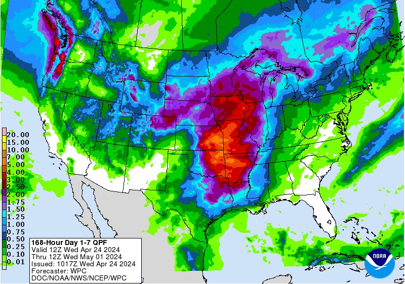
There is now model consensus among the GFS, European, and UKMET models that 99L will continue on its current west-northwest track for the next three days and not turn to the north along the west coast of Florida. A strong ridge of high pressure now covering much of the Southeast U.S. and northern Gulf of Mexico will remain in place through Tuesday, which should keep 99L on its general west-northwest track at 5 - 10 mph. The storm will pass by South Florida and the Florida Keys on Sunday, bringing heavy rains to South Florida and Cuba on Saturday afternoon through Tuesday afternoon. The 7-day precipitation outlook from NOAA’s Weather Prediction Center (WPC) calls for a large area of 3 - 7” rains across South Florida over the coming week.
Intensity forecast for 99L
The SHIPS model on Saturday morning predicted that wind shear would fall slightly, to 10 - 15 knots, Sunday afternoon and beyond. SSTs will increase to 30.5°C (87°F) by Wednesday, and mid-level relative humidity was predicted to decrease from 65% to 55 - 60%. The shear and dry air may be strong enough to continue to keep 99L from organizing into a tropical depression, as predicted by NHC: in their 8 am EDT Saturday Tropical Weather Outlook, NHC gave 99L 2-day and 5-day odds of development into a tropical depression or tropical storm of 20% and 40%, respectively.
Two of our three reliable models for predicting tropical genesis, the ECMWF and GFS, continued to show no development of 99L into a tropical cyclone over the next five days in their latest 0Z Saturday (8 pm EDT Friday) runs. Our other reliable tropical cyclone genesis model, the UKMET, continued to predict that 99L would develop into a hurricane in the central Gulf of Mexico by the middle of the week. Even though the development odds for 99L have decreased markedly since the storm moved past Puerto Rico, we should not relax our guard with this storm until the UKMET falls in line with the GFS and European models. I will continue to mistrust 99L, since a strong tropical wave moving through the Gulf during the peak part of hurricane season is always a potentially dangerous situation.

Figure 3. Latest satellite image of Invest 91L off the coast of North Carolina.
91L headed towards North Carolina
An area of disturbed weather located about 500 miles east-southeast of North Carolina is moving west-northwest towards that state at about 10 mph, and was designated Invest 91L by NHC on Friday afternoon. Satellite loops on Saturday morning showed 91L had a vigorous but elongated surface circulation, and only a limited amount of heavy thunderstorms, which were removed from the center. A few showers from 91L were affecting Bermuda on Saturday morning, as seen on Bermuda radar. Conditions favorable for development include moderate wind shear near 10 knots, and sea surface temperatures (SSTs) of 29.5°C (85°F). These SSTs were about 2 - 3°F above average, and in July 2016, were the warmest July SSTs ever recorded for that area of ocean. However, 91L is embedded in area of dry air with humidities around 40 - 45% at mid levels of the atmosphere, and this dry air was stymying development.
Forecast for 91L
Steering currents favor a west-northwesterly motion for 91L at about 5 - 10 mph over the next three days. By Monday evening, 91L will begin spreading heavy rains along the coast of North Carolina, and the storm could move ashore on Tuesday before turning northeastwards, out to sea. That doesn’t give 91L a lot of time to develop, particularly since the atmosphere surrounding the storm is expected to remain quite dry. The 8 am EDT Saturday run of the SHIPS model predicted otherwise favorable conditions for development through Tuesday, with wind shear in the moderate range, 10 - 20 knots, and unusually warm SSTs near 29 - 29.5°C (84 - 85°F.)
The Saturday morning operational runs of our three reliable models for predicting tropical cyclone genesis, the European, GFS and UKMET models, did not show development of 91L, but the GFS ensemble forecast, done by taking the operational high-resolution version of the model and running it at lower resolution with slight perturbations to the initial conditions in order to generate a range of possible outcomes, had more than 50% of its twenty ensemble members predict that a tropical depression would form. Less than 20% of the 50 members of the 00Z Saturday European ensemble model forecasts showed development. In their 8 am EDT Saturday Tropical Weather Outlook, NHC gave 91L 2-day and 5-day development odds of 30%. Since the atmosphere 91L is embedded in is so dry, this storm should not be a huge rain maker for North Carolina relative to their usual tropical storms..
New tropical wave due to emerge from Africa on Tuesday may develop
The Saturday morning operational runs of our three reliable models for predicting tropical cyclone genesis, the European, GFS and UKMET models, all predicted that a strong tropical wave expected to emerge from the coast of Africa on Tuesday would develop into a tropical depression by late next week as it moves to the west at 15 - 20 mph. In their 8 am EDT Saturday Tropical Weather Outlook, NHC did not yet give 2-day and 5-day development odds for this system, but I give the wave 5-day development odds of 10%.

Figure 4. Latest satellite image of Tropical Storm Gaston.
Elsewhere in the tropics
The tropics are very busy this weekend, but that’s what we expect this time of year. In the Atlantic, we have Tropical Storm Gaston churning the waters about 750 miles east-southeast of Bermuda. Gaston is not a threat to land, but is expected to intensify into a Category 2 hurricane as it recurves to the northeast early in the week.

Figure 5. Latest satellite image of Tropical Storm Madeline.

Figure 6. Latest satellite image of Hurricane Lester.
Hawaii is keeping a close eye on Tropical Storm Madeline, which is forecast to pass through the islands on Thursday. Close behind Madeline is Hurricane Lester, which may pass near or through the islands next Saturday.

Figure 7. Latest satellite image of Typhoon Lionrock.
Japan is watching Category 3 Typhoon Lionrock, which is expected to curve to the northwest and hit Japan as a tropical storm on Wednesday.
Bob Henson will be back with a new post by early Sunday afternoon.
Jeff Masters
Figure 1. Latest satellite image of 99L.
Figure 2. View from a webcam on Great Exuma Island in The Bahamas at 11:36 am EDT August 27, 2016. Heavy rains and gusty winds from 99L were affecting the island. Image credit: Bonefish’s Webcam.
Track forecast for 99L
There is now model consensus among the GFS, European, and UKMET models that 99L will continue on its current west-northwest track for the next three days and not turn to the north along the west coast of Florida. A strong ridge of high pressure now covering much of the Southeast U.S. and northern Gulf of Mexico will remain in place through Tuesday, which should keep 99L on its general west-northwest track at 5 - 10 mph. The storm will pass by South Florida and the Florida Keys on Sunday, bringing heavy rains to South Florida and Cuba on Saturday afternoon through Tuesday afternoon. The 7-day precipitation outlook from NOAA’s Weather Prediction Center (WPC) calls for a large area of 3 - 7” rains across South Florida over the coming week.
Intensity forecast for 99L
The SHIPS model on Saturday morning predicted that wind shear would fall slightly, to 10 - 15 knots, Sunday afternoon and beyond. SSTs will increase to 30.5°C (87°F) by Wednesday, and mid-level relative humidity was predicted to decrease from 65% to 55 - 60%. The shear and dry air may be strong enough to continue to keep 99L from organizing into a tropical depression, as predicted by NHC: in their 8 am EDT Saturday Tropical Weather Outlook, NHC gave 99L 2-day and 5-day odds of development into a tropical depression or tropical storm of 20% and 40%, respectively.
Two of our three reliable models for predicting tropical genesis, the ECMWF and GFS, continued to show no development of 99L into a tropical cyclone over the next five days in their latest 0Z Saturday (8 pm EDT Friday) runs. Our other reliable tropical cyclone genesis model, the UKMET, continued to predict that 99L would develop into a hurricane in the central Gulf of Mexico by the middle of the week. Even though the development odds for 99L have decreased markedly since the storm moved past Puerto Rico, we should not relax our guard with this storm until the UKMET falls in line with the GFS and European models. I will continue to mistrust 99L, since a strong tropical wave moving through the Gulf during the peak part of hurricane season is always a potentially dangerous situation.
Figure 3. Latest satellite image of Invest 91L off the coast of North Carolina.
91L headed towards North Carolina
An area of disturbed weather located about 500 miles east-southeast of North Carolina is moving west-northwest towards that state at about 10 mph, and was designated Invest 91L by NHC on Friday afternoon. Satellite loops on Saturday morning showed 91L had a vigorous but elongated surface circulation, and only a limited amount of heavy thunderstorms, which were removed from the center. A few showers from 91L were affecting Bermuda on Saturday morning, as seen on Bermuda radar. Conditions favorable for development include moderate wind shear near 10 knots, and sea surface temperatures (SSTs) of 29.5°C (85°F). These SSTs were about 2 - 3°F above average, and in July 2016, were the warmest July SSTs ever recorded for that area of ocean. However, 91L is embedded in area of dry air with humidities around 40 - 45% at mid levels of the atmosphere, and this dry air was stymying development.
Forecast for 91L
Steering currents favor a west-northwesterly motion for 91L at about 5 - 10 mph over the next three days. By Monday evening, 91L will begin spreading heavy rains along the coast of North Carolina, and the storm could move ashore on Tuesday before turning northeastwards, out to sea. That doesn’t give 91L a lot of time to develop, particularly since the atmosphere surrounding the storm is expected to remain quite dry. The 8 am EDT Saturday run of the SHIPS model predicted otherwise favorable conditions for development through Tuesday, with wind shear in the moderate range, 10 - 20 knots, and unusually warm SSTs near 29 - 29.5°C (84 - 85°F.)
The Saturday morning operational runs of our three reliable models for predicting tropical cyclone genesis, the European, GFS and UKMET models, did not show development of 91L, but the GFS ensemble forecast, done by taking the operational high-resolution version of the model and running it at lower resolution with slight perturbations to the initial conditions in order to generate a range of possible outcomes, had more than 50% of its twenty ensemble members predict that a tropical depression would form. Less than 20% of the 50 members of the 00Z Saturday European ensemble model forecasts showed development. In their 8 am EDT Saturday Tropical Weather Outlook, NHC gave 91L 2-day and 5-day development odds of 30%. Since the atmosphere 91L is embedded in is so dry, this storm should not be a huge rain maker for North Carolina relative to their usual tropical storms..
New tropical wave due to emerge from Africa on Tuesday may develop
The Saturday morning operational runs of our three reliable models for predicting tropical cyclone genesis, the European, GFS and UKMET models, all predicted that a strong tropical wave expected to emerge from the coast of Africa on Tuesday would develop into a tropical depression by late next week as it moves to the west at 15 - 20 mph. In their 8 am EDT Saturday Tropical Weather Outlook, NHC did not yet give 2-day and 5-day development odds for this system, but I give the wave 5-day development odds of 10%.
Figure 4. Latest satellite image of Tropical Storm Gaston.
Elsewhere in the tropics
The tropics are very busy this weekend, but that’s what we expect this time of year. In the Atlantic, we have Tropical Storm Gaston churning the waters about 750 miles east-southeast of Bermuda. Gaston is not a threat to land, but is expected to intensify into a Category 2 hurricane as it recurves to the northeast early in the week.
Figure 5. Latest satellite image of Tropical Storm Madeline.
Figure 6. Latest satellite image of Hurricane Lester.
Hawaii is keeping a close eye on Tropical Storm Madeline, which is forecast to pass through the islands on Thursday. Close behind Madeline is Hurricane Lester, which may pass near or through the islands next Saturday.
Figure 7. Latest satellite image of Typhoon Lionrock.
Japan is watching Category 3 Typhoon Lionrock, which is expected to curve to the northwest and hit Japan as a tropical storm on Wednesday.
Bob Henson will be back with a new post by early Sunday afternoon.
Jeff Masters
No comments:
Post a Comment