Published: November 1,2015
Chapala weakened slightly to a Category 3 equivalent storm on the Saffir-Simpson Hurricane Wind Scale on Sunday evening (mainland U.S. time). It had rapidly intensified to a high-end Category 4 early Friday and remained in that Category through most of Saturday.
Cyclone Chapala: Current Status
(MORE: Why Tropical Cyclones Are Named)
Warmer-than-average Arabian Sea water along its path had, in part, allowed for Chapala is intensify so rapidly.
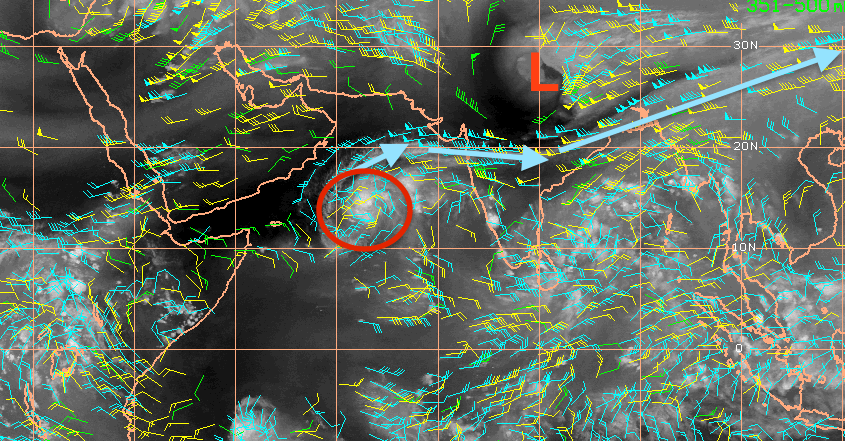
Impressive outflow channel N of Cyclone #Chapala. Shows the fine line between being sheared apart & possible RI.
The eye of Chapala has already passed by Socotra, just to the north of the island, where flooding rain and damaging winds were reported. The island has likely not experienced a cyclone of hurricane-equivalent intensity since 1922.
(MORE: Cyclone Chapala Lashes Socotra with Flooding, Damaging Winds)
Cyclone Chapala's Forecast Path
Tropical cyclones that do near the Arabian Peninsula often ingest dry, desert air and weaken before making landfall, if they do at all.
In this case, we expect Chapala to make landfall as a weaker, possibly much weaker cyclone than its maximum intensity over the Arabian Sea. Small tropical cyclones can both intensify rapidly and weaken rapidly.
However, Chapala may still be a formidable cyclone of at least Category 1 intensity at landfall, an extremely unusual occurrence for Yemen. (More on that below.)
Apart from wind, battering waves and storm surge, the threat of heavy rainfall is this normally arid climate is particularly alarming.
Chapala has the potential to dump at least 3 to 4 times the average yearly rain in just a day or two over parts of eastern Yemen and perhaps southwest Oman. Average rainfall along the southern Yemeni coast is 2 inches (50 millimeters) or less, according to the University of Texas' Perry-Castañeda Library Map Collection.
(WEATHER UNDERGROUND: Dr. Jeff Masters and Bob Henson on Historic Cyclone)
Rainfall Forecast: Cyclone Chapala
(INTERACTIVE: Oman/Yemen Coast in the Path of Chapala)
Rivers running from these mountains that are normally dry or feature very low flow would see rapid rises with rainfall of this magnitude. Destructive and deadly mudslides, debris flows, and flash flooding is likely immediately before, and sometime after landfall of Chapala in central and eastern Yemen.
In short, Chapala may be one of Yemen's costliest natural disasters on record.
We may never know, however, exactly how much rain falls or how strong the winds blow as Chapala makes landfall. Yemen has been beset by violent conflict in recent years, disrupting the electrical grid and communication networks across the country. As a result, weather observations most of us take for granted are nearly non-existent.
Yemen has eight official synoptic weather observation sites, charged with reporting weather conditions at least once every six hours. Each site should have submitted 124 six-hourly reports in October, but six of them sent none at all, one site sent just one observation, and the other eked out just 13 of its 124 required reports.
Furthermore, much of the region expected to take a direct hit is already in the midst of a humanitarian crisis. According to the United Nations, the area expected to take a direct hit (the governorate of Hadramaut) is already at "crisis" level, with 106,900 residents displaced by war and conflict.
Most of the areas to the west of Hadramaut are classified in an even more dire "emergency" status, with widespread food shortages and more than 2 million people displaced from their homes. More than 500,000 children are believed to be at risk of severe acute malnutrition, according to the U.N.
Unprecedented Landfall?
You may wonder how often "tropical cyclone" and the "Arabian Peninsula" appear in the same sentence. How unusual could Chapala be?First, hurricane specialist Michael Lowry says the head of the Cyclone Warning Division at the India Meteorological Department cited two "severe cyclonic storms" - those with winds of at least 55 mph - made landfall in Yemen in May 1959 and May 1960.
Weather Underground's Dr. Jeff Masters says Tropical Depression Three in 2008 claimed 90 lives and was responsible for $400 million in damage.
(WUNDERBLOG: Cyclone Chapala's Yemen Threat)
Secondly, there is no record of a cyclone of Category 4 strength or stronger tracking as far south as Chapala in the Arabian Sea.
(MORE: Hurricanes in Strange Places
Despite all this, Arabian Sea tropical cyclones are not as unusual as they sound.
Each year, an average of one to two tropical cyclones form in the Arabian Sea, according to a 2011 climatology study by Amato Evan and Suzana Camargo.
These cyclones are most likely to form in two periods: from May through June and October through November. The mid-late summer period is typically not favorable, thanks to increased wind shear from the wet phase of the Asian monsoon.
(MORE: Where the Season Peaks Twice)
In June 2007, Cyclone Gonu was the most intense Arabian Sea storm on record, making landfall in Oman, then in southern Iran.
Gonu claimed 100 lives in Oman, Iran and the United Arab Emirates and was responsible for $4 billion in damage, according to the Evan and Camargo study.
Almost exactly three years later, Cyclone Phet alarmingly intensified to a Category 4 equivalent cyclone, before weakening to a Category 1 storm upon making landfall on the eastern tip of Oman, east of the capital city of Muscat.
In May 1999, Cyclone ARB 01 slammed into Pakistan near Karachi as a strong Category 3 equivalent storm, killing at least 700 in Pakistan. This was the strongest tropical cyclone on record to hit Pakistan.
(MORE: Deadliest Tropical Cyclones in World History)
In the limited historical record, however, strong cyclones in the Arabian Sea are more rare than other basins, due to the proximity of dry air from the Arabian Desert, the aforementioned increased wind shear during the wet phase of the Asian monsoon, and the basin's overall small size.


No comments:
Post a Comment