Monday, October 31, 2016

Brief warmup to develop in northeastern US at midweek

By Brett Rathbun, AccuWeather.com Meteorologist
October 31,2016; 12:08PM,EDT
 
 
Another warmup will take shape over the northeastern United States at midweek.
Clear skies on Monday night will yield temperatures below freezing across much of the interior Northeast and portions of the mid-Atlantic. Those heading out for Halloween festivities will want to dress warmly.
"Following a chilly Monday night into Tuesday morning, the return of warmer air will be on the horizon," AccuWeather Meteorologist Matt Rinde said.
Temperatures from Washington, D.C., to Boston early in the week will hover between 15 and 25 degrees Fahrenheit lower than over the weekend.
Despite the cooler weather, high pressure will bring afternoon sunshine across the region through Tuesday.
Highs through Tuesday will range from the 40s and 50s from upstate New York into New England, to the 50s and lower 60s across the mid-Atlantic.
RELATED:
US winter forecast: Frequent snow to blast Northeast
5 weather threats to be wary of during the fall
Check AccuWeather MinuteCast® for your location

This cool air mass will be short-lived as another warmup will arrive by the middle of the week.
"A considerably milder air mass will reach the East by Wednesday," Rinde said.
The warmer air will stretch across locations west of the Appalachians by Tuesday and reach the rest of the mid-Atlantic and Northeast on Wednesday. Highs at the peak of the warmth will be similar to those from the weekend.

Highs will again reach into the 70s across much of the mid-Atlantic and into the 60s across southern New York and New England. Highs will hit in the 50s across northern New England.
However, the warm spell will be brief.
"An approaching storm will lead to the development of showers and thunderstorms during Thursday afternoon from northern Virginia into southern New England, some of which could contain damaging winds," Rinde said.

Those along the Interstate-95 corridor from Boston to New York City and Washington, D.C., will want to keep an eye to the sky for rapidly changing weather conditions.
Additional waves of colder air will make brief appearances to the Northeast for much of November and into December with brief warmups in-between.

Relentless heat to aggravate Southeast drought as rain remains absent

By Brian Thompson, Meteorologist
October 31,2016; 11:44AM,EDT
 
 
No rain is in sight for most of the Southeast through the opening days of November, thanks to a persistent warm and dry pattern.
The ongoing stretch of warmth and dryness in the region will spell bad news for the worsening drought.
Cities such as Pensacola, Florida, as well as Birmingham and Mobile, Alabama, are likely to end up with no measurable precipitation during the month of October.

The dry weather has been accompanied by record-breaking warmth, which will continue for much of this week.
Atlanta will likely set a new record for the warmest September through October period, on the heels of the city's second warmest summer.
This chart displays stats through Oct. 30, 2016.
"The abnormal warmth contributes to more moisture evaporating out of the soil. When the moisture does not get replenished, it's like a vicious cycle," AccuWeather Meteorologist Mike Doll said.
Birmingham, Alabama, has not received measurable rainfall since Sept. 18.
The city will only have received 0.68 of an inch of rain for the months of September and October, combined. That is just 9 percent of what Birmingham typically receives over the two-month span.

According to the U.S. Drought Monitor, over 73 percent of Alabama is experiencing severe to exceptional drought conditions.
Mississippi has not fared much better. Both Jackson and Tupelo have recorded just 12 percent of what each city receives in September and October.
Drought areas across the state are affecting over 2.9 million people, U.S. Drought Monitor data reveals.
RELATED:
US winter forecast: Freeze may damage citrus crop in South
5 weather threats to be wary of during the fall
Halloween forecast: Chilly air to make a comeback in northeastern US in time for trick-or-treating

This persistent dry weather is not predicted to end anytime soon.
"Unfortunately, the jet stream pattern this week will continue to guide storm systems and moisture north of the Southeast region," Doll said.
With rainfall deficits growing deeper, several storm systems producing heavy rain will be necessary to put a significant dent in the building drought.
According to Doll, a pattern like this is not expected to materialize over the next couple of weeks.

Chilly air to dominate the first week of November across the UK

By Eric Leister, Meteorologist
October 31,2016; 11:08AM,EDT
 
 
Chilly air will surge southward across United Kingdom on Tuesday and bring a cool spell that will last into the weekend.
Temperatures will fall a couple of degrees below normal for early November.
The high in Manchester will climb to only around 10 C (50 F) on Tuesday. Similar temperatures are expected in London and the rest of southern England by Wednesday.

This cooler air will also bring an end to the widespread fog that hampered travel across much of the U.K. early in the week.
While a spotty morning shower cannot be ruled out across the Midlands on Tuesday, largely rain-free weather will prevail elsewhere across England through the middle of the week.
However, a storm will dive southward from Iceland late this week unleashing wind, rain and high-elevation snow throughout the U.K.
Rain will spread over Scotland, Northern Ireland and northern England on Thursday before reaching the Midlands and southern U.K. on Thursday night.
Showers will be scattered across the entire U.K. on Friday as the storm spins overhead.
RELATED:
United Kingdom Weather Center
MinuteCast® for your location
Interactive United Kingdom weather radar

While the storm will slowly move to the east this weekend, cold winds and blustery showers will persist.
The air will be cold enough to produce wintry showers across the higher terrain of northern England and Scotland as early as Thursday night.
The combination of gusty winds, showers and thick clouds will make it feel more like December than early November across much of the U.K. this weekend.
Depending on the strength of the storm at this time, wind gusts over 40 mph (65 km/h) are possible across southern and eastern England.
Another shot of chilly air following this storm will keep temperatures below normal into early next week.
Despite a chilly start to November, cold outbreaks are expected to be limited this winter while frequent windstorms threaten the United Kingdom.

Startup builds robot that will clear snow from your driveway

By Kevin Byrne, AccuWeather.com Staff Writer
October 31,2016; 10:23AM,EDT
 
 
Across the United States, snow has already fallen in parts of the East and West, with much more on the way as winter creeps closer.
While many will soon be forced to get out snow shovels and snow blowers to clear their sidewalks and driveways, perhaps in the not-too-distant future robots will handle that burdensome task. At least one company is already planning on it.
Kobi, a 3-in-1 autonomous robot, was unveiled in October by The Kobi Company, a startup based in New York City. The product is being described as the world's first multi-functional robot for yard work in all seasons, as it's capable of mowing the lawn and vacuuming leaves, in addition to clearing snow.
Kobi comes with a companion app, which allows the user to drive the device around their yard or driveway as well as instruct it where to blow snow. It navigates on its own thanks to built-in GPS and a variety of sensors. Wi-Fi, Bluetooth and mobile data connectivity allow Kobi to monitor the weather forecast so it knows when it will snow.
(Photo/The Kobi Company/Steven Waelbers)
Co-founder and Chief Technology Officer Steven Waelbers told AccuWeather the user is always in control of the device, meaning they can have it set to follow the snow automatically or the person handling Kobi can just turn it on when it's snowing.
Waelbers said Kobi's efficiency is increased because it clears snow in small layers, rather than waiting for it to accumulate.
"While it is still snowing, we go back and forth over the driveway and we remove small bits of snow at a time," Waelbers said.
Waelbers, along with co-founder and CEO Andrew Ewen, pointed out several key reasons why they decided it was time to construct a snow-removing robot.
RELATED:
The quest for a viral post: Social media linked to rise in avalanche fatalities in backcountry terrain
AccuWeather winter weather center
Self-driving cars: Will they be safe during bad weather?

Shoveling snow has been linked to health risks such as heart attacks and people have suffered injuries to their limbs as the result of snow blowers. Furthermore, yard work can be time-consuming. Having a robot around can allow for more free time for people to enjoy other pursuits.
"We wanna change the way people think about cleaning their snow and mowing their lawn," Ewen said. "We're moving in an age where robotics can do a lot of those tasks intelligently."
For those interested in obtaining a Kobi, the product is still in the testing phase, but it will be available for purchase in time for the 2017-2018 winter season for a price of $3,999.
(Photo/The Kobi Company)
Kobi is the latest technological advance that aims to reduce time spent on arduous yard work. In recent years, there has been a proliferation in Uber-like snow removal services where residents can simply request a driver with a snowplow through an app. Within a designate timeframe, a plow operator will then arrive at a person's home.
While Kobi is the first autonomous robotic device geared towards snow removal that will eventually hit the market, people have experimented with the idea elsewhere.
This coming January, the seventh annual Institute of Navigation Autonomous Snowplow Competition (ION ASC) will take place in St. Paul, Minnesota, with teams coming from across the U.S. and Canada to compete. The event's website states that the competition's main purpose is to design, build and operate a fully autonomous snowplow to remove snow from a designated path.
"Automated machines for snow removal will have huge benefits for people," said Michael Ward, co-founder of Stray Robotics, a robotics fabrication shop in Minneapolis. "A homeowner could employ this system and never have to go out and shovel again. Their driveway would always be clear in the mornings on their way to work and would still be clear when they get home."
Before these robotic devices become widespread, there are hinderances to identify. These include children or pets running in front of the machine or cars parking in a new area. These distractions can provide a test for developers and the computer system on a machine that was running through its task. That's why at this year's competition, Ward said they will make the entrants navigate their robots around moving obstacles.
Still, Ward said there is an untapped market, and if the Kobi is priced right and proven safe, similar products could become commonplace.
"I think the Kobi would be a tremendous help for homeowners," said Ward, a ION ASC committee member. "I really like how it has attachments for the various tasks that it can perform instead of having to buy a Kobi for each season. They've really put some thought into their product and I believe it'll jump-start a sort of yard work revolution."
Ewen said he has talked to interested consumers at trade shows who were anticipating a product like Kobi and some commercial snow removal services have already inquired. However, he did add that others will need more time to get on the bandwagon.
"There is an aspect of consumers now that are realizing that robotics... well it's starting to play a very important part in their lives," Ewen said. "More and more people are accepting of it."


Germany: Midweek cold shot to signal November's chilly trend

By Eric Leister, Meteorologist
October 31,2016; 10:12AM,EDT
 
A shot of cold air will sweep across Germany during the middle of the week, opening the door for future invasions of arctic chill throughout November.
A cold front rushing southward across Germany on Tuesday night into Wednesday will unleash the first round of chilly air.
High temperatures will climb to around 10 C (50 F) from Stuttgart to Cologne and Dortmund on Wednesday and Thursday.

The coldest air will hit from Hamburg to Berlin and Dresden where high temperatures will reach only 5-6 C (41-43 F) on Thursday.
The normal high temperature in Berlin for early November in around 9 C (49 F).
Accompanying the chilly air, scattered showers will likely occur from Hamburg and Cologne to Dresden and Nuremberg during the middle of the week.
Showers are expected to be brief, lasting less than 30 minutes at a time.
Locations such as Munich and Stuttgart are expected to be rain-free on Wednesday and Thursday.
RELATED:
Germany Weather Center
MinuteCast® for your location
Interactive Germany weather radar

A brief shower could dampen areas around Berlin on Wednesday before drier weather returns on Thursday.
A significant storm system will impact Germany from Sunday into Monday and bring chilly rain, gusty winds and high-elevation snow throughout the country.
Following this storm, the coldest air since last winter settle across Germany. Another shot of frigid air could follow before the end of next week.
 

Will more storms brew in the Atlantic before the 2016 hurricane season comes to an end in November?

By Jordan Root, Meteorologist
October 31,2016; 10:05AM,EDT
 
 
As the calendar flips over to November, the 2016 Atlantic hurricane season will enter its final month. The big question is, will there be anymore brewing storms across the basin?
Up to this point, the season has been rather active. A total of 14 named-storms have formed, putting this season above the average of 12. Of those 12, six went on to become hurricanes, three of them reaching major hurricane status. Both of those numbers are typical for the season.
While the Atlantic hurricane season officially runs from June 1 to November 30, the season on average features the most activity between late August and the end of September and declines afterwards.
"As we head into November, historically the likelihood of tropical cyclone formation drops significantly," AccuWeather Meteorologist Ed Vallee said.
The tropics have indeed turned quiet as of late. The last system to form was Hurricane Nicole back on October 4.
There are several reasons for a decline in tropical activity late in the season.

"Lowering water temperatures and significantly higher wind shear across the Atlantic are two major factors for a decrease in development in November," Vallee said.
Wind shear refers to the changing speed and direction of the wind with height. Strong winds aloft can disrupt and prevent storms from organizing.
The jet stream, a river of fast moving air high in the atmosphere, begins to descend farther south during the autumn months and leads to increased wind shear across portions of the Atlantic basin, especially the Gulf of Mexico and East Coast.
This tends to push the development zone farther south and east away from the United States.
"The most common areas of development are in the Caribbean and out in the central Atlantic," Vallee said.
These areas, and the rest of the Atlantic basin, are quiet as of now and will likely remain that way through at least next week.
"There are no tropical systems at this time but there are a few features we are watching," AccuWeather Meteorologist Mike Doll said.
One of these features is an area of low pressure north of Puerto Rico. It will remain nearly-stationary early this week before it tracks northeastward away from land.
"The chance of this feature becoming a tropical system is very low," Doll said.

The other feature, another area of low pressure, is southwest of Grand Cayman Island and is very disorganized. It will likely not pose any threat for further development.
Wind shear is expected to remain high this week across the typical breeding grounds which will hinder any possible development with passing tropical waves. This will likely remain a common issue through the rest of the month.
RELATED:
AccuWeather Hurricane Center
Hurricane Matthew uncovers Civil War-era cannonballs in Folly Beach, South Carolina
WATCH: Aerial footage shows extreme erosion of Florida Beach

However, the disruptive shear can relax for a short amount of time and if that does occur, a system could quickly develop.
"Water temperatures are above normal in the Caribbean and Atlantic, so the threat for some formation remains possible through the end of the hurricane season," Vallee said.
If a feature can organize and become a named storm, the next name on the list is Otto.
A strong tropical system this November would not be unprecedented. Hurricane Kate in 1985 and Hurricane Lenny in 1999 are two examples of late-season hurricanes that formed during the middle of November. Both systems reached major hurricane status.

World Weather Hot Spot for October 31-November 1,2016 from accuweather.com

Luanda,Angola: Extremely heavy rain;received a whopping 10.31 inches of rain since Sunday (October 30,2016)

WeatherWhys for October 31,2016 from accuweather.com

A major coastal storm produced damaging winds and heavy inland snow across the Northeast late in October of 2011. The storm dumped over 2 feet of snow in western Massachusetts and was responsible for the deaths of 39 people.

Severe Weather Alerts - Dobbs Ferry, NY Frost Advisory Frost Advisory in effect from Tuesday, 12:00 AM EDT until Tuesday, 9:00 AM EDT. Source: U.S. National Weather Service

...FROST ADVISORY IN EFFECT FROM MIDNIGHT TONIGHT TO 9 AM EDT
TUESDAY...

THE NATIONAL WEATHER SERVICE IN UPTON HAS ISSUED A FROST
ADVISORY...WHICH IS IN EFFECT FROM MIDNIGHT TONIGHT TO 9 AM EDT
TUESDAY.

* TEMPERATURES...IN THE MID 30S IN MOST PLACES. TEMPERATURES IN
THE LONG ISLAND PINE BARRENS REGION SHOULD DROP INTO THE MID 20S
TO LOWER 30S.

* TIMING...LATE TONIGHT INTO EARLY TUESDAY MORNING.

* IMPACTS...SENSITIVE OUTDOOR PLANTS SHOULD BE PROTECTED.

PRECAUTIONARY/PREPAREDNESS ACTIONS...

A FROST ADVISORY MEANS THAT FROST IS EXPECTED. SENSITIVE OUTDOOR
PLANTS SHOULD BE PROTECTED.

&&
Top Story

Brief warmup to develop in northeastern US at midweek

October 31, 2016; 12:08 PM ET
Another warmup will take shape over the northeastern United States at midweek.

World Series Forecast: So Much For November Cold in Cleveland

Jon Erdman
Published: October 31,2016


Game 6 First-Pitch Forecast
A surreal 2016 World Series features two cold-climate cities starving for their first baseball championship since the early 20th century now shifts back to Cleveland.
Usually the words "November" and "Cleveland" elicit thoughts of cold, windy weather. But for games 6 and 7 of the World Series, it will feel like September baseball, instead.

Game 6 - Tuesday Night

A warm front will surge well north of the Buckeye State Tuesday.
Fortunately, the trailing frontal boundary in the Great Lakes will be mainly dry Tuesday, so the bottom line for the game itself is warm and breezy conditions.
(FORECAST: Cleveland)
The forecast calls for southerly winds and evening (game-time) temperatures in the upper 60s.
These are evening temperatures more typical of a mid-September game at Progressive Field, rather than early November, when you would expect evening temperatures in the upper 40s or low 50s.

Game 7 Outlook - Wednesday Night

If the Chicago Cubs win game 6, weather for game 7 gets a bit more interesting.
The aforementioned trailing frontal boundary gets energized as it sags to the south.
It will still remain north and west of Cleveland through Wednesday night, so the best chance of rain should also remain near that boundary, rather than over Cleveland, during the game.

Game 7 First-Pitch Forecast

That said, we still cannot completely rule out a brief shower. However, it should be nothing that raises too much concern for the game.
It will remain mild as well with temperatures in the 60s during the evening.
The only World Series game in league history to be suspended due to rain was Game 5 of the 2008 World Series between the Tampa Bay Rays and Philadelphia Phillies, when the combination of rain and wind in Philadelphia forced the Oct. 27 game to be completed two days later.
Coincidentally, current Cubs manager Joe Maddon was skipper of the Rays in that series eight years ago.
Incidentally, the coldest World Series game of the last 40 years was on Oct. 22, 1997, in Cleveland, with a game-time temperature of 38 degrees, wind chills in the upper teens and flurries falling during the game.
Check back with us at weather.com for the latest updates on the World Series weather forecast.

MORE: 50 Places For Fall Colors

Halloween 2016 Weather: For Many, It Will Be A Treat

Brian Donegan
Published: October 31,2016

Halloween will be a "treat" for the majority of the country, with dry trick-or-treating and pleasant temperatures.
Although parts of the nation's northern tier and West Coast are at risk for wet weather, even that may not be a complete drenching.
(MAPS: 10-Day Forecast)
Temperatures will be well-above average Monday in much of the central and southern states, so a fairly nice October day is in store for a large swath of the Lower 48 states. Some locations will smash daily record highs, making it the warmest Halloween on record for those spots.
(MORE: Record Warmth Closes Out October)

Halloween Night Forecast

Northeast

The Northeast will enjoy dry conditions as an area of low pressure pushes away from the coast and high pressure builds into the region.
High temperatures will generally be near average for late October with highs in the 40s and 50s across New England and upstate New York, with 50s and 60s expected in the mid-Atlantic states.
Low temperatures overnight will dip into the 20s and 30s for New England and upstate New York, with 40s and a few 50s into the mid-Atlantic states.
(FORECAST: Boston | New York | Pittsburgh | Washington D.C.)

South

High pressure will dominate most of the South, so the forecast is looking like a treat from the lower Mississippi Valley into the Southeast. However, an upper-level disturbance may bring a few showers to south Texas.
Numerous record highs are likely to be shattered, with 80s and 90s for highs widespread from the Carolinas and Tennessee Valley into the southern Plains. Lows overnight will drop into the 50s and 60s for most areas.
(FORECAST: Atlanta | Miami | Memphis, Tennessee | Dallas)


Halloween Forecast

Midwest

The best chance of rain will be near the Canadian border as a low-pressure system moves through, but the rest of the Midwest is looking dry and breezy.
High temperatures across the region will be up to 30 degrees warmer than average. This translates into high temperatures in the 70s and low 80s for the central Plains into the mid-Mississippi Valley, with 50s and 60s farther to the north and east.
Low temperatures overnight will drop into the 30s and 40s behind the cold front in the northern Plains. Temperatures will only bottom out in the 50s and 60s from the mid-Mississippi Valley into the southern Great Lakes and Ohio Valley.
(FORECAST: Detroit | Chicago | Minneapolis | St. Louis)

West

The Northwest, including parts of northern California, will have the greatest chance for some wet weather on Halloween, due to a southward dip in the jet stream over the region.
Southern California into the Desert Southwest will be dominated by an area of high pressure and, consequently, dry and pleasant weather.
Temperatures will be cool in the Pacific Northwest due to more persistent clouds and the risk for showers. Highs in the 50s can be expected there, with 40s in the higher elevations.
Elsewhere across the West, highs in the 60s and 70s are likely, with the exception of the lower elevations of the Southwest where highs in the 80s are expected.
Low temperatures will be in the 30s and 40s for much of the West, with 50s and 60s along the California coast and into the Desert Southwest.
(FORECAST: Los Angeles | Denver | Seattle | Salt Lake City)

A Snowy Halloween?

Given all of this warmth, virtually all of you won't see snow on the pumpkins this year.
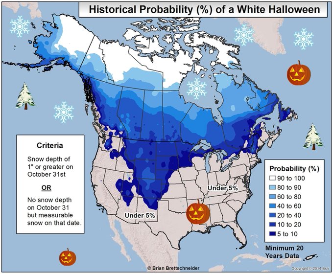
Alaska-based climatologist, Dr. Brian Brettschneider, plotted the chance of a "White Halloween" in any year in the U.S. and Canada.
Dreaming of a white Halloween? Climatology suggests that most of you should keep dreaming. (note: analysis uses 1st order stations)

As you can see, unless you're in the Rockies, High Plains, northern Plains, far northern Great Lakes or high country of northern New England, your chances are pretty slim.
MORE: Vintage Halloween Photos

Experts: More Significant Quakes Expected After Massive 6.6 Magnitude Tremblor Strikes Italy

October 31,2016
After central Italy was rocked by a 6.6 magnitude earthquake Sunday morning, experts say they can't exclude the possibility that there will be more, possibly stronger aftershocks in the area near Norcia .
British Geological Survey seismologist Margarita Segou told the Associated Press that the important thing to realize is that, while the number of temblors will decline over time, "we cannot  exclude the possibility of larger magnitude aftershocks.
Carlo Doglioni,  president of Italy's National Institute for Geophysics and Vulcanology, Carlo Doglioni, told The Associated Press that the intense activity along a series of faults in the region wasn't anomalous and ​that more significant quakes can be expected.
He said there was a similar sequence of three seismic events within a period of months in 1703, adding "it is normal for the Apennines," where there are a series of interdependent faults.
Doglioni said that natural law dictates that after such an event that there will be more quakes, "which means we can expect some 5 magnitude quakes and many of magnitude 4."
(MORE: Two Faults 'Holding Hands' Could Unleash Huge California Quake)
The USGS says the quake was centered about 4 miles north of Norica, Italy, and hit at 7:40 a.m. local time. Last Wednesday's 6.1 and 5.5 magnitude earthquakes were also centered in this same general area, along with many aftershocks in the following days.
There were no immediate reports of deaths, but about 20 people had suffered injuries as numerous buildings that had resisted the previous temblors collapsed.
Prime Minister Matteo Renzi said the nation's "soul is disturbed" by the series of quakes that began with the deadly Aug. 24 quake that killed almost 300 people.
He has vowed that the country will rebuild the homes, churches and other structures destroyed by the temblor, which is the latest to strike the region since Wednesday.
"We will rebuild everything - the houses, the churches, the shops," said Renzi. "We are dealing with marvelous territories, territories of beauty. These villages are the identity of Italy. We must reconstruct them all, quickly and well."
Residents already rattled by a constant trembling of the earth rushed into piazzas and streets after being roused from bed by the 7:40 a.m. quake.
Many people still had been sleeping in cars or evacuated to shelters or hotels in other areas after a pair of strong jolts on Wednesday. Curcio said 1,300 had been evacuated to the coast, and more would follow.
Rubble of a collapsed building in L'Aquila, central Italy, after an earthquake with a preliminary magnitude of 6.6 struck central Italy, Sunday, Oct. 30, 2016. A powerful earthquake rocked the same area of central and southern Italy hit by quake in August and a pair of aftershocks last week, sending already quake-damaged buildings crumbling after a week of temblors that have left thousands homeless. (Alberto Orsini/ANSA via AP)


The quake struck a cluster of mountain towns, many of historic significance, already reeling from last week's pair of aftershocks to an August earthquake that killed nearly 300: Norcia, Visso, Castelsantangelo sul Nero and Preci.
The head of the civil protection authority in Italy's Marche region, Cesare Spuri, said there were reports of buildings collapsing in many cities.
"We are trying to understand if people are under the rubble," Spuri said.
In the ancient city of Norcia, famed for its Benedictine monastery and its cured meats, witnesses said the 14th century St. Benedict cathedral crumbled, leaving only its facade standing.
Television images in the minutes after the quake showed nuns rushing out of their church and into Norcia's main piazza as the clock tower appeared ready to fall. One nun had to be carried by firefighters, while another was supported as she walked. Later, priests and nuns prayed in the square amid the rubble.
"It's as if the whole city fell down," Norcia city assessor Giuseppina Perla told the ANSA news agency.
The town closest to the quake's epicenter, Norcia is the birthplace of St. Benedict, the father of monasticism and has suffered a series of earthquakes over its history. The cathedral was built over Benedict's birthplace.
The monks of Norcia confirmed the collapse of the St. Benedict cathedral in a letter launching an immediate fundraising campaign to rebuild.
The current superior, who signed the letter to supporters as the Rev. Benedict, reported the cathedral was "flattened," and that monks were combing the city to help where needed.
"May this image serve to illustrate the power of this earthquake, and the urgency we monks feel to seek out those who need the sacraments on this difficult day for Italy," he wrote.
The deputy mayor of Norcia, Pierluigi Altavilla, said his house remained standing, but everything inside had been toppled.
"It seemed like a bomb exploded inside the house," he told Sky TG24.
The hilltop town of Camerino, some 60 kilometers from Ancona, suffered new building collapses but no reports of injuries. City spokesman Emmanuele Pironi said the main fire hall had been rendered uninhabitable and that they had transferred to a warehouse.
"An hour and a half after the quake, we can be reassured," Pironi told The Associated Press.
Pironi said most of the area's 9,000 university students had left after the town's historic center was closed due to danger of collapses last week, and some of the 7,000 residents had been moved to hotels near the coast or to shelters nearby. Few remained in their homes.
The mayor of quake-hit Ussita said a huge cloud of smoke erupted from the crumbled buildings.
"It's a disaster, a disaster!" Mayor Marco Rinaldi told ANSA. "I was sleeping in the car and I saw hell."
In Arquata del Tronto, which had been devastated by the Aug. 24 earthquake that killed nearly 300 people, Arquata Mayor Aleandro Petrucci said, "There are no towns left."
"Everything came down," he said.
New collapses also were reported in Tolentino, where the news agency ANSA said three people were extracted from the rubble.
The quake was felt throughout the Italian peninsula, with reports as far north as Bolzano near the Austrian border and as far south as Bari in the Puglia region. Residents rushed into the streets in Rome, where ancient palazzi shook, swayed and lurched for a prolonged spell.
Austria's governmental earthquake monitoring organization said the quake was felt to varying degrees in the east and south of the country and all the way to the city of Salzburg. It says that at its strongest, residents in upper floors noticed a swaying sensation and a slow swinging of hanging objects.
The quake sent boulders raining onto state highways and smaller roads, forcing closures throughout the quake zone that was impeding access to hard-hit cities such as Norcia. Traffic was being diverted to other roads.
The Salaria highway, one of the main highways in the region, was closed at certain points as it was after Wednesday's quakes.
In addition, Italy's rail line said some local lines in Umbria and Le Marche were closed as a precaution.
The European-Mediterranean Seismological Center put the magnitude at 6.6 or 6.5 with an epicenter 132 kilometers northeast of Rome and 67 kilometers east of Perugia, near the epicenter of last week's temblors. The U.S. Geological Survey put the magnitude at 6.6.
The German Research Centre for Geosciences put the magnitude at 6.5 and said it had a depth of 10 kilometers, a relatively shallow quake near the surface but in the norm for the quake-prone Apennine Mountain region.

Fall Heat Wave Will Smash Records From Halloween Into the First Days of November

Chris Dolce
Published: October 31,2016

Record warmth will continue to give a summer feel into the first days of November this week, with hundreds of daily record highs and warm lows likely to be set and also some monthly record highs expected in parts of the heat-weary South and Plains states.
Numerous daily record highs were broken Sunday. Atlanta's record high of 86 degrees was the latest 86-degree day on record there, surpassing the previous date of Oct. 28, 1940.
Meridian, Mississippi, hit 90 degrees Sunday, the latest such reading on record, there, beating the previous record by a full week (Oct. 23, 1941), not to mention adding to a new yearly record of 90-degree-plus days, there.
Other daily records were tied or set Sunday in Birmingham, Alabama (87 degrees), Knoxville, Tennessee (83 degrees), New Orleans (87 degrees), Austin, Texas (88 degrees), Washington D.C.'s Dulles Airport (84 degrees), Harrisburg, Pennsylvania (81 degrees), and Atlantic City, New Jersey (80 degrees).

Current Temperatures
Some southern cities could set a new daily record high each day through much of this week.
This continues what has been a much warmer-than-average month for the vast majority of Americans east of the Rockies, including a mid-October warm spell that shattered records.
Below are details on the forecast temperatures through Wednesday, along with perspective on how warm it has been so far this month.
(MORE: U.S. Warm Records Trouncing Cold Records)

Monday's Forecast (Halloween)


Forecast Highs Compared to Average Monday
  • Highs 10 to 25 degrees above average will surge back into the Upper Midwest, while continuing to encompass much of the Plains and South.
  • 70s are possible as far north as South Dakota, Illinois and Iowa.
  • 80s will once again rule the central Plains and South.
  • A few 90s are possible in the central and southern Plains, as well as the Deep South.
  • Record highs will likely be numerous from the central Plains into the Southeast, making it the warmest Halloween on record in some locations.
  • Potential daily record highs (record to beat is shown): Atlanta (85 degrees); Little Rock, Arkansas (86 degrees); Midland, Texas (85 degrees)
(MORE: Halloween Forecast)

Tuesday's Forecast


Forecast Highs Compared to Average Tuesday
  • Highs 10 to 25 degrees above average will surge back into the Great Lakes, Ohio Valley and Appalachians, while continuing to encompass much of the Plains and South.
  • 70s are possible as far north as Lower Michigan and western Pennsylvania.
  • 80s will once again rule the Ohio Valley, central and southern Plains and South.
  • A few 90s are possible in the Deep South.
  • Record highs will again likely be numerous from the Southeast to the Ohio Valley and in parts of the Plains, threatening some all-time November record highs in some areas.
  • Potential all-time November record highs (record to beat is shown): Amarillo, Texas (87 degrees); Cincinnati, Ohio (81 degrees); Louisville, Kentucky (84 degrees); Nashville, Tennessee (85 degrees)
(MORE: La Nina May Limit Drought Relief in the South This Winter)

Wednesday's Forecast

  • Highs more than 10 degrees above average will spread into parts of the Northeast, while also continuing in much of the Midwest and South. Portions of the Ohio Valley and southern Great Lakes will be more than 20 degrees above average.
  • 70s are expected in the southern Great Lakes, Ohio Valley and mid-Atlantic states.
  • 80s will dominate the Southeast, though it won't be quite as warm as previous days.
  • Daily record highs will be within reach in parts of the South and Ohio Valley.

Heat Wave Recap

Thursday, Phoenix smashed their record latest-in-season 100-degree high by four days.
Other record highs were tied or set Thursday in Denver (83 degrees), Salt Lake City (78 degrees) and Tucson, Arizona (97 degrees).
Friday, October 28, record highs were shattered in Garden City, Kansas (91 degrees - old record was 83), and Dodge City, Kansas (92 degrees - old record was 85) and new records were set in Amarillo, Texas (87 degrees), Pueblo, Colorado (87 degrees) and Meridian, Mississippi (89 degrees).
Friday was the fifth daily record high this month in Meridian, and was their hottest temperature so late in the season. Previously, the latest they reached 89 degrees was October 26, 2010. This is their average high on September 8.
Daily record high temperatures were toppled in many cities on Saturday. Among them were Huntsville, Alabama (88 degrees), and Amarillo, Texas (91 degrees), which both saw their warmest temperature so late in the calendar year.
Daily record highs were also set Saturday in Asheville, North Carolina (81 degrees), Blacksburg, Virginia (79 degrees), Nashville, Tennessee (86 degrees), Tupelo, Mississippi (89 degrees), St. Louis, Missouri (86 degrees), and Phoenix, Arizona (96 degrees).

How Warm It's Been

Many locations in the central and eastern United States have already experienced a very warm October.
This includes a large number of locations that will see warmer-than-average temperatures through Halloween. The only exception is the Northeast, where it will be near or even slightly below average through Halloween.
Temperatures compared to average Oct. 1-24, 2016. Areas shaded orange and brown have seen temperatures the farthest above average overall.
(Oregon State University Prism Climate Group)
Here are a few of the cities that were seeing a top five warmest October through Saturday, according to the Southeast Regional Climate Center.
Record warmest October-to-date:
  • Dallas
  • El Paso, Texas
  • Huntsville, Alabama
  • Lubbock, Texas
  • Midland, Texas
  • New Orleans
  • Tucson, Arizona
Second warmest October-to-date:
  • Albuquerque, New Mexico
  • Colorado Springs
  • Houston (Hobby Airport) 
According to NOAA's National Centers for Environmental Information, among reporting stations with at least a 30-year period of record, there have been roughly 11 daily record highs tied or broken for every record low so far in October.
Daily and Monthly U.S. Warm, Cold Records Tied or Broken in October 2016
Through Oct. 29 (Source: NOAA/NCEI)
 Daily RecordsMonthly Records
Warm5,487150
Cold5006

MORE: America's 50 Hottest Winter Cities

Weather Underground National Forecast for Monday,October 31,2016

By: nationalsummary , 10:00PM,GMT on October 30,2016


Weather Underground Forecast for Monday,October 31,2016

A low pressure area will shift across the northern Plains on Monday, while a Pacific system moves over the West Coast.

An area of low pressure will push east northeastward from the upper Intermountain West to south central Canada. This system will usher light to moderate rain across the northern Plains and the northern edge of the upper Midwest. A cold frontal boundary associated with this system will extend southwestward from the northern Plains to the Southwest. Light to moderate rain and high elevation snow showers will develop across the Wasatch and the Rockies. Gusty winds will also impact the region on Monday.

Another area of low pressure will move onshore over the Northwest. A cold frontal boundary associated with this system will generate periods of moderate to heavy rain and mountain snow across the Pacific Northwest, the northern Great Basin and northern California. Locally heavy precipitation will affect western facing slopes in northwest California, western Oregon and western Washington.

A dry weather pattern will persist across most states stretching from the southern Plains to the Southeast. Temperatures will be 10 to 20 degrees above normal in the central and the southern Plains.

A cold and dry air mass will spread across the Northeast on Monday. High temperatures will struggle to climb above the lower 50s in New England. Boston, Mass., will be sunny with a high of 51(F)/ 10(C). Portland, Maine, will be partly cloudy with a high of 52(F)/ 11(C).

This Date in Weather History for October 31,2016 from weatherforyou.com

Weather History
For Monday,October 31,2016


1846 - Eighty-seven pioneers were trapped by early snows in the Sierra Nevada Mountains that piled five feet deep, with 30 to 40 foot drifts. Just 47 persons survived the "Donner Pass Tragedy". (The Weather Channel)
1950 - Unseasonably warm weather prevailed in the central U.S. for Halloween. The temperature soared to 83 degrees at Minneapolis MN, their warmest reading of record for so late in the season. (The Weather Channel)
1965 - Fort Lauderdale, FL, was deluged with 13.81 inches of rain, which brought their rainfall total for the month of October to an all-time record of 42.43 inches. (30th-31st) (David Ludlum) (The Weather Channel)
1987 - Halloween was a wet one in the southwestern U.S. Heavy rain in southern California resulted in numerous mudslides. Weather-related auto accidents resulted in three deaths and twenty-five injuries. Mount Wilson CA received 3.14 inches of rain in 24 hours. Yakima WA reported measurable rainfall for the first time since the 18th of July. The 103 day long dry spell was their longest of record. (The National Weather Summary) (Storm Data)
1988 - Twenty-two cities in the northeastern U.S. reported record low temperatures for the date. The low of 19 degrees at Cleveland OH was a record for October, and morning lows of 21 degrees at Allentown PA and Bridgeport CT tied October records. Nine cities in the southwestern U.S. reported record high temperatures for the date, including Phoenix AZ with a reading of 96 degrees. Showers made Halloween a soggy one in the southeastern U.S. (The National Weather Summary)
1989 - Halloween night was a soggy one in New England. Showers in the northeastern U.S. produced more than an inch and a half of rain in six hours at some locations. An invasion of cold arctic air brought an abrupt end to a week of "Indian Summer" type weather in the Great Lakes Region, and brought snow and subzero wind chill readings to the Northern Plains. In Colorado, Alamosa was the cold spot in the nation with a record low of two degrees above zero, and a Halloween night storm brought 3 to 6 inches of snow to the Front Range, and 5 to 10 inches to the nearby foothills. Icy streets around Denver the next morning made for a rather spooky commute. (The National Weather Summary) (Storm Data)

Sunday, October 30, 2016

New York City metro-area forecast for October 30-November 13,2016 from weather.com

Here's the 15-day weather forecast for the New York City metro-area for the period of the last 2 days of October and the first 13 days of November (October 30-November 13),2016 from The Weather Channel's web-site;weather.com


Tonight,October 30-31: Remaining partly to mostly cloudy,but turning markedly colder as it turns seasonably chilly to cold for mid-autumn,with a late low temperature dropping to 40-45 degrees,overnight.As of 1:15AM,EDT,October 31,it's 52 degrees and mostly cloudy,with 84% humidity,in White Plains,NY,and it's 54 degrees and mostly cloudy,with 74% humidity,in New York City.

Tomorrow,October 31: Halloween 2016 will be turning sunny and markedly colder than recent days as it turns chilly,with a high temperature of just 50-55 degrees.

Tomorrow night,October 31-November 1: Becoming clear and cold with a low temperature dropping to the middle and upper 30's,overnight.

Tuesday,November 1: November of 2016 begins turning mostly sunny and milder,with a high temperature of 55-60 degrees.Becoming partly cloudy and warmer than recent nights,with a low temperature dropping to 45-50 degrees,overnight.

Wednesday,November 2: Turning unseasonably mild,once again,with a mix of sunshine and some clouds and a high temperature in the middle and upper 60's.Remaining unseasonably mild for the beginning of November,with a few clouds and a low temperature dropping to 50-55 degrees, overnight.

Thursday,November 3: Becoming partly cloudy through the morning,followed by increasing cloudiness and a chance for some afternoon rain and a high temperature of 65-70 degrees.Not as mild,with a few clouds and a low temperature dropping to the middle and upper 40's,overnight.

Friday,November 4: Turning sunny and markedly colder than recent days,as it turns chilly,once again, with a high temperature of just 50-55 degrees.Turning clear and much colder than recent nights,with a low temperature dropping to 35-40 degrees,overnight.

Saturday,November 5: Turning partly cloudy and seasonably cool for very early November,with a high temperature in the middle 50's.Remaining seasonably chilly to cold for mid-autumn,with a low temperature dropping to the upper 30's to lower 40's,overnight.

Sunday,November 6: Turning chilly,despite plentiful sunshine,with a high temperature only in the upper 40's to lower 50's.Remaining clear and seasonably cold for mid-autumn,with a low temperature dropping to 35-40 degrees,overnight.

Monday,November 7: Remaining mostly sunny and chilly for early November,with a high temperature only in the upper 40's to lower 50's,once again.Remaining clear and seasonably cold with a low temperature dropping to the middle and upper 30's,overnight.

Tuesday,November 8: Election Day 2016 will be remaining mostly sunny and seasonably cool for early November with a high temperature of 50-55 degrees.Becoming mostly cloudy through the evening followed by partly cloudy skies late,with a low temperature dropping to around 40 degrees,overnight.

Wednesday,November 9: Becoming partly cloudy,but remaining seasonably cool for early November,with a high temperature in the lower and middle 50's.Remaining partly cloudy and chilly to cold,but not too terribly so for early November,and mid-autumn,with a low temperature dropping to around 40 degrees,once again,overnight.

Thursday,November 10: Becoming mostly sunny,but remaining seasonably cool with a high temperature of 50-55 degrees.Remaining mostly clear and seasonably cold for mid-to-late autumn, with a low temperature dropping to 35-40 degrees,overnight.

Friday,November 11: Veteran's Day 2016 will be remaining mostly sunny and mild,with a high temperature of 50-55 degrees,once again.Turning partly cloudy in the evening followed by increasing cloudiness and occasional late-night rain possible and a low temperature dropping to the upper 30's to lower 40's,overnight.

Saturday,November 12: Turning cloudy and rainy,but remaining a bit mild for early-to-mid November and mid-to-late autumn,with considerable cloudiness and occasional rain possible and a high temperature,for the third straight day,of 50-55 degrees.Remaining cloudy and rainy with evening rain followed by intermittent late-night rain possible and a low temperature dropping to 35-40 degrees,overnight.

Sunday,November 13: Remaining cloudy and rainy with morning rain followed by intermittent afternoon rain possible and a high temperature only in the upper 40's to lower 50's.Becoming partly cloudy in the evening followed by increasing cloudiness and a chance for a few late-night rain showers and a low temperature dropping to 35-40 degrees,once again,overnight.

National Temperature and Rainfall Extremes for October 30,2016 from accuweather.com

As of 11PM,EDT/8PM,PDT


Daily U.S. Extremes

past 24 hours

  Extreme Location
High 97° Gila Bend, AZ
Low 15° Angel Fire, NM
Precip 1.38" Erie, PA

Relentless heat, dryness to aggravate Southeast drought

By Brian Thompson, Meteorologist
October 30,2016; 9:55PM,EDT
 
 
No rain is in sight for most of the Southeast through the opening days of November, thanks to a persistent warm and dry pattern.
The ongoing stretch of warmth and dryness in the region will spell bad news for the worsening drought.
Cities such as Pensacola, Florida, as well as Birmingham and Mobile, Alabama, are likely to end up with no measurable precipitation during the month of October.
The dry weather has been accompanied by record-breaking warmth, which will continue for much of this week.
Atlanta will likely set a new record for the warmest September through the October period, on the heels of the city's second warmest summer.

"The abnormal warmth contributes to more moisture evaporating out of the soil. When the moisture does not get replenished, it's like a vicious cycle," AccuWeather Meteorologist Mike Doll said.
Birmingham, Alabama, has not received measurable rainfall since Sept. 18.
The city will only have received 0.68 of an inch of rain for the months of September and October, combined. That is just 9 percent of what Birmingham typically receives over the two-month span.

According to the U.S. Drought Monitor, over 73 percent of Alabama is experiencing severe to exceptional drought conditions.
Mississippi has not fared much better. Both Jackson and Tupelo have recorded just 12 percent of what each city receives in September and October.
Drought areas across the state are affecting over 2.9 million people, U.S. Drought Monitor data reveals.
RELATED:
US winter forecast: Freeze may damage citrus crop in South
5 weather threats to be wary of during the fall
Halloween forecast: Chilly air to make a comeback in northeastern US in time for trick-or-treating

This persistent dry weather is not predicted to end anytime soon.
"Unfortunately, the jet stream pattern this week will continue to guide storm systems and moisture north of the Southeast region," Doll said.
With rainfall deficits growing deeper, several storm systems producing heavy rain will be necessary to put a significant dent in the building drought.
According to Doll, a pattern like this is not expected to materialize over the next couple of weeks.

November marks final month of 2016 Atlantic hurricane season; will more storms brew?

By Jordan Root, Meteorologist
October 30,2016; 9:05PM,EDT
 
 
As the calendar flips over to November, the 2016 Atlantic hurricane season will enter its final month. The big question is, will there be anymore brewing storms across the basin?
Up to this point, the season has been rather active. A total of 14 named-storms have formed, putting this season above the average of 12. Of those 12, six went on to become hurricanes, three of them reaching major hurricane status. Both of those numbers are typical for the season.
While the Atlantic hurricane season officially runs from June 1 to November 30, the season on average features the most activity between late August and the end of September and declines afterwards.
"As we head into November, historically the likelihood of tropical cyclone formation drops significantly," AccuWeather Meteorologist Ed Vallee said.

The tropics have indeed turned quiet as of late. The last system to form was Hurricane Nicole back on October 4.
There are several reasons for a decline in tropical activity late in the season.
"Lowering water temperatures and significantly higher wind shear across the Atlantic are two major factors for a decrease in development in November," Vallee said.
Wind shear refers to the changing speed and direction of the wind with height. Strong winds aloft can disrupt and prevent storms from organizing.
The jet stream, a river of fast moving air high in the atmosphere, begins to descend farther south during the autumn months and leads to increased wind shear across portions of the Atlantic basin, especially the Gulf of Mexico and East Coast.
This tends to push the development zone farther south and east away from the United States.

"The most common areas of development are in the Caribbean and out in the central Atlantic," Vallee said.
These areas, and the rest of the Atlantic basin, are quiet as of now and will likely remain that way through at least next week.
"There are no tropical systems at this time but there are a few features we are watching," AccuWeather Meteorologist Mike Doll said.
One of these features is an area of low pressure north of Puerto Rico. It will remain nearly-stationary early this week before it tracks northeastward away from land.
"The chance of this feature becoming a tropical system is very low," Doll said.

The other feature, another area of low pressure, is southwest of Grand Cayman Island and is very disorganized. It will likely not pose any threat for further development.
Wind shear is expected to remain high this week across the typical breeding grounds which will hinder any possible development with passing tropical waves. This will likely remain a common issue through the rest of the month.
RELATED:
AccuWeather Hurricane Center
Hurricane Matthew uncovers Civil War-era cannonballs in Folly Beach, South Carolina
WATCH: Aerial footage shows extreme erosion of Florida Beach

However, the disruptive shear can relax for a short amount of time and if that does occur, a system could quickly develop.
"Water temperatures are above normal in the Caribbean and Atlantic, so the threat for some formation remains possible through the end of the hurricane season," Vallee said.
If a feature can organize and become a named storm, the next name on the list is Otto.
A strong tropical system this November would not be unprecedented. Hurricane Kate in 1985 and Hurricane Lenny in 1999 are two examples of late-season hurricanes that formed during the middle of November. Both systems reached major hurricane status.

Halloween forecast: Chilly air to make a comeback in northeastern US in time for trick-or-treating

By Renee Duff, AccuWeather.com Meteorologist
October 30,2016; 8:25PM,EDT
 
 
Dry and mild weather will dominate a large part of the United States as trick-or-treaters head out the door on Monday evening, Oct. 31.
Rain jackets and winter coats can be left behind across most of the central and eastern U.S., but rain could put a damper on Halloween festivities across parts of the Upper Midwest and West Coast.
Before heading outside on Monday evening, check AccuWeather MinuteCast® to know exactly when rain will fall.

Showers could dampen Halloween plans across Upper Midwest, West Coast
Trick-or-treaters across a portion of the West and Upper Midwest will need to think twice before leaving the house without rain gear on Halloween.
Trick-or-treaters may need some rain protection for their costumes across North Dakota, Minnesota and Upper Michigan, as well as along the West Coast from Seattle to San Francisco.
"The steadiest rain is likely to fall in northeastern North Dakota and northern California," AccuWeather Senior Meteorologist Kristina Pydynowski said.
Most of the rain, otherwise, will be hit-or-miss in nature, with some areas getting missed completely by any wet weather. However, there could even be isolated thunder and lightning in western Upper Michigan and neighboring northern Wisconsin to add to the spooky nature of the evening.
RELATED:
Top weather phobias explored: Millions of Americans experience these weather fears
5 weather threats to be wary of during the fall
Interactive weather radar

Those who do not wish to cover up their costumes with a rain jacket while trick-or-treating should consider bringing along an umbrella or poncho to dodge any rain.
Despite the potential for wet weather, there will not be a need for extra layers under costumes as temperatures will be about 10 degrees above normal across the Midwest.
Temperatures will be closer to seasonable levels along the West Coast.
Dry, mild weather to dominate central, southern US
A dry and mild Halloween is in store for many across the central and southern states.
"Much of the central U.S. through the Southeast looks dry and unseasonably warm for trick-or-treating activities," AccuWeather Meteorologist Ryan Adamson said.
Extra layers and winter coats can be left behind even as the sun dips below the horizon.
(Thinkstock/Zoonar/Zoonar RF)
After record highs are set during the day, temperatures will generally be in the 70s across the South and South Central states. Early-evening temperatures in the 60s are expected across the Upper Midwest.
Only very spotty showers and rumble of thunder may linger from the afternoon into the evening along the southern Texas coast as winds blow off the Gulf of Mexico.
Chill to return to Northeast in time for Halloween
After a warmup over the weekend, cooler air will return to the Northeast in time for Halloween.
"Temperatures will be in the 30s in the interior of northern England and upstate New York and the 40s in southern and eastern New England by the time trick-or-treaters head out the door," Pydynowski said.
Across the mid-Atlantic, temperatures will range from the 40s across the north to the 50s in the south.
Jackets or extra layers may be needed for those sensitive to the cool conditions, but rain gear can be left at home as dry conditions will prevail across the region.

Dig out the coats: November to be 'significantly colder than last year' in northeastern US

By , AccuWeather.com Senior Meteorologist
October 30,2016; 8:36PM,EDT
 
 
Winter will continue to get a grip on the weather in the northeastern United States during November as waves of colder air roll in with occasional storms.
In the short term, warmth that has persisted over much of the Central states during October will bulge into the mid-Atlantic into this week. However, waves of chilly air will limit the warmups over upstate New York and New England.
The waves of chilly air will become more aggressive with weaker warmups in between the cold blasts from mid-November into December, according to AccuWeather Lead Long-Range Meteorologist Paul Pastelok.

"In most areas of the Northeast, this November will likely be perceived as being rather cold," Pastelok said. "We expect this November, and this winter for that matter, to be significantly colder than last year, but temperatures are likely to average near normal."
Temperatures averaged 6-10 degrees above normal during the period from November through December in 2015.
Normal temperatures trend downward significantly during November and into December.
At the start of November, normal high temperatures range from middle 60s in southeastern Virginia to the middle 40s in northern Maine. By the first week in December, normal high temperatures range from the middle 50s in southeastern Virginia to the lower 30s in northern Maine.
"Additional storms similar to the ones that brought snow this past week can repeat during the late fall and early part of the winter," Pastelok said.
RELATED:
US winter forecast: Frequent snow to blast Northeast
5 weather threats to be wary of during the fall
Check AccuWeather MinuteCast® for your location

The latter part of October delivered two storms with doses of cold rain and accumulating wet snow across some of the higher elevations and the normally colder northern areas.
The anticipated pattern from mid-November and lasting into December will be due to a strong jet stream over the northern tier of the nation. The jet stream, which is a fast river of air high in the atmosphere, also represents the boundary between cold air to its north and warm air to its south.
While cold and snow can sweep toward part of the New England coast and the central Appalachians, snow will not be in a hurry to sweep toward the mid-Atlantic Interstate 95 corridor into early December.
The anticipated cold waves should lead to lake-effect snow in portions of western and upstate New York, western Pennsylvania and northeastern Ohio.

Warm Great Lakes waters will initially cause a rain and snow mix immediately downwind of the lakes. As the air gets colder into December, accumulating snow will expand toward the lakeshore areas and into lower elevations.
Motorists can beat the rush just ahead of the first big snowstorm of the season by preparing their vehicle for winter now.
Make sure windshield wipers are in good condition, the antifreeze can handle the frigid mornings and there is significant tread on the tires. While winter (snow) tires are the best option, a fresh set of all-weather tires with an aggressive tread and sufficient thickness can get most drivers through the bulk of winter road conditions.

Strongest earthquake in over 3 decades strikes Italy

By Brian Thompson, Meteorologist
October 30,2016; 8:30PM,EDT
 
The strongest earthquake to hit Italy since 1980 struck on Sunday morning, damaging numerous buildings and injuring many.
The U.S. Geological Survey assigned the quake a preliminary magnitude of 6.6, with a depth of 10 km.
The earthquake occurred at 7:40 a.m. on Sunday, local time, and was centered 132 km (82 miles) northeast of Rome, near the town of Norcia.

According to the Associated Press, buildings collapsed in some of the hardest-hit areas. One building that sustained major damage was the 14th century St. Benedict cathedral. Several people were also injured, though there were no immediate reports of fatalities.
Several aftershocks have been reported since the initial quake with at least six having a magnitude of at least 4.0.
This area was hit by a 6.2-magnitude quake in August, which caused major damage and killed 290 people.
More recently, a magnitude 6.1 earthquake struck central Italy on Oct. 26.
Sunday's earthquake is the strongest one on record to strike Italy since the Irpinia earthquake in 1980. That earthquake measured a magnitude of 6.9 in 1980 and struck the southern portion of the country, killing over two thousand people.
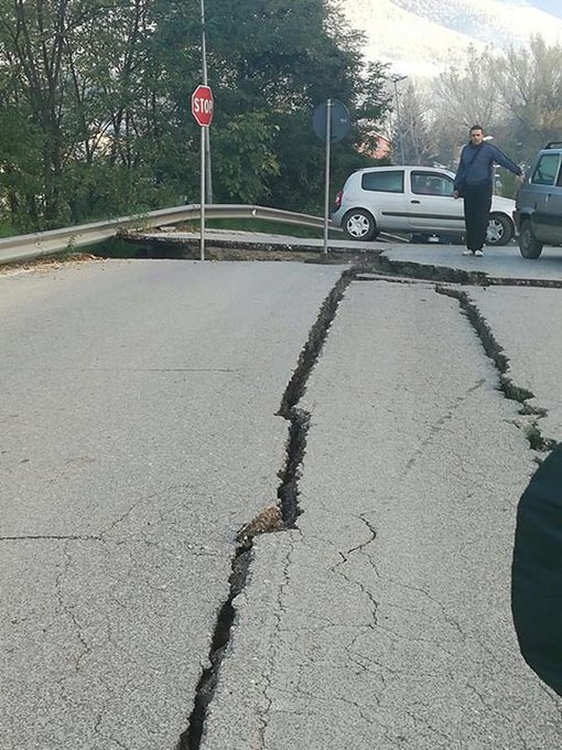
la strada che porta a Norcia

A road leading to Norcia is badly damaged from the earthquake. Twitter/@FrankPetrucci
Weather conditions through early this week should not hinder emergency operations or cleanup.
"The weather will be mainly dry across Italy early this week as high pressure settles in," AccuWeather Meteorologist Brett Rossio said. "However, a cold front may bring a few showers at midweek."
AccuWeather Meteorologist Jordan Root also contributed to this story.


Storm train to persist across western US into early week

By Renee Duff, AccuWeather.com Meteorologist
October 30,2016; 8:22PM,EDT
 
A pair of storms with rain, wind and mountain snow will impact the West Coast of the United States into early this week.
The bulk of the rain is expected to focus on northern California northward to Washington and eastward to Idaho and Montana into Monday.
Lighter showers will dampen Southern California, mainly from Los Angeles northward.
The first storm will spread rain, mountain snow and gusty winds across the West Coast into Monday morning.

The heaviest rain associated with the storm will focus on northwestern California and the western slopes of the northern Sierra.
"Upwards of 2 to 3 inches of rain is expected across northern California with this storm," according to AccuWeather Meteorologist Kyle Elliott.
A few showers could reach as far south as Los Angeles, but rainfall totals will likely stay under 0.10 of an inch outside of the southwestern slopes of the mountains.
Batches of showers and heavier downpours are expected to expand north and east from Sunday into Monday, reaching areas from Seattle to Billings, Montana.
Flooding will mostly be localized, but any areas under the most persistent downpours may experience minor street and stream flooding.
The greatest threat for mudslides will exist in recent burn areas.
A gusty breeze will pick up as the storm moves through, with most areas experiencing wind gusts between 20 and 30 mph. The highest winds will likely target Nevada, where gusts between 40 and 50 mph are predicted.
RELATED:
US winter forecast: Early storms to blast Northwest, northern California
WATCH: Stunning fall foliage compilation
Check AccuWeather MinuteCast® for your location

The strongest winds can lead to very sporadic power outages and minor tree damage, given the saturated nature of the soil from rainfall this past week.
In addition to the wet weather, there will also be a wintry side to the storm as feet of snow target the Sierra Nevada and Teton Mountains.
"Snow levels will drop down to Interstate 80 at Donner Pass, California, during Sunday and Sunday night," according to AccuWeather Senior Meteorologist Alex Sosnowski.
Snowfall could reach 2 feet in the Sierra Nevada, creating dangerous travel conditions for anyone without tire chains.
Strong wind gusts will also howl, making travel nearly impossible for a time. Officials may be forced to close roads for a time.
The heaviest snow, in excess of 6 inches, will fall above 7,000 feet, but snow can lightly coat grassy and elevated surfaces down to 5,500 feet later on Sunday.
"Skiers will certainly be happy with the snow," Elliott said.
As quickly as the first storm exits the region, a second, much weaker storm will push inland with some rain across northern California from late on Monday into Tuesday.
During the middle to latter part of the new week, the storm track will shift farther north and aim for the Pacific Northwest and coast of British Columbia.

"Toward midweek, a vigorous storm will pound British Columbia and northern and western Washington with rain and gusty winds," Elliott said.
Accuweather meteorologists expect this stormy pattern to persist across the Northwest and northern California into the start of winter.
 

Storms to bring gusty winds to Northeast Sunday

By Jordan Root, Meteorologist
October 30,2016; 6:06PM,EDT
 
 
A round of strong storms will threaten a portion of the Northeast later on Sunday, putting millions of people at risk.
An unseasonably warm air mass and a sufficient amount of moisture will cause the atmosphere to turn unstable during Sunday afternoon and evening across Ohio, Pennsylvania, southern New York, New Jersey and Maryland. An approaching cold front will cause a few thunderstorms to ignite, some of which may turn strong.

"Some of the storms will be capable of producing a few wind gusts to 60 mph," AccuWeather Storm Warning Meteorologist Alex Avalos said.
Wind gusts of this magnitude could bring down small trees, cause power outages and blow around any loose objects outside.
A few places that could have heavy and gusty thunderstorms include New York City, Trenton, New Jersey, Philadelphia, Harrisburg, Pittsburgh and Allentown, Pennsylvania.
Travel on interstates 76, 79, 80, 81, and 95 could be impacted for a time by passing showers and thunderstorms.
The storms will bring downpours that will lower visibility and slow travel. Motorists will want to use caution if they encounter a brief period of heavy rain. Outdoor plans will likely be delayed or even ruined later on Sunday.
RELATED:
Northeast Weather Radar
5 weather threats to be wary of during the fall
AccuWeather Severe Weather Center

"The storms will also be capable of producing a few instances of large hail," Avalos warned.
Folks will want to keep an eye to the sky and to weather radar this afternoon and evening.
Any strong thunderstorms that do develop are expected to weaken late this evening once the sun sets.
Despite November being just a couple days away, thunderstorms this time of the year in the Northeast still can pack a punch under the right conditions. Clashes of warm and cold air can stir up the atmosphere just enough for strong thunderstorms to form during mid- to late autumn.