Published: May 4,2015
However, breezy conditions and low humidity accompanying the warmth in the Northeast Monday are resulting in a high potential for wildfires to spread, should any ignite.
(INTERACTIVE MAP: Red Flag Warnings)

Current Temperatures
Let's list some recent cold factoids to shed insight on how excited those in the Northeast and Midwest are to see this warmth stick around:
- Buffalo, New York: Flakes of snow fell three straight days from April 22-24. Highs in the 40s or colder all but two days from April 22-27.
- Marquette, Michigan: High of 26 degrees on April 22 was their coldest high so late in the season, dating to 1961.
- Bessemer, Michigan: One foot of snow April 22-23.
- Pittsburgh, Pennsylvania: A dusting of snow on the morning of April 25.
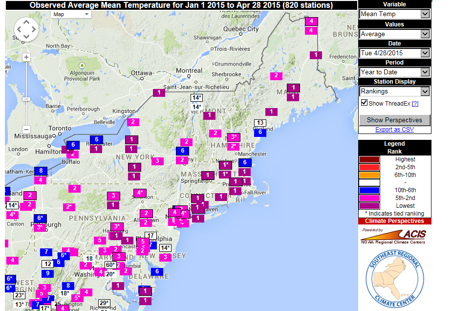
And just to hammer home the point, many cities in the Northeast have shivered through their coldest year-to-date on record, as illustrated by all the "1s" plotted on the map below from the Southeast Regional Climate Center.
Year to date a very cold start across the northeast U.S. #mewx http://www.sercc.com/perspectivesmap?region=conus …
Flatter Jet = Higher Temps

Midwest Forecast

Northeast Forecast
The warm-up is already underway in parts of the Northeast and Great Lakes, and it will stick around for much of the week ahead.
(INTERACTIVE: Your Current Temperatures)
Instead of taking a sharp southward dip in the eastern U.S., the polar jet stream has flattened out, tracking more west-to-east across the northern Great Lakes, eastern Canada and northern New England.
Following a nice weekend, a cold front and its attendant thunderstorms will take the top off temperatures in the Great Lakes through Tuesday. However, temperatures are forecast to rebound quickly. For example, Chicago could see multiple days with highs in the low 80s later this week. The last time the Windy City recorded a high in the 80s was on Sept. 29, 2014.
(FORECAST: Chicago | Cleveland)
Elsewhere, highs in the 80s will also be a common sight in the Ohio Valley and middle Mississippi Valley this week, including Cincinnati and St. Louis.
In the Northeast, Monday's high of 85 degrees in New York City was the warmest temperature there since Sept. 6, 2014 when it hit 91 degrees. The rest of this week the Big Apple will see highs mostly in the 70s.
Boston topped out in the 80s on Monday, making it the first time in more than six months that its been above 80 degrees in the city. The last time Logan International Airport made it into the 80s prior to Monday was on Oct. 15. The rest of this week highs in the 70s are expected.
Farther south, highs in the 80s will be common in the Mid-Atlantic throughout the week, including Philadelphia and Washington, D.C. The exception for Philadelphia will be Wednesday when a brief cooldown arrives in the Northeast.
(MAPS: 10-day forecast highs)
(NOAA/NCDC)
(MAPS: 10-day forecast lows)
Of course, this doesn't rule out another stubbornly cold period later in May. However, at least for the first week or so of the month, it appears the cold-weary Great Lakes and Northeast can enjoy spring's warm embrace.
(MORE: May Outlook)
We'll leave you with one final factoid that should warm your heart.
A cooperative observer near Eastport, Maine, finally reported all the snow has melted as of Monday. On February 17, that same observer reported 78.5 inches of snow - over 6.5 feet - on the ground. For the season, Eastport measured 183.2 inches - over 15 feet - of snow.
Now it's gone. Goodbye, winter 2014-2015.
Meteorologist Chris Dolce contributed to this report.


No comments:
Post a Comment