February 15,2014
Pax also brought heavy snow to Appalachians, Middle Atlantic and Northeast late Feb. 12 into Feb. 14.
Below are some notable snow, sleet, and ice reports reports from Winter Storm Pax by state. Northeast states are listed first followed by a recap of the South.
Northeast Reports
")
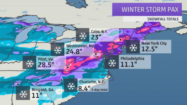
Pax Snowfall Totals
Winter Storm Pax snowfall totals. (Note: snowfall contoured in the western Great Lakes and Ohio Valley was not from Pax.)Rhode Island
- 10.1" in West Glocester
- 2.2" in Providence
Vermont
- 30" in Mount Holly
- 24" in Shrewsbury
- 12" in East Montpelier
- 8.9" in Burlington
New Hampshire
- 19.4" near Sunapee
- 12" in Peterborough
- 10.7" in Keene
- 9.9" in Concord
- 8" near Manchester
Maine
- 17" near Linneus
- 14" in Greenwood, Mount Vernon
- 9.9" in Caribou
- 9.4" in Portland
- 6.5" in Bangor
Massachusetts
- 21" in Beckett
- 16" in Lanesborough, Ludlow
- 13.6" in Southwick
- 13.1" in Worcester
- 12.5" in Savoy, West Springfield
- 3.3" at Boston Logan Airport
Connecticut
- 16.8" in Darien
- 16.2" in Fairfield
- 13.5" in Milford
- 12.2" in Bridgeport
- 9" in Danbury
- 8.6" in Windsor Locks
Delaware
- 14.4" in Greenville
- 14.1" in Newark
- 12.5" in Wilmington
- 7.4" in Dover
Maryland
- 26" in Glyndon
- 24.8" near Westminister
- 24" in Owings Mills, Reisterstown
- 23" in Oakland
- 22" in Redhouse
- 20.5" near Frederick
- 19" near Damascus
- 11.5" at Baltimore-Washington International Airport (BWI)
New Jersey
- 19.2" in Highland Lakes
- 14.4" in East Rutherford
- 11.9" in Newark
- 11.5" in Camden
- 5" in Trenton
- 3" in Atlantic City
New York
- 27" in South Berne
- 25.8" in Jewett
- 21" in Poughkeepsie
- 14.4" in Albany
- 12.5" in New York City (Central Park) - Snow rates 3"+ per hour observed Feb. 13.
- 9.5" in Syracuse
- 6.1" in Binghamton
Pennsylvania
- 24" in Millers
- 20" in Dover
- 18.8" in Allentown - 17.9" Feb. 13 was third snowiest day on record
- 11.1" at Philadelphia International Airport
- 10" in Scranton/Wilkes-Barre
- 9.5" in Harrisburg
- 6.7" in Williamsport
Virginia
- 28.5" near Pilot
- 26.3" in Alum Ridge
- 23" near Copper Hill
- 20.1" in Blacksburg (NWS office) - Third heaviest snowstorm on record
- 19" in Roanoke - Third heaviest snowstorm on record
- 18" in Winchester
- 13.3" at Dulles International Airport
- 7" at Washington National Airport
West Virginia
- 27.5" in Mount Storm
- 25" near Cherry Grove
- 21" in Harman
- 20" in Montrose
- 17" in Beckley
- 14.9" in Bluefield
South Reports
Alabama
Snow:- up to 10" in Cullman
- 9" in Eva
- 5.5" in Grant and Rainsville
- Up to 5.0" in Cullman
- 3.9" in Huntsville
- 1.3" in Huntsville
- 0.70" near Bessemer
- 0.5" near Heflin
- 0.25" in Center Point)
- 0.25" in Tarrant
Arkansas
Freezing Rain/Ice:- 0.25" in Bradley
- 2" snow/sleet in Lake Village
Georgia

Georgia Ice Totals
Credit: National Weather Service Atlanta, Ga.- 11" in Ringgold
- 8.5" in Cornelia
- 7" in Elberton
- 5" in Cartersville
- 4.5" Sugar Hill
- 5" in Summerville
- 4" in Blue Ridge
- 0.75" to 1" in Augusta - multiple trees, power lines downed
- 0.75" near Millen in southeast Georgia
- 0.38" ice in Peachtree City, Forsyth
- Up to 0.25" in Fayetteville, Snellville
Louisiana
The biggest impacts were with the second round of Pax.Sleet:
- 1" in Farmerville
- 1" in Tallulah - accumulating on trees and powerlines
- 0.5" in Harrisonburg - ice accumulating on trees and powerlines; several accidents and power outages reported
- 0.3" in West Monroe
- 0.25" in Homer
- 0.25" in Shreveport - the National Weather Service Forecast Office lost power and had to transition to using a back up generator
- 0.23" in Alexandria - the airport sensor lost power and may have underestimated the ice
Kentucky
- 14" in Jenkins
- 12" in Mouthcard
- 12" in Dorton
Mississippi
The highest snowfall totals were with the first part of Pax Feb. 10 to Feb. 11. Freezing rain was more of a problem late Feb. 11 into Feb. 12.Snow:
- 3.5" near Corinth
- 1.5" in Oxford
- 0.1" in Amory and Merigold
- Up to 1" of ice accumulation in Alcorn on elevated surfaces
- At least 0.25" in Yazoo City
- 0.25" near Natchez with some trees down
- 0.25" in Kosciusko
- 0.2" in Vicksburg - some icing on bridges and roadways
- 0.1" in Starkville
North Carolina
Snow:- 21" in Boones Hill
- 19" in Boonville
- 17" in Mount Airy
- 8.4" in Charlotte (3-day Total)
- Up to 6" south of Raleigh, 3.7" at Raleigh-Durham Airport
- 10" in Pollocksville, Bayboro New Bern
- 9" in Oriental and James City
- 8" in Bridgeton, Trenton, and Engelhard
- 7.3" in Asheville
- 6" in Pink Hill, Maysville, Wallace, and near New Bern
- 0.56" in Wilmington; over 56,000 customers without power at one time in the area
- 0.3" in Bettie - thick coating of ice on tree limbs and powerlines; branches coming down with some power outages reported
- 0.25" in Durham
Oklahoma
Snow:- 6.5" in Alva
- 3.2" in Enid
South Carolina

- 10" in Clover
- 7.3" near Carlisle
- 6.5" in Rock Hill
- 6.3" at Greenville-Spartanburg Int'l Airport (3-day total)
- 2.1" in Columbia - First time with 3 straight days of snow since Jan. 1940.
- 4" in Irmo
- 2" in Bishopville and Aiken
- 1" in Sumter and Orangeburg
- Up to 1.25" ice in Barnwell with widespread trees and power lines down.
- Up to 1.20" ice in Aiken with widespread trees and power lines down.
- Up to 1" ice in Bamberg, Manning, Orangeburg, Saint Matthews with widespread trees and power lines down.
- Icing reported as far south as the Charleston area.
Tennessee
Snow Wednesday:- 11.5" near Jonesborough
- 8" in Sneedville
- 7.2" in Chattanooga
- 7" in Oak Ridge
- 5.9" in Knoxville - First 5"+ snow event since Jan. 17, 1996
- 0.1" near Etowah and Pikeville
- Multiple accidents in Memphis on the morning of Feb. 12 due to freezing drizzle
Texas
Snow:- 4.3" near Borger
- 1.5" near Amarillo
- 0.25" near Bullard
- 0.02" in Dallas

Residents dig out from a snow storm in Richmond, Va., Thursday, Feb. 13, 2014. (AP Photo/Steve Helber)
No comments:
Post a Comment