Super Typhoon Nepartak is crossing through southern Taiwan with violent winds and drenching rains. Nepartak is forecast to weaken later today as it interacts with the mountains of Taiwan.
Wind gusts up to 125 mph have battered the southeastern coast of Taiwan and nearly a foot of rain has fallen across southern part of that country.
(MORE: Taiwan Prepares For Direct Hit)

Latest on Nepartak
Radar from Taiwan's Central Weather Bureau (CWB) indicates bands of heavy rain are now lashing Taiwan. Rain rates from 1 to 3 inches per hour were measured in parts of central and southern Taiwan, according to the CWB.
As of Friday morning (Taiwan time), the east coast of Taiwan has seen 6-12 inches of rainfall.
Some wind gusts from 80-100 mph battered the east coast of Taiwan, including Feng Nin. At 5 a.m. (Taiwan time) Taitung recorded a wind gust of 125 mph. Higher wind gusts have likely been measured over higher elevations including on the smaller island of Lanyu, where gusts climbed to 160 mph at an elevation over 1,000 feet in the outer eyewall.

Current Wind Gusts, Enhanced Satellite Image
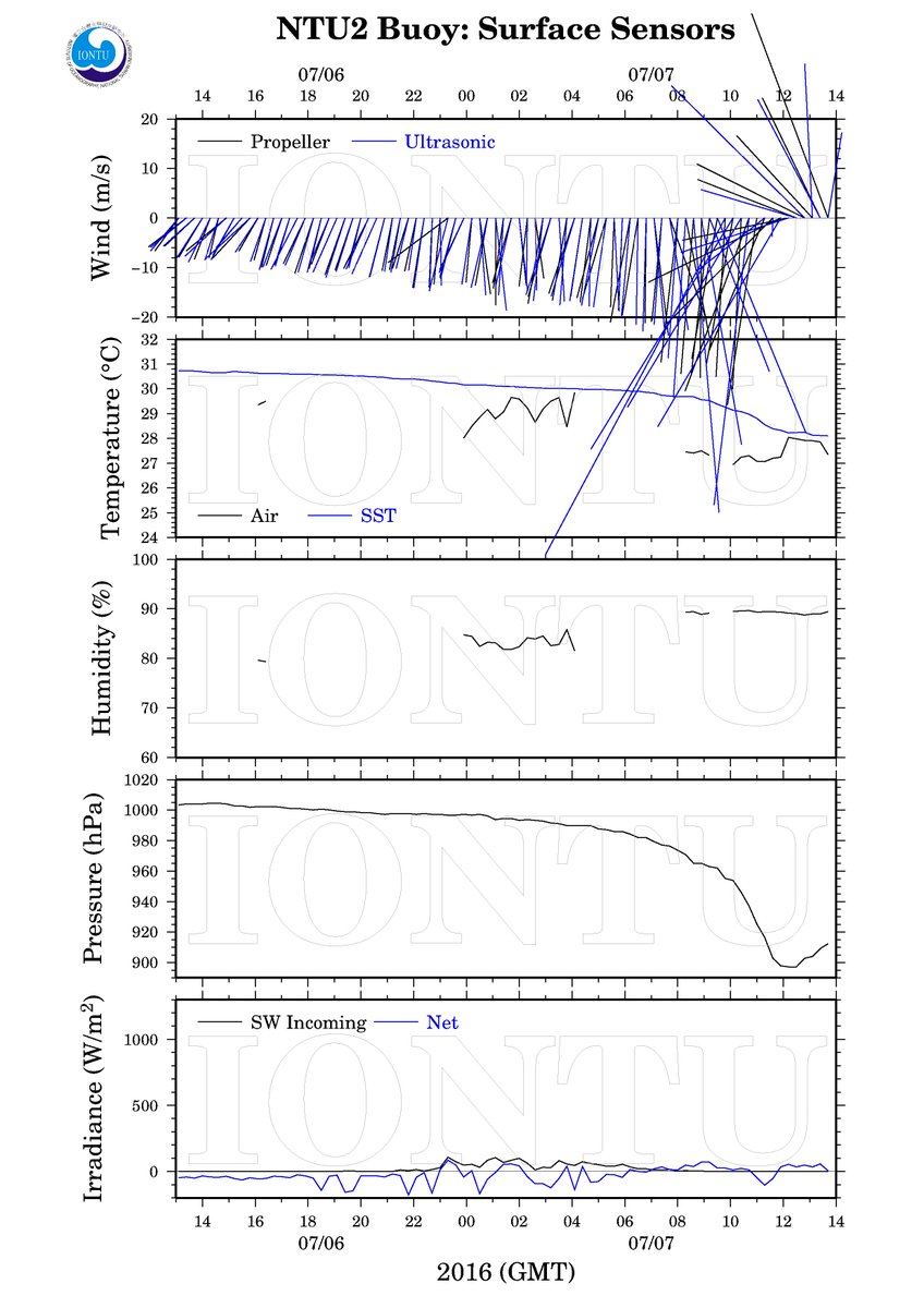
A National University of Taiwan buoy happened to sample the eye of Nepartak late Thursday night, local time, measuring a peak wind gust of 153 mph, followed by a minimum pressure of 897 millibars. It is rare for any surface observing system to measure such extreme wind speeds and low pressure while remaining intact.
Taiwanese buoy got into eye of Super Typhoon #Nepartak... and scored an 897mb pressure reading!
(MORE: Satellite Images Show Nepartak's Power)
Reconnaissance aircraft missions to precisely measure the typhoon's intensity are not flown over the western Pacific Ocean, by the way, but will resume in 2017.
Nepartak exploded from a tropical storm on July 4 to a Category 5 equivalent super typhoon the following afternoon.
Nepartak peaked Wednesday, packing maximum estimated sustained winds of 175 mph, becoming the strongest typhoon since Super Typhoon Souldelor in August 2015.
Nepartak's intensity bumped down a bit late Thursday night, Taiwan time (Taiwan is 12 hours ahead of U.S. EDT), due to the combination of undergoing an eyewall replacement cycle and the beginning of interaction of the circulation with Taiwan's mountainous terrain, according to tropical meteorologist Jose M. Garcia.
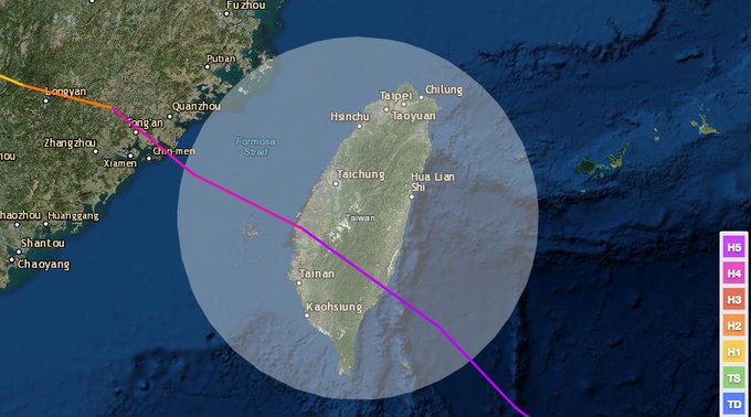
Nepartak came ashore near Taitung City in southeastern Taiwan as a Category 4 equivalent tropical cyclone shortly after 6:30 a.m. Taiwan local time.
Forecast
Typically,
typhoons nearing Taiwan will weaken a bit as the circulation interacts
with Taiwan's mountains. However, given its intensity, any weakening
prior to landfall appears to be largely academic from an impacts
standpoint.

Projected Path for Nepartak
Conditions
will continue to deteriorate along the eastern coast of Taiwan.
Battering waves, some coastal water rise, outer bands of locally heavy
rain and gusty winds will intensify into the overnight hours.
While
not as strong as the eyewall winds while over the ocean, Nepartak's
most intense winds may impact the more heavily-populated western coast
of Taiwan, including the capital city of Taipei, despite any potential weakening.
Over
one million customers may lose power from high winds in Taiwan.
Damaging winds, particularly to any poorly-built structures, and downed
trees can also be expected, especially in the eyewall.
Typhoon Soudelor last August triggered the largest power outage event in Taipower's history, leaving 4.8 million customers in the dark, according to Taiwan's Central News Agency.
As
with most of their tropical cyclones, potentially deadly flash
flooding, mud and rockslides are likely in Taiwan, as heavy rains pummel
the mountains of the island.
Last August, Soudelor produced over a foot of rain in Taipei, and over 50 inches of rain in a mountainous location in northern Taiwan.
The
heaviest rain is expected along and to the north and east of Nepartak's
track from Taiwan and the southwest Ryukyu Islands of Japan into
eastern China.

Rainfall Forecast
As
often occurs with tropical cyclones that make a northwest turn in this
region, a second swath of overrunning heavy rain may also develop over
parts of southwest Japan, including Okinawa's Kadena Air Base, which may
also trigger flash flooding.
Due to considerable
land interaction with Taiwan's terrain, Nepartak is excpected to have
weakened considerably by the time it makes its final landfall in eastern
China.
That
said, more locally heavy rain may aggravate any ongoing flooding and
trigger additional areas of flash flooding in eastern China this
weekend.
According to NOAA's historical hurricane tracks database, only one Category 5 equivalent super typhoon has made landfall in Taiwan in reliable records dating to 1971. That was Super Typhoon Bilis in August 2000.
Per NOAA hist. tracks, STY Bilis (Aug. 22, 2000) was only other Cat. 5 equiv. to landfall in #Taiwan dating to 1971.
Record Long Streak For Western North Pacific Ends
Prior to Nepartak's formation, not a single tropical storm, much less a typhoon (the term for a hurricane in the western North Pacific Basin), had formed west of the international date line since mid-December 2015. Typically this area is the world's busiest tropical cyclone corridor.This set a new record for the longest stretch without at least a single tropical storm in the western North Pacific basin in 66 years of records, according to Colorado State University tropical scientist Dr. Phil Klotzbach.
| Start, End Dates | Consecutive Days |
|---|---|
| Dec. 17, 2015 - July 3, 2016 | 200 |
| Dec. 15, 1972 - June 30, 1973 | 198 |
| Dec. 22, 1997 - July 7, 1998 | 198 |
By the end of June 2015, there had already been nine tropical cyclones in the northwest Pacific basin, including three super typhoons of Category 5 equivalent intensity.
Klotzbach also said Nepartak was the second latest first named northwest Pacific storm of the season on record, behind the record-late July 8, 1998's Tropical Storm Nichole.


No comments:
Post a Comment