Published: December 9,2015
In the middle of December, a robust storm system developing across the southern Plains would typically result in a significant snowfall across parts of the central to northern U.S.
Although such a storm is forecast this weekend, there may not be enough cold air in place to cause a substantial snow event, which is fairly unusual for this time of year. Warmer-than-average air continues to be the theme this December as we head deeper into the month.
(MORE: What a Warm December Means)
Later this week, a dip in the jet stream over the West is expected to set the stage for low pressure to develop over the southern Plains, strengthening into the Upper Midwest.
Out ahead of the storm, warm air will continue to prevail across much of the South and East. Some severe thunderstorms and heavy rain should also accompany the storm from the southern Plains into the Lower Mississippi Valley and Gulf Coast.
(MORE: Severe Storms May Return This Weekend)
A counter-clockwise flow around low pressure over the Plains would generally draw cold air into the backside of a storm developing in mid-December. For a variety of reasons, that does not look to be the case this weekend.
While some substantial snow is likely across much of the West and Rockies, trends suggest that the Plains and Midwest may not see much in the way of meaningful snow from this storm.
In addition to the potential lack of cold air, computer model forecasts also disagree with how the storm system evolves and where it tracks, further complicating the snowfall forecast.
Farther South Scenario: European Model
As of Tuesday evening, the European numerical forecast model suggests that the storm system will develop over Texas and wind up over the western Great Lakes this weekend, before ejecting northeast into Canada.European Model Snow Forecast
If such a scenario were to verify, snowfall amounts also look to be rather modest with most areas receiving less than six inches of snow in that narrow zone.
Farther North Scenario: GFS (American) Model
The American GFS forecast model shows a more northern track, laying down a stripe of snow farther north in the Plains, from eastern Colorado to the northern Great Lakes.American GFS Model Snow Forecast
However, even with such a scenario, snowfall amounts appear to be relatively unimpressive by December standards. The GFS only shows a small area of heavy snow, focused on a limited portion of the Upper Midwest.
It's worth noting there may be one or more weak weather systems that could each produce light to moderate snow over parts of the northern Plains and Upper Midwest Thursday into Friday.
Overall, the rather paltry -- both in areal coverage and amount -- snow from this weekend storm system may resemble more of an April system, rather than mid-December.
It's December, Why is it So Warm?
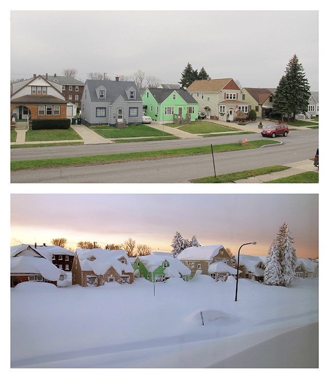
The jet stream remains displaced much farther north than is generally expected for this time of the year. The result is a surge of unseasonably warm air from the Plains, northward into much of Canada.Elsewhere, most of the country continues to experience these not-very-December-like temperatures. Buffalo, New York still has not seen any measurable snowfall this season, something that has not happened on record dating back to the late 1800s.
In the northern tier of states, through Dec. 7, International Falls, Minnesota, has seen their warmest first week of December on record, dating back 86 years. Although a somewhat shorter span of time, Minot, North Dakota, has also experienced their warmest first week of December over the past 66 years.
The current strong El Niño pattern not only favors the generally warm conditions that much of the country has been experiencing, but also suggests that it may continue into early 2016.
This year's El Niño has already set a monthly record for strength in November and could go on the become the strongest El Niño on record this winter.
#Buffalo street Fri. vs. 11/19/14 (AP/Carolyn Thompson). How long will #snow drought last? http://wxch.nl/1TLgaIf
(MORE: El Niño Sets November Record)
Despite the large-scale pattern, snow storms can still happen, even with a strong El Niño in place. This season was already off to a fast start with four named winter storms before the start of December.
It just may be a while before the next big snow-maker targets the nation's heartland.
Check back with us at weather.com for the latest forecasts to see when the next significant winter storm may threaten this part of the United States.
MORE: Snow Hits West, Nov. 10-11, 2015


No comments:
Post a Comment