Wednesday, April 2, 2014

Can Severe Weather Ever Be Avoided?

By Samantha-Rae Tuthill, AccuWeather.com Staff Writer
April 2,2014; 9:08PM,EDT
 
 
Severe weather can be both fear-inducing and awe-inspiring. The threat to lives and property that occurs during a severe weather event can create panic that lasts well after an event is over, even for people who did not live through the event themselves. People may cope with these fears by trying to find a way to take control of the situation, be it by preparing for an emergency weather event, living in an area where their most-feared weather threat is less likely, or for some, finding a cause of blame when tragedy does strike.
Related: U.S. Tops List of Natural Disaster Losses for 2012
Many times after a dangerous weather event occurs, some will be quick to blame the victims for not doing more to prepare, or even for choosing to live in an area where such events are likely to occur. However, with the United States' widely diverse geography and large population, is there really anywhere a person can live where they can expect to completely stay out of harm's way?
Earthquakes
Most of the most devastating earthquakes in U.S. history have occurred along the West Coast. Hardest hit have been Alaska, Hawaii and California, but Washington state and Oregon are not immune. This coast is part of the Ring of Fire, an area in the Pacific where plate boundaries meet and create numerous earthquakes and volcanic eruptions. When the plates move against one another, it creates seismic waves that can topple buildings. Earthquakes are most common along these lines; 81 percent of the largest earthquakes in the world happen in this region. Though more common in this region, they are possible elsewhere. While 81 percent may be a majority, that still leaves 19 percent that have occurred outside of this region.
To prepare for earthquakes, California buildings have different requirements than other parts of the country. The U.S. Geological Survey states that "building codes provide the first line of defense against future earthquake damage and help to ensure public safety." Specifications include the way walls are anchored and the supports in buildings.
Hurricanes
Hurricanes rank high among the the costliest U.S. disasters each year, with Hurricane Katrina still holding the top spot at over $100 billion. Entire towns can be leveled in a hurricane and the rebuilding process often takes a long time. It is no wonder that many may live in fear of hurricanes and the devastation they can bring, but is it enough to say that people who want to avoid a hurricane should just avoid the areas where they are most likely?
Hurricane Katrina spinning in the Gulf of Mexico. Photo by NOAA.
While hurricanes have areas they are more likely to target, due both to geographical and meteorological factors, Dr. Chris Landsea, science and operations officer for NOAA/NWS/NCEP/National Hurricane Center, said that any area along the coast is potentially at risk. With over 53 percent of the U.S population living near the coast, the potential for impacts are incredibly high.
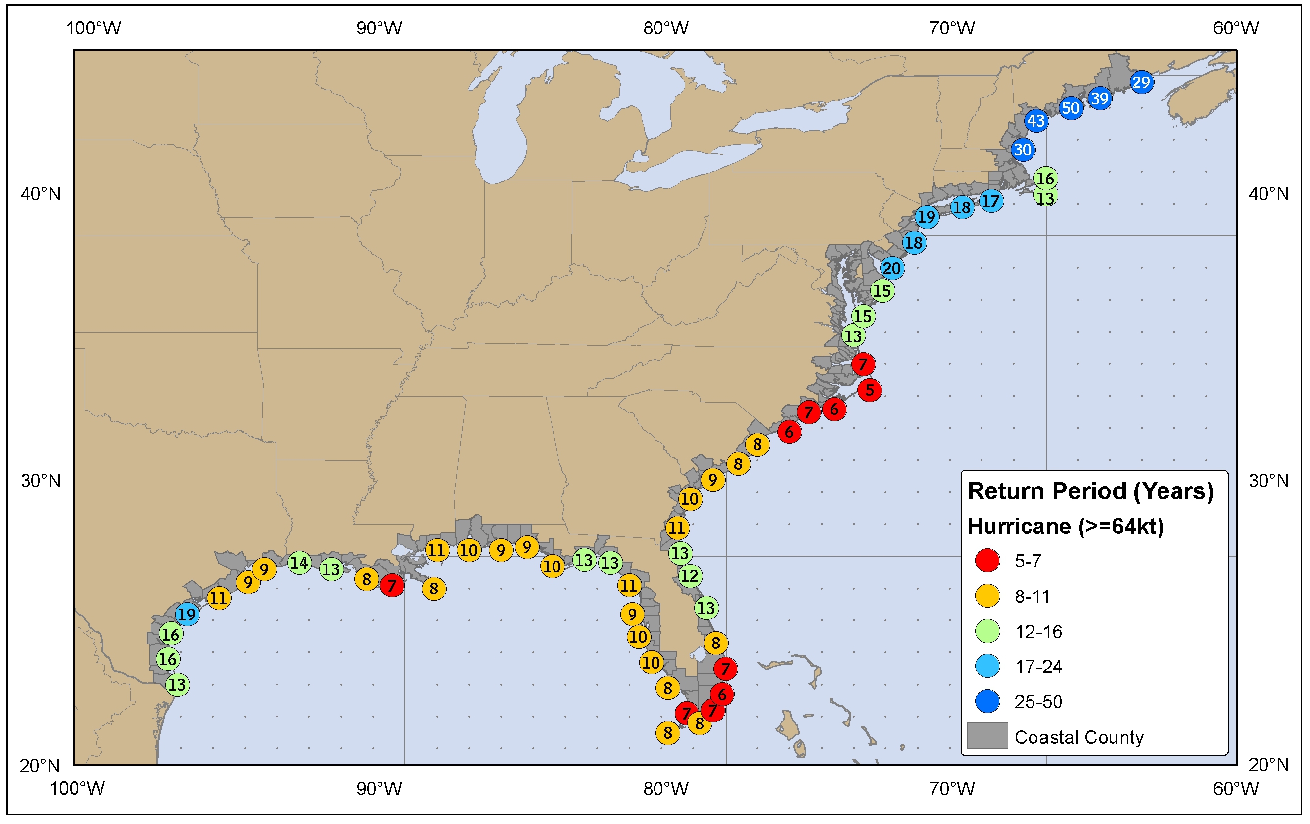
One of the areas most likely to be hit by a hurricane is southeastern Florida. Miami has a return period of six years, meaning that the city has an average risk of a hurricane coming within 50 miles of its coast every six years. This is due in part to its location near waters that are likely to have hurricanes form, along with the location of the city on a part of the state that juts out into the sea. Jacksonville, Fla., by comparison, has a return rate of 13 years. Though less than 350 miles away from Miami, Jacksonville's location farther north and slightly more west keeps it safer from a hurricane. Hurricanes will typically move in a more northern line by the time they are at the latitude of Jacksonville, bringing them a greater distance away from the coast.
Louisiana is another area prone to hurricane strikes, with a return period of seven to 14 years for spots along its coast. North Carolina which, thanks to its location farther out to sea than other Southeastern states, has a return period of five to seven years. While the Southeast coast has the highest probability of being hit by hurricanes, Landsea stated that any coastal area is potentially at risk. Though a storm of Sandy's strength hitting so far north was rare, it was by no means an entirely unlikely event. Even Pacific states can be susceptible, especially Hawaii. Though even rarer, hurricanes may also hit the West Coast. One did in 1858, and the chance that one could hit again cannot be ruled out.
Landsea also stressed that return rates are averages used to gauge the frequency of storms and are by no means a guarantee. Hurricanes won't return to Miami like clockwork every six years. They may also occur more frequently than the return period suggests.
"[Hurricanes] don't care what happened last year," Landsea said.
There are ways for people to prepare for hurricanes. One way is to be sure to have emergency plans, including those for pets, set well in advance of a storm. Evacuating before a storm hits is a crucial way to save not only the lives of those living in the threatened area, but also of emergency personnel. Preparing your home with the right building codes ensures the highest level of safety for property. Areas in Florida, for example, are required to have buildings that can withstand higher winds than area required of areas, in say, Ohio.
Tornadoes
Like hurricanes, tornadoes can be incredibly destructive, but have the additional stress of being much more challenging to predict. Storms that are likely to spawn tornadoes can be forecast to some degree. AccuWeather Meteorologist Dale Mohler said, for example, that in a thunderstorm where tornadoes are possible, they will typically come from the southern side of a storm. Stronger tornadoes are also generally associated with high surface relative humidity, making them less likely to carry significant strength in the Southwest. While these storms can be predicted, the exact moment and location of a tornado typically remains unknown until it starts to form. From there, the warning for where it will touch down could be under 20 minutes.
AccuWeather's Mike Smith, expert senior meteorologist and sr. vice president of AccuWeather Enterprise Solutions, said that the area most likely to get hit by strong tornadoes is central to southwestern Oklahoma. This location is more prone to tornadoes than anywhere else in the world. An area of the U.S. known as Tornado Alley has the overall strongest tornado possibilities. This strip of the country, extending from Texas to South Dakota into Iowa and southern Minnesota, is likely to have severe thunderstorms that will spin up tornadoes because of the clash of air that can occur in this region. Cold, dry air from the Rockies can move east and mix with warm, humid air off of the Gulf Coast. Add in the warm, dry air of the Southwest, and conditions are primed for deadly tornadoes.
Damage from a Lapeer County, Mich., tornado that hit March 15, 2012. Photo by gabes1976
So with the chances of tornadoes being so high, why would people choose to live there?
"I've lived in Tornado Alley my entire life and I love it," said Smith. "A non-weather place like San Diego, in spite of its other attractions, would bore me to tears. I love weather, and I love seeing the constantly changing majesty of Mother Nature."
Smith added that there is an appeal to living in this region even for those who are not as enthusiastic about weather as he is. "The friendly people [and] low cost of living, combined with a wonderful lifestyle."
He also noted that Forbes once said Wichita had the best quality of life for the price of any city in the U.S. It has also been ranked in the top 10 happiest cities to work in.
"[It] more than compensates for having to go to the basement once or twice a year," Smith said.
There have also been advances in technology that have made tornadoes easy to prepare for. Towns in Tornado Alley have tornado sirens and other emergency services that alert people to an incoming threat. People can build their own tornado shelters, and towns will have local emergency shelters for those who do not have their own. Smith noted in his book Warnings: The True Story of How Science Tamed the Weather, that an F5 tornado leveled 95 percent of the town of Udall, Kan., and resulted in numerous fatalities. A similarly sized town, Greensburg, Kan., was hit by an eerily similar tornado in 2007, which also leveled 95 percent of the town. But thanks to the advancements that have been made in warning systems, Greensburg, despite its higher population than Udall, saw one-fourteenth of the causalities.
While conditions are more likely to favor tornadoes in the central part of the country, tornadoes have been known to form in states across the U.S.
Fires
Areas to the west of Tornado Alley have threats of their own. The National Interagency Fire Center listed areas in California and the Southwest for having the highest risks for wildfires this summer. Nineteen of the top 20 fires that burned over 100,000 acres occurred in areas west of the Mississippi, most of them in Alaska with others in Oregon, Nevada, Oklahoma and Texas. Dry conditions and strong winds in these areas makes fires spark easily, whether from human-caused negligence or natural lightning from dry thunderstorms.
People in more fire-prone areas take precautions against creating and spreading the flames. Fire restrictions tell people when they cannot burn things on their property. Landscape and home care guidelines also help reduce risks. Educating people on how to contain fires, and how to properly dispose of flammable materials can help prevent them.
Photo by the Forest Service, United States Department of Agriculture via Wikimedia Commons.
Droughts
Fire dangers often coincide with droughts. Droughts cost the U.S. billions of dollars in lost crops and livestock, the residual effects of which can be felt for years. Not only do drought conditions increase the risk of fires, they can also cause dust storms. While drought effects can be felt on a national and even global scale, areas in drought are more likely to feel the impacts, including water restrictions. Lands can feel the devastation of drought to such an extent that soil compositions are changed and nutrients diminished, risking future growing efforts. For those living in drought areas, these conditions can drastically alter their livelihoods.
Drought conditions are strongest in the Southwest and Plains. Graphic by the U.S. Drought Monitor.
There are steps for residents of drought regions to take to help protect themselves from the dry conditions. Water conservation is especially key, from ceasing to wash cars with hoses to fixing leaky faucets. Improved irrigation and rain water collections also make surviving a drought a little easier for those who are prepared for it.
Snow and Ice
While concerns in the West are heavily influenced by dry and warm weather, the North is no stranger to disaster. Each winter, snow and ice storms close schools and businesses from across the northern Plains to New England. Power outages also take their toll, heating costs can be substantial and confined areas with closed windows help spread sickness.
Northerners are equipped to handle the conditions, however. Snow removal services, from sanding and plowing roads to shoveling public walkways, are enforced to help ease travel. Snow tires can also be placed on vehicles to make driving safer. For those used to snowy winters, storms that may bring activity to a halt in other regions are nothing remarkable.
The Psychology of Victim-Blaming
In the 3,794,101 square miles that make up the United States there are over 313.9 million people. To try to live in areas with no severe weather risks is impossible. Even areas that are less likely to see a certain extreme may not be immune. Earthquakes have hit Maryland. New Hampshire has had tornadoes. Snow has fallen in Georgia. Yet when a natural disaster strikes it is common to see comments blaming the victims for "choosing" to live in a location, as if they could have known for sure, as if the decision for where one lives can be entirely determined by an individual, independent of economic factors. Career paths need to be taken into account. With unemployment rates at 7.5 percent with many industries facing higher layoffs than others, not everyone has the option to decline a good job in their field because they are concerned about the weather in an area. Nor is it easy or affordable for people to up and move from a location they may have been born and raised by no choice of their own. So why might people claim to withhold any sympathy from natural disaster victims on the grounds that "it's what they get for living there"?
According to Dr. Rich Carlson, associate head professor of Psychology at the Pennsylvania State University, this may be partly contributed to Fundamental Attribution Error. It is a coping mechanism people may default to when they are afraid.
"People can look at what happens to themselves and know all the factors that lead to it," he said. "But they don't know some details for what may have impacted other people. They end up looking at another's situation and filter it through their own experiences instead and judge accordingly."
Essentially, it is a way for people to comfort themselves when they consider situations they may be afraid of. If they can say that there was a human fault that caused someone to be a victim, than they may be able to justify away their fears by assuring themselves that they won't be a victim because they did not or would make that decision. In the example of living in a severe weather location, the "decision" is to live in that particular area.
Similarly, Carlson explains how the Just World View may explain this mentality.
"People may protect themselves by trying to feel in control," he said.
For those thinking through the lens of the Just World View, in order to feel in control, they believe that the world needs to be just, that things happen for a reason and not at random. If tragedies happen at random than they cannot be controlled, and that thought is frightening to many people. In a Just World View, people may try to justify bad things by convincing themselves that victims had brought it on themselves, so that they may then "play by the rules" and stay safe from a similar occurrence. Carlson stated that people with more fear towards a specific event may be more likely to look for a human error to blame when the event happens. A person who finds tornadoes to be the most frightening kind of weather, for example, may be more likely to say that a tornado victim had it coming for living in central Oklahoma.
Sometimes it is the unknown elements of these types of weather that factor into the level of fear a person may have. Residents of North Carolina may scoff at panicked Northerners facing a potential hurricane, because Carolinians are used to hurricanes and are generally prepared to handle them. The idea of a giant blizzard may make them more uneasy, instead, because they do not have the same level of experience with them. It may seem scarier to think of an earthquake for someone who lives in Tornado Alley, because they may not be aware of the architecture codes that help keep buildings and people safe.
Tragedies happen. With the vast, varied landscape of the U.S., there are many different natural disasters that can affect the people who live here. A person may choose not to live near the coast to avoid hurricanes, but they may put them at a greater risk of tornadoes. People may live in mountains to avoid tornadoes, but it increases their risks for snowstorms or mudslides. Unprecedented snow or rain levels can cause houses near streams or rivers to have flooding that they have never seen before, but it may not be feasible for homeowners to relocate as a precaution. With over three million people living in the U.S., the few areas that may be statistically safer cannot possibly fit everyone. Even then, weather cannot be controlled, and areas that are less likely to be faced with a specific type of weather event may still experience one.
People will likely continue to try and find fault in others when a catastrophe occurs, but that only accomplishes a sense of safety for themselves that may often be unrealistic. To actually feel in control of a weather situation, people should have emergency plans for if a disaster does occur. They can also visit certified and reputable organizations such as the Red Cross to donate to those in need following a natural disaster.

On Social Media
Jared Mysko
jaredmysko
Massive area of Moderate Risk on Thursday in the Mississippi Valley for Severe Weather including Tornadoes spc.noaa.gov/products/outlo…
ShaeRozziFOX23
ShaeRozziFOX23
Tornado Watch in effect for parts of Green Country. LIVE Severe Weather Team coverage on @FOX23 News from 5-6:30. pic.twitter.com/lQzM8bfRxG
 

LIVE: Menacing Thunderstorms Ramp Up Across Kansas

By Kristen Rodman, AccuWeather.com Staff Writer
April 2,2014; 9:08PM,EDT
 
 
The first major severe weather outbreak of the spring season will ramp up with dangerous thunderstorms moving across Kansas, Missouri and Arkansas into Wednesday night.
A swath of thunderstorms will bring the risks of large hail, damaging winds and even some isolated tornadoes to the areas of Missouri and northern Arkansas later in the night.
As of 9 p.m. EDT severe thunderstorms were ramping up through Kansas.
Flash flooding will be another potential problem in the region as the storms fire up Wednesday. Travelers should be prepared for road and air traffic travel delays, flooded roadways and possible vehicle damage from hail.
RELATED:
Dallas to St. Louis on Alert for Dangerous Storms Wednesday
AccuWeather Severe Weather Center
The Rise of DIY Tornado Shelters

Areas at risk through Wednesday night include communities in Arkansas and Missouri.
As a part of a multiple-day severe weather event, severe weather will continue through the end of the week, taking aim next on 40 million people from the Gulf Coast to the Ohio Valley.


UPDATES: (All times are listed in EDT)

10:50 p.m. EDT Wednesday: A hail producing storm is heading towards the western suburbs of Kansas City. A trained spotter reported 1-inch diameter hail in Douglas County earlier form this storm.
9:40 p.m. EDT Wednesday: Heavy rain totaling 2.09 inches in Effingham, Ill., according to Mesonet.
9:03 p.m. EDT Wednesday: Golf ball sized hail and hail totaling more than two inches has been reported in Allen County, Kan., according to NWS spotters.
6:55 p.m. EDT Wednesday: Watch this evening's edition of AccuWeather LIVE for the latest on the severe thunderstorms firing up across Kansas:
12:45 p.m. EDT Wednesday: Parts of Homer Adams Parkway Route 3 Underpass are flooded with water flowing underneath the pass in Alton, Ill., reports an NWS spotter.
11:40 p.m. EDT Wednesday: Ping-pong ball-sized hail fell in Waterloo, Ill., according to an NWS spotter.

On Social Media
Daniel Rapkin TAV
TAVweather
THE NATIONAL WEATHER SERVICE IN WICHITA HAS ISSUED A * SEVERE THUNDERSTORM WARNING FOR... EASTERN RENO COUNTY IN SOUTH CENTRAL KANSAS
Warren Faidley
WarrenFaidley
Tomorrow could be a dangerous day for severe weather. The SPC has issued a Moderate Risk. As always, risk level... fb.me/2wqZX4A7n
A~
RES911CUE
Moderate risk of severe weather Thursday: Tornadoes, dangerous storms possible in red area spc.noaa.gov/products/outlo… pic.twitter.com/hFqo6bL86s"
Josh Fitzpatrick
WSAZJoshFitz
Periods of rain and thunderstorms Thursday into Friday. Severe weather risk Friday. Damaging winds possible. #WSAZ
Wendell L. Malone
KE5WLM
High Winds - Blowing Dust - Critically Dangerous Fire Weather Conditions - Severe Thunderstorms. senmwx.com/?m=1 #nmwx #txwx
 

World Weather Hot Spot for April 2-3,2014 from accuweather.com

Hilo,Hawaii,USA: Very heavy rain;received a whopping 8.85 inches of rain Monday-Tuesday (March 31-April 1,2014)

Today's Worst Weather for April 2,2014 from accuweather.com

Cave City,Missouri: Rain and Thunderstorms

Death Toll Climbs After Magnitude-8.2 Quake Strikes Near Chile

By Mark Leberfinger, AccuWeather.com Staff Writer
April 2,2014; 9:07PM,EDT
 
 
The location of the earthquake, (Image/USGS)
A magnitude-8.2 megathrust earthquake struck late on Tuesday off the coast of northern Chile and produced a large tsunami, according to U.S. officials.
The quake, which was at a depth of 6 miles and initially rated as a magnitude 8.0, occurred at 4:47 p.m. PDT, according to the United States Geological Survey. Thirty-six aftershocks have been reported since the major quake including a recently strong 7.8 magnitude earthquake that struck at 7:58 p.m. PDT Wednesday.
So far, there have been six deaths as a result of this earthquake, according to the Associated Press.

The Chilean earthquake was detected on a seismograph in the Woolly Hollow State Park in central Arkansas. (Photo/Arkansas Seismic Network, Arkansas Geological Survey)
The 8.2 quake was the result of a megathrust between the Nacza and South America plates near the Chilean coast, the USGS said on its website. The website also showed more than two dozen aftershocks ranging from magnitudes of 4.7 to 7.8.
Chilean officials ordered a coastline evacuation as a result of the quake, The Associated Press reported.
Chilean President Michelle Bachelet said she declared a state of emergency to "avoid situations of looting and disorder, along with collaborating with the authority of the area in the relief efforts that have already begun."
The earthquake resulted in landslides that blocked roads and caused power outages for thousands of people. An airport was also damaged by the quake while many fires destroyed businesses and homes in the region.
Tsunami heights as high as 7.6 feet were reported at Pisagua, Chile, the U.S. National Tsunami Warning Center (NWTC) said.
The quake caused tsunami warnings to be issued for Chile, Ecuador, Panama and Peru. Tsunami watches were issued for Colombia, Costa Rica, El Salvador, Nicaragua, Mexico, Guatemala and Honduras, the U.S. center said.
These watches and warnings were all canceled by the center on Tuesday night after the threat of a tsunami had passed.
The NWS Pacific Tsunami Warning Center said that a tsunami wave of 1.9 feet occurred at Hilo, Hawaii, on Wednesday morning. Kahului, Maui, reported a wave of 1.7 feet. The wave was 1 foot high in Pago Pago, the capital of American Samoa.
A tsunami advisory previously issued for Hawaii was canceled Wednesday morning, local time by the Pacific center.

This chart shows the high-water levels associated with the tsunami that moved past Hilo, Hawaii, on Wednesday, April 2, 2014. (Photo/NOAA National Ocean Service)
A much smaller wave occurred along the California coast. The largest California wave was 0.6 feet at Port San Luis.
Dry weather is in store over the next few days in the Chilean city of Iquique as building inspections and cleanup from the earthquake begin.
Authorities were trying to round up about 300 female inmates who escaped from a prison after the earthquake in Iquique, the Associated Press reported. About two dozen were captured. The escape caused Peru to close its border with Chile.

U.S. officials were analyzing the possible tsunami threat to Hawaii and the West Coast. This is a energy map showing the forecast of tsunami waves throughout the Pacific Basin. (Photo/NOAA National Tsunami Warning Center)
Major earthquakes are not uncommon in Chile.
A March 16 earthquake in the same region registered a magnitude 6.7, according to the USGS. More than 60 quakes greater than magnitude 4, and 26 magnitude-5 quakes have occurred since, including three magnitude-6.2 quakes.
An 8.8-magnitude quake rocked Chile in February 2010 offshore 200 miles from Santiago, the nation's capital. The world's largest earthquake, a magnitude 9.5, also struck the country in May 1960.

A buoy, belonging to the Hydrographic and Oceanographic Service of the Chilean Navy, off the coast of northern Chile detected the magnitude-8.2 earthquake Tuesday, April 1, 2014, which shows the water column height before and after the quake. (Photo/NOAA National Data Buoy Center)
Meteorologist Eric Leister contributed to this story.

On Social Media
BERNAMA Radio24
bernamaradio24
A 8.2-mag earthquake hit northern Chile's Pacific coast today, killing at least 6 people as tsunami waves of more than 2m lashed the shore
Tony Potts
TonyPotts1
NOAA animation of Chile #earthquake and #tsunami waves the moment quake hit. m.youtube.com/watch?v=k1IQbZ…
 

Dallas: Severe Storms Move in for Midweek

By Mark Leberfinger, AccuWeather.com Staff Writer
April 2,2014; 9:06PM,EDT
 
 
The chance of showers and thunderstorms will increase for midweek in the Dallas area.
For the first few days of April, temperatures will remain slightly above average, hovering in the high 70s and low 80s.
The greater chance for thunderstorms will arrive Thursday with some stronger storms possible.
"Through Thursday, there is a slow-moving storm system off to the north," AccuWeather.com Meteorologist Andy Mussoline said. "The threat for severe weather could re-fire across the area on Thursday."

RELATED
Detailed Dallas Forecast
Eastern Texas Interactive Radar
Forecast Temperature Maps

One more day in the low 80s is expected Thursday before the temperature drops into the upper 60s on Friday with sunny skies and breezy conditions.
"It's going to be quiet Friday into Saturday," he said, adding the weather should remain mild into the early weekend.


On Social Media
AccuWeather.com News
LIVE: Snow, Ice Expected Across Ohio Valley, South
A storm system will bring snow and ice to parts of the mid-Atlantic and the South through Monday. "Snow will spread along the Ohio River thi...
Mike Smith
USWeatherExpert
Mike Smith Enterprises Blog: Severe Thunderstorm Watch Central Kansas meteorologicalmusings.blogspot.com/2014/04/severe…
2h
 

WeatherWhys for April 2,2014 from accuweather.com

Sunburns are quite common during the month of April. The reason for this is that people do not protect themselves as much as they do in the summer since they may think the cooler air will protect them. The April sun is just as strong as the August sun.

Pittsburgh to be on Fringe of Severe Weather

By , Expert Senior Meteorologist
April 2,2014; 9:01PM,EDT
 
 
In addition to warm weather into the end of the week, the Pittsburgh area will be on the fringe of severe weather from the Midwest.
High temperatures for the remainder of the week will range from near 60 to near 70 F.
The typical high for the city during early April is 57 F.

The week will not be free of rain, however.
Rounds of heavy rain and severe thunderstorms will target areas to the west through Friday.
As these storms move eastward they will weaken, but periods of rain are in store Thursday into Friday. There is the chance of locally heavy, gusty thunderstorms reaching the area on Friday.
Rounds of rain are forecast Thursday into Friday.
The weekend will be cooler with spotty showers and a brisk wind on Saturday. Sunday will be the nicer of the two days with little wind, some sunshine and rebounding temperatures.
RELATED:
Detailed Pittsburgh Forecast
Brutal Winter Bogged Down Car Sales But Spring Brings Hope
Tornado Threat Ramps Up on the Plains This Week


Tune in to AccuWeather LIVE Midday every weekday at noon EDT. We will be talking about the mild weather and where severe thunderstorms are most likely to occur.


On Social Media
Mike Smith
USWeatherExpert
Thunderstorms moving into S. Sedgwick Co. Hail possible. Moving ENE. pic.twitter.com/8lFOuhOAuM
 

RADAR: Track the Severe Storms Across Kansas

By Kristen Rodman, AccuWeather.com Staff Writer
April 2,2014; 9:00PM,EDT
 
 
A series of severe thunderstorms will roll through areas of Kansas, Missouri and Arkansas Wednesday night.
The severe weather outbreak will bring threats of strong thunderstorms, large hail, damaging winds, flooding and even some isolated tornadoes, which may halt both air and roadway traffic through Wednesday night.
RELATED:
Thursday Tornado Risk Zone Spans 1,000 Miles, Population of 40 Million
AccuWeather Severe Weather Center
The Rise of DIY Tornado Shelters

The next phase of the severe weather will take aim at nearly 40 million people on Thursday.
For live updates on the severe weather outbreak, read this story .

South Central Regional Radar:


Dallas Radar:


Wichita, Kan., Radar:


Oklahoma City Radar:


Little Rock, Ark., Radar:


St. Louis Radar:


On Social Media
Hutchinson Police
HutchPD
SEVERE THUNDERSTORM WARNING FOR... EASTERN RENO COUNTY IN SOUTH CENTRAL KANSAS... * UNTIL 800 PM CDT * AT 732... fb.me/3QBsGAqoF
Daniel Rapkin TAV
TAVweather
THE NATIONAL WEATHER SERVICE IN WICHITA HAS ISSUED A * SEVERE THUNDERSTORM WARNING FOR... EASTERN RENO COUNTY IN SOUTH CENTRAL KANSAS
1350 KMAN
1350kman
THE NATIONAL WEATHER SERVICE IN TOPEKA HAS ISSUED A * SEVERE THUNDERSTORM WARNING FOR... CENTRAL GEARY COUNTY...
 

Brutal Winter Bogged Down Car Sales But Spring Brings Hope


By Jenna Abate, AccuWeather.com Staff Writer
April 02, 2014; 9:00 PM
The harsh winter of 2013-2014 took a toll on car sales, but analysts are hopeful that spring will bring a boom in sales.
This winter, the Northeast was reminded what it feels like to have below-freezing temperatures for an extended period of time, with many cities enduring one of the coldest winters in 20 years. The South dealt with immobilizing rounds of snow and ice. Repeated snowstorms pummeled the Midwest, causing seasonal snowfall records to fall for some major cities.
RELATED:
INFOGRAPHIC: Where Would Winter Temperatures Place Your City in the US?
Winter Freezes Up Delivery for Small Businesses Across Midwest
One of the Coldest Winters in 20 Years Shatters Snow Records

There is no direct correlation between wintry weather and car sales but statistics show a relationship between the two. Analysts said that both the fleet side and the retail side of the business have seen significant decreases over the past few months but are hopeful for the spring season ahead.
Kelley Blue Book Senior Analyst Karl Brauer said there should be an increase of sales once the temperatures start to increase. The crawl out of slower winter sales will come as much-needed relief.
"The cold weather had an undeniable impact on car sales at the start of the year. A rebound in sales for the Midwest and Northeast regions is occurring right now, and should counter the polar vortex that chilled sales during January and February," Brauer said.
Even March had unusually cold weather, taking a toll on what would have been a month for increased sales.
"Last month, we definitely saw an effect from the weather, especially in the Northeast. Come the end of March, we predict a return to normal," Carly Schaffner of Toyota Media Relations said.
March kicked off the spring selling season and Toyota is looking forward to putting the winter of delayed purchases and slow sales behind them.
Toyota released a statement on March 3, 2014, citing that recent economic reports indicate the unusually harsh winter and how it continues to have an effect on the economy, in general. The weather certainly had an impact on auto sales in February.
Balloons fly over snow-covered cars for sale in Louisville, Neb., Thursday, Feb. 24, 2011. (AP Photo/Nati Harnik)
Ford Sales Analyst Erich Merkle said that as far back as January, logistics show that weather delayed the making and shipping of model parts to different ends of the U.S.
"In January, on our fleet side, we were about 4,000-5,000 production parts behind and we had to make up for that in February and then in March. But March sales are much better and this comes as welcomed news," Merkle said.
Ford isn't the only company who had complaints about this winter affecting both the fleet side and the retail side of the business.
"Across the board, weather hasn't been kind to fleet or retail for that matter. People in areas like the Northeast, Great Lakes, even in Georgia and Florida, with adverse weather didn't want to go car shopping on a 12-degree day," Brauer said.
Brauer compiled a list that shows the shift in sales during the cold-weather months as well as the regional share of new car registrations in the second quarter of the year (April-June) when there is a general warmup.
"It looks like the most affected region was the Mideast (Washington, D.C., Delaware, Maryland, New Jersey, New York, Pennsylvania), where there was a drop in market share of between 3 to 3.5 percent for two weeks in early February. It looks like the same exact thing happened one year earlier, just showing the impact of severe storms. Hurricane Sandy is responsible for the big drop in 2012," Brauer said.

The vertical bar represents the Mideast region percent of retail sales, while the horizontal accounts for the week of the year. In 2014, there is a significant dip between weeks seven to nine where the Mideast had a big snowstorm right around Valentine's Day.
Here's a look at spring new car registrations from 2012, showing that people are in the buying mood once it thaws out:
Region
Percent of Calendar Sales in Quarter Two (April-June)
New England
27.8%
Rocky Mountain
27.8%
Great Lakes
27.2%
Mideast
27.0%
Far West
26.8%
Plains
26.5%
Southwest
26.0%
Southeast
25.9%
"Retail won't be nearly as hampered during the spring because it's not as hard to get out and shop for a car," Merkle said. "Customers don't have to worry about the cold, snow or power-outs."
While a chill is expected to linger into April for portions of the Midwest, Ohio Valley and far interior Northeast, it will warm up quicker for the balance of the South and East, according to the AccuWeather long-range forecasting team.
"Annually, we see that there is a weather element that generally slows sales in the beginning of the year, but when the weather turns we'll see a serious kick-up when it becomes more favorable outside," Brauer said.

On Social Media

Jenna_Abate

Time for a new car? READ: Brutal Winter Bogged Down Car Sales But Spring Brings Hope via @accuweather! bit.ly/1lC9OwT

LilyLuWhoT

@Bea_Bells @ourChloePup I hope we all get some nice Spring weather soon! We deserve it - has been a loooong winter! ((HUGS)) Luv yoo! OxO

AnjaGarcia

@Aimeelou12686 winter weather makes me sleepy too.. Hopefully spring weather is around the corner for you!

AshleyGuptill

My poor little car has taken quite the beating this winter. Two run ins with the snow bank this morning. Where is the warm Spring weather?

esqcapades

@TORARADICAL awww, sorry. I can imagine that you're sick of snow. We had a brutal winter here too. I hope you get spring soon!

CyG_cars

Brutal Winter Bogged Down Car Sales But Spring Brings Hope #NewsAd link CyG-NewsAgent.net/NewsAd.php?url…


National Temperature and Rainfall Extremes for April 2,2014 from accuweather.com

As of 11PM,EDT/8PM,PDT


Daily U.S. Extremes

past 24 hours

  Extreme Location
High 100° Laredo, TX
Low -11° Hallock, MN
Precip 2.53" Saint Louis, MO

Tuesday, April 1, 2014

Deadly Earthquake Strikes Near Iquique, Chile; Tsunami Warnings Remain for Chile and Peru

By: Associated Press
Published: April 1,2014


A powerful magnitude-8.2 earthquake struck off Chile's northern coast Tuesday night, causing landslides that blocked roads and setting off a small tsunami that forced an evacuation of coastal areas, but the region apparently escaped major damage and casualties.In the city of Arica, 86 miles from the quake's epicenter, minor injuries were reported and some homes made of adobe were destroyed, officials said. The quake shook modern buildings in nearby Peru and in Bolivia's high altitude capital of La Paz.
The U.S. Geological Survey initially reported the quake at 8.0, but later upgraded the magnitude. It said the quake struck 61 miles northwest of the Chilean city of Iquique at 8:46 p.m., hitting a region that has been rocked by numerous quakes over the past two weeks.
Background

Earthquake Magnitude

Earthquake Magnitude
 
Background

Current Tsunami Alerts

Current Tsunami Alerts
 Psychiatrist Ricardo Yevenes said he was with a patient in Arica when the quake hit. "It quickly began to move the entire office, things were falling," he told local television. "Almost the whole city is in darkness." The quake was so strong that the shaking experienced in Bolivia's capital about 290 miles (470 kilometers) away was the equivalent of a 4.5-magnitude tremor, authorities there said.At least eight strong aftershocks followed in the first few hours, including a 6.2 tremor. More aftershocks and even a larger quake could not be ruled out, said seismologist Mario Pardo at the University of Chile.
Chilean Interior Minister Rodrigo Penailillo said President Michelle Bachelet was closely watching the situation and was ready to take "any measures" to ensure people's safety. Hundreds of soldiers were being deployed in the quake zone, and a flight would be leaving soon with 100 special forces on board, he added.
"We have taken action to ensure public order in the case of Iquique, where we've had a massive escape of more than 300 female prisoners from the Iquique jail, so that the armed forces and police can coordinate and provide tranquility and security to the residents," he said.
Some roads in northern Chile were blocked by landslides, causing traffic jams among people leaving the coast. At least two fires were reported in Iquique, according to Chilean Financial Journal Online. The local airport was closed because of structural damaged, the Journal said.  Coastal residents of northern Chile evacuated calmly as waves measuring almost 6.5 struck their cities.Evacuations also were ordered in Peru, where waves 2 meters above normal forced about 200 people to leave the seaside town of Boca del Rio. But there were no injuries or major damage, said Col. Enrique Blanco, the regional police chief in Tacna, a Peruvian city of 300,000 near the Chilean border. "The lights went out briefly, but were re-established," Blanco said.
But there were no injuries or major damage, said Col. Enrique Blanco, the regional police chief in Tacna, a Peruvian city of 300,000 near the Chilean border. "The lights went out briefly, but were re-established," Blanco said.
The Pacific Tsunami Warning Center issued an alert for all of Latin America's Pacific coast, all of which have since been cancelled with the exception of Chile and Peru. A tsunami warning remains in effect for Chile and Peru.
Chile is one of the world's most earthquake-prone countries. A magnitude-8.8 quake and ensuing tsunami in central Chile in 2010 killed more than 500 people, destroyed 220,000 homes, and washed away docks, riverfronts and seaside resorts.The strongest earthquake ever recorded on Earth also happened in Chile -- a magnitude-9.5 tremor in 1960 that killed more than 5,000 people.
Hundreds of earthquakes have shaken Chile's far-northern coast in the past two weeks, keeping people on edge as scientists said there was no way to tell if the unusual string of tremors was a harbinger of an impending disaster.The latest activity began with a strong magnitude-6.7 quake on March 16 that caused more than 100,000 people to briefly evacuate low-lying areas. Hundreds of smaller quakes followed in the weeks since, keeping people on edge as scientists said there was no way to tell if the unusual string of tremors was a harbinger of an impending disaster.
Chile is the world's leading copper producing nation, and most of its mining industry is in the northern regions. Top mining companies said there was no serious damage to their operations so far.

Potential U.S. Impacts?

U.S. officials say they've found no threat of a tsunami along the coasts of Alaska, California, Oregon or Washington, but the danger to Hawaii is still under evaluation.
Bill Knight, a scientist at the National Tsunami Warning Center, says early data show that by the time waves generated the magnitude-8.2 quake reach the West Coast, they'll be too small to pose any threat. Hawaii faces greater potential danger, but analysts are still assessing the threat and no warning has been issued. The Pacific Tsunami Warning Center says if tsunami waves are generated, the earliest they'd hit Hawaii is 3:24 a.m. Wednesday Hawaii Standard Time. Elsewhere in the Pacific, New Zealand has issued a statement of "no threat" to the country due to the situation. The country of the Philippines states that they are monitoring the threat, but no evacuation orders have been given at this time. Japan is still evaluating the threat, but no tsunami alerts have been issued.This is a breaking news situation. Please check back for updates.


8.2 Earthquake Rocks Chile

A massive earthquake off the coast of Chile has sparked tsunami warnings for the entire Pacific Coast of Latin America.


#Chile ATTN! MT @INFORMADORCHILE Se informa que en la playa de #Cartagena se está recogiendo el mar. pic.twitter.com/nfsYy1gffz |#Teremoto


Evacuan a enfermos


  BBC World Service        ✔ @bbcworldservice
"I was on my bed, the room was shaking," local in Chile tells what earthquake felt like http://bbc.in/1foIIFh 


The Weather Channel        ✔ @weatherchannel
Philippine authorities say NO threat of in the Philippines from the M8.2 near Chile (PDF file): http://wxch.nl/1icBjrf 


National Weather Summary for April 1,2014 from weatherunderground.com

Weather Underground midday recap for Tuesday,April 1,2014

A low pressure system lingered over the West Coast on Tuesday, while a cold frontal boundary extended from the Southwest to the upper Midwest.

An area of low pressure inched south southeastward along the coast of northern California on Tuesday. This system brought scattered showers and thunderstorms to parts of Oregon, Idaho and California, while high elevation snow showers occurred across the Cascades and the parts of the Sierra Nevadas. Winter weather advisories remained in place across the central Sierra Nevadas as this low pressure system approached the region. Mono, Calif., reported a morning total of 20.0 inches of snow, while Placer, Calif., reported a morning total of 16.0 inches of snow. Meanwhile, a cold front stretched from southern California to Colorado. Snowy conditions moved across the Rockies and parts of the central Plains. Roberts, S.D., reported a midday total of 3.0 inches of snow.

A separate cold front stretched from New Mexico to Minnesota. Winter weather advisories were issued in northeastern Minnesota as snow showers moved across the upper Midwest.

The eastern third of the country avoided precipitation on Tuesday. High pressure over Florida brought warm, muggy conditions to the Gulf Coast. Laredo, Texas, recorded a midday high of 86 degrees, while Barnwell, S.C., recorded a midday high of 84 degrees.

This Date in Weather History for April 1,2014 from weatherforyou.com

Weather History
For Tuesday,April 1,2014


1912 - A tornado with incredible velocity ripped into downtown Houston, TX, breaking the water table and giving the city its first natural waterspout. (The Weather Channel)
1923 - Residents in the eastern U.S. awoke on "April Fool's Day" to bitterly cold temperatures. The mercury plunged to -34 degrees at Bergland MI and to 16 degrees in Georgia. (David Ludlum)
1987 - Forty-five cities across the southeastern U.S. reported record low temperatures for the date. Lows of 37 degrees at Apalachicola FL, 34 degrees at Jacksonville FL, 30 degrees at Macon GA, and 22 degrees at Knoxville TN, were records for April. (The National Weather Summary)
1987 - A tornado touched down briefly during a snow squall on the south shore of White Fish Bay (six miles northwest of Bay Mills WI). A mobile home was unroofed and insulation was sucked from its walls. (The Weather Channel)
1988 - A powerful spring storm produced 34 inches of snow at Rye CO, 22 inches at Timpas OK, 19 inches at Sharon Springs KS, and up to 35 inches in New Mexico. Severe thunderstorms associated with the same storm spawned a tornado which caused 2.5 million dollars damage at East Mountain TX. (The National Weather Summary) (Storm Data)
1989 - Up to six inches of snow blanketed the Adirondacks of eastern New York State and the Saint Lawrence Valley of Vermont. Up to a foot of snow blanketed the Colorado Rockies. (Storm Data) (The National Weather Summary)
1990 - Thunderstorms produced severe weather in Texas, from southern Arkansas and northern Louisiana to southern Georgia, and from northern South Carolina to the Upper Ohio Valley during the day and evening. Thunderstorms spawned a tornado at Evergreen AL, and there were more than eighty reports of large hail and damaging winds. Thunderstorms produced baseball size hail north of Bastrop LA, and produced damaging winds which injured one person west of Meridian MS. (The National Weather Summary) (Storm Data)

National Temperature and Rainfall Extremes for April 1,2014 from accuweather.com

As of 11:45PM,EDT/8:45PM,PDT


Daily U.S. Extremes

past 24 hours

  Extreme Location
High 92° Presidio, TX
Low -10° Hettinger, ND
Precip 1.08" Sacramento, CA