Sunday, April 30, 2017

Preparing for the costliest weather disaster in the US: How to stay safe before, during and after a flood


By Stephanie Koons, AccuWeather staff writer 
 
 
Floods may not inspire as much fascination and terror as hurricanes and tornadoes, but they can be just as devastating and cause destruction on a more massive scale. Knowing what to do before, during and after a flood can save your life and help minimize the damages to property.
“Floods are the most common and costly disasters we see in the U.S.,” said Rafael Lemaitre, director of public affairs for the Federal Emergency Management Agency (FEMA).
More deaths occur from flooding than any other hazard except for heat-related fatalities, according to the National Weather Service (NWS). The national 30-year average for flood deaths is 127, compared to a 30-year average of 73 deaths for lightning, 68 for tornadoes and 16 for hurricanes.
“Anybody who lives near any size water really needs to be cognizant,” said Katie Collins Garrett, a meteorologist and communications specialist for the National Oceanic and Atmospheric Administration (NOAA).
Staying out of harm's way
According to Garrett, nearly all flood fatalities can be prevented by following one simple rule.
“The number-one thing is turn around and don’t drown,” she said. “Absolutely don’t go into floodwaters."
flooding
Flooding was reported at the University of Georgia. (Photo/Instagram user cin.aed)

A major cause of flood fatalities, Garrett said, is people driving into floodwaters. This is a particularly high risk during flash floods, which occur when excessive water fills normally dry creeks or river beds along with currently flowing creeks and rivers.
Flash floods, according to the National Severe Storms Laboratory (NSSL), are the most dangerous kind of floods, because they “combine the destructive power of a flood with incredible speed and unpredictability.”
During a flood emergency, Lemaitre said, it is important for people to heed the instructions from local officials, such as staying off the road. To stay up-to-date on new developments, people can sign up to receive text alerts from state and local governments and follow government officials on social media.
"They are providing information that could potentially save your life,” Lemaitre said.
A particularly effective way to stay updated during a flood emergency, Lemaitre said, is downloading the FEMA App, which is available for Apple, Android and Blackberry mobile devices. Users of the app would be able to receive weather alerts from the NWS for different locations, tips on what to do during floods or other natural disasters and information on open shelters.
Additional ways that people can prepare for floods, Lemaitre said, include stocking food, water and supplies to last three days and practicing disaster planning as a family.
"The better prepared people are for disaster, the faster they can bounce back,” he added.
Where to go for help during a flood
In the event of an evacuation, various churches, community and nonprofit organizations provide shelter for displaced individuals and families. The American Red Cross, according to its website, helps disaster victims by providing safe shelter, hot meals and essential relief supplies. The Red Cross also supports emergency workers, links family members outside the disaster area and provides blood and blood products to disaster victims.
During a flood, affected areas may experience power outages, making communication difficult or impossible.
According to Safewise, FEMA and the FCC both recommend keeping a corded phone in the home, since an old-fashioned phone with a cord will still work even during a power outage. Safewise also advises having a NOAA weather radio on hand. These radios usually contain a battery as well as a hand crank. They often have an outlet for charging a cell phone and some even have flashlights.
NOAA radios are useful for getting accurate weather information during storms and power outages. Also, Safewise advises to enter “In Case of Emergency” cell phone contacts that can be reached by emergency personnel.
People are increasingly relying on social media to communicate with friends and family during emergency situations.
In 2014, Facebook launched Safety Check, a feature activated by the company during natural or man-made disasters to determine quickly whether people in the affected geographical area are safe.
If it looks like you may be near a major crisis, Facebook will send a notification asking if you're safe. If you're OK, click or tap the "I'm Safe" button to share the news with your friends and loved ones.
Dealing with flood aftermath
While drowning is a major risk of flooding, some of the most potent dangers stem from contaminants in floodwaters.
According to the Center for Disease Control (CDC), floodwaters and standing waters pose various risks, including infectious diseases, chemical hazards and injuries connected with downed power lines. Floodwater often contains infectious organisms, including intestinal bacteria such as E. coli, Salmonella and Shigella, according to a report by the Occupational Safety and Health Administration (OSHA).
“A lot of times people don’t realize how gross floodwaters are,” Garrett said.
RELATED:
WATCH: What to do when driving in floodwaters
Prepare for severe weather with a weather radio
VIDEO: What to do immediately after a tornado hits

In the aftermath of a flood, she added, homeowners should consider hiring environmental remediation experts to do a deep clean and check their homes for structural issues. In the event of an evacuation, people should turn off the power and unplug any electronic devices to prevent electrocution.
Protecting your property through flood insurance
In addition to preparation and safety measures, homeowners need to consider how to deal with the financial damage wrought by flooding. Since flood damage is not covered under homeowner insurance policies, purchasing flood insurance is necessary to safeguard assets in the event of a flood.
“Flood insurance is the only way you can protect yourself,” Lemaitre said.
Many people don’t purchase flood insurance because they believe they are not at risk, he added. However, according to FEMA, more than 20 percent of flood insurance claims come from people outside of mapped high-risk flood areas. The average annual cost for flood insurance is just $400 to $600 for people living in low-risk areas, Lemaitre said. From 2011 to 2015, the average flood claim amounted to more than $46,000.
The National Flood Insurance Program (NFIP), which is administered by FEMA, works closely with more than 80 private insurance companies to offer flood insurance to homeowners, renters and business owners.
In order to qualify for flood insurance, the home or business must be in a community that has joined the NFIP and agreed to enforce sound floodplain management standards. Information about the NFIP can be found at www.floodsmart.gov.

For more safety and preparedness tips, visit AccuWeather.com/Ready.
AccuWeather_Ready_Spring
 

Blizzard conditions shut down I-70 in western Kansas


By Kristina Pydynowski, AccuWeather senior meteorologist
April 30,2017, 4:23:45PM,EDT
 
 It will feel like the calendar has been turned back to winter instead of moving ahead to May as disruptive snow continues to sweep across the central United States into Monday.
“A very strong spring storm cutting northward through the Plains is dumping a narrow swath of heavy snow on its western side,” AccuWeather Meteorologist Jake Sojda said.
The same storm was responsible for the deadly tornadoes in northeastern Texas and the rising rivers in the Mississippi Valley.
After proving to be a boon for the ski resorts in the Rockies, the snow will continue to sweep from western Kansas to Minnesota through Monday.
Snow impacts April 30 eve

“Several inches of wet snow will blanket places like Goodland, Kansas, and Kearney, Nebraska, before pushing northward to Watertown, South Dakota, on Sunday night into Monday morning,” Sojda said.
Snow can exceed a half a foot in western Kansas and central Nebraska.
Snow will also spread over western and northern Minnesota Sunday night into Monday, whitening St. Cloud and Duluth.
RELATED:
Winter weather-related watches, warnings
Interactive US radar
Shoveling snow increases risk for winter heart attacks, experts say

Wet snow may mix in Minneapolis on the first day of May. Little, if any, of the snow is expected to accumulate in the city.
“Snow will fall heavy enough for slushy accumulations on roadways across parts of the Plains, leading to messy travel,” Sodja said.
Snow amounts April 30

The rate of snowfall is key to accumulations this time of year when temperatures are marginal for snow, especially in regards to road surfaces. Heavy snowfall is required to overcome the effects of the strong sun during the day and the warmth stored up in the ground from the days preceding the snow.
Heavy snowfall is expected in a roughly 100-mile-wide swath on the Plains. Treacherous travel will develop on stretches of interstates 29, 70, 80, 90 and 94.
“There can even be some thunder where the snow is heaviest,” Sodja said. “Winds will also gust to 40-55 mph, leading to blizzard conditions at times." The central Plains will face the strongest winds and more widespread blizzard conditions.

Visibility was reduced to a block in Horace, Kansas, on Sunday. The poor conditions forced officials to close all highways throughout Horace's home county of Greeley.
I-70 is closed west of Hays, Kansas, to the Colorado border, according to Kansas Department of Transportation.
Kansas roads April 30
Above are road conditions in Kansas as of Sunday afternoon, courtesy of the Kansas Department of Transportation.
Multiple vehicle slide-offs have been reported in Culbertson and Danbury, Nebraska, according to emergency management.
The snow is falling on areas where normal highs range from the lower 60s in Minnesota to the lower 70s in the northwestern corner of Texas. The last time Watertown, South Dakota, measured snow in May was on May 9, 1979.
Highs in the 30s will accompany the snowstorm. The gusty wind will hold AccuWeather RealFeel® temperatures 10-20 degrees Fahrenheit below actual temperatures, further making it feel like winter has returned.
The heavy, wet nature of the snow will make it difficult to shovel. Residents, especially those with heart issues, should use caution and take frequent breaks when shoveling.
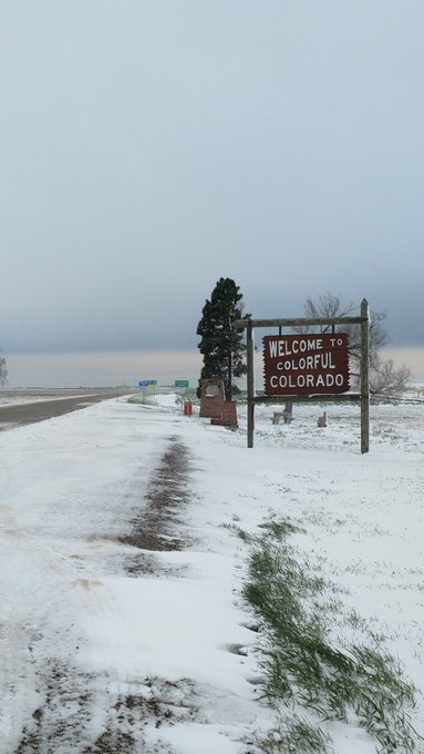
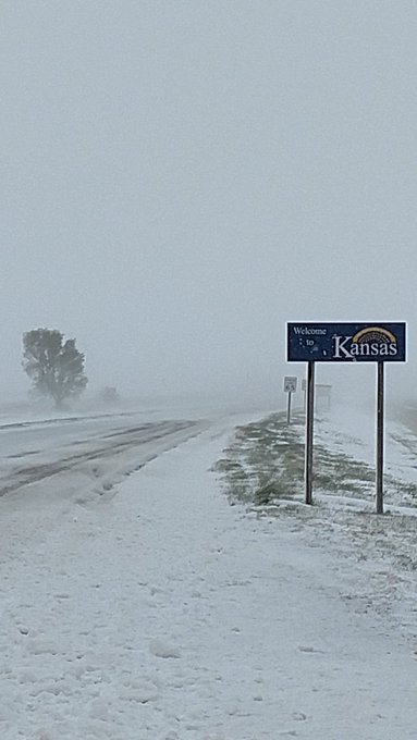
@NWSGoodland The view looking East and West at the state line on Highway 40 is interesting.
Tree damage and power outages may also ensue due to the snow and gusty winds.
"The cold and/or weight of the snow could damage flowers that residents may have already planted," AccuWeather Meteorologist Eric Leister said.
The first day of May could bring school delays or cancellations in the northern Plains.
Children and those young at heart will welcome the snow as one last opportunity to go sledding before summer arrives.
However, do not delay in grabbing your sled. Temperatures will quickly rebound the day after the storm departs, rapidly erasing the snow and winter's revenge.
 

Alabama to Indiana to face severe weather threat into Sunday night

By Renee Duff, AccuWeather meteorologist
April 30,2017, 4:26:31PM,EDT
 
 
For the latest reports on the flooding and severe weather that has already plagued the Central states, please click here.


Severe thunderstorms capable of causing property damage and flooding will continue to target communities from the southeastern United States to the Ohio Valley into Sunday night.
A storm will finally make eastward progress early this week after dumping flooding rainfall and triggering damaging thunderstorms for several days over the Central states.
The storm was responsible for the deadly tornadoes that tore through northeastern Texas late on Saturday.
Sunday severe PM April 30

Into Sunday evening, the most intense thunderstorms will continue to advance across Alabama and into northwestern Georgia. Severe thunderstorms will also erupt across Tennessee during this time.
“With plenty of heat and humidity to tap into, these storms will be capable of producing damaging winds and hail as well as a few tornadoes,” AccuWeather Meteorologist Faith Eherts said.
Tornadoes have already caused damage in central Mississippi on Sunday morning, including in the Natchez area.
Thunderstorms halted play at the PGA's Zurich Classic of New Orleans for six hours.

The thunderstorms will also unleash an abundant amount of rainfall, which can quickly flood side streets and neighborhoods. Blinding downpours will create another danger for motorists.
The danger of severe weather will expand northward into Sunday night.
“While the threat for hail and tornadoes will extend through Alabama and Tennessee this evening, storms rolling through Indiana and Kentucky are expected to be mainly heavy and gusty with pockets of damaging winds,” Eherts said.
Strong winds not far above the ground could be brought down to the surface during any of the thunderstorms, potentially resulting in power outages and tree damage.
RELATED:
Latest severe weather watches and warnings
How to stay safe when severe weather strikes at night
2017 US summer forecast: Early storms to hold back heat in Northeast; Wildfires to rage in California

Residents in Evansville, Indiana; and Louisville, Kentucky, may be kept awake by the potent thunderstorms on Sunday night.
The strong thunderstorms should remain south of downtown Chicago overnight. However, another thorough soaking with embedded thunderstorms is in store after the city picked up nearly 2 inches of rain on Saturday.
“It will be important for residents to keep up to date on local watches and warnings through the night, keeping in mind that access to a storm shelter may become necessary,” Eherts said.
Those who live in flood-prone areas or downstream of rivers that continue to rise after the deluge will need to monitor water levels and be prepared to evacuate in a moment's notice.
Northeast Severe April 30

Heading into the first day of May, the thunderstorms will march eastward toward the central and southern Appalachians.
While the severe weather danger from Sunday will wane by daybreak Monday, thunderstorms could turn severe from Pittsburgh and Erie, Pennsylvania, to Buffalo, New York, and Toronto, Canada, on Monday afternoon.

Northeastern US: May to start with returning warmth, severe storms


By Alex Sosnowski, AccuWeather senior meteorologist
By Kristina Pydynowski, AccuWeather senior meteorologist
April 30,2017, 3:27:30PM,EDT
 
 The temperature roller coaster ride in the northeastern United States will continue on Monday, setting the stage for severe thunderstorms over a part of the region.
Cooler air pressed into the Northeast on Sunday, holding temperatures 15 to 25 degrees below Saturday's highs in many communities.
The change was even more dramatic in Boston. After coming close to breaking Saturday's record high of 85 F, temperatures were about 40 degrees lower on Sunday afternoon.
NE Monday temps
An exception to the cooldown on Sunday was the southern mid-Atlantic and locations along and west of the central Appalachians, where the next warm surge has begun.
Along the boundary separating the warmth and cooler air, spotty thunderstorms will erupt from western Pennsylvania to northern Virginia into early Sunday evening. One or two of the thunderstorms can produce strong wind gusts.
RELATED:
2017 US summer forecast: Early storms to hold back heat in Northeast; Wildfires to rage in California
AccuWeather severe weather center
Northeastern US interactive radar

On Monday, temperatures in much of the mid-Atlantic and central New York will climb into the upper 70s and 80s due to strong southerly winds.
Exceptions to the warmth on Monday include the south-facing shoreline areas and eastern New England due to wind blowing off the cool water. Temperatures will be held to the 40s in Portland and Bangor, Maine.
Northeast Severe April 30
Monday's warmth will occur ahead of another cold front, which will trigger more thunderstorms from the Florida Panhandle to Virginia and western New York. Some of the thunderstorms will become severe with hail and damaging winds. The threat will be greatest along the I-79 and I-81 corridors.
An isolated tornado or two may also touch down, mainly north of Interstate 80.
Cities at risk for the violent thunderstorms include Morgantown, West Virginia; Harrisonburg, Virginia; Pittsburgh and Harrisburg, Pennsylvania; and Buffalo and Rochester, New York.
The thunderstorms may weaken below severe criteria upon reaching the I-95 corridor from Washington, D.C., to New York City on Monday night.
The passage of this front will slash highs by 10 to 20 degrees around the eastern Great Lakes for Tuesday. Highs in the lower to middle 70s will be more common from New York City to Washington, D.C., this day.
Long-range outlook
"We expect more significant cooling to take place during the first weekend and second week of May," according to AccuWeather Lead Long-Range Meteorologist Paul Pastelok.
"We have been getting mixed signals as to the magnitude of the cooling trend before the middle of May, but we suspect temperatures may dip below average a bit for much of the second week, followed by near- to above-average temperatures for much of the second half of the month in the Northeast," Pastelok said.
On one hand, there is a scenario that will bring showers and thunderstorms with hail and chilly air during next weekend. Another scenario would bring another brief wave of cool air followed by a big warmup next weekend.
Pastelok remains concerned about the potential for a chance of a brief frost over parts of the interior Northeast prior to the end of May.
Gardeners may be able to plant warm-season vegetables and annual flowers during the upcoming warmth, provided they have a means to protect their investment should a spell of frosty air come calling before the Memorial Day weekend.

Germany: Rain threatening to spoil May Day festivities after Sunday’s warmup

By Adam Douty, AccuWeather meteorologist
April 30,2017, 12:30:45PM,EDT
 
 
After a dry and mild dry across the country on Sunday, rain and cooler air will return by May Day.
An area of low pressure and cold front diving into western Europe will spread clouds, rain and lower temperatures across western and southern Germany on Monday.
Communities in western Germany from Cologne to Saarbrücken and Frankfurt will have to contend with rain and temperatures some 5-10 degrees C (8-16 degrees F) lower on Monday compared to Sunday.
4/30 Germany

During the afternoon, thundershowers will develop in the wake of morning rain across North Rhine-Westphalia, Rhineland-Palatinate and Saarland. Not only will residents from Trier to Freiburg have to be alert for lightning, a few heavier storms could produce hail.
In Munich, Monday morning may be the better time to visit Auer Dult than the afternoon when the rain is expected to be falling. While temperatures on Monday will be a degree or two lower than on Sunday, highs will still be close to normal for the beginning of May.
Northeastern Germany will enjoy the best weather on May Day as dry weather holds underneath some sunshine.
Residents and visitors in Berlin planning to attend the 5th Berlin Water Sports Festival in Grünau or the Children’s Festival near the Brandenburg Gate will not have to worry about carrying along an umbrella or wearing a heavy jacket.
RELATED:
Germany weather center
AccuWeather Minutecast
Interactive Germany radar

High temperatures across northeastern Germany will be similar or slightly higher than what was seen on Sunday. A gusty wind, however, will still make it feel cool on occasion.
The low pressure system that will provide rain across western and southern Germany on Monday will be slow to exit the region. Showers and near- to below-seasonable temperatures will remain through at least midweek.
 

Central US: More rivers to swell to major or record flood stage this week


By Kristina Pydynowski, AccuWeather senior meteorologist
April 30,2017, 4:29:21PM,EDT
 
 
Despite flooding rain from this weekend departing by Monday, rivers across the central United States will continue to rise and threaten homes and residents this week.
A widespread swath of 4 to 8 inches of rain has inundated communities from Oklahoma to northern Arkansas and the lower Ohio Valley since Friday with locally higher amounts.
One of the highest rainfall totals has been measured in southern Missouri with nearly 10 inches in the community of Houston.
Flash flooding quickly ensued throughout the Central states, leading to road closures and forcing evacuations.
Streams and rivers rapidly rose, and the secondary and major rivers will continue to rise well after the rain has ended and flood waters drain downstream.
Rainfall April 30
“The area was susceptible to major flooding since prior recent heavy rain in much of this swath had the ground saturated and stream and river levels elevated going into the new heavy rain event,” AccuWeather Senior Meteorologist Alex Sosnowski said.
Moderate to major river flooding is expected on the mid-Mississippi, the lowest point of the Ohio, Illinois, Wabash, Black and White rivers.
More record crests are anticipated on smaller rivers in the region. However, even the Mississippi River at Cape Girardeau, Missouri, will approach its record crest of 48.9 feet.
On Saturday night, the North Fork White River near Tecumseh, Missouri, reached its highest level in more than a century. The river rose to 35.51 feet, breaking the previous record crest of 35 feet from Aug. 1, 1915.
River flooding April 30
National Weather Service hydrologists also expect the Current River at Doniphan, Missouri, to shatter its record crest level of 26.8 feet from March 1, 1904. The river should crest close to 40 feet by midweek.
As is typical, it will take longer for the larger rivers to crest.
The mid-Mississippi River will likely not crest until the middle to latter part of this week.
The river at St. Louis may reach major flood levels later this week where Choteau Island Levee, which protects 2,400 acres, is breached. Flooding will begin in Lemay Park, located just south of Lemay Ferry Road.
RELATED:
AccuWeather Severe Weather Center: Flood watches, warnings
Preparing for the costliest weather disaster in the US: How to stay safe before, during and after a flood
Reports: Damaging storms strike southern US after tornadoes kill at least 5

The Mississippi River will crest at near-record levels in Cape Girardeau toward and during next weekend.
South of where the Ohio River flows into the Mississippi, the river should slowly climb through following week.
“Residents and officials in the region should closely monitor the flooding situation and be prepared to take action as waters rise,” Sosnowski said.
Never attempt to walk or drive through flooded areas to avoid a potentially deadly situation. More deaths typically occur each year due to flooding than from any other thunderstorm-related hazard. Only six inches of fast-flowing water can knock over an adult. Only two feet of flowing water is needed to sweep away most vehicles.
Midweek April 30
The rivers will rise early this week despite the return of dry weather. However, the dry spell will not last long.
A new storm will arrive at midweek, spreading soaking rain from Oklahoma to Missouri and the Ohio Valley. A new round of severe weather may erupt over Texas and the lower Mississippi Valley.
More lives and property will be at risk as the downpours from both the rain and thunderstorms threaten to renew flash flooding and bring further rises on area rivers.
 

UK: Rain to threaten outdoor plans during early May bank holiday

By Eric Leister, AccuWeather meteorologist
By Adam Douty, AccuWeather meteorologist
April 30,2017, 12:02:24PM,EDT
 
 
While the recent cold snap has ended, bouts of rain will persist and threaten to disrupt outdoor plans across the United Kingdom during the bank holiday.
A slow-moving depression across Britain will keep most of the United Kingdom unsettled with showery spells on Monday; although, northern areas will have a largely dry day.
Across the south of Britain, some of the showers will turn thundery while it will be a rather cloudy, dull day for many. The best of any sunshine will be seen across northwestern Scotland.
4/30 UK

Residents who are not letting the threat of rain ruin their visit to the National Trust Hatchlands Parkland and walk the Sylvanian Family themed nature trail on May Day will want to wear their wellies and rain gear. Anyone outdoors should be ready to head inside if thunder is heard.
"Showers that [will] move through London on Monday could put a damper on the fun and games set to happen at the Spring Festival at Brent Cross Shopping Centre for a time," AccuWeather Senior Meteorologist Kristina Pydynowski said.
RELATED:
United Kingdom Weather Center
MinuteCast® for your location
Interactive United Kingdom weather radar

"An odd shower turning thundery in southern England cannot be ruled out," she said. "If that happens, carnival rides will have to be briefly halted and anyone outdoors will have to temporarily move indoors."
Despite the threat of showers, high temperatures will generally range between 12 and 15 C (54 and 59 F) across the United Kingdom on Monday, which is within a few degrees of normal for the start of May.
The warmest air across the United Kingdom will be found in western Scotland and Northern Ireland, where some locations away from the coast could reach 17 C (63 F).

Severe thunderstorms to flood Texas to Illinois through Saturday night

By Renee Duff, AccuWeather meteorologist
April 30,2017, 2:54:23AM,EDT
 
 
For the latest reports on the flooding and severe weather that has already plagued the Central states, please click here.


Dangerous thunderstorms and flash flooding will continue to threaten lives and property across the central United States through Saturday night.
Some communities will be rocked by severe weather and flooding for the second consecutive day in a row.
The metro areas of St. Louis; Little Rock, Arkansas; Dallas, Tyler and San Antonio, Texas; and Shreveport, Louisiana, will be blasted by the thunderstorms during the first half of the weekend.
Residents in the above cities and their respective suburbs may contend with canceled or altered outdoor plans. Property damage, power outages and flooding may also occur.
Severe late pm April 29

The thunderstorms will follow the severe weather and flooding rain that started the weekend.
At least two tornadoes left a trail of damage in the Van Zandt and Henderson counties in Eastern Texas Saturday evening. Canton, in Van Zandt County, was hit by a confirmed tornado. Another tornado is believed to have touched down in Eustace, in Henderson County.
Dozens of cars flipped over on I-20 east of Canton, with at least 40 injuries reported.
AccuWeather Senior Meteorologist Frank Strait expects the main concentration of severe weather to center over the Arklatex region into Saturday evening.
Damaging winds up to 70 mph will litter roads and neighborhoods with broken tree limbs and downed power lines. A few tornadoes could also touch down, threatening some communities with far more extensive damage.
RELATED:
Latest severe weather watches and warnings
How to stay safe when severe weather strikes at night
Weekly wrap-up: Dangerous flooding engulfs eastern North Carolina; March for Science draws thousands to rainy DC

Thunderstorms containing these hazards could reach as far north as Cape Girardeau, Missouri, and as far south as San Antonio, Texas.
The violent thunderstorms will sweep eastward and continue to pack a punch as they approach the lower Mississippi Valley during Saturday night.
Sunday severe April 29
“Damaging winds and hail will be the main threats through the overnight hours,” Strait said.
Areas from Illinois to Texas and Louisiana will not only be hit hard by severe weather, but also flooding rainfall.
“These thunderstorms will produce a large amount of rainfall in a short amount of time and will not be moving very quickly,” Strait said.
The thunderstorms could dump several inches of rain in as many hours, which can quickly overwhelm storm drains and cause streams and rivers to rise.
The downpours will renew or worsen flooding issues that inundated southern Missouri and neighboring areas earlier this weekend.
Additional severe weather will fire up across lower Mississippi Valley and points eastward on Sunday.
Communities from Memphis, Tennessee, to Jackson, Mississippi, to New Orleans will be at risk for the potentially damaging thunderstorms.
The greatest risks will be damaging winds and flooding downpours, but the strongest thunderstorms can also produce hail and isolated tornadoes.

Slow-moving storm to douse Hawaii with flooding rain into early May


By Alex Sosnowski, AccuWeather senior meteorologist
April 30,2017, 2:59:03PM,EDT
 
 While a storm will douse outdoor plans and lead to flooding on some of the Hawaiian Islands, enough rain may fall to ease drought conditions into the start of May.
People heading out and about in Hawaii will need waterproof shoes and rain ponchos to handle the widespread wet weather. The rain could spoil some days at the beach.
A storm from the north will continue to impact Hawaii into Monday.
The storm will be more typical of that of the middle of winter, rather than April, according to AccuWeather Meteorologist Maggie Samuhel.
Hawaii April 30 PM

"The storm will produce much more substantial and frequent rainfall when compared to the typical trade wind showers," Samuhel said.
Because of the slow-moving nature of the storm, it could deliver more rainfall to some areas, when compared to a weak, fast-moving tropical storm.
"There is the potential for the Big Island and Maui to receive several inches of rain, especially if the storm lingers into Monday," Samuhel said.
On these islands, areas of flooding and road washouts may occur, including on the sides of the islands that typically experience a rain-shadow effect.
On Saturday, a sinkhole re-opened on the Kaupo side of the Alalele Bridge on Maui.
RELATED:
AccuWeather Severe Weather Center
Mesmerizing lava flows from Hawaii's Kilauea volcano
Firehose of lava flows from Kilauea volcano into the sea

Downpours will also persist across the islands of Lanai, Molokai and Oahu, where some incidents of flash and urban flooding can occur, as well as isolated mudslides.
Farther northwest, on Kauai, rainfall will overall be less intense and not as frequent as that of the middle and southeastern islands in the String of Pearls.
The islands have been experiencing abnormally dry-to-drought conditions since last year, according to the United States Drought Monitor. This is despite being in the proximity of multiple tropical systems in recent years.
The widespread rainfall will also help to alleviate the brush fire risk, at least in the short term.
"The rainfall from the slow-moving non-tropical storm will ease drought conditions in some areas and could completely eradicate it in others," Samuhel said.
The storm will also pull cool air down from aloft.
High temperatures may be held to the 70s F for a few days in Honolulu.
The air can get cold enough to allow snow to fall with accumulations on the summits on the Big Island into Monday. Strong winds will blow and drift the snow around, creating blizzard conditions.
In terms of wind and seas, conditions may not be as rough as that of a tropical storm affecting the area.
However, bathers and boaters should use caution as there may be shifting winds and sudden building surf and seas as the storm unleashes the downpours.
 

Military plane crash in western Cuba kills at least 8


By Kristina Pydynowski, AccuWeather senior meteorologist
April 30,2017, 7:14:10AM,EDT
 
 
At least eight people are dead after a Cuban military plane crashed in western Cuba on Saturday morning.
The plane crashed in the western province of Artemisa, according to the Associated Press.
The AN-26 departed Playa Baracoa airport, located outside Havana, at 6:38 a.m. EDT and crashed into a hillside about 65 kilometers (40 miles) to the southwest, outside the town of Candelaria.
Satellite data indicates scattered cloud cover over western Cuba during the early morning of Saturday, but no lightning was detected in the area around the time of the crash.
RELATED:
Cuba weather center
Cuba interactive satellite
Detailed forecast for Havana, Cuba

Preliminary weather observations from Havana's José Martí International Airport indicates east-southeasterly winds of around 7 mph shortly before 7 a.m. EDT Saturday.
This is a breaking story and AccuWeather will continue to provide updates as they become available.
 

Tornado, Flooding, Golf Ball-Sized Hail as Severe Weather Moves Into Midwest, South

Eric Chaney and Ada Carr
Published: April 26,2017

A tornado touched down about six miles southwest of Adair, Oklahoma, Tuesday night as a line of dangerous severe weather sweeps across the Midwest and South.
According to the National Weather Service, preliminary surveys show damage consistent with an EF1 tornado, but field teams are still surveying the overall track and additional damage. A second possible tornado hit Hughes County.
Parts of the South and Midwest saw impacts Wednesday morning as well. Flooding hit parts of Arkansas and golf ball-sized hail fell in parts of Texas and Oklahoma.
(MORE: Multiple Rounds of Severe Thunderstorms, Including Possible Tornadoes, Through at Least Sunday)
Flooding in northwest Arkansas forced the closure of several streets in Springdale.
(Anna Ranz, Fayetteville, AR)


This line of severe storms stretches from parts of east Texas into Louisiana, eastern Oklahoma, Arkansas and Missouri, and should push into the Lower Ohio Valley southward into west Tennessee and Mississippi and continue in Louisiana Wednesday night.
Tornadoes, occurring in discrete supercells or embedded within the squall line, will be possible throughout the event.
Here are the latest impacts from these storms.

Oklahoma

The EF1 tornado touched down around midnight Tuesday night in Adair, ABC 8 reports, and there were multiple reports of damage in the area.
One family of four told News on 6 they were able to ride out the storm by getting into a closet. They said the winds knocked down their barn and three horses inside escaped into a nearby pasture.
Brittany Perkins told the station neighbors used chainsaws to clear trees from nearby roads and driveways.
In Hughes County, the National Weather Service reported an awning was destroyed and air conditioner units were blown off the roof of a Walmart near Holdenville by a second possible tornado. There were numerous roofs blown off in the area, windows blown out and trees downed in the area, the NWS said.
McIntosh County Emergency Management officials told ABC 8 there were reports of broken windows near Stidham, and half of Checotah and parts of Eufaula were without power Wednesday morning.
Damage from a possible tornado near Holdenville, Oklahoma.
(ABC 8 )
Parts of Oklahoma also saw golf ball-sized hail Wednesday morning. Emergency management officials in LeFlore County reported that several vehicles on the north side of Heavener had body damage and windshields broken.

Illinois

Strong winds downed a tree onto a trailer in Clay Tuesday, according to NWS.

Arkansas 

Flooding has inundated multiple highways, roads and the interstate in Northwest Arkansas around Springdale, KNWA reports. The city has closed nearly half a dozen streets, and city officials are asking residents to avoid driving until the rain stops.
Two people were rescued by Buffalo National River crews Wednesday after being swept away by fast moving water when their canoe turned over in Newton County.
The area has had thunderstorms throughout most of the day, according to weather.com meteorologist Jonathan Belles.
Vehicles became stranded due to flooding near Mabelvale Wednesday.
Entergy Arkansas says more than 16,000 were without power as of Wednesday evening.

Texas

Golf ball-sized hail fell in Mansfield, Duncanville and Cedar Hill as the storm blew through Wednesday morning, NBC Dallas-Fort Worth reports.
According to NBC, both Dallas/Fort Worth International Airport and Dallas Love Field reported ground stops. As of 8:20 a.m., DFW reported departure delays of an hour or less. Love Field reported delays lasting at least an hour.
MORE: What's Your Tornado Risk in Any Given Month?

The Weather Company’s primary journalistic mission is to report on breaking weather news, the environment and the importance of science to our lives. This story does not necessarily represent the position of our parent company, IBM.

Above-Average Tornado Activity Doesn't Necessarily Mean Much for Climatological Peak of Tornado Season, History Shows

Jonathan Belles
Published: April 27,2017

With a few days left in April, the first four months of 2017 are off to a quick start for tornado activity in the United States.
Tornadoes occur when the right conditions line up in the atmosphere. Meteorologists usually look for certain patterns that can bring severe weather – including tornadoes – and these patterns often come and go over periods of weeks or months.
Therefore, this early-year activity doesn't conclusively say anything about the number of tornadoes we'll see in May or the rest of the year, NOAA says.
The number of weather systems that will feed on favorable ingredients beyond a week into the future is hard to forecast, but one thing is for sure: there will be tornadoes in May. How many? Stay tuned; there have been more than usual so far this year.
(MORE: Tornado Central | Your 7-Day Severe Weather Outlook)

Very Busy Start for Tornadoes

Preliminary tornado reports through Tuesday remain above the 10-year average from 2005 to 2015 with nearly 500. According to NOAA, 2017 is already more than halfway to the seasonal total of 2016 which was a below-average tornado year with 971 total.
Preliminary tornado reports Jan. 1-April 23, 2017.
(Storm Prediction Center/NOAA)
Usually, during the winter months, the warmth and needed moisture are capped to the Gulf Coast states. This year, favorable winds aloft and at the surface brought the unseasonably favorable conditions northward – sometimes as far as the Midwest.
(MORE: U.S. Warm Records Crushing Cold Records by Over 5-to-1 Ratio)
The above-average temperatures that started 2017 likely contributed to the higher-than-average tornado counts in the first four months of the year.
The number of reports is usually filtered and condensed by the Storm Prediction Center (SPC) to get a more accurate count. Often, multiple people will report a single tornado, and these reports are all added to the list of local storm reports (LSR's). The actual number of tornadoes is usually less than the tornado reports.
Tornado count and percentiles from 1954 to April 25, 2017. Data is preliminary for 2017.
(Storm Prediction Center)
Although tornado counts are still being filtered and verified, the number of actual tornadoes is approaching 500 through Tuesday, which is near a record for most tornadoes to-date since 1954. This number of actual tornadoes has flirted with or surpassed record levels to date since the beginning of March.
2017 would be the first time since records began in 1950 with the first four months topping 100 tornadoes in the U.S., according to Steve Bowen, director of impact forecasting at the reinsurance company Aon Benfield.
It is important to note tornado counts have been, at least in part, artificially growing since 1950 due to the rise of storm spotters and social media – especially in the last couple decades.

May is the Peak of Tornado Activity

Although there is no defined tornado season in the U.S. since tornadoes occur year-round, tornado activity peaks in the late spring.
(MORE: Tornado Risk by Month)
"Tornado season" occurs whenever the best recipe for severe weather ingredients comes together in a given location. For communities farther north, tornado season is shorter and occurs when temperatures are generally warmer. To the south, this season can be year-round.
May is the peak month for tornado activity with an average of 276 twisters during the 20-year period spanning 1996-2015. June is second with 217 tornadoes, on average.

The 1991-2015 average number of May tornadoes in the U.S. is 269, according to USTornadoes.com.
During May, activity shifts from what is typically marked as Dixie Alley in the South to the Plains' Tornado Alley. This is typically where low-pressure systems are greeted with an abundance of moisture from the Gulf of Mexico and plenty of heat to kick off storms.
According to the SPC, May owns five of the top 10 most damaging tornadoes in terms of inflation-adjusted damage:
(MORE: The Most Tornado-Prone Locations in the U.S.)
According to Dr. Greg Forbes, severe weather expert at The Weather Channel, four of the top 10 tornado outbreaks have also occurred in May:
These outbreaks are ranked using 11 parameters combined into a "Forbes Impact Index."
MORE: Plains Severe Flooding, Tornadoes, May 24 - June 3, 2016

The Weather Company’s primary journalistic mission is to report on breaking weather news, the environment and the importance of science to our lives. This story does not necessarily represent the position of our parent company, IBM.

Flooding Was Nearly Three Times Deadlier Than Tornadoes and Lightning Combined in 2015-16, NOAA Says

Brian Donegan
Published: April 27,2017

Flooding was extremely deadly in the United States over the past two years, claiming many more lives than tornadoes and lightning combined.
From January 2015 through December 2016, 302 people were killed by floodwaters, while 65 deaths were caused by lightning and 53 were the result of tornadoes, according to NOAA statistics.
Of the 126 flood deaths in 2016 alone, the highest number occurred in Texas, with 38. This was followed by 24 fatalities in West Virginia – 23 from a flash flood in June – and 20 deaths in North Carolina, all from Hurricane Matthew's record flooding in October.
(MORE: Hurricane Matthew Recap)
In this photo released by The Weather Channel, a vehicle rests in a stream after a flooding rain event near White Sulphur Springs, West Virginia, Friday, June 24, 2016.
(Justin Michaels/The Weather Channel via AP)
In 2015, the 176 flood deaths in 26 states were the most since 1995, according to NOAA.
The 302 lives lost in flooding from 2015 through 2016 was almost three times as many deaths than we saw from tornadoes and lightning combined in that same period – 118.
For comparison, there are typically about 82 flood deaths a year; flooding is, on average, the second-deadliest weather-related event in the U.S. behind extreme heat.
Since 1995, the number of flood deaths annually has ranged from a low of 29 in 2012 to as many as 176 in 2015. The second-deadliest year was 1998, when 136 were killed.
Only heat has caused more deaths than flooding on an annual basis during the last 30 years (1986-2015).
(NOAA)
With regards to yearly rainfall, studies have shown climate change may increase the risk of heavy rain around the world. According to a 2016 study, the number of days with extremely heavy precipitation has increased 1 to 2 percent every decade in both typically wet and dry locations.
(MORE: Warming Brings Increasing Flood Risk and Heavier Rain)

Vehicles and Floodwaters Are a Dangerous and Deadly Combination

Vehicles have been involved in a large number of flood deaths over the years.
In 2015, about 64 percent (112 out of 176) of flood deaths involved vehicles. Many of those likely occurred when people attempted to cross a flooded road, NOAA said.
Vehicles were also a part of many flood-related fatalities in 2016. As an example, many of the 20 deaths in North Carolina from Hurricane Matthew involved motorists swept away on flooded roads.
If there is one thing to take away from reading this article, it is that you should never attempt to drive through floodwaters.
(MORE: In Flash Flooding, Your Vehicle Can Be Your Biggest Danger)
It's easy to misjudge the depth of floodwater, particularly at night. Sometimes the bridge or road masked by flood water may have been undermined or completely washed out.
According to FEMA:
  • Six inches of water will reach the bottom of most passenger cars, causing loss of control and potential stalling.
  • One foot of water will float many vehicles.
  • Two feet of rushing water will carry away most vehicles, including SUVs and pickups.
Vehicles are left stranded on Texas State Highway 288 in Houston, Texas, May 26, 2015.
(Aaron M. Sprecher/AFP/Getty Images)
A note about this report:
For 2015, we used the deaths in NOAA's flood hazard report. Deaths in 2016 were compiled using NOAA's storm data and local storm reports from the National Weather Service. It is possible there have been other flood-related deaths in 2016 not uncovered in our thorough search.

Second Death Confirmed in North Carolina Flooding

Jon Erdman and Pam Wright
Published: April 27,2017

A Florida woman, who went around a barricade on a flooded North Carolina road, was found dead Thursday in her car as flooding triggered by torrential rain continued to plague the state.
According to the Associated Press, Sandra Berry, 65, of Kissimmee, Florida, died Wednesday night after her car was swept off N.C. 58 in Greene County. Highway Patrol Sgt. Michael Baker said Berry drove around barricades put up to keep vehicles off the flooded highway. Firefighters found her body after someone spotted her car in the water.
Meanwhile, a state of emergency was declared in Edgecombe County on Wednesday. A shelter was opened for those forced to flee their homes because of the flooding.
Estimated rainfall (contours) and reports of flooding (blue dots) in North Carolina in the 24-hour period ending 6:30 a.m. EDT, April 25, 2017.
As floodwaters began to recede in the capital, the Neuse and Tar river levels rose further downstream and are in major flood stages in some areas. They will continue to do so into the weekend, said weather.com meteorologist Chris Dolce.
(MORE: Your Vehicle Can Be Deadly in a Flash Flood)
State department of Transportation spokesperson Robert Broome said Tuesday that an unidentified body was discovered by a maintenance crew removing debris at a bridge over the Neuse River. Authorities say it is unclear if the death is weather related. On Thursday, authorities had yet to identify the body.
Among the hardest-hit areas was Crabtree Creek north of downtown Raleigh, which rose over 17 feet in 24 hours since Monday morning at Old Wake Forest Road, topping levels at which water enters businesses and homes in the area, and just over 2 feet below its record crest before leveling off.
Floodwaters swamped parking lots at Crabtree Valley Mall, which did not open as scheduled Tuesday.
Gov. Roy Cooper said Tuesday that "we’ve seen rainfall like we haven’t seen since Hurricane Matthew."

A band of heavy rain intensified and focused in parts of central and eastern North Carolina overnight Monday into early Tuesday. A few locations picked up more than 8 inches of rain since Monday morning, reports the NWS.

Record-Breaking April Rain

In fact, the calendar-day rainfall at Raleigh-Durham International Airport on April 24 set an all-time April record, in 130 years of records, and helped set the city's wettest April record, which had stood since 1895. April is typically the city's driest month, averaging just less than 3 inches for the entire month.
These 8-inch-plus rain totals exceeded those measured in the Raleigh metro area during Hurricane Matthew in early October 2016, though much heavier rain fell in southern North Carolina southward during Matthew.
MORE: Severe Weather in the Midwest, Great Lakes April 10, 2017

The Weather Company’s primary journalistic mission is to report on breaking weather news, the environment and the importance of science to our lives. This story does not necessarily represent the position of our parent company, IBM.

Severe Storms Hit the South; Damage Confirmed in Alabama, Georgia

Sean Breslin
Published: April 27,2017

Severe storms hit parts of southern Alabama and Georgia Thursday, and at least two confirmed tornadoes left damage in the South.
Meteorologists with the National Weather Service said a tornado was in progress in Pike County, Alabama, just a few minutes before 11:30 a.m. CDT Thursday morning. The twister had a debris signature on radar, and multiple reports of damage were found in the same area, the NWS also said.
Between the towns of Troy and Banks, a mobile home was flipped by the storm, according to the Troy Messenger. It was only unoccupied because the owner of the home, Rubie Townsend, was at the Troy Nutrition Center when the tornado hit, the report added.
"I thank the Lord," she told the Messenger. "I didn’t go yesterday and thought about not going today, but I got up and went."
(MORE: Severe Weather Threat Continues into the Weekend)
The county's emergency management agency said the damage path spanned half a mile. Downed trees damaged several homes, and power lines were also brought down by the powerful storm.
No injuries were reported in the area, but Pike County EMA spokeswoman Jeanna Barnes told the Associated Press rescuers had a pull a man from his house after he was trapped by a downed tree.

Damage Confirmed in Georgia, Mississippi

A few hours later, another tornado debris signature was spotted on radar, but this time, it was in southern Georgia. The storm tracked just north of Junction City in Talbot County, where structural damage was left behind.
In addition to the damage, one woman was treated for minor injuries after getting trapped in a home near Baldwinville, according to an NWS report. It was one of two homes to sustain damage in the area.
In Mississippi, the NWS confirmed an EF1 tornado hit the north side of Walnut Grove Wednesday night. The twister was in progress for more than 10 miles and left several homes with roof and siding damage, according to the damage survey performed by the NWS on Thursday.
The storms came six years to the day after one of the worst tornado outbreaks in U.S. history ravaged the South on April 27, 2011. More than 300 people died in the event that claimed at least $10 billion in damage.
MORE: Tornadoes Hit the South in January

The Weather Company’s primary journalistic mission is to report on breaking weather news, the environment and the importance of science to our lives. This story does not necessarily represent the position of our parent company, IBM.

Hiker Lost in Snowstorm on Nepal Mountain Rescued After 47 Days

Andrew McFarlane
Published: April 28,2017

After a perilous 47 days stranded on a mountain in Nepal with only salt and water to survive on, a Taiwanese man was rescued Wednesday. His girlfriend had died just three days before his rescue.
Liang Shen Yueh, who turned 21 on Friday, told the Associated Press he and his girlfriend, 19-year-old Liu Chen Chun, where hiking the Ganesh Himal Trail when a snowstorm caused them to go off course.
Without a guide, the two followed a river in hopes of finding a village before falling over a waterfall. The couple then landed on a rocky ledge beneath the falls, where they were unable to climb up or down, said Madhav Basnet, an official with the Asian Trekking agency.
The couple used the food they had in their backpacks for the first two weeks but had to rely on just salt and water to survive once they ran out of food.
Rescue crews scoured the area for two weeks after the couple was reported missing, but then had to suspend their search. Crews resumed the search April 20.
On Wednesday, rescuers caught glimpse of the couple’s red tent stranded on a ledge beneath the waterfall and climbed down to them.
"We found the man alive and able to speak to us, but the woman was already dead. We could not carry them so we called a helicopter,"said Basnet.
(WATCH: Pilot Makes Smooth Emergency Landing)
Rescuers transported both Liang and the body of his girlfriend to Nepal’s capital city of Kathmandu. He was checked into  Grande Hospital, where, despite losing 66 pounds and being extremely exhausted, he appeared to be in good health.
"He was suffering from severe malnutrition. His foot was covered with maggots and hair full of lice,” Ajay Singh Thapa, a doctor at the hospital, told the Associated Press. “Despite having to live like that for 47 days, he appears to be mostly normal.”
MORE: Nepal Reopens World Heritage Sites After Earthquake


The Weather Company’s primary journalistic mission is to report on breaking weather news, the environment and the importance of science to our lives. This story does not necessarily represent the position of our parent company, IBM.

April to End With Rockies, High Plains Snow; Upper Midwest Says, "Same," for May Day

Jon Erdman
Published: April 28,2017

Never mind April is wrapping up. Yet more snow is blanketing the Rockies, and will spread into parts of the Plains and Upper Midwest this weekend and early next week.
(MORE: Winter Storm Central)
Winter storm watches and warnings have been posted in the Rockies and High Plains from southern Montana to northeast New Mexico and parts of the Oklahoma and Texas panhandles. This includes the foothills west of Denver and the Palmer Divide south of the Mile High City.

Current Winter Alerts
Already, snow, heavy in spots, is blanketing much of Wyoming, and rain has changed to wet snow in the western Nebraska panhandle.
(INTERACTIVE: Your Current Radar)

Current Radar, Temperatures, Conditions
From Wednesday through Thursday night, Jackson Hole, Wyoming, has measured 21 to 23 inches of snow. Early Friday, up to 2-foot drifts of snow were reported in some areas of Rawlins, Wyoming.

Rockies Forecast

The culprit for this is a sharpening southward plunge of the polar jet stream, carving itself out over the Great Basin and Rockies, then getting kicked into the Plains and upper Midwest this weekend.
By late Friday, a changeover to snow should occur as colder air spills south into the Front Range and eastern Plains of Colorado, western Kansas and northeast New Mexico.

Friday Night's Forecast
Saturday, snow, heavy in spots, will continue in the High Plains of Colorado, far western Kansas and northeast New Mexico. At least some snow is also expected to spread into parts of the Oklahoma and Texas panhandles by Saturday night.

Saturday's Forecast
At least some wet snow is likely to persist from western Kansas into the Texas and Oklahoma panhandles early Sunday.
The heaviest snow totals through Sunday will likely be in the higher elevations of far southern Montana, Wyoming and Colorado. At least 6 inches of wet snow are also possible in parts of the adjacent Plains of Wyoming, western Nebraska, eastern Colorado, far western Kansas, northeast New Mexico and parts of the Oklahoma and far north Texas panhandles.
(MORE: Where April is Typically the Snowiest Month)

Snowfall Forecast Through Sunday
The city of Denver should manage several slushy inches of accumulation, particularly on grassy areas, with less accumulation on roads. The foothills and Palmer Divide will likely see heavier accumulations.
Travel along parts of Interstate 25 in Wyoming, from south of Denver to north of Colorado Springs, and south of Walsenburg, Colorado, to Raton Pass, may become difficult. Interstate 90 in northern Wyoming, a stretch of which was shut down earlier in the week, may also become impassable or may close.
Strong north winds, combined with accumulating wet snow, may lead to some downed trees, tree limbs and power outages in areas of heaviest accumulation.
Incidentally, this could be the fourth-latest measurable snowfall on record in Amarillo, Texas, in 86 years of snowfall records, there.

Upper Midwest Phase Late Sunday Into Monday

There's another phase to this system in the Upper Midwest beginning later this weekend.
With low pressure scooting north toward the Great Lakes and intensifying by Sunday, the air will likely become just cold enough on the low's western flank for a swath of wet snow in parts of the northern Plains and Upper Midwest Sunday into Monday – yes, that would be May 1.
(FORECAST: 7-Day U.S. Rain/Snow Maps)

Upper Midwest Snow Setup
This system should wring out accumulating snow from Nebraska, into eastern South Dakota, western and northern Minnesota. We can't rule out parts of that swath seeing heavy snow accumulations from later Sunday into Monday.
(FORECAST: Sioux Falls, South Dakota | Twin Cities | Duluth, Minnesota)

Upper Midwest Snow Outlook
In addition, strong winds with the intensifying low, combined with accumulating wet snow, may lead to some tree, power line damage and outages in this area.
(INTERACTIVE: When the Last Snow of Spring Typically Falls Where You Live)
Be sure to check back frequently for the latest updates on this upcoming snow event.
MORE: 50 States' Biggest Snow Days

The Weather Company’s primary journalistic mission is to report on breaking weather news, the environment and the importance of science to our lives. This story does not necessarily represent the position of our parent company, IBM.

May 2017 Temperature Outlook: Cooler in Parts of North, West; South Staying Warm

Linda Lam
Published: April 28,2017

The persistently warm pattern in place for much of the U.S. since last summer is expected to continue in some areas into May, while other parts of the country will see a significant change, according to the most recent outlook by The Weather Company, an IBM Business.
(MORE: Pattern Change Will Start May)
Cooler-than-average temperatures have been confined primarily to the Pacific Northwest over the past several months, but in May a larger expanse of cool conditions will stretch from portions of the Rockies into the northern and central Plains and Upper Midwest. Areas near the Great Lakes will likely be near to slightly below average.
Southern Texas along the Gulf Coast into southern Georgia and Florida will likely see temperatures the greatest above average. New England, as well as the South and the West Coast will see temperatures near to slightly warmer than average.
(MAPS: 10-Day Forecast)
May 2017 temperature outlook.
A strong negative North Atlantic Oscillation (NAO) is predicted in early May is one of the factors that will prompting this change. The NAO is an index that reflects pressure differences which influences the position and intensity of the jet stream, which corresponds to different temperature patterns.
"As has been the case most years during the last decade, we expect the negative NAO pattern to rise from the ashes during May and produce more widespread below-normal temperatures across the northern U.S. Because of this hypothesis, supported by numerical and statistical guidance, we have made significant cooler changes for May across the entire northern U.S.," said Dr. Todd Crawford, chief meteorologist with The Weather Company.
(MORE: When You Can Expect Your First 80- and 90-Degree Temperatures)
The record low amount of Arctic sea ice may play a role in this upcoming pattern shift. Crawford believes that the historically low Arctic sea ice values have driven the persistently negative NAO pattern in the summers since 2007.
In addition, the impact of La Niña on the atmosphere is expected to continue to lessen through May, which will likely help to allow warmer temperatures to slowly develop in the Pacific Northwest. Even though La Niña officially ended in February, its influences in the atmosphere have lingered.
(MORE: El Niño May Develop in Late 2017

Average May Highs
For many locations where below-average temperatures are anticipated, average highs are typically in the 60s for May and average lows are in the 30s and 40s. This may mean many areas will have to wait a little longer to put the jackets away or to plant flowers.
(MAPS: Average High and Low Temperatures)
This could also result in summer-like heat for areas of the South, where average highs are already in the 80s and lows are in the 60s in May.
However, this cooler outlook for May does not mean that a generally cool summer is ahead. Additional factors, such as a developing El Niño, may influence temperatures this summer.
(MORE: Summer 2017 Temperature Outlook)
MORE: Tornado Risk By Month 

The Weather Company’s primary journalistic mission is to report on breaking weather news, the environment and the importance of science to our lives. This story does not necessarily represent the position of our parent company, IBM.