The threat for flooding rainfall and strong to severe thunderstorms will continue to spread east through Monday night. This stormy weather will affect a swath from the Ohio Valley and mid-South regions into the central Appalachians and mid-Atlantic, including water-logged West Virginia.
Scattered severe thunderstorms are also possible Monday. The main threats from any storms that do turn severe are damaging wind gusts and hail, though an isolated tornado cannot be ruled out.
NOAA's Storm Prediction Center has issued the following severe weather watches:
- A severe thunderstorm watch until 9 p.m. EDT for parts of northern Tennessee, central/eastern Kentucky, southern West Virginia, and extreme southwest Virginia. This watch includes Nashville, Tennessee, Charleston, West Virginia, and Lexington, Kentucky.
- A severe thunderstorm watch until 10 p.m. CDT for parts of northwest Minnesota, central and eastern North Dakota and northern South Dakota. This watch includes Fargo, North Dakota.
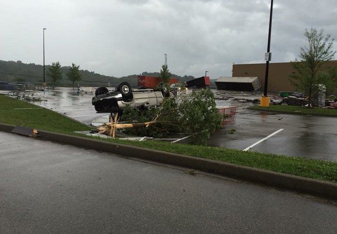
Eastern KY not long ago.... yikes!
This was at a Wal-Mart in Louisa, KY. #kywx
This was at a Wal-Mart in Louisa, KY. #kywx
(LATEST NEWS: Possible Tornado Strikes Louisa, Kentucky)
The National Weather Service has also hoisted flash flood watches from parts of the Ohio Valley into the central Appalachians, as well as in central and southern New Jersey, southeast Pennsylvania, northern Delaware and northeast Maryland.
Flooding was reported over the weekend in parts of Missouri, Kansas, Kentucky and southern Indiana from this same weather system. The National Weather Service reported that water entered some homes in Murray, Kentucky, late Sunday. In Urbana, Missouri, a small truck was washed off a low water bridge late Sunday night, though the occupant was not injured.
(LATEST NEWS: Flooding Strikes the Plains, Midwest)

Current Radar with Watches and Warnings

Heavy Rain and Flooding Forecast
On the Fourth of July, the flood threat, unfortunately, spreads into the mid-Atlantic and Appalachians, including West Virginia. This situation will need to be monitored closely after the third-deadliest flood event in West Virginia's history last month.Pockets of heavy rain will also drench parts of the Ohio Valley and mid-South regions.
Overall, rainfall totals of 1-3 inches are expected, though there could be some higher spots of 3-5 inches.
(MORE: The Most Extreme Rainfall in All 50 States)

Rainfall Forecast

Current Flood Alerts
Since this is a holiday, travelers should be aware that flooding is a serious concern.
(MORE: At Least 234 People Have Been Killed By Flooding in the U.S. in Nearly 18 Months)
According to FEMA:
- 6 inches of water will reach the bottom of most passenger cars, causing loss of control and potential stalling.
- 1 foot of water will float many vehicles.
- 2 feet of rushing water will carry away most vehicles, including SUVs and pickups.
(MORE: Your Vehicle Can Be a Deadly Trap in a Flash Flood
Severe Thunderstorm Forecast
Below are the specifics on where severe thunderstorms will be a threat into Tuesday.Monday Evening
- Forecast: Scattered severe storms are possible from parts of Virginia and North Carolina westward into the Ohio Valley and mid-South. A separate area of severe storms may develop in northern Minnesota and eastern North Dakota.
- Threats: Damaging wind gusts and hail, though an isolated tornado cannot be ruled out.
- Cities: Charleston, West Virginia | Cincinnati, Ohio | Louisville, Kentucky | Raleigh, North Carolina

Monday's Thunderstorm Forecast
- Forecast: A new weather system will bring scattered severe storms to the Upper Midwest, mainly across Minnesota and the eastern Dakotas.
- Threats: Damaging wind gusts and hail, though an isolated tornado cannot be ruled out.
- Cities: Minneapolis | Duluth, Minnesota | Fargo, North Dakota

Tuesday's Thunderstorm Forecast

Tuesday's Thunderstorm Forecast
Flood and Severe Weather Reports This Weekend
A tornado spotted in Oklahoma on Sunday afternoon reportedly caused damage near Stillwater, Oklahoma. Meanwhile, near Solano, New Mexico, strong winds and hail caused heavy damage to a house, including busted windows.Saturday night, flash flooding was reported in the Wichita, Kansas, metro area. The fire department responded to numerous stalled out vehicles in the area. Other parts of Kansas and neighboring Missouri have also seen some road flooding.


No comments:
Post a Comment