Super Typhoon Nepartak appears to have reached its peak intensity as a Category 5 equivalent tropical cyclone, and poses a dangerous threat to Taiwan, Japan's southwest Ryukyu Islands, and eastern China.
Taiwan's Central Weather Bureau issued typhoon warnings Wednesday for a large part of Taiwan, including the islands of Lanyu and Ludao.
(MORE: Taiwan Prepares For Direct Hit)
Nepartak became even stronger Wednesday, packing maximum estimated sustained winds of 175 mph as of early Wednesday morning, becoming the strongest typhoon since Super Typhoon Souldelor in August 2015.

Latest on Nepartak
Tropical cyclones of this intensity are much more common in the western Pacific basin than the Atlantic or eastern Pacific basins, but, for perspective, these central pressures are roughly on par with the peak intensities of Hurricane Camille (900 mb) and Hurricane Katrina (902 mb).
Late Wednesday morning, microwave satellite imagery detected a pair of concentric eyewalls, indicating Nepartak was undergoing an eyewall replacement cycle. When this happens, it's intensity levels off as the outer eyewall cuts off inflow to the inner eyewall, eventually collapsing inward and replacing it.
(MORE: Satellite Images Show Nepartak's Power)
Nepartak exploded from a tropical storm on July 4 to a Category 5 equivalent super typhoon the following afternoon.
Forecast
While Nepartak may have reached its peak intensity, it is running out of time to weaken appreciably before impact in Taiwan.
Nepartak
will continue moving west-northwest, and is now likely to landfall in
Taiwan overnight Thursday night or early Friday, local time (Taiwan is
12 hours ahead of U.S. Eastern daylight time), likely as either a Category 4 or 5 equivalent typhoon.

Projected Path for Nepartak
Conditions
will begin deteriorating along the eastern coast of Taiwan by Thursday
afternoon and evening, local time. Battering waves, some coastal water
rise, outer bands of locally heavy rain and gusty winds should will kick
in by that time.
With now a farther south track, this puts a bigger chance of eyewall winds affecting the capital city of Taipei Friday,
with the potential of numerous power outages, damaging winds,
particularly to any poorly-built structures, and downed trees.
Typhoon Soudelor last August triggered the largest power outage event in Taipower's history, leaving 3.6 million customers in the dark.
Despite
the typhoon's intensity, arguably the bigger threat in Taiwan, as with
most of their tropical cyclones, is from potentially deadly flash
flooding, mud and rockslides, as heavy rains pummel the mountains of the
island.
Last August, Soudelor produced over a foot of rain in Taipei, and over 50 inches of rain in a mountainous location in northern Taiwan.
The
heaviest rain is expected along and to the north and east of Nepartak's
track from Taiwan and the southwest Ryukyu Islands of Japan into
eastern China.

Rainfall Forecast
As
often occurs with tropical cyclones that make a northwest turn in this
region, a second swath of overrunning heavy rain may also develop over
parts of southwest Japan, including Okinawa's Kadena Air Base, which may
also trigger flash flooding.
Due to considerable
land interaction with Taiwan's terrain, Nepartak is excpected to have
weakened considerably by the time it makes its final landfall in eastern
China.
That
said, more locally heavy rain may aggravate any ongoing flooding and
trigger additional areas of flash flooding in eastern China this
weekend.
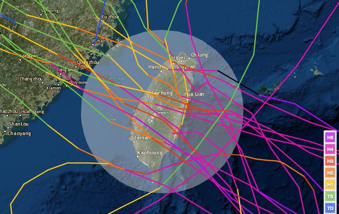
In reliable records dating to 1971, 18 Category 4 or stronger equivalent typhoons have tracked near or over Taiwan (within 125 nautical miles of the center of the island).
NOAA's historical #hurricane tracks: Only 18 Cat. 4+ equiv. #typhoons within 125 nm of central #Taiwan 1971-2015.
Record Long Streak For Western North Pacific Ends
Prior to Nepartak's formation, not a single tropical storm, much less a typhoon (the term for a hurricane in the western North Pacific Basin), had formed west of the international date line since mid-December 2015. Typically this area is the world's busiest tropical cyclone corridor.This set a new record for the longest stretch without at least a single tropical storm in the western North Pacific basin in 66 years of records, according to Colorado State University tropical scientist Dr. Phil Klotzbach.
| Start, End Dates | Consecutive Days |
|---|---|
| Dec. 17, 2015 - July 3, 2016 | 200 |
| Dec. 15, 1972 - June 30, 1973 | 198 |
| Dec. 22, 1997 - July 7, 1998 | 198 |
By the end of June 2015, there had already been nine tropical cyclones in the northwest Pacific basin, including three super typhoons of Category 5 equivalent intensity.
Klotzbach also said Nepartak was the second latest first named northwest Pacific storm of the season on record, behind the record-late July 8, 1998's Tropical Storm Nichole.


No comments:
Post a Comment