Multiple rounds of severe thunderstorms will hit the Midwest and East this week along a frontal boundary that will be draped across those regions. Damaging wind gusts and large hail are the main threats each day, though the chance of isolated tornadoes cannot be ruled out.
A higher-end severe weather threat could materialize in the Midwest on Wednesday as low pressure pushes east along the front while being accompanied by a mid-level atmospheric disturbance. As a result, there may be a corridor of widespread wind damage aligned roughly from Iowa to Illinois, Indiana and Ohio.
Derechos sometimes develop in the type of atmospheric setup taking shape midweek, though it remains to be seen whether one of those will develop Wednesday or not. Derechos are long-lived and widespread wind damage events.
(MORE: What is a Derecho?)

Current Radar with Watches and Warnings

Below is our latest forecast thinking on the timing and magnitude of the severe threats through Thursday.
Severe Weather Forecast
Monday- Forecast: Scattered strong to severe thunderstorms can be expected from western New York, northwestern Pennsylvania, Ohio and southeastern Michigan westward across Indiana, central Illinois, northern Missouri, southern Iowa into eastern Nebraska
- Threats: Damaging winds, large hail and locally heavy rain. An isolated tornado also cannot be ruled out.
- Cities: Buffalo | Cleveland | Detroit | Indianapolis

Monday's Thunderstorm Forecast
- Forecast: Along the stalling west to east aligned cold front, scattered strong to severe thunderstorms are likely to develop from parts of the mid-Mississippi and Ohio Valleys into the mid-Atlantic.
- Threats: The main threats are damaging winds and large hail. Locally heavy rain and isolated tornadoes are also possible.
- Cities: Lexington, Kentucky | Charleston, West Virginia | Washington D.C. | Richmond, Virginia

Tuesday's Thunderstorm Forecast
- Forecast: Severe thunderstorms will develop along a warm front in portions of the Midwest and Ohio Valley. Widespread wind damage is possible from Iowa to Ohio, including the potential for a derecho.
- Threats: Damaging winds, large hail and a few tornadoes are the primary threats.
- Cities: Chicago | Indianapolis | Cincinnati | Louisville

Wednesday's Thunderstorm Forecast
- Forecast: Severe thunderstorms may continue along the front from the Ohio Valley into the central Appalachians and mid-Atlantic.
- Threats: Damaging winds, large hail and a few tornadoes are the primary threats.
- Cities: Cincinnati | Charleston, West Virginia | Richmond, Virginia | Washington D.C. |

Thursday's Thunderstorm Forecast
Storm Reports This Past Weekend
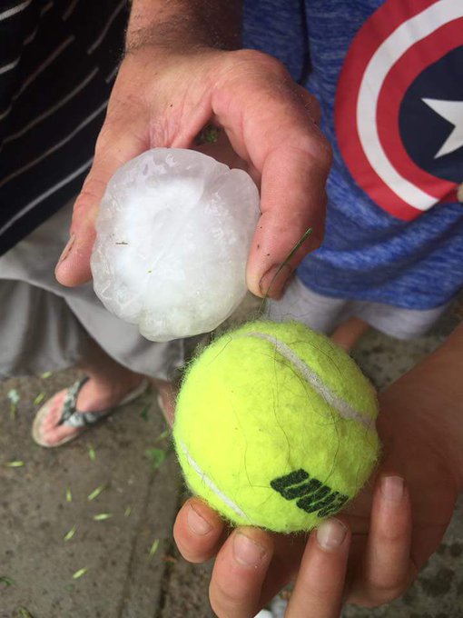
Hail as large as tennis balls, teacups and even grapefruits struck Minnesota Sunday evening as severe thunderstorms rolled through the state.
Tennis ball sized hail from Rosie Nordby, Pequot Lakes earlier. Rotation now north of Deerwood, W of Aitkin @MyFOX9
(LATEST NEWS: Injuries Reported in Minnesota Storms)
The same cold front brought severe weather to northeast Montana on Saturday. Hailstones up to 4 inches in diameter were reported in Wolf Point. A few locations measured wind gusts in excess of 70 mph.
Snapped An Awesome Shot? Share Your Photo!
If you crave pictures of severe weather, you've found your home here. Upload your photos or video (taking care to only take photos and videos from a safe location) to us and share your experience!(PHOTO/VIDEO GALLERIES: Severe | Storms)
PHOTOS: Plains, Midwest Mid-June 2016 Severe Weather and Flooding


No comments:
Post a Comment