A parade of Pacific storms that began last week will continue to impact the Northwest into the coming weekend.
The combined effect of heavy rain and saturated ground may trigger localized flooding in parts of western Washington and western Oregon, and feet of snow will pile up in the Cascades, and other mountain chains from this Pacific onslaught.
Record rainfall has already brought flooding to the Portland, Oregon area to start the work week and the risk of flooding will continue into Thursday.
(MORE: Pacific Northwest Impacted By Flooding)
Western Radar
Monday's Storm
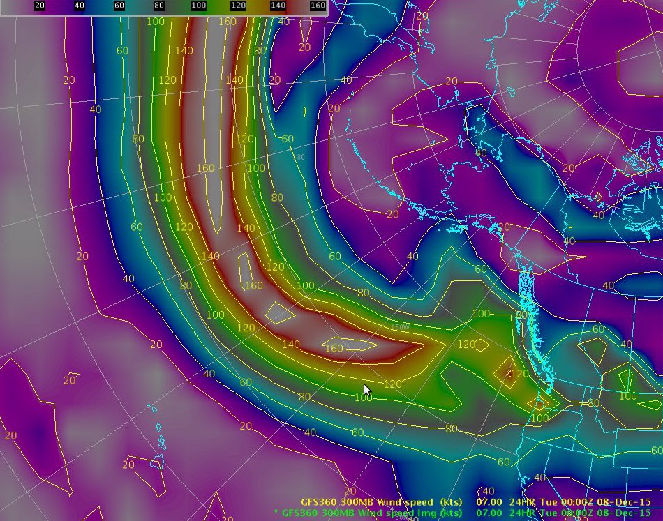
A classic November-December setup featuring a powerful jet stream stretching from eastern Asia across the Pacific for 5,000 miles to the Pacific Northwest will act as the conductor for this storm parade ahead.In fact, winds at jet-stream level over parts of the North Pacific well west of the U.S. were estimated at over 200 miles per hour Friday morning. Talk about a quick flight from Tokyo to Seattle, albeit just a wee bit choppy.
At least one weather system per day this week. The cause? Jet stream screaming across the Pacific at 190+ mph. #wawx
NOAA's National Weather Service (NWS) has issued high wind warnings that are in effect into Tuesday for parts of the western Washington. Wind gusts up to 60 mph are possible at times here.
Wind advisories are in place from Everett, Washington north to the Bellingham area for gusts up to 50 mph on Tuesday.
(FORECAST: Seattle | Portland | San Francisco)
Late Monday morning, some roads were closed due to urban flooding in Tillamook County, Oregon, according to local emergency management. In addition, a few landslides were also reported. There were also reports of flooded intersections near the Portland International Airport.
In Washington, U.S. route 12 in Yakima county near Oak Creek was closed Monday morning due to a rock slide.
Significant urban and small stream flooding was also reported in the Portland, Oregon, and the Vancouver, Washington, areas Monday.
Portland, Oregon set a number of rainfall records on Monday, Dec. 7 including tying the record for the wettest calendar day as 2.69 inches of rain fell. This also makes it the wettest calendar day on record for December. A 24-hour rainfall record for December was also set when 3.22 inches of rain was measured from 3 p.m. Dec. 6 to 3 p.m. Dec. 7.
Rainfall totals of up to 7.5 inches were reported in northwestern Oregon, near Lees Camp. Falls City in the central Willamette Valley measure 6 inches of rainfall from this system.
In Washington, the Seattle-Tacoma International Airport recorded 0.96 inches of rain which set a daily rainfall record for Dec. 7.
Strong winds have also arrived with a gust of 92 mph reported at Marys Peak in west-central Oregon early Monday morning and a gust of 141 mph was measured at Mount Hood on Monday afternoon.
In addition, freezing rain was observed in southern Idaho near Holbrook where 0.38 inches of freezing rain was reported with slick roads in the area.
Tuesday-Wednesday Storm
Precipitation may not completely end in some areas between Monday's storm and this next one. This storm will be very wet with high snow levels initially rising to 7,000-8,000 feet on Tuesday.As colder air filters in, snow levels will fall to 3,500-4,500 feet on Wednesday.
(MORE: Up to 15 Feet of Snow on Mount Rainier)
The combination of the storm systems through Wednesday will lead to rainfall totals of 6-12 inches in the Olympics and Washington Cascades. Parts of the coast will see 3-6 inches of total rainfall while the interior lowlands pick up 2-5 inches.
Given the heavy rain, some minor river flooding may begin to develop by Tuesday night in western Washington, the NWS says.
Flood watches are in effect for parts of western Washington and northwest Oregon for the river flooding, in addition to urban and small stream flooding. The risk of landslides will also be enhanced in the region due to the heavy rain.
Flood watches have also been issued for portions of northern Idaho and western Montana until Wednesday afternoon due to the combination of moderate to heavy rainfall and snowmelt.
Flood Alerts
The Parade Continues
Infrared satellite imagery shows Pacific storms lined up along the aforementioned powerhouse jet stream.Pacific Satellite, Pressure and Winds
- Wednesday Night-Thursday (a possibly stronger storm with heavy rain and it will be colder with lower snow levels; strong winds; will spread mountain snow across much of the West into Friday; some rain possible in southern California)
- Next weekend (Details uncertain, but more rain and mountain snow possible in the Northwest and California from one or more storm systems)
This Week's Forecast
One other factor contributing to the flood threat is saturated ground, thanks to heavy rain the week before Thanksgiving, triggering major flooding in parts of western Washington.
Rain and Snow Outlook Through Next Sunday
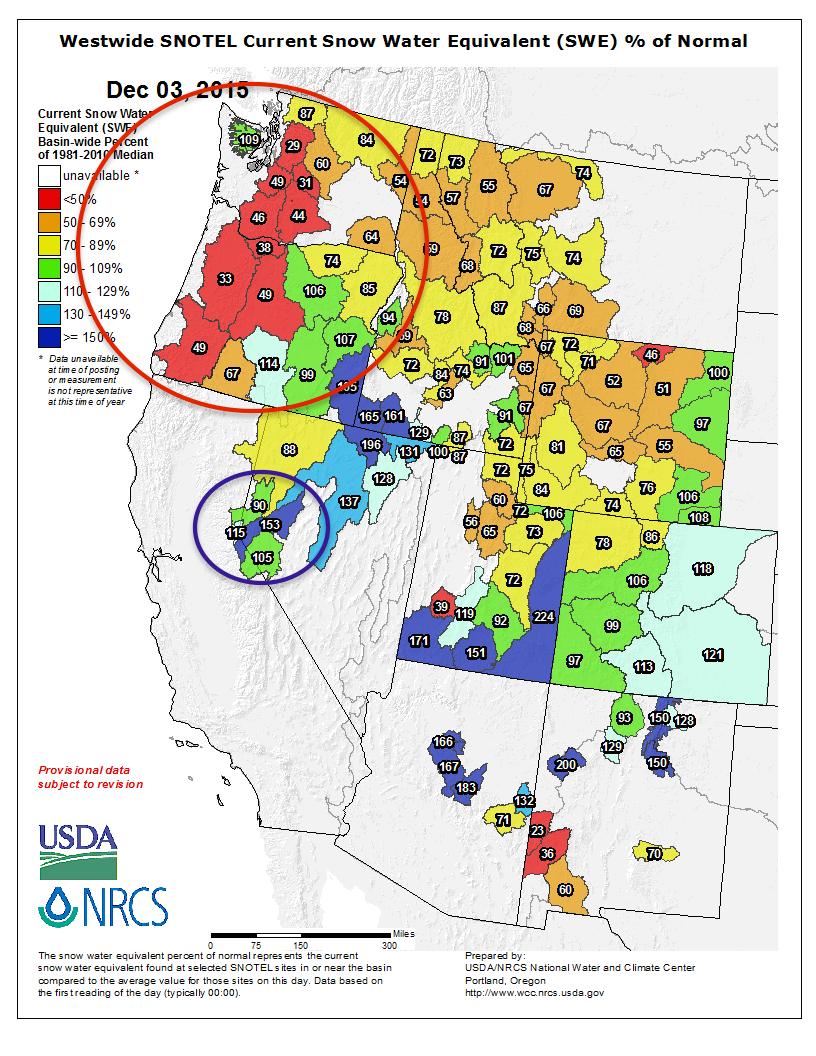
This is good news for a Cascades snowpack that is well below average for early December, from a snow-water equivalent perspective.
Despite heavy WA state QPF events, Cascade #snow water equiv. way behind early Dec. average. Sierra...about right.
This is a pattern that was noticeably, largely absent last fall, winter and spring along the West Coast. Blocking high pressure aloft diverted the jet stream away from the U.S. West Coast last season, leading to the record-paltry Cascades and Sierra spring snowpack.
For the latest information on this complex setup, regularly check back to weather.com for updates.
Storm Reports: Heavy Icing Tuesday Night, Wednesday
The first in the series of impactful weather systems arrived in the region this past Tuesday night into early Wednesday.Freezing rain accumulations of a half inch thick were reported near Skamania, Washington. In Oregon, Troutdale saw ice accumulations of up to one quarter inch thick.
Ice and snow in eastern Oregon from the storm forced school cancelations in Hermiston, Pendleton, Umatilla, Boardman, Milton-Freewater and elsewhere, The Associated Press reported. Icy roads in the Columbia River Gorge also closed or delayed schools on both sides of the Oregon-Washington line.
Wind Reports: Thursday, Saturday
On Thursday, Mount Lincoln in the Sierra of California reported a gust to 106 mph at 2:20 p.m. PST, with sustained winds as high as 74 mph earlier in the afternoon. Squaw Peak in southern Oregon recorded a wind gust of 107 mph just after 8:30 a.m. PST, with sustained winds of 80 mph an hour earlier.Typically windy spots along the Oregon coast also reported strong wind gusts, with Mount Hebo clocking a 72-mph gust just after 9 a.m. PST Thursday.
The greater Reno area had reported just over 5,000 power outages around midday Thursday, most of the power had been restored by Thursday evening. A semi truck flipped over about 5 miles east of town, where local authorities believed high winds were the cause.
Winds were strong enough to partially blow off a metal roof from a structure near Montague, California. In Brookings, Oregon, the National Weather Service relayed reports of down fences, blown in window panes and other minor damage.
The next round of wind on Saturday was much less intense than what was observed two days prior. Although winds gusted to 78 mph atop Crystal Mountain in western Washington Saturday morning, most other wind gusts remained below 60 mph across the region.
MORE: Northwest Powerful Wind Storm, Nov. 18, 2015


No comments:
Post a Comment