By Alex Sosnowski, AccuWeather.com Senior Meteorologist
December 13,2015; 9:48PM,EST
Potentially flooding rain will continue to focus on the central United States into Sunday night as a blizzard unfolds in western Kansas.
While the central U.S. will remain in the midst of tranquil weather into the second week of December, a major storm has taken shape during the second weekend of the month.
According to AccuWeather Chief Meteorologist Elliot Abrams, this will be a dynamic storm as it swings across the Central states.
The storm will bring general travel disruptions to the Central states through Sunday night.
Northwest Flank of Storm to Bring Snow, Blizzard Conditions
Into Sunday night, snow will spread from northeastern New Mexico and the Texas Panhandle to eastern Nebraska. A bit of snow will fall at the beginning and the end of the storm in Minnesota and northern Wisconsin.
"Depending on where the band of heavy snow sets up, snow totals of 6-12 inches are possible within the band into Sunday night," AccuWeather Meteorologist Brett Rathbun said.
"Strong winds will accompany the snowfall and could lead to blizzard conditions at times," Rathbun added.
Enough snow could fall to make for slippery and dangerous travel in some communities. Officials may be forced to close roads in the heart of the blizzard area, which stretches from the Oklahoma Panhandle to south-central Nebraska. This could potentially include a stretch of I-70.
Wet snowflakes could mix in at the tail end of the storm from Omaha, Nebraska, to Minneapolis on Monday.
As quick as this snow event leaves the Plains, another will be approaching from the Rockies and will deliver a wider swath of snow to the northern Plains.
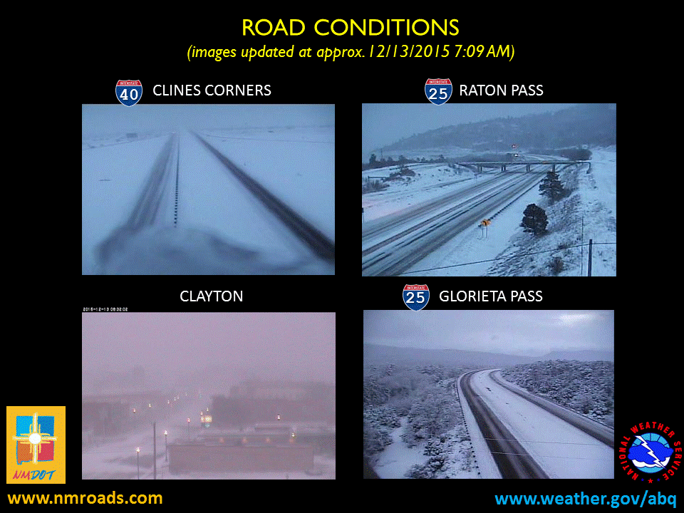
Current Road Condtions from around central and northern NM this snow morning courtesy NMDOT. #NMwx
Another 1-3 inches of rain will fall with locally higher amounts from portions of Texas and Oklahoma to Louisiana, Arkansas, Missouri, and Iowa to end the weekend. Much of this area had two to three times their average rainfall during November.
Soil conditions remain wet and stream levels remain high in much of this area. As a result, the risk of flooding will extend beyond flash and urban concerns to small streams and unprotected areas along some of the rivers.
The greatest potential for flooding will be from the lower part of the southern Plains to the middle and lower Mississippi Valley. This includes portions of the Red River Basin.
RELATED:
AccuWeather Winter Weather Center
US Interactive Radar
Early Week Snowstorm Emerges in Rockies, Sweeps Through Plains
The combination of drenching rain and poor visibility could slow travel in the major metro areas of St. Louis and Kansas City, Missouri; Little Rock, Arkansas; and New Orleans, Louisiana.
Storm to Bring Severe Weather Potential
The combination of warm, moist air and strong winds aloft have sparked severe thunderstorms on Saturday and an isolated threat remains on Sunday.
Wind damage was reported across portions of Texas on Saturday and Saturday night. Two tornadoes touched down in eastern Texas.
On Sunday, the potential for a localized severe thunderstorm will focus on western and southern Louisiana into Sunday evening. The strongest thunderstorms will produce damaging winds with flooding downpours being a more widespread concern.
While the severe weather threat will wind down by Monday, soaking rain will target the upper Great Lakes. Abrams stated that gales would buffet the Great Lakes region with building waves and the potential for lakeshore flooding.
A band of the storm's rain will also quickly hit the Northeast on Monday into Monday night with a wintry mix targeting northern Maine.


No comments:
Post a Comment