By Mark Leberfinger, AccuWeather.com Staff Writer
January 27,2015; 9:01PM,EST
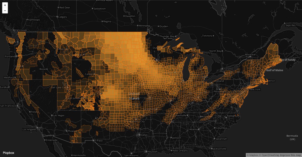
he Upper Midwest and Great Plains are the most common places for a blizzard to occur in the United States, according to an analysis of National Weather Service data.
Meteorologist Devin Boyer analyzed NWS blizzard warnings between 2005 and 2015 and found the Upper Midwest/Great Plains connection.
How often are parts of the US under #blizzard warnings? I was curious so I made a map! http://thecloudonline.net/blizzardwarnings/ …
"High winds are notorious across the Plains," AccuWeather.com Meteorologist Andy Mussoline said. "People tend to correlate blizzards and heavy snow, but it's more about the wind speeds and visibility."
The National Weather Service issues blizzard warnings based on the following criteria during at least a three-hour period: winds of 35 mph or higher and falling and/or blowing snow that brings visibilities down to one-quarter of a mile or less.
"With the terrain in the Midwest and Plains being so flat, the winds are able to be severe on a more regular basis to create blizzard conditions," Mussoline said.
RELATED:
Blizzard Survival Guide: These Tips Could Help Save Your Life
AccuWeather Winter Center
World's 10 Coolest Ice Hotels
While not as frequent as the Midwest and Plains, the Northeast is also susceptible for blizzards because of its proximity to the relatively warm Atlantic Ocean.
"Cold air in the Northeast and the warm ocean help fuel storms, often in conjunction with jet stream energy," Mussoline said.
Warmer air usually dominates in the Southeast U.S., making it less susceptible to blizzards, Mussoline said.
- William Smith · Top Commenter · Inventory at Rem BarYeah and I thought that it was Jamaica and Bermuda that were more susceptible. :-)
 Stefan Mroczkiewicz · Senior Project Manager at TeleCommunication SystemsI am shocked! I assumed it would've been the southeast and west coast...
 Troy Mepyans · Top Commenter · Co-founder at Dragon-Knight PublishingWe had to do a STUDY for this?


No comments:
Post a Comment