Published: March 17,2017
Winter storm season 2016-17 has had a rapid turnaround from slow start in November. It kicked into full gear from mid-December through January and into the first half of February.
At least one named winter storm was active in the first 25 days of January, accounting for six of the storms this winter.
The season has produced 16 named winter storms through mid-February, and many of the most recent winter storms from mid-January onward have arrived near or earlier than average. Winter storm naming by The Weather Channel and weather.com began in the 2012-13 season.
(MORE: How Winter Storms Are Named)
| Winter Storm | Main Region Impacted | Arrival Compared to Average (2012-2016) |
| Argos | Midwest/Northeast | Late |
| Blanche | Midwest | Late |
| Caly | Coast-to-Coast | Late |
| Decima | Coast-to-Coast | Late |
| Europa | Northern Plains | Near Average |
| Fortis | East Coast | Late |
| Gregory | Northwest | Slightly Late |
| Helena | Southeast | Near Average |
| Iras | Northwest | Slightly Early |
| Jupiter | Coast-to-Coast | Early |
| Kori | West Coast | Early |
| Leo | West Coast | Early |
| Maya | Coast-to-Coast | Near Average |
| Niko | Midwest/Northeast | Near Average |
| Orson | Northeast | Near Average |
| Pluto | Northeast | Near Average |
| Quid | Plains/Great Lakes | Near Average |
| Reggie | Northeast | Late |
Climatology Data Provided by Tom Niziol, The Weather Channel
(MORE: The Science Behind Winter Storm Naming)Here is a brief summary of storms that have occurred so far this winter.
Winter Storm Argos, Nov. 17-21, 2016
- Top Snowfall Amount: 54.5 inches near Redfield, New York
Argos was the heaviest snowstorm of record dating to 1905 in Binghamton, New York, where 27.6 inches was recorded at the Greater Binghamton Airport in a 72-hour period ending around midday on Nov. 22. The previous snowstorm of record there was a 24.4-inch three-day storm from Feb. 18-20, 1972.
Winds gusted 50 to 80 mph in the Midwest and the Central Plains, before creating white out conditions on Interstate 81 near Syracuse, New York, as Argos moved toward Canada.
In Minnesota alone, 450 vehicle crashes occurred due to snow and ice, and three deaths were reported. In all, Argos took six lives in Minnesota, New Hampshire and Pennsylvania.
 Winter
Storm Argos left its mark on much of the country. Satellite shows snow
draped from Minnesota to Wyoming and Utah, taken November 19, 2016
Winter
Storm Argos left its mark on much of the country. Satellite shows snow
draped from Minnesota to Wyoming and Utah, taken November 19, 2016( NASA/Aqua/MODIS)
Winter Storm Blanche, Nov. 27 - Dec. 1, 2016
- Top Snowfall Amount: Estimated 62 inches south-southeast of Elk Mountain, Wyoming
Snow fell as far south as Arizona and New Mexico with 10 inches or more falling in both states.
Numerous highways and school districts were closed along the northern tier of the country.
The center of Blanche deepened so much that record low pressures were set from Valentine, Nebraska, to Grand Forks and Fargo, North Dakota, according to David Roth of the Weather Prediction Center. Pressure on Nov. 28 dropped to 975.4 millibars in Fargo, North Dakota. Pressure fell even lower in parts of rural southeastern North Dakota.
(MORE: Winter Storm Central)
Winter Storm Caly, Dec. 7-12, 2016
- Top Snowfall Amount: 46.1 inches at Galena Summit
Caly's snow brought much of the Midwest to a halt. More than 1,300 flights were canceled in Chicago's airports and 200 flights were canceled in Detroit, where a Delta flight slid off the runway. Hundreds of crashes occurred in Minnesota.
 Delta Airlines plane that slid off a runway in Detroit Dec. 11, 2016.
 (Isaac Price/Twitter)
Nine people were killed on roads made more dangerous by snow and ice in Oregon, Iowa, Michigan and Maine.
Winter Storm Decima, Dec. 13-18, 2016
- Top Snowfall Amount: 35.4 inches in Ketchum, Idaho
- Top Ice Amount: 0.88 inches in Springfield, Oregon
Decima brought wind, freezing rain and snow to the Northwest stopping traffic from moving for two days in some areas. More than three-quarters of an inch of ice fell in Eugene followed by two days of mainly sub-freezing weather led to a standstill.
Hundreds of accidents including an eight-car pileup occurred in Oklahoma, Missouri and Nebraska as Decima accelerated toward the northeast.
This mid-December storm caused a major pile-up in Maryland after a tanker explosion on Interstate 95 on Dec. 17.
Winter Storm Europa, Dec. 21-26, 2016
- Top Snowfall Amount: 32 inches at the top of Mammoth Mountain
- Top Ice Amount: 0.70 inches near Alexandria, Minnesota
Europa created most of its impacts in portions of the Northern Plains, especially near Bismarck, North Dakota, where a snow emergency was declared. Blizzard conditions occurred across much of the Dakotas, and more than a foot of snow fell across North Dakota.
Winds gusted to more than 70 mph in five states across the Northern Plains, and brought heavy snow from the West to the Midwest.
More than 200 miles of I-90 were closed in South Dakota due to snow and ice.
 Snow-covered Weiser, Idaho is photographed on Friday, Dec. 23, 2016 during Winter Storm Europa.
(gandolfjohn/instagram)
Winter Storm Fortis, Dec. 28-30, 2016
- Top Snowfall Amount: 29.0 inches in Kingfield, Maine
Fortis clobbered Maine with heavy snow and brought gusty winds to much of New England. Fortis even brought thundersnow to portions of Connecticut, New York and Maine.
More than 100,000 people lost power in Maine on Dec. 30, and one person lost control of their vehicle, hit a tree and lost their life during the storm.
 Winter Storm Fortis in the process of intensifying near the coast of Maine on December 30, 2016.
 Winter Storm Gregory, Jan. 1-3, 2017
- Top Snowfall Amount: 17 inches at Mount Hood Meadows, Oregon
- Top Ice Amount: 0.25 inches in Winslow, Poland and near Jonesboro, Maine
Gregory kicked off a three and a half week onslaught of winter storms that kept going until Jan. 25 when Leo dissipated.
Winter Storm Helena, Jan. 3-7, 2017
- Top Snowfall Amount: 56 inches in Boreal and Soda Springs, California
- Top Ice/Sleet Amount: 2.0 inches near Falls Lake, North Carolina
Schools and roads across the South and East from Alabama to Virginia were closed for days after a dose of freezing rain, sleet and snow. Days of sub-40 degree weather kept some roads icy as much as five days after the ice fell.
Blizzard conditions with snow, sleet and low visibility were reported eastern Virginia.
Snow also fell along parts of the Northeast I-95 corridor before Helena moved out to sea. New York City picked up 5.1 inches of snow from Helena, while Boston saw 7.2 inches of snowfall.
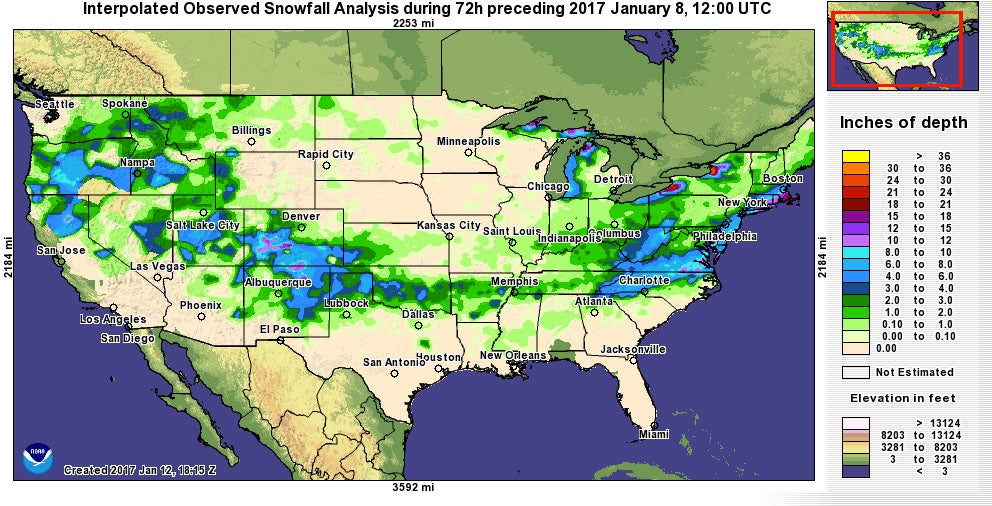 Snowfall for January 5-8, 2017 including snow from Winter Storm Helena.
 Winter Storm Iras, Jan. 6-10, 2017
- Top Snowfall Amount: Estimated 48 inches near Driggs at the Grassy Lake Snotel, Wyoming
- Top Ice Amount: 0.75-1 inch of ice in Creswell, Oregon
Iras impacted numerous large cities in the West including Eugene and Portland, Oregon, Salt Lake City, and Grand Junction, Colorado. Portions of the Northwest picked up more than a half-inch of ice, some of which was later covered by snow. Eugene, Oregon, saw more than four inches of snow on top of three-quarters of an inch of ice, making roads treacherous.
Blowing snow brought traffic to a standstill in southern Minnesota as Iras moved through the Midwest. Minnesota troopers responded to more than 100 traffic incidents as a result.
 Traffic
moves slowly along Interstate 5 through Eugene and Springfield, Ore.
area as a winter storm moves through the Willamette Valley Sunday Jan.
8, 2017. Snow and sleet are making for treacherous roads in Oregon, with
the state police warning that they can't keep up with all the crashes.
Traffic
moves slowly along Interstate 5 through Eugene and Springfield, Ore.
area as a winter storm moves through the Willamette Valley Sunday Jan.
8, 2017. Snow and sleet are making for treacherous roads in Oregon, with
the state police warning that they can't keep up with all the crashes.(Chris Pietsch/The Register-Guard via AP)
Winter Storm Jupiter, Jan. 11-19, 2017
- Top Snowfall Amount: 94.5 inches near Encampment at the Old Battle Snotel, Wyoming
Heavy thundersnow was reported in Oregon and Washington Jan. 9-12, totaling more than a foot of snow in the Portland area. This was the biggest single-day snowstorm for Portland in 22 years. More than 12 feet of snow was deposited in portions of the Sierra Nevada Mountains in California.
Avalanches and heavy snow closed some parks and ski areas even had to close because of the staggering amount of snow.
Jupiter dropped more than 4 feet of snow in four western states, and snow and ice fell as far south as New Mexico and northern Texas.
During the weekend of Jan. 14-15, heavy icing from Jupiter left a mess of downed trees and power outages across parts of the Plains, namely the Texas panhandle, northwest Oklahoma, Kansas and Nebraska. Parts of northwest Oklahoma and west Kansas saw ice accumulations of up to an inch thick.
Jan. 16-19, more ice and snow fell across portions of the Midwest and Northeast. In general one-tenth to a third of an inch of ice fell in the Midwest. Jupiter began to lose steam in the Northeast, but not before dropping a half-inch layer of ice on Fairfield, New York. About 2-7 inches of snow fell in New York and across northern New England.
 Taken
Sunday morning of January 15, 2017, in Canadian, Texas, a home at the
corner of Purcell and Sixth streets is surrounded by dismembered trees
and branches. Ice-clad power lines lined the entire city, and many were
reported down.
Taken
Sunday morning of January 15, 2017, in Canadian, Texas, a home at the
corner of Purcell and Sixth streets is surrounded by dismembered trees
and branches. Ice-clad power lines lined the entire city, and many were
reported down. (The Canadian Record)
Winter Storm Kori, Jan. 17-25, 2017
- Top Snowfall Amount: Up to 30 inches at Mammoth Mountain, California
- Top Ice Amount: Up to 2 inches in North Bonneville and Snowden, Washington
On the northern side, ice accumulations 1-2 inches thick encased some locations in northern Oregon and southern Washington, namely the Columbia River Gorge and upper Hood River Valley.
On the southern side, more than a foot of rain fell in parts of central California, leading to hundreds of reports of flooding and swollen rivers. Two feet of snow fell in parts of the Sierra Nevada mountains.
Cabins were washed away in a burn area near Santa Barbara, California, after heavy rain moved through. Wind gusts up to 50 mph pushed over trees where soil had gotten super saturated in central California.
Kori, along with the abundance of winter storms this season, effectively ended the long-term exceptional drought across northern and central California and parts of Oregon and Nevada.
Schools were closed as far south as Flagstaff, Arizona, due to heavy snow.
Winter Storm Leo, Jan. 22-25, 2017
- Top Snowfall Amount: 60.5 inches near Incline Village, Nevada
Schools were closed in Reno, Nevada, and Flagstaff, Arizona, due to heavy snowfall.
Due to the heavy rain in the weeks before this storm with additional rainfall on top of that, trees fell and rockslides were reported.
At least five people were killed in Winter Storm Leo, mainly due to floodwaters.
Numerous accidents were reported in the Midwest and Northern Plains as snow made roads dangerous. A 100-mile stretch of interstate in South Dakota was even shut down. A few spots in Nebraska saw 20 inches of snow.
Winter Storm Maya, Feb. 5-7, 2017
- Top Snowfall Amount: 62.5 inches in East Glacier Park, Montana
- Top Ice Amount: Up to 0.50 inches in Glens Falls and Fairfield, New York
The highest impact from the storm in the Pacific Northwest was in Seattle which saw 7.1 inches of snow Feb. 5-6, making it the heaviest two-day snowstorm there since Jan. 18-19, 2012.
On Feb. 5, heavy rain dislodged roadsides in the Portland area and a landslide closed the Historic Columbia River Highway in northern Oregon east of Portland.
More than 100,000 customers found themselves without power on Feb. 6 in Washington's Puget Sound area.
Blizzard conditions were observed near Glacier National Park in Montana, where snowdrifts up to 10 feet high were reported on U.S. 2 Feb. 6. East Glacier National Park had saw up to 51 inches of snow.
Maya brought mainly light to moderate snowfall accumulations to parts of the Midwest near the Canadian border Feb. 6-7, but freezing drizzle caused a messy morning commute on Feb. 7 in Minneapolis. The storm then delivered snow and ice to New England and Upstate New York Feb. 7-8.
Up to a half inch of ice accumulated in Upstate New York on Feb. 7, including in Glens Falls and Fairfield. Trees and powerlines were knocked down in some areas of Upstate New York due to the weight of the ice.
Light freezing rain impacted Boston early Feb. 8 as Maya was departing leading to numerous travel problems.
The video above was taken from St. Mary, Montana, just east of Glacier National Park, on the evening of Feb. 5.
Winter Storm Niko, Feb. 7-9, 2017
- Top Snowfall Amount: 24 inches near Cooper, Maine.
The intense storm underwent "bombogenesis", which is defined as a drop in central pressure of the surface low of at least 24 millibars in 24 hours or less, off the Eastern Seaboard when it's pressure dropped 29 millibars in 24 hours. Pressure fell from 1002 millibars (mb) to 973 mb from 7 p.m. Feb. 8 to 7 p.m. Feb. 9.
Snowfall rates were extreme at times from New York through southern New England, ranging from 1 to 4 inches per hour. Thundersnow was observed in New York, Connecticut, Massachusetts, and Rhode Island.
(MORE: Lightning Obliterates Tree, Damages Home in Rhode Island during Thundersnow)
New York City's La Guardia Airport saw three inches of snow per hour for two straight hours 8-10 a.m. EST on Feb. 9. Islip, New York, saw two- to three-inch per hour snowfall rates from 9 a.m. to noon EST.
Albany, New York, picked up 4 inches of snow in one hour early Feb. 9.
At least 19 locations in southern New England recorded blizzard conditions.
Boston recorded blizzard conditions for more than four and a half hours. At one time, visibility at Logan Airport dropped to a mere 1/16 of a mile, a rarity in a winter storm.
This was the first blizzard in Boston since Jan. 27, 2015 (Winter Storm Jonas), which lasted 9 hours. In Providence, blizzard conditions were recorded for more than five hours.
One person was killed by Niko in New York City while shoveling snow.
Four thousand flights were canceled nationwide to do heavy snow in the Northeast. New Jersey and Connecticut state police responded to a combined 1,200 calls during the storm.
Snow emergencies were declared in Philadelphia and Boston and schools closed across the region.
 Men
try to push a stuck motorist from the roadway during Winter Storm Niko,
Thursday, Feb. 9, 2017, in Marlborough, Mass. (AP Photo/Bill Sikes)
Men
try to push a stuck motorist from the roadway during Winter Storm Niko,
Thursday, Feb. 9, 2017, in Marlborough, Mass. (AP Photo/Bill Sikes) Winter Storm Orson, Feb. 10-13, 2017
- Top Snowfall Amount: 40 inches in Hudson, Bradford and Glenburn, Maine.
Blizzard conditions occurred in parts of Maine into Canada's Nova Scotia province.
High winds from the storm also triggered numerous power outages up and down the East Coast, including areas that received no snowfall from the storm. Washington, D.C. saw a gust to 66 mph and White Plains, New York, clocked a gust to 72 mph
Many locations in Maine received more than two feet of snow from Orson. Parts of upstate New York, Vermont, New Hampshire and Massachusetts saw more than a foot of snow.
Glenburn, Maine, was buried under 40 inches of snowfall, which combined with 10 inches from Winter Storm Niko, brought their total to 50 inches in less than a week.
Drifts 8 feet high were reported in Sherman, Maine.
(MORE: Winter Storm Orson Looked Like a Hurricane as It 'Bombed Out')
Orson claimed two lives as it moved through the Northeast. Strong winds brought down numerous tree limbs across the Mid-Atlantic, including one that crashed through the windshield of Shannon Lee Martin's car near Mechanicsburg, Pennsyvlania. The branch struck him in the chest, breaking his ribs and lacerating his heart.
A veteran was killed by a snowplow in the parking lot of a veterans' facility in Bedford, Massachusetts on February 12.
The weight of the snow collapsed the roof of a bowling alley in Millinocket, Maine and caused travel disruptions both on the ground and in the air from Upstate New York to Maine.
Winter Storm Pluto, Feb. 15-16, 2017
- Top Snowfall Amount: 19.0 inches in Corinna, Maine.
At least one person died driving on snow-covered roads in Vermont and another person died in a four-car collision in Upstate New York, but it is unclear whether or not that collision was directly related to Pluto.
So much snow fell in Maine, New Hampshire and Vermont in early-mid February that snow shovels were becoming hard to find during this storm, even as residents were cautioned to clear snow from rooftops in fear that the weight of the snow might collapse structures.
Winter Storm Quid, Feb. 22-24, 2017
- Top Snowfall Amount: 34.0 inches near Lander, Wyoming.
Quid killed four people in northern Utah in deadly car accidents due to slick roads.
On the northern side of Quid, blizzard conditions were observed late Feb. 23 in Mason City, Iowa, and Forest City, Iowa. Thundersnow was reported from eastern Nebraska to Lower Michigan and in Wisconsin.
Parts of Wisconsin picked up daily record snowfall amounts and schools were closed in spots across the Midwest in anticipation of the snow.
Winter Storm Reggie, Mar. 9-10, 2017
- Top Snowfall Amount: 9.5 inches in Yostville, Pennsylvania
This winter storm brought snowfall from Ohio to New England, stopping air traffic at New York's LaGuardia Airport and at Newark.
Much of the Northeast saw in excess of four inches of snow.
In the days following Reggie, cold air was pushed southward from Canada across much of the eastern half of the United States, which for some was the first span of below average temperatures in weeks.
Our meteorologists and writers Sean Breslin, Ada Carr, Eric Chaney, and Pam Wright contributed content to this winter storms summary.
MORE: Winter Storm Helena
The Weather Company’s primary journalistic mission is to report
on breaking weather news, the environment and the importance of science
to our lives. This story does not necessarily represent the position of
our parent company, IBM.
No comments:
Post a Comment