Published: November 17,2015
As many as 23 unconfirmed tornadoes have
struck a swath of Texas, Oklahoma, Kansas and Nebraska, causing damage
in at least two of those states as a severe weather outbreak unfolds
across the central and southern Plains. Officials in Texas said one of
the tornadoes destroyed an oil and gas facility, raising concerns about
radioactive material stored there.
The storms also
brought strong non-tornadic winds to some areas, and in Texas and
Oklahoma combined, some 47,000 customers woke up without power Tuesday
morning. So far, there have been no injuries reported from these storms.
(FORECAST: Severe Weather Outbreak)
The
damaging storms are developing on the warm side of Winter Storm Ajax,
which will bring blizzard conditions to the High Plains.
It's
important to note that although the Storm Prediction Center reported 38
tornadoes Monday, some of these reports may be duplicates or
non-tornadic wind damage. The National Weather Service will investigate
each tornado report in the coming days to determine whether the damage
was caused by tornadoes or just straight-line winds.
Here is a roundup of damage reports and other storm-related impacts.
Arkansas
Nearly
15,000 customers were without power Tuesday afternoon in Arkansas as
the storms began to fire up, the Associated Press said. Garland County
had the highest number of outages, the report added.
There
were also reports of wind damage coming in early Tuesday afternoon.
Trees were brought down in Hempstead County, and cabins were damaged
along Lake Hamilton Drive in Garland County, the AP also reported.
The Hot Springs City Hall building was also damaged Tuesday afternoon, the Sentinel-Record reported via the AP.
Texas
At
least seven tornadoes have struck the Texas Panhandle, including a
tornado just south of Pampa that was reported to be as wide as a mile.
The
storm that spawned the monster tornado first spawned a brief tornado
near Groom at 6:11 p.m. CST. That tornado apparently dissipated, but a
new tornado touched down a short time later and struck areas south and
southeast of Pampa. Spotters said it was a mile wide as it passed about 4
miles southeast of the downtown area of Pampa, a city of 18,000
northeast of Amarillo, around 6:40 p.m. local time.
An NWS survey team gave the Pampa tornado a preliminary rating of EF3.
A
second tornado touched down near Groom shortly before 7 p.m. and while
the tornado near Pampa was still on the ground. That tornado struck the
south side of Pampa around 7:08 p.m.
The National Weather Service said
one of the Pampa tornadoes caused unspecified "major damage" as well as
gas leaks and downed power lines on the south side of Pampa. Amarillo
television station KAMR said via Twitter that two Gray County Sheriff
deputies were sickened by the gas leak.
"We believe
that they were just exposed to a natural gas leak," Gray County Chief
Deputy Steven White said in an interview with The Weather Channel. "They
reported a chemical smell which could've possibly been an oil additive,
but we believe the actual hazard they were exposed to was a natural gas
leak."
According to Gray County Emergency Coordinator
Sandi Martin, chemical spills and gas leaks were contained after
the Halliburton plant in Pampa was leveled in the storm. Nobody was
inside the building at the time it was destroyed, ABC Amarillo reported.
There were no injuries reported from this incident, KAMR-TV said.
"The Halliburton plant was a near total loss, and I know we've completely lost two residences in the county," White added.
More than 1,000 Xcel Energy customers remained without power in the panhandle Tuesday morning.
A
BNSF Railway train was derailed after a major storm in Roberts County,
according to KVII-TV. Officials say the storm pushed the train off its
tracks near Miami. Downed power lines in the area initially prevented emergency crews from reaching the scene of the accident.

Tornado Reports
The pair of supercell thunderstorms remained tornadic as they moved northeastward together, passing near Miami
and Canadian. Tornadoes were reported near both of those towns. It is
not immediately clear whether the tornadoes had stayed on the ground
continuously since the Pampa area.
Farther north, a
confirmed EF1 tornado was reported east of Perryton, Texas, at 7:05 p.m.
CST. What was likely the same tornado was reported 4 miles west of
Booker, Texas, at 7:12 p.m. CST. Subsequent reports placed the tornado 3
miles northwest and then 4 miles north of Booker as it crossed the
state line into the Oklahoma Panhandle by 7:24 p.m. Spotters said it was
a multiple-vortex tornado during part of that time, and a satellite
tornado touched down near the larger tornado at least briefly.
Spotters also reported a tornado near White Deer at 6:51 p.m. CST.
Another
tornado was reported 12 miles southwest of Wolf Creek Park in the Texas
Panhandle at 8:28 p.m. as it crossed U.S. Highway 70.
(PHOTOS: Tornado Outbreak in the Plains)
Yet another tornado was reported 8
miles south of Booker at 9:06 p.m., and was spotted 12 minutes later
near Darrouzett before moving northeast into the Oklahoma Panhandle.
Large
hail also affected parts of the Texas Panhandle. The tornadic
thunderstorms in the Pampa area dropped golfball-size hail on the south
side of Pampa. There were a few other reports of hail to the size of
golfballs in rural areas of the Texas Panhandle.
The storms moved into the Dallas-Fort
Worth area Tuesday morning – an area that has had its wettest year
to-date. The nasty weather blew the roof off a building south of
Weatherford around 2:45 a.m. The storms then moved into Tarrant County,
including Fort Worth, where power line flashes were reported due to high
winds in the city.
In Keller, north of Fort Worth, the
National Weather Service confirmed a tornado was in progress Tuesday
morning. The NWS has yet to assign an EF rating to this confirmed
tornado.
Emergency management officials said the storms overturned a tractor trailer in a parking lot near Lewisville, just northwest of Dallas,
trapping the occupant. WFAA.com said there was widespread tree damage
in one Hurst neighborhood. Several other towns in the area reported
similar damage.
Power utility Oncor said some 44,000 customers were without power as of 4:40 a.m. CST.
Oklahoma
At least three tornadoes affected Oklahoma; two of them moved into the state from Texas.
As
noted above, a tornado that touched down in the far northern part of
the Texas Panhandle then crossed into the Oklahoma Panhandle shortly
before 7:30 p.m. CST south of Elmwood in Beaver County, according to
spotter reports relayed by the National Weather Service in Amarillo,
Texas.
Another tornado moved into Oklahoma from Texas
about two hours later. Spotters saw the tornado 8 miles southwest of
Slapout in Beaver County at 9:29 p.m. CST.
(MORE: Winter Storm Ajax Hits the Rockies)
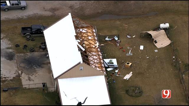
WATCH LIVE NOW: We are live-streaming storm damage in Perry, Oklahoma. http://www.news9.com #okwx
Around the same time, spotters
reported a tornado 4 miles east of May after the pair of storms that had
earlier produced tornadoes near Pampa, Texas, merged into a single
supercell. There were additional tornado sightings from this cell in
Harper County just southwest of Selman before it moved into Kansas.
Storms
organized into a squall line west of Interstate 35 late Monday evening.
As the line charged eastward, it produced a wind gust of 99 mph just
east of Interstate 35 in Red Rock at 1:55 a.m. CST Tuesday. The website
of power utility OG&E showed nearly 900 customers without power in
nearby Billings shortly after the storms tore through.
As of 4:50 a.m. CST, nearly 7,000 OG&E customers lacked electricity; the Billings outage remained unresolved.
Public
Service Company of Oklahoma reported about 500 customers without power
just before 5 a.m. CST, mostly in northeast Oklahoma.
Kansas
A
tornado that moved from Ensign to Howell Monday night was given a
preliminary rating of EF2, the National Weather Service's Dodge City
office said Tuesday.
At least 11 tornadoes have been
reported so far in Kansas, and a 12th moved into the state from
Oklahoma, according to our latest analysis of storm reports from the
NWS.
According to the NWS, storm chaser observed a
tornado south of Ulysses just before 4 p.m. CST. Local schools held
their students until the system passed through.
“The
coast is clear and everyone was sent home, safe and sound. District
coordinated with local emergency management officials, who determined
the severe threat was over,” said superintendent of Ulysses Public
Schools Dave Younger. No injuries or substantial damage were reported.
Emergency management reported a tornado 11 miles north of Pierceville in Finney County at 5:19 p.m. CST.
At
5:20 p.m., a small tornado was reported 4 miles southeast of Grinnell
in northwest Kansas. Several other reports of tornadoes came from that
same cell in the Grainfield and Gove areas of Gove County, along
Interstate 70. Those reports may have been a single tornado. The tornado
damaged roofs, broke windows, destroyed sheds and downed power lines
and trees in the area.
(MORE: Flood Threat Looms for Gulf Coast, Mississippi Valley)
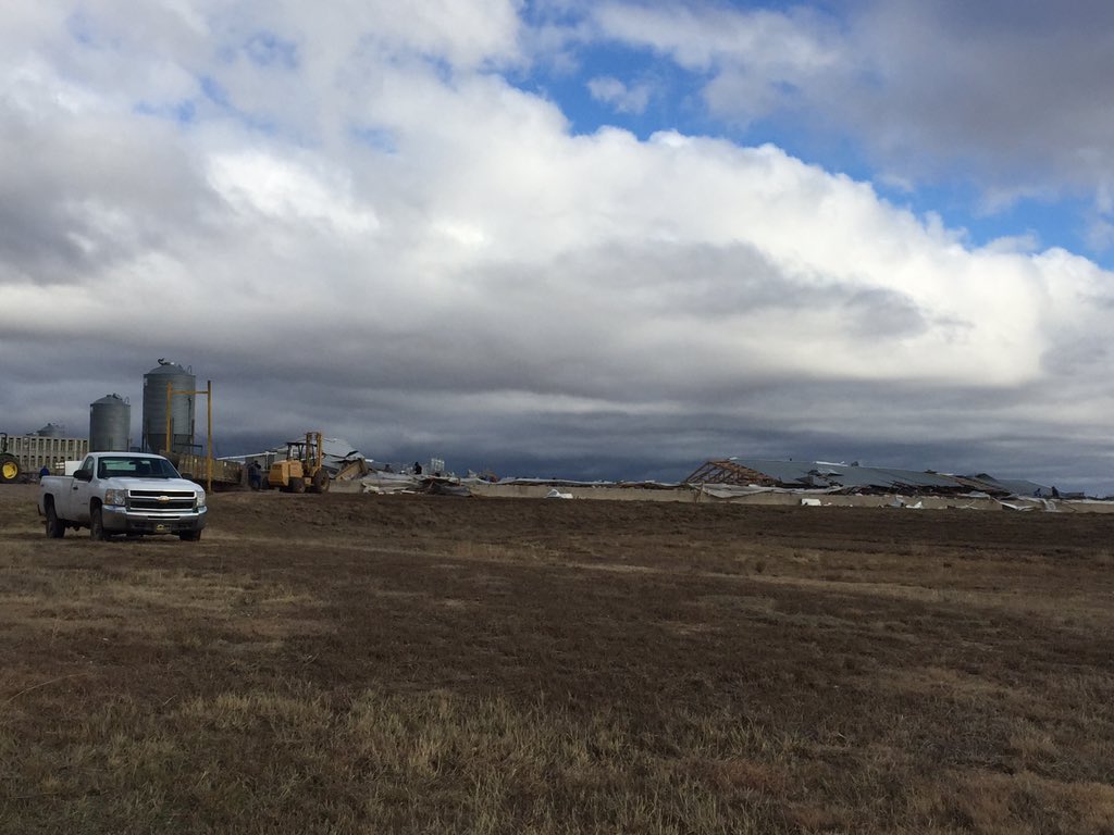
Hog farm destroyed just west of Kismet. 5 barns destroyed. Keeping distance because they are still rounding up hogs
Just before 6 p.m. CST a large
tornado was also reported near Kismet, and debris was reported in the
air near Hayne, according to the National Weather Service in Dodge City.
A residence and several hog farms were damaged outside of Kismet, where
the tornado was estimated at a quarter-mile wide by a storm chaser.
The NWS rated this tornado EF3 in its preliminary survey of the damage left behind.
KAMR-TV
in Amarillo said a hog farm and mobile home in Seward County were
destroyed by the tornado. A roof was ripped off of a house and a
separate garage was damaged in the same area. The families affected were
able to take shelter, and no injuries were reported.
At
6:29 p.m., the National Weather Service said "a large tornado continues
and is very well defined from observers" 8 miles north-northwest of
Missler from the same cell that produced the tornado near Kismet. It is
not immediately clear whether the tornado had been on the ground
continuously since hitting the Kismet area.
A tornado
struck a rural area 15 miles south of Hoxie in northwest Kansas at 6:43
p.m., downing power lines along Kansas Highway 23. Another tornado was
reported by a spotter at 6:44 p.m. just west of Ransom, Kansas. National
Weather Service radar detected a tornado debris signature in the area.
That tornado knocked down 17 or 18 power poles near Arnold, Kansas, and
was later spotted north of Cedar Bluff around 7 p.m.
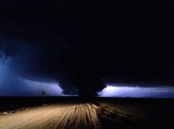
TORNADO OUTBREAK-- 36 tornadoes reported in Texas, Oklahoma and Kansas...where this pic from @skewy11 was taken.
A tornado was reported near Tasco at
7:06 p.m. CST. Law enforcement officials said the tornado damaged a
residence and outbuildings.
In southwest Kansas, a
tornado damaged a barn near Montezuma at 6:45 p.m. It may have been the
same tornado later blamed for damaging a residence near Howell in Ford
County. Between those damage incidents, the twister was spotted by law
enforcement just north of Ensign at 7:06 p.m. CST.
At
7:39 p.m. CST, law enforcement and a firefighting unit reported two
"rope" tornadoes in rural Hodgeman County about 11 miles east of
Kalvesta.
A tornado that was spotted in Harper County,
Oklahoma, crossed the state line and damaged two homes in rural Comanche
County, Kansas, around 10:20 p.m., according to law enforcement reports
relayed by the National Weather Service in Dodge City.
There
were several reports of golfball-size hail across western Kansas,
according to NWS reports. Hail up to 2 inches in diameter, slightly
larger than golf balls, cracked a vehicle's windshield north of
Pierceville.
Nebraska
The National
Weather Service in Hastings said a spotter reported a tornado 5 miles
southwest of Stamford in rural Furnas County at 7:51 p.m. CST.


No comments:
Post a Comment