Published: December 6,2016
The record warmth that much of the U.S. experienced this fall is abruptly coming to a halt this week. A change is setting in, courtesy of the first arctic blast of the season, which has already engulfed the western states and will continue to spread east throughout much of the Lower 48 into the weekend.
(MORE: Record Warm Fall For Many Cities)
The pool of arctic air that has begun to invade the Lower 48 originated in Alaska and northwestern Canada.
Parts of Alaska saw frigid conditions over the weekend, with lows dipping to minus 36 degrees in Fairbanks on Sunday. Though very cold, it's still quite far from their daily record of minus 53 degrees for the day. Arctic Village, Alaska, saw their temperature dip to minus 42 degrees Sunday.
(MORE: Frigid Cold -30s and -40s Descend Into Alaska)
A pattern change has now dislodged that arctic air, allowing it to spill southward in the days ahead.

Current Temperatures
(MAPS: 10-Day Forecast)

24 Hour Temperature Change
(MORE: December Temperature Outlook)
How Cold Will It Get, and When?
Big temperature drops are anticipated, with highs and lows falling 20 to 30 degrees.These very cold conditions were first felt in the northern Rockies on Monday and are now spreading through much of the West and into portions of the northern and central Plains.
(FORECAST: Great Falls, Montana | Salt Lake City | Denver | Albuquerque, New Mexico)
The first sub-zero temperatures of the season for some locations are expected through Thursday morning, from the Rockies to the northern Plains. Great Falls, Montana, dipped below zero late Monday night for the first time this season and Cut Bank, Montana, saw sub-zero temperatures early Tuesday morning.

Forecast Morning Lows
Even with these very cold temperatures, widespread record lows are not expected.
(FORECAST: Bismarck, North Dakota | Omaha, Nebraska | Chicago | St. Louis)
It will be windy, as well, which will make it feel even colder than what the thermometer reads, resulting in brutal wind chills.
In addition, snow will accompany the cold temperatures in some locations, including the northern Plains.

Forecast Highs Compared To Average
Late in the week, the colder conditions will reach the East Coast.
(FORECAST: New York | Washington, D.C. | Atlanta | Orlando)
At this time, it appears that temperatures will not be as cold for the East as for the West and Plains. However, it will feel much more like winter.

This Week's Forecast
Many areas in the South will experience a hard freeze late this week with lows dipping well into the 20s, including Atlanta, Nashville and Raleigh.
The Ohio Valley, southern Great Lakes and mid-Mississippi Valley will see lows crash into the teens later this week. Chicago, St. Louis and Columbus, Ohio, are among the cities where the mercury will plunge into the teens.
(MORE: The Coldest Temperatures Ever Recorded in Each State)

Forecast Morning Lows
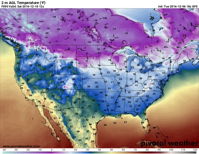
In fact, forecast model guidance over the past few days has been suggesting all 50 states will include an area that is below freezing Saturday morning.
The GFS
continues to suggest all 50 states will include an area that is below
freezing Saturday morning (Hawaii and Alaska not shown). #cold
(MORE: 5 Things to Know About Arctic Cold Fronts and the Plummeting Temperatures They Produce)


No comments:
Post a Comment