Published: November 29,2016
Winter Storm Blanche will continue to bring snow and strong winds to the northern Plains through Wednesday, leading to poor visibility and dangerous travel conditions at times. Blanche will also bring additional snowfall to northern Maine through Thursday.
(MORE: How Winter Storms Are Named)

Current Radar
(MORE: Winter Storm Central)

Winter Weather Alerts
The highest total from Blanche, so far, was estimated at 56 inches near Elk Mountain, Wyoming.
(LATEST NEWS: Blanche Dumps Heavy Snow in West, Northern Plains)
In the northern Plains, locally just over 20 inches of snow has piled up in North Dakota near Hannover, while South Dakota's Black Hills have seen more than a foot of snow.
The photo below shows the heavy snow that has fallen in Beulah, North Dakota. See the bottom of this article for more specific reports.
Northern Plains Wind-Driven Snow
Blanche's surface low-pressure system has pivoted northeastward into the northern Plains. That gyre of strong, surface low pressure will remain parked in place into early Wednesday, wringing out more snow around it.Here's a general look at the timing:
- Into Wednesday Morning: Snow will persist in areas of the western and central Dakotas, while the eastern Dakotas will see a transition to all snow. A mix of rain and snow will be found across much of Minnesota and perhaps into sections of northwestern Iowa and western Wisconsin.
- Wednesday: Rain will have changed to light snow in parts northern/western Minnesota and northwest Iowa, while continuing in the Dakotas. Rain may change to snow or mix with snow in eastern parts of Minnesota and Wisconsin by Wednesday night.

Wednesday's Forecast
The central and western Dakotas will see the greatest addional accumulations through Wednesday. Light amounts are possible in the eastern Dakotas and western Minnesota.
(FORECAST: Bismarck, North Dakota | Pierre, South Dakota | Minneapolis, Minnesota)

Snowfall Forecast Through Wednesday
(MORE: Yes, There is a Blizzard Alley)
Wintry Weather in Interior New England
As mentioned before, moisture associated with Blanche is interacting with sufficient cold air in interior New England to produce wintry weather there.Pockets of freezing rain were observed early Tuesday morning in parts of western New England. Snow has been falling in Maine, as well.

Snowfall Forecast
Snow Totals and Reports From Winter Storm Blanche
Snow from Blanche in the western states has been caused by a potent southward plunge of the jet stream that has pivoted through that region and into the central United States since this weekend.The energy associated with that jet-stream dip spawned an area of surface low pressure in the Plains, where snow and gusty winds are ongoing.
Moisture from Blanche is also pushing well east of that low, producing wintry weather in interior New England through midweek, particularly in northern Maine.
Here are some of the top snow totals by state from Blanche, as of Tuesday afternoon.
- Arizona: 9 inches near the Arizona Snowbowl; 5.5 inches in Flagstaff
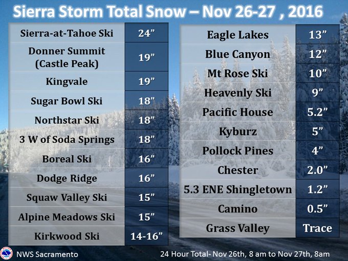
- California: 24 inches at Sierra-at-Tahoe Ski Resort
- Colorado: 28 inches near Wolf Creek Pass
- Idaho: 13.5 inches south of Pocatello
- Montana: 7 inches near Big Sky
- Nevada: 10 inches at Mount Rose Ski Area
- New Mexico: Estimated 14 inches at Taos
- North Dakota: Estimated 21 inches in Hannover
- South Dakota: 16 inches near Brownsville; 3 foot drifts near Lead
- Utah: 41 inches at Alta
- Wyoming: Estimated 56 inches south-southeast of Elk Mountain
Here are some preliminary snow totals from the storm that went through yesterday & overnight. #snow #cawx #Norcal
MORE: Winter Storm Blanche, November 2016 (PHOTOS)


No comments:
Post a Comment