Published: June 4,2016
A tropical depression or tropical storm will likely form in the Gulf of Mexico, possibly as soon as later Sunday, bringing a threat of heavy rain to parts of Florida and the Southeast coast Monday and Tuesday.
(MORE: Hurricane Season Outlook | Hurricane Season Q & A | Debunking Hurricane Myths)
Clusters of thunderstorms continue to flare up in the western Caribbean Sea, but, as yet, have not consolidated in any one location to help begin the process of lowering surface pressure and forming a tropical cyclone.

Current Satellite, Surface Winds

Current Satellite, Wind Shear
With upper-level high pressure centered to the east from the Bahamas to the central Caribbean Sea and broad low pressure aloft centered over South Texas, this area of disturbed weather will be steered into the Gulf of Mexico by Sunday or Monday.
(MORE: 8 Things to Know About the Hurricane Season)
 General
setup expected early next week, featured a trough of low pressure (the
tropical disturbance) being steered into the Gulf of Mexico with a plume
of deep moisture.
General
setup expected early next week, featured a trough of low pressure (the
tropical disturbance) being steered into the Gulf of Mexico with a plume
of deep moisture.- How much this disturbance will strengthen. At a minimum, it is expected to become a tropical depression (maximum winds less than 39 mph), but could strengthen to a tropical storm.
- Exactly where it will track.
For now, the majority of forecast guidance suggests the upper-level features described earlier will curve the disturbance, in whatever form it takes, toward the Florida Peninsula sometime in the late-Monday or early Tuesday timeframe, then somewhere near or off the coast of the Carolinas by later Tuesday.
(MORE: Florida's Record-Setting Hurricane Drought)
It will not have much time to strengthen appreciably, and at least some wind shear will remain it place as it tracks toward the Gulf Coast.
If it becomes a tropical storm, it would be named "Colin", the season's third named storm.

Forecast Model Tracks
Thus, areas of heavy rain and flash flooding appear likely, even ahead of the arrival/landfall of the surface low-pressure center to the east, northeast and southeast of the track of the system.
(MORE: Florida's 'Wet Season' Is Here)
The rainfall outlook is uncertain beyond Florida, as the system may intercept a cold front arriving from the Appalachians (a common heavy-rain scenario), but also be accelerating quickly out to sea (minimizing the duration of any heavy precipitation).

Rainfall Outlook Through Tuesday
Gusty winds and even a few tornadoes are also possible as the system passes through late Monday into early Tuesday.
If you have vacation plans in Florida or along the Southeast coast, we don't yet suggest canceling those plans. But do check back with us at weather.com for the latest on this system.
However, be aware there may be a period of time Monday and Tuesday where rainfall in parts of Florida won't simply be the passing afternoon thunderstorm with a brief heavy downpour, but rather a more prolonged bout of rain, possibly heavy at times.
(FORECAST: Tampa | Miami | Fort Myers | Orlando | Daytona Beach | Key West | Panama City)
Incidentally, this part of the Gulf of Mexico and western Caribbean is a common area for June tropical cyclone development.
 This map shows the typical formation areas and tracks for named storms in June.
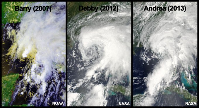
Interestingly, three recent examples of June Gulf of Mexico tropical storms affecting Florida all had the same, lopsided appearance this potential "Colin" may possess.
What do Florida June tropical cyclones look like? Big and messy. Here are the last three via satellite.
June Atlantic "C" Storms Are Rare
This hurricane season has already gotten off to a weird start.Hurricane Alex became only the second hurricane on record to form in the month of January, sweeping through The Azores as a tropical storm.
Over the Memorial Day weekend, Tropical Storm Bonnie brought flooding rainfall to parts of the Carolinas and Georgia, then had a "second wind" off the Outer Banks of North Carolina the following week.
This upcoming Gulf of Mexico disturbance would be named "Colin," if this system attains tropical storm-force sustained winds.
Getting to the "C" storm in the Atlantic name list in June is exceedingly rare.
Dating to the 1950s, when tropical cyclone name lists were first enacted, there have only been two other June Atlantic "C" storms:
- Hurricane Chris (first a "subtropical storm" on June 18, 2012)
- Tropical Storm Candy (briefly a tropical storm on June 23, 1968)
The only June Atlantic "C" storms I can find in the NOAA database. More "unnamed" June TCs prior to 1950s, though.
Colorado State University tropical meteorologist Dr. Phil Klotzbach says prior to naming storms, a June 12, 1887 tropical storm was the earliest in the entire period of record dating to 1851. However, Klotzbach notes that storms may have been missed in the historical record prior to the deployment of satellites in the 1960s.
Interestingly, in the record-setting 2005 hurricane season, Hurricane Cindy first became a tropical storm on July 5. That said, early-season (or pre-season) tropical cyclone activity has little bearing on the number or intensity of storms for the season as a whole.
Check back frequently for the latest on this potential Gulf of Mexico system.
(MORE: Are You #HurricaneStrong?)
Jonathan Erdman is a senior meteorologist at weather.com and has been an incurable weather geek since a tornado narrowly missed his childhood home in Wisconsin at age 7.


No comments:
Post a Comment