Published: November 15,2015
For the third time in less than a month, a threat of flash flooding looms in parts of Texas and Louisiana in the week ahead. This time, however, the flood threat will be much more expansive, extending north into the Mississippi and Ohio Valleys.

Upper-Level Pattern, Moisture Setup Wednesday
Ahead of an intense area of low pressure aloft sliding through the South in the week ahead, a plume of deep, tropical moisture will be tapped not just from the Gulf of Mexico, but also from the western Caribbean Sea and eastern Pacific Ocean south of southern Mexico's Coast.
This deep moisture is expected to eventually be pulled as far north as Hudson Bay, Canada, over 3,000 miles from its source region, quite anomalous by mid-late November standards. In fact, senior meteorologist Stu Ostro noticed well above-average atmospheric moisture values may extend to the North Pole thanks to this pattern.
By Tuesday or Wednesday, a measure of available moisture in the atmosphere known as precipitable water may reach record November levels in parts of the Great Lakes and Upper Midwest, including parts of Michigan, Wisconsin and Illinois.
Simply put, it will feel quite humid for mid-late November in these areas ahead of the aforementioned storm system.
While this intense upper-atmospheric low will likely not completely stall out, its eastward progression will be slow enough that, combined with the impressive moist plume ahead of it, excessive rainfall and localized flooding looks likely.
For now, the area of greatest concern for flooding rainfall in the week ahead lies from the Upper Texas and Louisiana Gulf Coasts into the Ozarks, lower to middle Mississippi Valley and lower Ohio Valley.

Flood Watches and Warnings
Flash flood watches have been issued for portions of southwestern and central Missouri, as well as much of Arkansas and eastern Oklahoma beginning Monday evening. Rain is likely in this area before the flash flood watch begins, but the heaviest rainfall is expected starting Monday evening.

Rainfall Potential Through Thursday
Much of this area has a strong potential of picking up at least 3 inches of total rainfall from this system in the week ahead.
(FORECAST: 7-Day Rain Maps)
This far out in time, it is not possible to delineate exactly where slow-moving bands of heavy rain and thunderstorms will stall out. Areas in these stalled rainbands will likely see much higher amounts, possibly over 6 inches, with rainfall rates of 1 to 2 inches per hour or higher.
The flood threat is particularly high in east Texas and Louisiana, where soil moisture remains extremely high following heavy rainfall and flooding in recent weeks.
Farther north, National Weather Service offices in the middle Mississippi and lower Ohio valleys have issued statements about excessive rainfall reaching the region in the coming days. The statements say that dry ground conditions are currently in place, however a threat of flooding is still expected given that soils will saturate with several inches of rain in the forecast.
(RECAPS: Late October "Patricia-Remnant" Deluge | Texas/Louisiana Flooding Ends October)
Here is the latest general flood threat timing outlook, which is subject to change in the days ahead.
- Monday night: Clusters
of thunderstorms with heavy rainfall in the southern and central Plains
from parts of north Texas to Kansas, extending east into the Ozarks,
mid-Mississippi Valley and Lower Ohio Valley.
- Tuesday: Heavy
rain and thunderstorms from eastern Texas and western Louisiana to
Arkansas, the mid-Mississippi (perhaps parts of the Upper Mississippi)
Valley and into portions of the Midwest.
- Wednesday: The
heavy rain threat slides east, extending from eastern Louisiana to the
Tennessee Valley, Ohio Valley and parts of the southern Great Lakes.
- Thursday: Pockets of locally heavy rain are possible along the front in the East, from New England to Florida.
Remember, never drive into flood waters of unknown depth or drive around barricades. Your vehicle may be the biggest danger in a flash flood. Turn around, don't drown.
(NOAA/NCEI)
Pouring It On
We mentioned earlier the twin flash flood events in late October in parts of Texas and Louisiana.(RECAPS: Late October "Patricia-Remnant" Deluge | Texas/Louisiana Flooding Ends October)
The Lone Star State had its fifth wettest October on record. Waco, Texas, and Baton Rouge, Louisiana had their record wettest October.
Here are some rather staggering one-month rainfall totals in parts of Texas and the Lower Mississippi Valley ending November 12:
- Baton Rouge, Louisiana: 17.55 inches
- Waco, Texas: 17.06 inches
- New Orleans: 13.83 inches
- Houston: 13.71 inches
- Jackson, Mississippi: 12.46 inches
- Shreveport, Louisiana: 11.08 inches
Despite a burgeoning late summer/early fall drought, January through October was among the top 10 wettest such periods in both Oklahoma and Texas, largely due to the epic rainfall in May, June and the twin October events.
January through October was the third wettest such period in the Lone Star State dating to 1895, and the wettest since 1941.
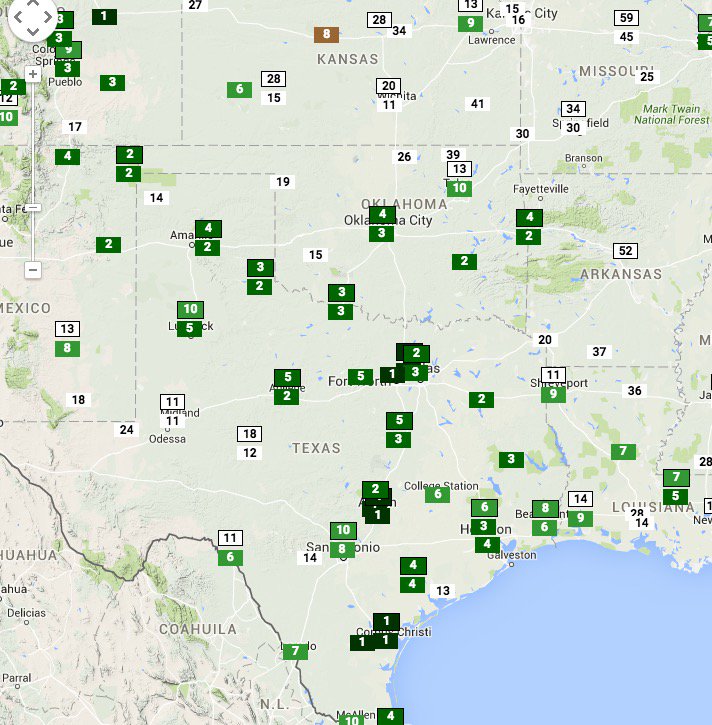
Dallas-Ft. Worth, Austin (Bergstrom Airport) and Corpus Christi, Texas, have each had their record wettest year-to-date through November 12, according to the Southeast Regional Climate Center.
Numerous other locations in the southern Plains, Lower Mississippi Valley and western Gulf Coast have also had one of their top 10 wettest years-to-date, including:
- Fort Smith, Arkansas: 4th wettest
- Houston: 6th wettest
- Baton Rouge, Louisiana: 7th wettest
- St. Louis: 7th wettest
Many locations already with a top 10 wettest YTD poised for more in the week ahead. (Rankings map: @SERCC).
Check back with us at weather.com for the latest on this potential flood event.
Jonathan Erdman is a meteorologist at weather.com and has been an incurable weather geek since a tornado narrowly missed his childhood home in Wisconsin at age 7. Follow him on Twitter and Google Plus.


No comments:
Post a Comment