July 4,2014; 9:16PM,EDT
As of 9:00 p.m. EDT Friday, this blog is no longer live. See reports below.
As the first Atlantic hurricane of the 2014 season, Arthur, will continue to bring heavy rain, rough surf, high winds and rip currents to areas along the Atlantic Coast of the United States.
On Thursday night, Arthur made landfall over the Shackleford Banks, which is located between Cape Lookout and Beaufort, North Carolina, as a Category 2 hurricane. As of Friday morning, the system weakened to a Category 1.
The worst impacts from Arthur will head to the mid-Atlantic and New England coasts through Friday night.
"Arthur will parallel the New England coast Friday night as it tracks toward another landfall in Nova Scotia Saturday morning," AccuWeather.com Meteorologist Andy Mussoline said. "The center of Arthur will narrowly miss New England, coming as close as 25 miles to Nantucket Island Friday night."
"Torrential, flooding rainfall and gusty winds on the northwestern flank of Arthur will hit eastern New England through Friday night."

RELATED:
Hurricane Arthur to Batter Eastern North Carolina
AccuWeather Hurricane Center
INFOGRAPHIC: Arthur to Disrupt East Coast July Fourth Festivities
UPDATES: (All times are listed in EDT)
7:43 p.m. EDT Friday: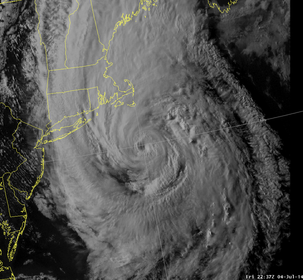
6:08 p.m. EDT Friday:


I live at a waterfront property #arthur
5:25 p.m. EDT Friday: "Torrential, flooding rainfall and gusty winds on the northwestern flank of Arthur will hit eastern New England through Friday night, AccuWeather.com Meteorologist Andy Mussoline said.

4:24 p.m. EDT Friday: Watch now for the latest updates on Arthur:
3:00 p.m. EDT Friday:
2:00 p.m. EDT Friday: North Carolina Department of Transportation continues the damage assessment, but reports Arthur has impacted several highways, according to the department's website.
 (Photo/ North Carolina Department of Transportation)
1:15 p.m. EDT Friday:
12:50 p.m. EDT Friday: Flash flooding reported across New London County, Connecticut. Law enforcement and fire and rescue workers report that the Pawcatuck River is over its banks in Clarks Village, and up to 4 feet of flood waters are washing over roads in Groton.
12:25 p.m. EDT Friday:
12:00 p.m. EDT Friday: Watch the latest edition of 'AccuWeather LIVE' with Meteorologists Andrew Baglini and Heather Waldman for more Arthur updates:
11:40 a.m. EDT Friday:
11:15 a.m. EDT Friday: Up to 3.35 inches of rain have been reported so far in Laurel, Delaware, by the Delaware Environmental Observing System.
10:45 a.m. EDT Friday: A buoy 7 miles from Fisherman's Island, Virginia, recorded a wind gust of 70 mph. Gusts are currently reaching as high as 105 mph.
10:30 a.m. EDT Friday: Flooding pours into Colington, North Carolina, this morning:
 (Instagram/saiward)
9:45 a.m. EDT Friday: Hurricane Arthur is currently churning about 130 miles east of Norfolk, Virginia.

9:10 a.m. EDT Friday: Arthur has weakened to a Category 1 hurricane.
9:00 a.m. EDT Friday: Low clouds hang over New York City as Hurricane Arthur continues tracking north:
 (Instagram/ebalutis)
8:40 a.m. EDT Friday: Observation site in Hatteras, North Carolina, reports 4.65 feet of surge on the sound side of the coast.
8:20 a.m. EDT Friday: Outer Banks resident Elvis Antonio Disla Pujols stated that nearly 5 feet of water have infiltrated his area:
 (Instagram/elviscocho30)
8:00 a.m. EDT Friday: Watch the latest edition of 'AccuWeather LIVE' with Meteorologists Heather Waldman and Mark Mancuso for the latest updates on Hurricane Arthur:
7:40 a.m. EDT Friday:


MT @SamWalkerOBX: US 64 from Manteo- Nags Head closed by flooding. Flooding in d'town Manteo #OBX #Arthur
7:20 a.m. EDT Friday:
5:50 a.m. EDT Friday:
5:27 a.m. EDT Friday:
5:15 a.m. EDT Friday: The eye of Hurricane Arthur has moved offshore. Rain and rough surf to continue for the East Coast.
4:25 a.m. EDT Friday:
4:02 a.m. EDT Friday: Arthur's eye will soon be back over the waters of the Atlantic Ocean.

3:00 a.m. EDT Friday: Video taken on the Outer Banks near Hatteras.
2:36 a.m. EDT Friday: Winds are howling at the Avalon Fishing Pier located along the Outer Banks as the eye of Arthur approaches.

1:40 a.m. EDT Friday: Sustained winds of 56 mph with a 99-mph wind gust at Ocracoke, North Carolina, according to Weather Flow.
1:05 a.m. EDT Friday: More than 21,000 Duke Energy Customers are without power in North Carolina, the utility reports.
12:37 a.m. EDT Friday:
12:29 a.m. EDT Friday:
12:04 a.m. EDT Friday: A wind gust of 88 mph was measured at Cedar Island, North Carolina, according to Mesonet.
11:30 p.m. EDT Thursday: Arthur has made landfall over the Shackleford Banks between Cape Lookout and Beaufort, North Carolina. Sustained winds at the time of landfall were 77 mph with a wind gust of 101 mph.
10:38 p.m. EDT Thursday: A wind gust of 87 mph was measured along the coast of North Carolina south of Morehead City, according to Weather Flow.
10:00 p.m. EDT Thursday: Arthur is getting closer to making landfall over North Carolina.

9:30 p.m. EDT Thursday:
9:15 p.m. EDT Thursday: Safety of the Herbert C. Bonner Bridge along North Carolina state highway 12 is a primary concern, reports North Carolina Department of Transportation officials, adding an inspection will occur after the storm.
9:10 p.m. EDT Thursday:
8:24 p.m. EDT Thursday:
8:00 p.m. EDT Thursday:
7:30 p.m. EDT Thursday:
7:21 p.m. EDT Thursday:
6:48 p.m. EDT Thursday: Watch 'AccuWeather Live' for the latest on Hurricane Arthur.
6:08 p.m. EDT Thursday:
6:05 p.m. EDT Thursday:
5:55 p.m. EDT Thursday:
5:45 p.m. EDT Thursday: More than 11,000 Duke Energy Customers without power, the
utility reports.
5:25 p.m. EDT Thursday:
4:45 p.m. EDT Thursday:
4:33 p.m. EDT Thursday:
3:43 p.m. EDT Thursday:
2:46 p.m. EDT Thursday:
1:50 p.m. EDT Thursday:
11:30 a.m. EDT Thursday: The St. Augustine, Florida, Life Guard Patrol reported 11 rip current rescues yesterday, as Arthur strengthened off the coast.
10:15 a.m. EDT Thursday: Storm clouds hover over Surf City, North Carolina, as Hurricane Arthur churns farther out in the Atlantic.
 (Photo/Town of Surf City)
8:00 a.m. EDT Thursday:This year is the first year since 1992 that the Boston Pops Fireworks Spectacular fireworks display has been rescheduled.
On Social Media

Hotpage
HOTPAGEinfo
Hurricane Arthur: Tropical Storm Warning As High Winds, Dangerous Flash Floods Lash Massachusetts @ hotpage.info

DisasterAWARE
disasteraware
[WARN] Upd Msg #17, Hurricane - Arthur, Atlantic Ocean, Winds 65 kt, Gusts 80 kt, reported by NWS. dynamic.pdc.org/snc/prod/46478

Sir. Kyle Gaskins
Kyle_TooTall
Lets
appreciate the perseverance of Eastern North Carolina to put on a great
fireworks display a day after getting hit by Hurricane Arthur
No comments:
Post a Comment