Published: December 21,2016
A strong low-pressure system will likely bring the threat of severe thunderstorms to portions of the central United States just in time for Christmas.
A southward dip in the jet stream, along with its associated surface low-pressure system, will push into the West Friday. This low-pressure system will intensify as it tracks east and is expected to move into the Plains on Christmas Day.
 Severe setup for Sunday.
(MORE: Winter Storm Europa To Bring Heavy Snow, Ice to Northern Plains, Midwest)
Thunderstorm Forecast
There is still uncertainty with the details of the forecast, but overall, there appears to be the threat of severe thunderstorms in parts of the central and southern Plains on Christmas as a cold front marches east.Some of the ingredients necessary for severe thunderstorms are expected to be in place, but one of the key questions is how much instability will be present. If there is more cloud cover and showers, along with cooler temperatures, the atmosphere would be more stable, limiting the potential for severe thunderstorms. Temperatures, though, are anticipated to be up to 20 degrees above average outside of storms and the extra heat should support storms.

Sunday's Forecast
- Forecast: Isolated severe thunderstorms may develop in the central Plains and portions of the southern Plains, mainly from Nebraska southward into north-central Texas.
- Threats: Damaging wind gusts will be the primary threat, but a few tornadoes are also possible.
One good thing about this system is the rainfall that is expected in parts of the South. Areas from northeastern Texas and eastern Oklahoma into Arkansas, Tennessee and western Kentucky will likely see the highest rainfall totals through Tuesday. These are areas that are experiencing drought conditions, so this rainfall is welcome.

Rainfall Forecast
Be sure to check back frequently for updates, as important details about this storm system could change.
Recent Tornadoes on Christmas
Severe weather on Christmas is not all that unusual, at least in the South.Just last year, deadly tornadoes and flooding impacted parts of the South and Midwest during the week of Christmas. According to The Weather Channel severe weather expert Dr. Greg Forbes, 67 tornadoes occurred from Dec. 23-28. Six of those tornadoes resulted in 24 deaths. Of the 67 tornadoes confirmed, two were rated EF4 and three were EF3. This was also the deadliest December since 1953.
On Christmas Day 2015, tornadoes were reported in Tennessee, Alabama and Mississippi. It was also the wettest Christmas on record in Birmingham, Alabama, Huntsville, Alabama, Knoxville, Tennessee, and Chattanooga, Tennessee.
(MORE: Tornadoes and Flooding Rain Hit the South, Midwest Christmas Week 2015 Recap)
 A house in the Midtown section of Mobile, Alabama, is damaged after a tornado touched down Tuesday, Dec. 25, 2012.
(AP Photo/AL.com, Mike Kittrell)
On Dec. 26, 2015, tornadoes were reported in Texas and Oklahoma. Tornadoes impacted the greater Dallas area, including an EF4 twister. An EF2 tornado killed two in Copeville, Texas, and one person died in Blue Ridge, Texas.
In 2012, the largest Christmas Day tornado outbreak on record occurred in the U.S. This outbreak was due to a southward dip in the jet stream and its associated surface low pressure that developed over southern Texas on Christmas morning. As this system, named Winter Storm Euclid, swept eastward, severe thunderstorms stretched from Texas to North Carolina Dec. 25-26.
According to Dr. Forbes, 30 tornadoes were confirmed on Christmas, including two EF3 tornadoes. One of the EF3 tornadoes lasted for 61 miles in Mississippi.
The reports of tornadoes on Christmas Day stretched from southeastern Texas through Louisiana, southern Mississippi and southern Alabama, including Mobile.
(MORE: Worst Christmas Weather)
Fortunately, no deaths were reported directly due to the tornadoes, although two people were killed by falling trees not associated with any of the tornadoes.
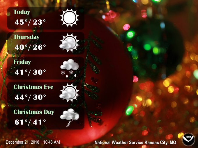
This year, however, thunderstorms are possible in some areas that don't normally see severe weather, or even thunder, this time of year; Kansas City is one example.
Just how rare is this forecast? Since 1970, thunder has only been observed once in #KC (1973) on #Christmas Day!
Snapped An Awesome Shot? Share Your Photo
If you crave pictures of severe weather, you've found your home here. Upload your photos or video (taking care to only take photos and videos from a safe location) to us and share your experience.(PHOTO/VIDEO GALLERIES: Severe | Storms)
MORE: Severe Weather in the South


No comments:
Post a Comment