Published: December 13,2016
After up to three feet of snow buried parts of the Great Lakes and Northeast states last week, the next round of significant lake-effect snow is just getting underway.
The coldest air mass of the season will engulf this region during the second half of the week, setting the stage for a multi-day siege of lake-effect snow.
(MORE: Back-to-Back Arctic Blasts Will Send Midwest, Northeast into a Deep Freeze Through the Weekend)
Lake-effect snow watches, warnings and advisories stretch from northeast Ohio and northwest Pennsylvania into upstate New York, east of Lakes Erie and Ontario. The Buffalo metro area is under a lake-effect snow warning, while Cleveland remains in a lake-effect snow watch for now.
A blizzard warning is in effect for the Keweenaw Peninsula of Upper Michigan due to strong, gusty winds creating frequent whiteout conditions. Winter storm watches and winter weather advisories have been posted for other portions of northern Michigan.

Current Winter Weather Alerts
Lake-Effect Snow Forecast and Impacts
Organized lake-effect snow is ongoing off Lakes Superior, Michigan and Huron. Significant snow will get going off Lakes Erie and Ontario Wednesday after a cold front pushes through the region, dropping the temperatures and shifting winds from a more westerly direction.Lakes Erie and Ontario will likely see the highest snowfall totals, due to the air picking up moisture from the western Great Lakes before reaching the eastern Great Lakes.
For example, Lake Huron and the Georgian Bay will help "feed" moisture to the snow bands that develop off Lakes Erie and Ontario due to the westerly to northwesterly prevailing winds.
Under this pattern, it's not uncommon to see snow totals over 30 inches on the Tug Hill Plateau in New York state, east of Lake Ontario. This is due to westerly winds blowing over the longest axis of the lake, as well as the upwind connection with the western Great Lakes. The gradual west-to-east rise in elevation on the plateau also plays a role.
(MORE: The Great Lakes' Amazing Lake-Effect Snowfall Records)

Snowfall Forecast
While Buffalo and Cleveland may pick up several inches of snow from this event, it appears the most significant, foot-plus accumulations will stay just south and east of those respective cities.
(FORECAST: Syracuse | Buffalo | Cleveland | Marquette, Michigan)
Strong wind gusts will lead to poor visibility due to blowing and drifting snow, as well as falling snow. Therefore, whiteout conditions are possible in the core of any lake-effect bands that develop this week.
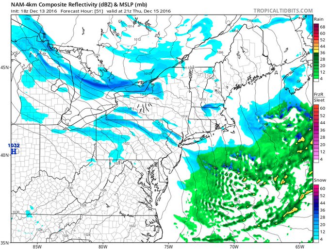
More interestingly, the strong winds could also carry some snow bands very far inland, potentially bringing flurries or even a brief snow shower to the Interstate 95 corridor.
Upper-level
shortwave could carry lake streamers all the way to North Jersey &
NYC Thursday afternoon. No big deal, just something to watch.
As high pressure builds across the Great Lakes and Northeast states on Friday, lake-effect snow will fade away, but the weather won't remain quiet for long.
Winter Storm Decima will impact the region by the weekend, bringing more accumulating snow. For more details on that, click the link below.
(MORE: Another Cross-Country Snowstorm)
Setup for Multi-Day Lake-Effect Siege
An upper-level area of low pressure will set up south of the Hudson Bay in Canada into Thursday, spinning frigid westerly to northwesterly winds across the warm Great Lakes – by December standards.Lake temperatures are still in the 40s, and the air mass will be so cold that intense snow bands will develop, potentially dumping feet of snow, especially east of Lake Ontario, where the bitterly cold air will have the longest fetch, or path of the air across the lake.
(MORE: The Science Behind Lake-Effect Snow)

Since lake temperatures are in the 40s, the minus-20-degree air temperatures at 5,000 feet will exceed the temperature difference required for the formation of lake-effect snow.


No comments:
Post a Comment