Tom Moore
Published: September 22,2016
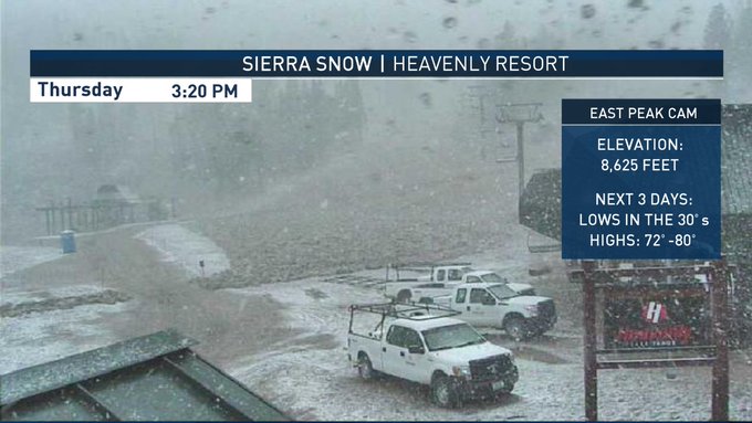
An early season storm system in the Rockies will celebrate autumn's arrival in appropriate fashion.Rain will change to snow into Friday morning across higher elevations of Idaho, Nevada and Utah.
Its nice to see weather systems trending cooler now to support Sierra snow. Keep in mind, 70s-80s highs return this weekend. #FirstDayofFall
Snow will spread eastward to Montana, Wyoming and Colorado on Friday night and Saturday.
Meanwhile, rain and thunderstorms will spread to the Plains on Friday and Saturday.

Radar, Watches and Warnings
Storm Timing and Impacts

Rainfall Forecast Through Saturday
As cold air moves in behind the front, rain will change to snow on Thursday night in the higher elevations of eastern Nevada, Idaho, southwestern Montana, western Wyoming and along the Wasatch Range of Utah. Snow levels will be generally around 7,000 feet but could dip below 6,000 feet in a few locations.
Friday
An area of low pressure and an associated cold front are moving eastward from the Intermountain West into the northern Plains.
Rain and thunderstorms will develop ahead of the cold front from northern New Mexico through central Colorado to eastern sections of Wyoming and Montana. The heaviest rainfall totals will likely be across eastern Montana, where 1 to 2 inches are expected. Localized flooding will remain a problem, especially in parts of Montana.
By Friday afternoon, thunderstorm activity will increase across the Dakotas and western Nebraska as a southerly wind flow increases and a cold front approaches. Meanwhile, rain and higher-elevation snow will wrap around the low-pressure system back to western Montana, Idaho and Utah. Accumulating snow will generally be above 7,000 feet.

Friday's Thunderstorm Forecast
Weekend
Thunderstorms with locally heavy rain will be present across North Dakota on Saturday. Rainfall totals up to 3 inches (with locally heavier amounts) are possible in the western part of the state. Meanwhile, scattered thunderstorms will develop down through the Plains as a cold front advances eastward.
A few thunderstorms could approach severe limits, with strong wind gusts from western Minnesota to the southern Plains on Saturday.

Saturday's Thunderstorm Forecast
The threat of thunderstorms will remain in the southern Plains on Sunday. There could also be heavy rain from southern Kansas to northern Texas (some locations could see over 3 inches) along with localized flooding.
All told, the higher elevations of southwest Montana, northwest Wyoming and northern Utah could see 8 to 12 inches of snow, mainly above 8,000 feet, from this storm.
Lighter amounts will fall between 7,000 and 8,000 feet. Parts of Idaho, Nevada and northern Colorado could see from 3 to 5 inches of snow at elevations above 8,000 feet, and lower amounts between 7,000 and 8,000 feet.

Snowfall Forecast Through Saturday
Setup For Early Fall Storm

Late Week Jet Stream Forecast
This will allow a low-pressure system to rapidly develop at the surface into Friday.
(MORE: How Temperatures Daylight 'Fall' From Late September to Late December)
The trough will also pull tropical moisture northward into the Intermountain West and the western Plains (a remnant of Tropical Storm Paine). This will help to enhance overall precipitation from this storm and increase the chances for flash flooding.
At the surface, cold air will move rapidly into the region, setting the stage for lower elevation rain and thunderstorms along with higher elevation snow.
It will be too warm to snow across the Plains as we move into the weekend, but there will be plenty of rain and thunderstorms.
MORE: Rocky Mountain Snowfall


No comments:
Post a Comment