Newton's center of circulation has crossed into southern Arizona, and will continue to spread rain into parts of the Southwest U.S. into Wednesday evening.
Newton
weakened to a post-tropical cyclone before crossing the border into
Arizona. The last tropical cyclone to reach Arizona as a tropical storm
was Tropical Storm Nora in 1997.
(MORE: Hurricane Central)
Current Storm Status

Latest Radar, Warnings
As of Wednesday afternoon, the heaviest rain has fallen over Pima County and Cochise County in southern Arizona. Miller Carr Canyon has picked up 4.68 inches of rain, and an observer 4 miles southwest of Tucson has measured 4.38 inches of rain.
A couple of high elevation locations in southern Arizona have recorded wind gusts over 50 mph, including 68 mph at Hopkins (elevation 7,120 feet) and 58 mph at Miracle Valley (elevation 7,677 feet). Winds have been much lower than this in the lower elevations.

Rainfall Through Thursday
Fortunately, this will be a relatively short-lived heavy rain threat in the Southwest, fizzling quickly by Thursday.
(FORECAST: Tucson, Arizona)
Flash flood watches are in effect for the southeastern quarter of Arizona and a swath of western New Mexico.

Flood Alerts
Newton's History
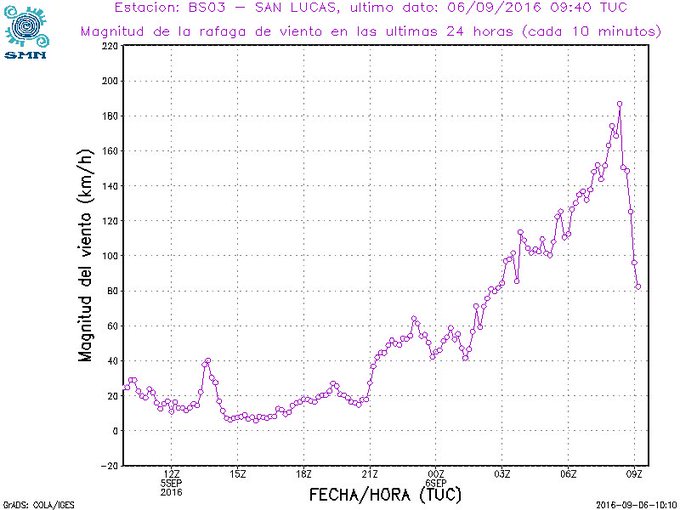
Newton rapidly intensified after becoming Tropical Depression Fifteen-E on September 4 to a Category 1 hurricane just 24 hours later.Newton then made landfall in Cabo San Lucas about 12 hours later as a high-end Category 1 hurricane.
De acuerdo a la estacion Smn de Cabo Sn Lucas Bcs con #Newton la ráfaga de viento fue de 185km/h
(RECAPS: Hurricane Odile | Remnant Moisture Triggered U.S. Flooding)
Hurricane Newton then moved up the southern Baja California peninsula Tuesday. Loreto, Mexico, reported a peak wind gust to 89 mph and 3.78 inches of rain in 24 hours ending early Wednesday morning.
Newton then made its final landfall in northwest Mexico's Sonora state near the town of Bahia Kino as a tropical storm.
Here are some peak wind gusts measured during and after this final landfall, according to NHC:
- 66 mph: Guaymas, Mexico
- 64 mph: East of Bahia Kino
- 50 mph: Hermosillo International Airport


No comments:
Post a Comment