Tuesday, November 1, 2016

Relentless heat to aggravate Southeast drought as rain remains absent

By Brian Thompson, Meteorologist
November 1,2016; 10:03PM,EDT
 
 
No rain is in sight for most of the Southeast through the first few days of November, thanks to a persistent warm and dry pattern.
A northward bulge in the jet stream, which is responsible for the warmth, will hold through the middle of the week. The jet stream is a fast river of air high in the atmosphere that storm systems which carry rain move along.
The ongoing stretch of warmth and dryness in the region will spell bad news for the worsening drought.
Cities such as Pensacola, Florida, as well as Birmingham and Mobile, Alabama, ended up with no measurable precipitation during the month of October.

The dry weather has been accompanied by record-breaking warmth.
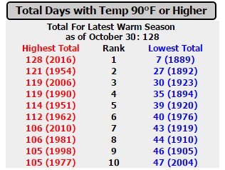
Atlanta has likely set a new record for the warmest September through October period, on the heels of the city's second warmest summer.
This chart displays stats through Oct. 31, 2016.
"The abnormal warmth contributes to more moisture evaporating out of the soil. When the moisture does not get replenished, it's like a vicious cycle," AccuWeather Meteorologist Mike Doll said.
Birmingham, Alabama, has not received measurable rainfall since Sept. 18.
The city only received 0.68 of an inch of rain for the months of September and October, combined. That is just 9 percent of what Birmingham typically receives over the two-month span.

According to the U.S. Drought Monitor, over 73 percent of Alabama is experiencing severe to exceptional drought conditions.
Mississippi has not fared much better. Both Jackson and Tupelo have recorded just 12 percent of what each city receives in September and October.
Drought areas across the state are affecting over 2.9 million people, U.S. Drought Monitor data reveals.
RELATED:
US winter forecast: Freeze may damage citrus crop in South
5 weather threats to be wary of during the fall
1 dead, 5 injured after pipeline explosion in Alabama

This persistent dry weather is not predicted to end anytime soon.
"Unfortunately, the jet stream pattern this week will continue to guide storm systems and moisture north of the Southeast region," Doll said.
With rainfall deficits growing deeper, several storm systems producing heavy rain will be necessary to put a significant dent in the building drought.
According to Doll, a pattern like this is not expected to materialize over the next couple of weeks.

India, Bangladesh on alert as potential tropical system brews

By Eric Leister, Meteorologist
November 1,2016; 10:32PM,EDT
 
 
A system near the Andaman and Nicobar islands will move westward across the Bay of Bengal and could become a named tropical cyclone in the coming days.
Areas from eastern India to Bangladesh should be on alert for potential impacts from this developing cyclone.
While a named cyclone is possible as early as Wednesday, impacts to land are not expected until Thursday afternoon at the earliest.

Gradual strengthening is expected through at least Friday as the storm approaches India.
Rain bands from the strengthening tropical system could lash areas from Kakinada to Kolkata on Thursday afternoon. However, any major impacts are not expected until Friday and the weekend.
A general west-northwest track is expected through Thursday keeping the potential cyclone over the open Bay of Bengal.
RELATED:
Indian Ocean Tropical Center
Detailed forecast for Kolkata, India
Asia winter forecast: Smog to endanger lives in India, Pakistan

A turn toward the north is forecast on Friday before a northeasterly turn over the weekend.
This track will likely keep the cyclone from making landfall until late Saturday or Sunday.
The most likely area to endure a direct landfall from the cyclone at this time is northeastern India and Bangladesh.
Residents of Kolkata and Dhaka would monitor this potential cyclone closely in the coming days and be prepared for possible impacts.
Potential impacts from this tropical threat include flooding, damaging winds, coastal storm surge and dangerous seas.

Election Day 2016: Dry weather to favor high voter turnout across much of US; Rain to dampen Central states

By , AccuWeather.com Senior Meteorologist
November 1,2016; 9:43PM,EDT
 
 
While downpours may deter some voters in part of the central United States, tranquil weather over much of the nation may help boost voter turnout among some demographics on Election Day 2016.
No significant snow is forecast to fall over the lower 48 states on Election Day on Tuesday, Nov. 8.
A lack of extreme weather conditions is forecast across the nation. However, there will be a swath of downpours some voters will have to contend with when heading to the polls.
"Weather was found to be, on average, nearly 20 percent of the change in voter turnout based on our analysis," according to AccuWeather Business Intelligence Manger and Meteorologist Tim Loftus.
Loftus utilized L2 as a resource when conducting research, which included analyzing weather trends and voter data to primary elections dating as far back as 1996. According to the research, weather does impact how some voters respond when making a decision to head to the polls.
"While the data is based on the primary elections, we would expect similar behavior during the national elections in November," Loftus said.
RELATED:
US winter forecast
5 weather threats to be wary of during the fall
Check AccuWeather MinuteCast® for your location

"Democrats are more weather-sensitive, when compared to Republicans and among the most weather-sensitive were African-Americans, those 65 and older and 18- to 24-year-olds," Loftus said.
Early next week, a storm system will push slowly eastward across the Plains and toward the Mississippi Valley.
The forward speed of this storm will determine where rain arrives and where the weather clears for Election Day over the Central states.

While the storm does not appear to be very strong, there will be the potential for downpours to cause travel delays over part of the South Central states. People heading to the polls where long lines are common will want to take along an umbrella.
The most likely locations for locally heavy rain will extend from central and eastern Texas, Oklahoma and Kansas to portions of Louisiana, Arkansas and Missouri. Cities that could be impacted by downpours include Dallas; Houston; Oklahoma City; Little Rock, Arkansas; and Kansas City, Missouri.
"In Texas, most voters tend to hit the polls when rainfall precedes elections, while in Oklahoma, rainfall topping 0.5 of an inch and rain over a three-hour period or longer had a negative impact on turnout," Loftus said.
Less intense showers may extend as far to the north as Minnesota and Wisconsin.
A chance of showers may also exist in coastal locations of Washington and Oregon, which is quite common for early November. Very spotty showers could dot the Atlantic coast counties of Florida during the morning.
The vast majority of the eastern third and western half of the nation can expect dry weather and sunshine on Election Day.
"People in most of the East and West will not have to wait outside in inclement weather to vote," according to AccuWeather Meteorologist Eric Leister.
Voters wait in line at a weekend early voting polling place at the North Hollywood branch library in Los Angeles Sunday, Oct. 30,2016. Los Angeles County election officials say some voters waited more than two hours to cast a ballot amid strong interest in early voting. (AP Photo/Reed Saxon)
Dry and warm conditions could help boost voter turnout in some demographics over much of the South and West.
When it comes to the weather's impact on voter turnout, according to AccuWeather Business Intelligence Manager Rosemary Radich, it is usually the air temperature that influences people's decision of whether to head to the polls or not, rather than precipitation.
"In some Southern states, such as Florida and Georgia, sunny and warm conditions will tend to bring more younger voters out to the polls," Loftus said.
In the southern half of the nation, highs will be mainly in the 70s F with 80-degree temperatures likely along much of the Gulf coast, including Tampa, New Orleans and Houston, and southern Arizona, including the Phoenix area. People waiting outside to vote in these areas may want to bring along a bottle of water.
Elsewhere, highs will be within a few degrees of 70 in San Francisco and well into the 70s around Los Angeles, Dallas and Atlanta.
Meanwhile, people waiting in line in the morning will need some light layers of clothing, including a jacket, from Maine to New Jersey, Pennsylvania, Ohio and Michigan. However, while it will be cooler, when compared to much of the autumn thus far, it should be far from extreme chill for this time of the year.
Temperatures in most locations to start the day from the Upper Midwest to the Northeast are forecast to be in the 30s and 40s. Highs will range from the lower 50s around Boston, the middle 50s in New York City and the lower 60s around Washington, D.C.
"When it comes to overall voter turnout, it really depends on a variety of factors, including the enthusiasm level for the candidates, how close the race is and the individual's campaign success," Radich said.
If people are passionate enough about the outcome of the election, most will still go out and vote regardless of the weather conditions, according to Radich. This is especially so if the weather is not extreme.

1 dead, 5 injured after pipeline explosion in Alabama

By Kevin Byrne, AccuWeather.com Staff Writer
November 1,2016; 5:46AM,EDT
 
 
One person was killed and at least five others injured Monday after an explosion on a gas pipeline in Helena, Alabama, the Associated Press reported.
The explosion on the Colonial Pipeline happened just one mile west of where a gas leak occurred on the pipeline in early September, according to Alabama Gov. Robert Bentley.
The injured workers were taken to Birmingham hospitals, Bentley told WBRC-TV Monday evening. Bentley added that the blast appears to have been an accident.
According to the AP, Colonial Pipeline issued a brief statement saying it has shut down the main pipeline.
"Colonial's top priorities are the health and safety of the work crew on site and protection of the public," the company said.
The pipeline could reopen as soon as Saturday, Reuters reported.
RELATED:
Top weather phobias explored: Millions of Americans experience these weather fears
Italy's strongest earthquake in over 30 years leaves 15,000 homeless
Relentless heat to aggravate Southeast drought as rain remains absent

A large plume of flame and smoke was being shown arising from the area. The Alabama Emergency Management Agency said a temporary flight restriction is in effect for the area around the explosion.
An area 3 miles around the fire has been evacuated, Bentley said in a statement.
Firefighters work to put out a fire after part of the Colonial Pipeline exploded in Helena, Alabama. (Photo/Alabama Emergency Management Agency)
Helena is located about 20 miles to the south of Birmingham.
It is not particularly windy in the area with winds out of the southwest around 5 mph, according to AccuWeather Meteorologist Alyson Hoegg. Winds will remain light into the overnight hours but will shift to the southeast, she added.
The pipeline explosion occurs at a time while much of the Southeast continues to face stifling heat and continued periods of dry weather. Birmingham tied or broke a record high six times during October and is likely to end up with no measurable precipitation for the month.
There have been more 1,000 wildfires in the state state since Oct. 1, according to the Alabama Forestry Commission (AFC).
Two wildfires ignited as a result of the explosion and burned 31 acres of land according to the AFC. The fires have been contained. The commission also said that workers built a 75-80 foot earthen dam, which is approximately 7-8 feet tall. This was done to contain burning fuel until it burns itself out.
(Photo/Twitter user @Kdudley_)
A fog of smoke covers the trees near an explosion of a Colonial Pipeline, Tuesday, Nov. 1, 2016, in Helena, Ala. (AP Photo/Brynn Anderson)

National Temperature and Rainfall Extremes for November 1,2016 from accuweather.com

As of 12:30AM,EDT/9:30PM,PDT


Daily U.S. Extremes

past 24 hours

  Extreme Location
High 98° McAllen, TX
Low 13° Bodie State Park, CA
Precip 0.79" Bremerton, WA

World Weather Hot Spot for November 1-2,2016 from accuweather.com

Hatnah,Vietnam: Very heavy rain;received a whopping 6.77 inches of rain on Monday (October 31,2016)

WeatherWhys for November 1,2016 from accuweather.com

November days tend to be darker. The reason for this is the combination of cloudier days and a low sun angle, which causes more light to be reflected out to space.

National Temperature and Rainfall Extremes for October 31,2016 from accuweather.com

As of 10AM,EDT/7AM,PDT,November 1,2016:


Daily U.S. Extremes

past 24 hours

  Extreme Location
High 93° McAllen, TX
Low 13° Bodie State Park, CA
Precip 1.12" Olympia, WA

Halloween Surprise: Rare Tropical Storm Forms in Mediterranean Sea

Jon Erdman
Published: October 31,2016

A tropical storm formed Halloween weekend, not in the typical Atlantic or Pacific, but in the Mediterranean Sea.
This rather strange sequence of events began as an area of low-pressure dropped southward from southern Europe and became temporarily left behind by the jet stream over the central Mediterranean Sea south of the Italian coast.
(MORE: The 35 Strangest Weather Events I've Seen in My Lifetime)
By Saturday, Oct. 29, a non-tropical low pressure center formed east of Malta, a group of islands between Sicily and the coast of Libya over the weekend.
RGB composite satellite image of the Mediterranean storm as it was making the transition to a subtropical storm on October 30, 2016, at 12:00 UTC.
(NERC Satellite Receiving Station, University of Dundee)
The next day, thunderstorms became more clustered near the low-pressure center to warm the mid levels of the atmosphere sufficiently to morph the system into a subtropical storm.
A subtropical storm displays features of both tropical and non-tropical systems, including a broad wind field, no cold or warm fronts, and generally low-topped thunderstorms displaced from the center of the system.
(WUNDERBLOG: What are Subtropical Storms?)
Infrared satellite loop of the Mediterranean subtropical, then tropical storm on Oct. 30-31, 2016.
Soon after, the clusters of storms became even more tightly concentrated, and the atmosphere warm enough that this low actually became a tropical storm.
(IMAGES: The Most Iconic Hurricane Images of All Time)
High-resolution visible image from the Suomi NPP satellite of the Mediterranean Sea tropical cyclone on October 30, 2016.
(NASA Worldview)
This Mediterranean tropical storm, known as invest 90M, wasn't nearly the powerhouse deep tropical cyclone you would see in the tropical Atlantic or Pacific basins.
Its warm air was relatively shallow, but there, according to an analysis from Florida State University.
Phase-space diagram for the Mediterrean storm from Oct. 29-31, 2016. The black trace indicates the vertical, thermal structure of the storm. The analysis shows the low spent time both as a tropical and subtropical cyclone (annotations added).
This storm whipped up impressive waves on the coast of Malta.
By later on Oct. 31, the tropical storm was finally whipped eastward by an arriving jet stream, becoming a non-tropical low again as it brushed southern Greece and Crete.

Are 'Medicanes' Real Hurricanes?

In the meteorological community, there is some debate whether past vigorous low-pressure centers over the Mediterranean Sea were truly tropical cyclones, or a combination of a tropical and more typical mid-latitude low-pressure center, known as a subtropical cyclone.
In fact, they can become strong enough to be considered Mediterranean hurricanes, or "Medicanes". They can form in late summer or fall and also in winter and early spring.
One argument for "Medicanes" is the appearance of some recent storms via satellite resembling small hurricanes, including an eye.
The most vivid recent example of this was in January 1995. National Hurricane Center senior hurricane specialist Dr. Jack Beven chronicled this impressive storm, including satellite imagery.
In early November 2011, another low over the Mediterranean Sea appeared to transition to at least a subtropical storm, if not a tropical storm. NOAA/NESDIS designated this tropical storm 01M, also Rolf, on Nov. 7.
(MORE: Strangest Locations Hurricanes Have Formed)
Infrared satellite image of the Nov. 2011 tropical storm in the Mediterranean Sea off the French Riviera.
(EUMETSAT)
Weather Underground's Dr. Jeff Masters, however, notes that water temperatures near the cyclone were cold, about 63 degrees Fahrenheit (17C), well below the typical threshold needed to maintain a tropical cyclone, which usually about 79 degrees.
Nevertheless, the storm made landfall in southeast France, produced up to 2 feet of rain, triggered major flooding in parts of France, Spain and Italy. Twelve were killed.
With the storm over the weekend, surface water temperatures were much warmer, around 24 degrees Celsius, but still generally cooler than what typically supports tropical cyclone formation in the Atlantic Basin.
Sea-surface temperature analysis on October 30, 2016. The area of the Halloween 2016 Mediterranean tropical storm is boxed in red at left.
(NOAA/ESRL/PSD)
In a warming world, could Medicanes become more common?
Masters' blog cites a 2007 study by Gaertner et al., purporting hurricanes could form in the Mediterranean Sea if sea-surface temperatures rose by 3 degrees Celsius by 2100.
Masters also points out three main barriers to strong medicanes in the future:
  • The jet stream still typically dips southward over the Mediterranean Sea quite often, given its northern latitude.
  • The key to tropical cyclone formation in other basins is the depth of warm water available, not just warmth at the surface. The Mediterranean Sea is not supplied with deep, warm water like the western Atlantic Ocean is from the Gulf Stream.
  • Various island and land masses jutting out (Italy, Sicily, Corsica, Sardinia, Greece) would disrupt the circulation.
Don't worry about buying hurricane insurance for your Mediterranean cruise yet.
Jonathan Erdman is a senior meteorologist at weather.com and has been an incurable weather geek since a tornado narrowly missed his childhood home in Wisconsin at age 7.

It Hasn't Rained Since Hurricane Matthew in the Flood-Ravaged Carolinas

Brian Donegan
Published: October 31,2016

Hurricane Matthew paralleled the Southeast coast Oct. 6-9, dumping over a foot of rain from parts of Georgia to the Carolinas and southeastern Virginia, along with deadly storm-surge flooding and damaging wind gusts. In the three weeks since, it hasn't rained in much of the Southeast.
Not that one would want a deluge to trigger flooding in a drought, but the rain from Matthew didn't exactly overlap well with the rapidly worsening drought area in the Tennessee Valley, just to the west.
(MORE: Hurricane Matthew Recap)
Estimated rainfall from Matthew.
As of the latest U.S. Drought Monitor, released last Tuesday, nearly 40 percent of the Southeast was classified in a moderate to exceptional drought, with moderate being the lowest drought classification and exceptional being the highest.
A broad swath of the interior Southeast has received less than 15 inches of rain since May 1, translating to rainfall amounts of 5 to 15 degrees below average during the six-month period.
Drought conditions across the Southeast as of Oct. 25, 2016 (data from U.S. Drought Monitor).
There are at least 17 cities currently experiencing a top-three driest May-October on record, including Chattanooga, Tennessee, Columbus, Georgia, and Macon, Georgia. In fact, Chattanooga is currently more than 14 inches of rain below average over the last six months.
(MORE: South May Not See Much Relief from Drought This Winter)
Although 40 percent of the Southeast seems like a high amount to be under drought conditions, if it weren't for Hurricane Matthew at the beginning of October, the drought would likely be more widespread due to the lack of rain since then.
As fall progresses, the drought may continue to worsen based on current long-range outlooks, and it doesn't help that fall is also the driest season of the year climatologically.
(MORE: November Outlook)
The Southeast relies on spring and summer thunderstorms, as well as tropical systems, in the summer and early fall to pick up rainfall. Thunderstorm season, for the most part, has come to an end, and hurricane season officially ends Nov. 30.
November precipitation outlook from The Weather Company, an IBM Business.
Based on the November precipitation outlook above from The Weather Company, an IBM Business, it is unlikely to see much, if any, improvement to the Southeast's drought conditions over the next month. Chances of rain will be few and far between.
On the other hand, this dry spell has allowed coastal areas of the Southeast to dry out after Matthew ravaged the area in early October.
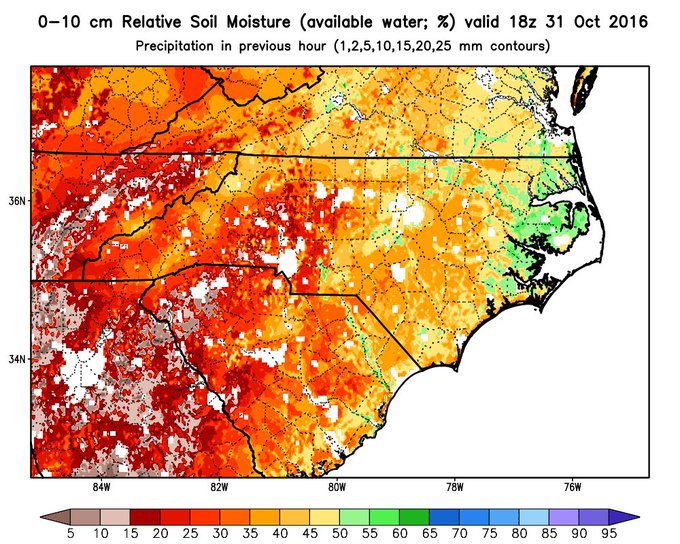
With 3+ weeks of no rain, you can see the soils are drying out across Southeast NC and Northeast SC, nothing like the western Carolinas.

World Series Game 6 Likely to Set Weather Record in Cleveland Tonight

Jon Erdman
Published: November 1,2016

A surreal 2016 World Series, featuring two cold-climate cities starving for their first baseball championship since the early 20th century, now shifts back to Cleveland.
Usually the words "November" and "Cleveland" elicit thoughts of cold, windy weather. But, for games 6 and 7 of the World Series, it will feel like September baseball, instead.

Game 6 - Tuesday Night

A warm front will surge well north of the Buckeye State Tuesday.
Fortunately, the trailing frontal boundary in the Great Lakes will be mainly dry Tuesday, so the bottom line for the game itself is warm and breezy conditions.
(FORECAST: Cleveland)

Game 6 First-Pitch Forecast
The forecast calls for southerly winds and evening (game-time) temperatures in the upper 60s to near 70 degrees.
According to The Weather Channel meteorologist Adam Dean, these temperatures would easily eclipse the previous record warmest northern November Major League Baseball game, from the 2001 World Series in the Bronx.
These are evening temperatures more typical of a mid-September game at Progressive Field, rather than early November, when you would expect evening temperatures in the upper 40s or low 50s.

Game 7 Outlook - Wednesday Night

If the Chicago Cubs win game 6, weather for game 7 gets a bit more interesting.
The aforementioned trailing frontal boundary gets energized as it sags to the south.
It will still remain north and west of Cleveland through Wednesday night, so the best chance of rain should also remain near that boundary, rather than over Cleveland, during the game.

Game 7 First-Pitch Forecast
That said, we still cannot completely rule out a brief shower. However, it should be nothing that raises too much concern for the game and the greatest chance of rain in Cleveland will likely be after the game ends.
It will remain mild as well with temperatures in the 60s during the evening.
The only World Series game in league history to be suspended due to rain was Game 5 of the 2008 World Series between the Tampa Bay Rays and Philadelphia Phillies, when the combination of rain and wind in Philadelphia forced the Oct. 27 game to be completed two days later.
Coincidentally, current Cubs manager Joe Maddon was skipper of the Rays in that series eight years ago.
Incidentally, the coldest World Series game of the last 40 years was on Oct. 22, 1997, in Cleveland, with a game-time temperature of 38 degrees, wind chills in the upper teens and flurries falling during the game.
Check back with us at weather.com for the latest updates on the World Series weather forecast.

MORE: 50 Places For Fall Colors

Fall Heat Wave Will Smash Records Into the First Days of November

Chris Dolce
Published: November 1,2016

November will kickoff with summer-like heat, shattering hundreds of daily records, and also threatening all-time November records in parts of the heat-weary South and Plains states.
Dozens of daily record highs were broken Monday, making it the hottest Halloween on record in those cities.
Among those, at least four cities set their hottest temperatures so late in the season, including Atlanta (86 degrees), Huntsville, Alabama (88 degrees), Muscle Shoals, Alabaman (88 degrees), and Tallahassee, Florida (90 degrees).
A number of other cities reached 90 degrees on Halloween, including Colby, Kansas, Dodge City, Kansas, Garden City, Kansas, Hattiesburg, Mississippi, Meridian, Mississippi, Montgomery, Alabama, Albany, Georgia, and Macon, Georgia.
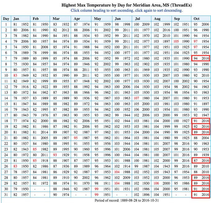
Meridian, Mississippi, has arguably been an epicenter city for this heat wave, reaching 91 degrees on back-to-back days October 30 and 31.
Meridian, MS, arguably the October epicenter. 9 daily record highs. 4 straight to end the month. Nov. rec. (87˚) in jeopardy.

Other Halloween daily records tied or set included Colorado Springs (80 degrees), Nashville, Tennessee (85 degrees), New Orleans (89 degrees), Jacksonville, Florida (86 degrees), Savannah, Georgia (87 degrees), and Amarillo, Texas (87 degrees).

Current Temperatures
Some southern cities could set a new daily record high each day for the next few days.
This continues what has been a much warmer-than-average month for the vast majority of Americans east of the Rockies, including a mid-October warm spell that shattered records.
Below are details on the forecast temperatures through Thursday, along with perspective on how warm this October was.

Tuesday's Forecast


Forecast Highs Compared to Average Tuesday
  • Highs 10 to 25 degrees above average will surge back into the Great Lakes, Ohio Valley and Appalachians, while continuing to encompass much of the Plains and South.
  • 70s are possible as far north as southern Wisconsin, Lower Michigan and western New York.
  • 80s will once again rule the Ohio Valley and South.
  • A few 90s are possible in the Deep South.
  • Record highs will again likely be numerous from the Southeast to the Ohio Valley and in parts of the Plains, threatening some all-time November record highs in some areas.
  • Potential all-time November record highs (record to beat is shown): Amarillo, Texas (87 degrees); Cincinnati, Ohio (81 degrees); Louisville, Kentucky (84 degrees); Nashville, Tennessee (85 degrees)
(MORE: La Nina May Limit Drought Relief in the South This Winter)

Wednesday's Forecast


Forecast Highs Compared to Average Wednesday
  • Highs 10-25 degrees above average will spread into parts of the Northeast, while also continuing in much of the Midwest and South. 
  • 70s are expected in the southern Great Lakes, Ohio Valley and mid-Atlantic states.
  • 80s will dominate the Southeast and southern Plains, though it won't be quite as warm as previous days.
  • Numerous daily record highs will again be within reach in the Southeast and Ohio Valley.

Thursday's Forecast


Forecast Highs Compared to Average Thursday
  • Highs 10-20 degrees above average will continue in much of the South and East, and a new surge of such warm air will intensify in the northern Plains.
  • 70s willl surge as far north as southern New England, though part of the interior Northeast and northern New England will be cooler.
  • 80s will once again dominate the Southeast and Deep South, though cooler temperatures will plunge into parts of the southern Plains.
  • Daily record highs will be within reach in parts of the Southeast and mid-Atlantic states.

Heat Wave Recap

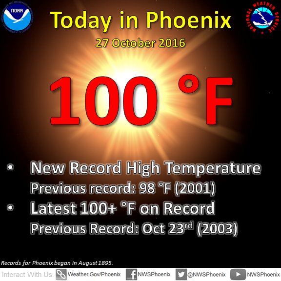
Thursday, October 27, Phoenix smashed their record latest-in-season 100-degree high by four days.
Sorry everyone, we've hit 100 (so far).

Other record highs were tied or set Thursday in Denver (83 degrees), Salt Lake City (78 degrees) and Tucson, Arizona (97 degrees).
Friday, October 28, record highs were shattered in Garden City, Kansas (91 degrees - old record was 83), and Dodge City, Kansas (92 degrees - old record was 85) and new records were set in Amarillo, Texas (87 degrees), Pueblo, Colorado (87 degrees) and Meridian, Mississippi (89 degrees).
Friday was the fifth daily record high this month in Meridian, and was their hottest temperature so late in the season. Previously, the latest they reached 89 degrees was October 26, 2010. This is their average high on September 8.
Daily record high temperatures were toppled in many cities on Saturday. Among them were Huntsville, Alabama (88 degrees), and Amarillo, Texas (91 degrees), which both saw their warmest temperature so late in the calendar year.
Daily record highs were also set Saturday in Asheville, North Carolina (81 degrees), Blacksburg, Virginia (79 degrees), Nashville, Tennessee (86 degrees), Tupelo, Mississippi (89 degrees), St. Louis, Missouri (86 degrees), and Phoenix, Arizona (96 degrees).
Numerous daily record highs were broken Sunday. Atlanta's record high of 86 degrees was the latest 86-degree day on record there, surpassing the previous date of Oct. 28, 1940.
Meridian, Mississippi, hit 90 degrees Sunday, the latest such reading on record, there, beating the previous record by a full week (Oct. 23, 1941), not to mention adding to a new yearly record of 90-degree-plus days, there.
View image on Twitter
Including today, the temperature has reached 90°F on 128 days so far this year at Meridian - also easily a record.

Other daily records were tied or set Sunday in Birmingham, Alabama (87 degrees), Knoxville, Tennessee (83 degrees), New Orleans (87 degrees), Austin, Texas (88 degrees), Washington D.C.'s Dulles Airport (84 degrees), Harrisburg, Pennsylvania (81 degrees), and Atlantic City, New Jersey (80 degrees).

How Warm It's Been

Many locations in the central and eastern United States experienced a very warm October.
Temperatures compared to average Oct. 1-24, 2016. Areas shaded orange and brown have seen temperatures the farthest above average overall.
(Oregon State University Prism Climate Group)
Here are a few of the cities that were seeing a top-five warmest October through Saturday, according to the Southeast Regional Climate Center.
Record warmest October-to-date through Saturday:
  • Dallas
  • El Paso, Texas
  • Huntsville, Alabama
  • Lubbock, Texas
  • Midland, Texas
  • New Orleans
  • Tucson, Arizona
Second warmest October-to-date through Saturday:
  • Albuquerque, New Mexico
  • Colorado Springs
  • Houston (Hobby Airport) 
According to NOAA's National Centers for Environmental Information, among reporting stations with at least a 30-year period of record, there were roughly 11 daily record highs tied or broken for every record low in October.
Daily and Monthly U.S. Warm, Cold Records Tied or Broken in October 2016
Through Oct. 29 (Source: NOAA/NCEI)
 Daily RecordsMonthly Records
Warm5,487150
Cold5006

MORE: America's 50 Hottest Winter Cities

Elderly at Greater Risk For Dementia After Natural Disasters, New Study Says

Pam Wright
Published: November 1,2016

The elderly have a greater risk of developing dementia after a natural disaster, researchers say.
According to a recent study conducted by researchers at Harvard University's T.H. Chan School of Public Health, the loss of property and loved ones in the aftermath of a natural disaster increases the symptoms of dementia in the elderly.
The study, published in the Proceedings of the National Academy of Sciences journal (PNAS), looked at the elderly victims of the 2011 Great East Japan Earthquake and subsequent tsunami and found that people 65 and older who lost their homes were much more likely to experience increased symptoms of dementia than those who were able to remain in their homes.
“In the aftermath of disasters, most people focus on mental health issues like PTSD,” said Dr. Hiroyuki Hikichi, a research fellow at Harvard Chan School and lead author of the study, according to Reuters. “But our study suggests that cognitive decline is also an important issue. It appears that relocation to a temporary shelter after a disaster may have the unintended effect of separating people not just from their homes but from their neighbors — and both may speed up cognitive decline among vulnerable people.”
The earthquake that struck Japan in March 2011 generated a devastating tsunami that was observed all over the Pacific and caused tremendous devastation locally, including an accident at the Fukushima Daiichi Nuclear Power Plant.
(Patrick Fuller. IFRC/NOAA)


The researchers, working alongside colleagues in Japan, used the data of 3,594 elderly residents who had participated in a health survey as part of an ongoing study of aging known as the Japan Gerontological Evaluation Study (JAGES). The survey was conducted in the coastal city of Iwanuma, which is approximately 50 miles from the epicenter of the earthquake.
According to the study, the initial survey examined the subjects' health status, health behaviors, social determinants of healthy aging and the prevalent symptoms of dementia. At the time, 4.1 percent of the participants assessed had symptoms of dementia and 54 percent presented with signs of hypertension.
A second survey was conducted by the Harvard team on the same participants two-and-a-half years after the tsunami.
The survey revealed the out of 3,566 survivors of the tsunami disaster, 38 percent reported that they lost relatives and/or friends and 58.9 percent reported property damage.
The second survey revealed that the number of participants suffering symptoms of dementia had jumped to 11.5 percent and the prevalence of hypertension had risen to 57.2 percent. The prevalence of stroke after the tsunami nearly doubled, from 1.5 percent to 2.9 percent.
(VIDEO: Map Shows Path of 2011 Japan Tsunami)
Those who were forced to move to temporary housing after their homes were either significantly damaged or destroyed had the highest levels of cognitive decline, which seemed to increase depending on the severity of the damage.
The loss of relatives and/or friends did not seem to impact cognitive abilities, which came as a surprise to the researchers, because many studies have concluded that a strong social network is important for cognitive health, according to the study.
According to arstechnica.com, previous studies have surmised that there may be a connection between natural disasters and cognitive decline, but this is the first study of its kind to do so.
MORE: Before and After the Japan Tsunami

Weather Underground National Forecast for Tuesday,November 1,2016

By: nationalsummary , 10:00PM,GMT on October 31,2016


Weather Underground Forecast for Tuesday,November 1,2016

Scattered showers and high elevation snow will persist across the Northwest on Tuesday, while a wet weather pattern affects the Midwest.

An onshore flow from the Pacific will keep scattered showers in the forecast for portions of the Northwest. Light to moderate rain and high elevation snow will develop across the Sierra Nevada, northwest California, western Oregon and western Washington. Mixed precipitation is also expected in the Cascades, the central Rockies and the northern Rockies. By Tuesday evening, locally heavy precipitation will move onshore over the northwest corner of Washington. Dry conditions should prevail across most areas stretching from southern California to the southern high Plains.

Meanwhile, a low pressure system will shift east northeastward over south central Canada and the upper Great Lakes. This system, combined with a cold frontal boundary, will initiate showers and isolated embedded thunderstorms from the eastern Great Lakes to the central Plains. A mixture of rain and snow will develop ahead of this system over northwest New England.

A ridge of high pressure will build over the southeastern quadrant of the country. This system will keep temperatures about 10 to 30 degrees above normal across the central and southern Plains. A moist air mass will push northward from the western Gulf Coast to the southern Plains. This onshore flow may generate thunderstorms in eastern Texas. Scattered storms will also be possible in eastern Florida and southeast Georgia on Tuesday.

This Date in Weather History for November 1,2016 from weatherforyou.com

Weather History
For Tuesday,November 1,2016


1861 - A hurricane near Cape Hatteras, NC, battered a Union fleet of ships attacking Carolina ports, and produced high tides and high winds in New York State and New England. (David Ludlum)
1966 - Santa Anna winds fanned fires, and brought record November heat to parts of coastal California. November records included 86 degrees at San Francisco, 97 degrees at San Diego, and 101 degrees at the International airport in Los Angeles. Fires claimed the lives of at least sixteen firefighters. (The Weather Channel)
1968 - A tornado touched down west of Winslow, AZ, but did little damage in an uninhabited area. (The Weather Channel)
1987 - Early morning thunderstorms in central Arizona produced hail an inch in diameter at Williams and Gila Bend, and drenched Payson with 1.86 inches of rain. Hannagan Meadows AZ, meanwhile, was blanketed with three inches of snow. Unseasonably warm weather prevailed across the Ohio Valley. Afternoon highs of 76 degrees at Beckley WV, 77 degrees at Bluefield WV, and 83 degrees at Lexington KY were records for the month of November. (Storm Data) (The National Weather Summary)
1988 - Low pressure brought gales and locally heavy rain to the northeastern U.S. The rainfall total of 1.46 inches at Newark NJ was a record for the date. New York City was soaked with more than two inches of rain. (The National Weather Summary) (Storm Data)
1989 - A strong cold front ushered snow and arctic air into the north central U.S. Snow whitened North Dakota and the Central High Plains Region. Up to five inches of snow blanketed Denver CO. Yellowstone Park WY was the cold spot in the nation with a morning low of 4 degrees below zero. (The National Weather Summary) (Storm Data)