Published: April 3,2017
(MORE: Tornado Central)
This "super outbreak" spurred several important advances in both science and public awareness of severe thunderstorms and tornadoes. Some took two decades to fully implement; others were phased in more quickly.
Here are things we take for granted today that were not in place during the 1974 outbreak.
1. Our Radar Network Was Sorely Inadequate
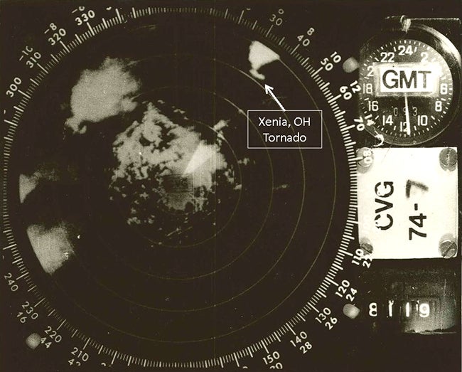 WSR-57 radar image of the Xenia, Ohio, tornadic supercell (upper right) on April 3, 1974.
By now, you most certainly have heard of Doppler radar. Not only is there a network of National Weather Service Doppler radars, but many local television stations also have their own.
In 1974, Doppler radar was merely in development in the research community. Radar available to operational meteorology was crude, by modern standards.
"The radar was very manually intensive, and took a lot of experience for correct storm interpretation," said Allan Fisher, at the time, a meteorological intern at the National Weather Service in Chicago.
Lacking Doppler radar's capability to measure the motion of rain, hail and snow relative to the radar site, meteorologists couldn't diagnose developing rotation in thunderstorms, occasionally a precursor for tornadogenesis. The 1974 Super Outbreak gave a boost in urgency for Doppler radar research and development.
(MORE: Different Types of Tornadoes)
While it took another two decades, the national network of Doppler radars gradually replaced the aging WSR-74 (for 1974) and WSR-57 (for 1957) radars in the 1990s.
Today, these Doppler radars have been upgraded with dual-polarization capability. Dual-pol radar can now detect tornado-lofted debris, giving radar confirmation of a tornado in progress.
2. We Needed More Warning Lead Time
 Radar reflectivity and tornado warning (purple polygon) near Rockville, Maryland, on June 13, 2013.
(Image: Gibson Ridge)
Today, while only a small fraction of rotating thunderstorms actually produce tornadoes, the average lead time for tornado warnings is about 15 minutes. In some cases where a long-track supercell repeatedly spawns tornadoes, the lead time can sometimes be up to 30 minutes.
For example, a tornado warning was issued 39 minutes ahead of an EF5 tornado wiping out Greensburg, Kan. on May 4, 2007.
(MORE: The Future of Tornado Warnings)
3. We Needed to Receive Warnings Instantly
 Teletype machines lined up in the Fort Wayne, Indiana, NWS office in June 1967.
In 1974, tornado warnings were disseminated using a teletype system in which warnings had to be punched into a paper tape, then manually fed through a reader.
With up to 15 tornadoes in progress at one time on April 3, 1974, there was a warning bottleneck. Some warnings weren't transmitted until an hour after the original issuance time.
(MORE: April's Dangerous, Tornadic Reputation)
A faster weather wire was implemented soon after the 1974 Super Outbreak, and warnings were properly prioritized over other NWS products.
Today, we can receive warnings via television, social media, text message or smartphone the instant they are issued.
4. NOAA's Weather Radio Network Had to Expand
 Portable and desktop weather radios. (Photo: Mrschimpf/Wikimedia)
What resulted was an expansion of the NOAA Weather Radio network from only 50-60 stations mostly in large cities near the coasts to include another 330 stations.
For the first time, anyone with a weather radio could be alerted immediately when their local National Weather Service office issues a warning for their area. Later on, an alert tone feature was added to wake someone at night.
(MORE: Find your local NOAA Weather Radio station)
That network would grow to cover 95 percent of the nation's population after the Palm Sunday 1994 tornado outbreak.
Today, there are 1,000 transmitters covering all 50 states, coastal waters, Puerto Rico, the U.S. Virgin Islands and Pacific territories.
5. We Needed Improved School Safety Awareness and Outdoor Sirens
 School
buses rest April 5, 1974, on the remains of the high school where they
were tossed in Xenia, Ohio, by a tornado that went through the town.
School
buses rest April 5, 1974, on the remains of the high school where they
were tossed in Xenia, Ohio, by a tornado that went through the town.(AP Photo)
The town of Monticello, Indiana, lost three schools to one tornado. Twenty-four schools were damaged in the state of Indiana, according to former NWS Central Region Director Richard Augulis. Seven of Xenia, Ohio's 12 schools were hit on April 3, 1974.
"Evidence from the damaged buildings supported the claim that inside hallways provide the safest place and that classrooms with outside walls and gymnasiums with wide roof spans are the most dangerous places for students at school during severe weather," said Augulis.
While meant for those outdoors, a large number of communities invested in tornado sirens after the 1974 Super Outbreak.
6. Many Tornado Myths Were Debunked
 The Sayler Park, Ohio, tornado of April 3, 1974.
 (Frank Altenau via NWS-Wilmington, Ohio)
First, based on damage surveys, meteorologists proved that buildings do not explode due to pressure differences as the tornado passes through. Therefore, wasting precious seconds opening windows to equalize pressure won't do any good.
Other debunked myths involved tornadoes overcoming terrain.
The Guin, Alabama tornado on April 3, 1974 climbed, then descended 1,640-foot Monte Sano Mountain, intensifying as it descended. So much for tornadoes unable to climb or descend mountains.
(MORE: Tornadoes Influenced By Mountainous Terrain?)
The belief of rivers somehow mitigating tornadoes was also blown apart by a tornado touching down at Cairo, Ill., marking the confluence of the Mississippi and Ohio Rivers, as well as the infamous Sayler Park, Ohio F5 tornado crossing the Ohio River.
7. A Blueprint Was Cast For More Routine Storm Surveys
 Tornado tracks from Apr. 3-4, 1974 Superoutbreak. (Credit: T. Fujita)
While damage surveys had been conducted before, the 1974 Super Outbreak offered an opportunity to conduct the largest, most comprehensive storm survey ever up to that time.
Starting from initial reports from the National Severe Storms Forecast Center (now called the Storm Prediction Center) and local newspapers, famed tornado researcher Dr. Theodore Fujita and his group from the University of Chicago (including severe weather expert Dr. Greg Forbes of The Weather Channel), investigated each and every tornado track over the span of just over three months.
In April 1974 alone, Fujita logged over 13,000 flight miles in his Cessna conducted aerial surveys, almost halfway around the world, according to Forbes.
The outcome of this survey: 148 tornadoes, including 30 violent tornadoes (those rated F4 or F5 on the Fujita scale) and a total path length over 2,500 miles.
(INTERACTIVE: Experience the Formation of a Tornado)
Today, storm surveys are conducted sometimes mere hours, but otherwise the day after a possible tornado moves through by a team from the local National Weather Service office.
Often photos and reports during the survey itself are sent via each NWS office's social media accounts.
We also now have an Enhanced-Fujita scale with more damage indicators able to give better estimates of tornado wind speeds.
Dr. Fujita's landmark survey of the 1974 Super Outbreak set the standard.
8. Dr. Greg Forbes' Research Interest Was Cemented

You would think all was well being a graduate student under famed tornado researcher Dr. Theodore Fujita.
"Dr. Fujita was running out of research funds to support my studies," Forbes said. "I was literally in an interview to possibly get funding that would have had me studying the formation of tropical storms off the coast of Africa when a hailstorm came over our building."
Just after the 1974 Super Outbreak, Forbes was told by Fujita his funding would be renewed.
"My doctoral studies were primarily supported by the U.S. Nuclear Regulatory Commission, who wanted to know more about tornado intensity and characteristics in order to ensure reactor safety," Forbes said.
One twist of fate 40 years ago kept Dr. Forbes on a path that would eventually lead him to be the severe weather expert at The Weather Channel since 1999.
Jonathan Erdman is a senior meteorologist at weather.com and has been an incurable weather geek since a tornado narrowly missed his childhood home in Wisconsin at age 7. Follow him on Facebook and Twitter.
MORE: Tornadoes in History
The Weather Company’s primary journalistic mission is to report
on breaking weather news, the environment and the importance of science
to our lives. This story does not necessarily represent the position of
our parent company, IBM.
No comments:
Post a Comment